
Kharkov Regional Sports Committee Collection 1986
First Ascent Category
Report
On the ascent of peak Tri Bashni via the NW wall, category 5B difficulty (first ascent) by the team of Kharkov Regional Sports Committee.
Team leader: Tanets A.A., Rybchenko V.D. Team coach: Artemenko G.P.
310003, Kharkov, Dvorets Truda, Kharkov Oblast Council of the "Burevestnik" Sports Society. 310121, Kharkov, ul. Geroyev Truda, 68 A, apt. 34. Tanets A.A. 310023, Kharkov, vyezd Krasnogo Studen-chestva, 8. Artemenko G.P.
Heights were determined using a map and visually.
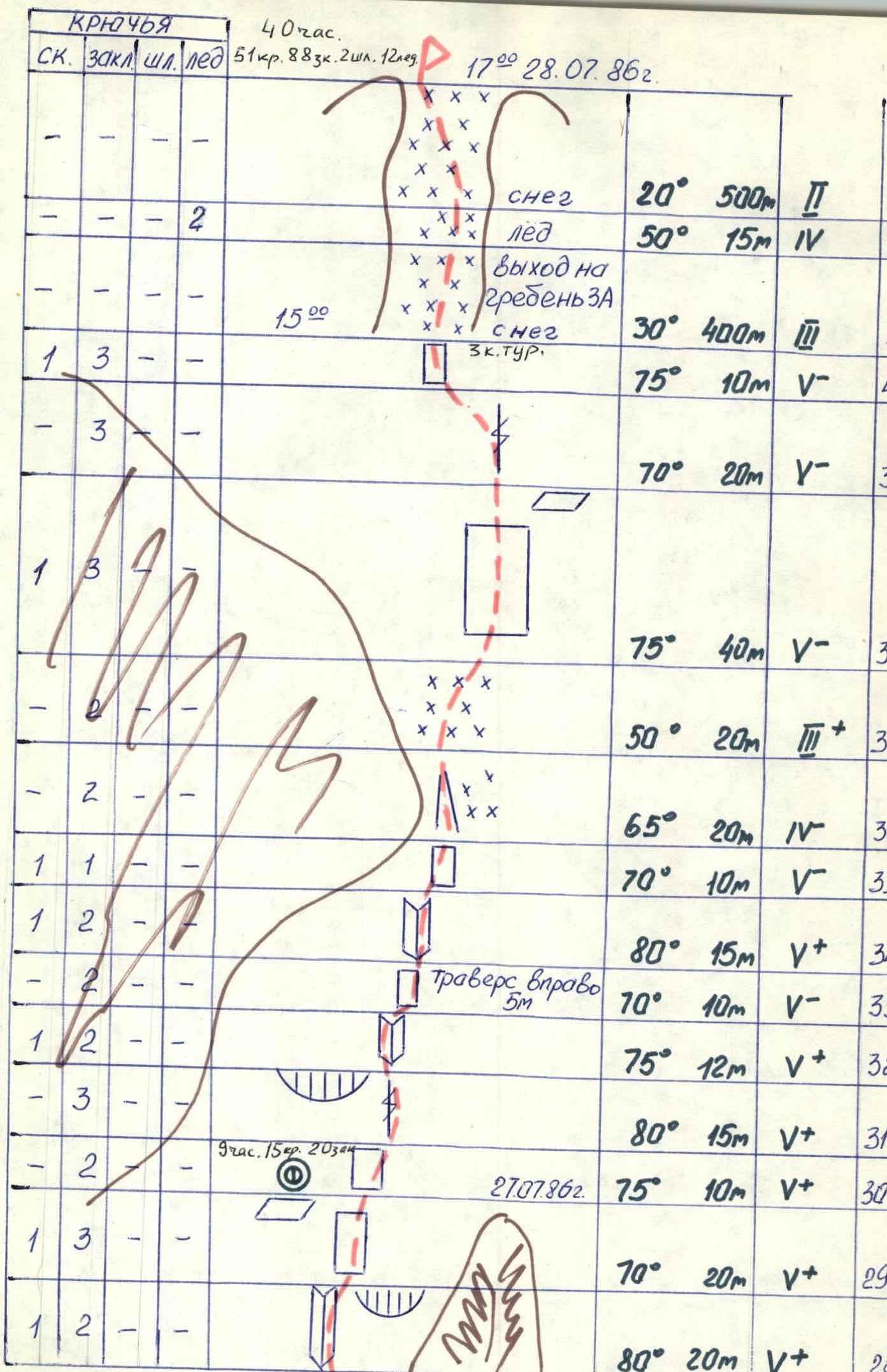
56 rope lengths on the NW wall. 1300, 450, 525, 78°, 51/6 cm, 12/9 ice axe, 88 34, 2 pitons, ug n-g. 40 hours. July 24–28, 1986.
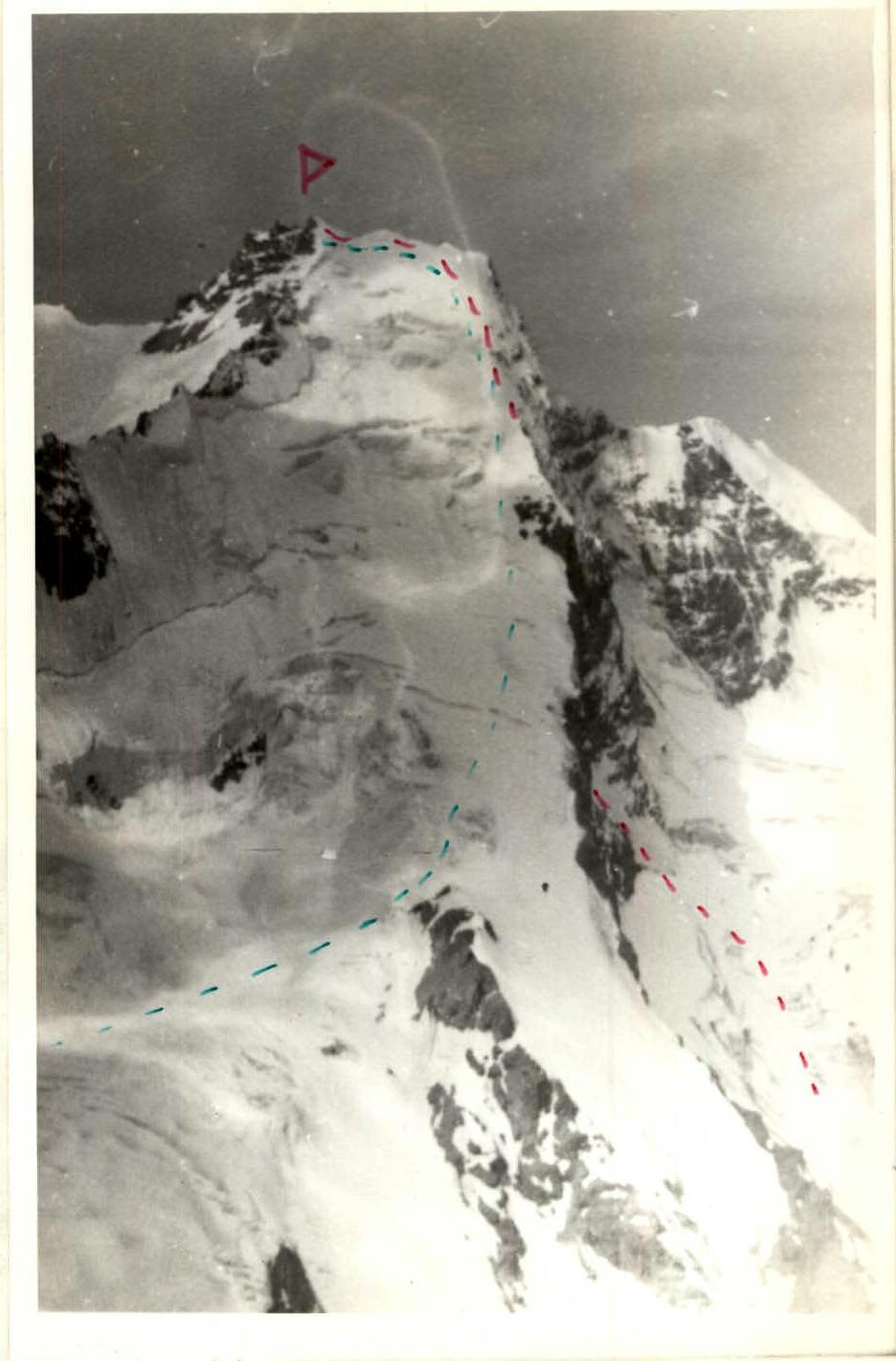
Profile of the wall on the LEFT. Route of ascent — descent route (category 3A). Lens: Jupiter 37, φ135 mm, l = 5000 m, shot point #2.
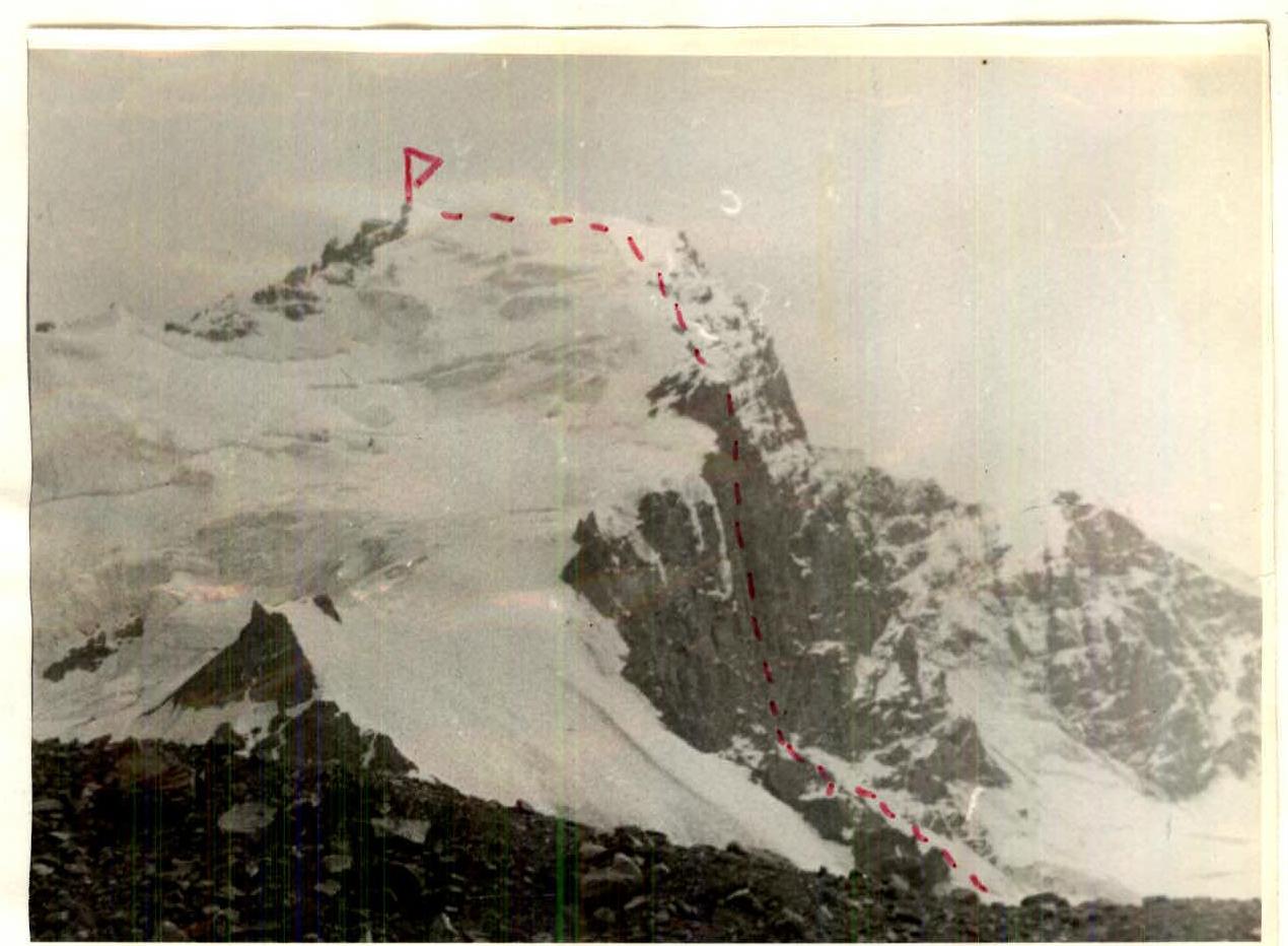
Semi-profile of the wall on the LEFT. Route of ascent. Lens: T20, φ50 mm, l = 3000 m, point #3.
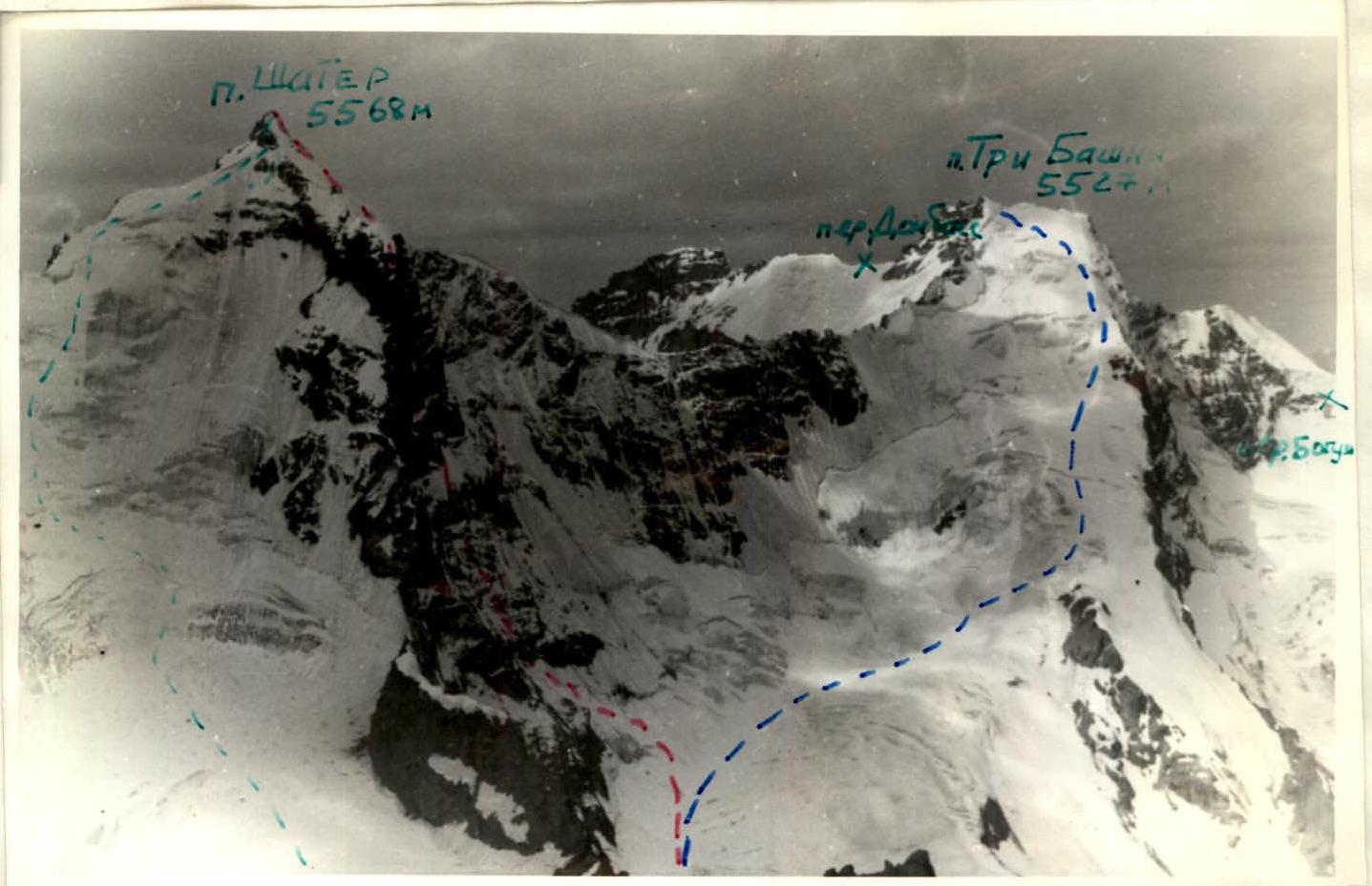
Panoramic Photo of the Area
- Balyberdin's route (category 3) on peak Shater (in category training).
- Category 3A route on the N slope of peak Tri Bashni.
- Category 3A route on the N slope of peak Shater.
- Lens: Jupiter 37, φ135 mm, 5 km, point #2.
Brief overview of the ascent area. Peak Tri Bashni is located in the Shakhdara ridge of the South-West Pamir. It is convenient to travel via the capital of GBAO, Khorog. On the Khorog–Osh highway, 30 km to the village of Anderob, then left 10 km by car to the village of Garm-Chashma. From the village, a trail leads up the Garm-Chashma gorge to the eponymous glacier — about 25 km. The approach from the end of the highway to the base of the wall takes 12–15 hours.
In 1973, an expedition from Kharkov led by Yu. Grigorenko-Prigoda visited the Garm-Chashma gorge. Several first ascents were made, including one on peak Shater. In 1985, Leningraders climbed many new routes and repeated already classified ones.
Until 1986, only one category 3A route had been laid on peak Tri Bashni via the northern ridge, and the interesting NW wall remained untouched.
Tactical actions of the team.
Given the small team size — two people, we decided to minimize our load by reducing bivouac equipment and carefully selecting food. We took on the route:
- a homemade tent (weight 1 kg);
- a "Yuvel" primus stove;
- one pair of crampons;
- one ice axe.
The first climber in the rope worked with a backpack of about 5 kg, and on sections R14–R18 and R24–R27 — without a backpack. The weight of the second climber's backpack was about 12 kg, with a maximum of 17 kg.
Movement was on a double rope:
- one — "Elita" 11 mm;
- the second — domestic production 10 mm.
The first climber worked in galoshes all day. On the next day, the lead climber changed. Thus, Rybchenko V. worked first on sections R2–R4, R12–R19, R30–R38; Tanets A. — on sections R5–R11, R20–R29, R39.
The deviation from the tactical plan (by one day) was caused by:
- bad weather on July 24, 1986, which slowed down the movement and forced us to set up a night camp on section R3 instead of the planned R5;
- the presence on the route of many sections of highly destroyed rocks, which took a lot of time to overcome.
Passing these sections required great nervous tension, which caused rapid fatigue. Much attention was paid to safety when passing rockfall-prone areas. Places for belays were chosen away from the route line and mostly under the shelter of cornices, in niches, etc.
Movement began at 10:00 and ended at 19:00–20:00. Organizing overnight stays took a lot of effort. Meals were organized twice a day — morning and evening, and we also used pocket food during the day. There were no falls or injuries.
Communication with observers was carried out using a "Vitalka" radio station and a flashlight.
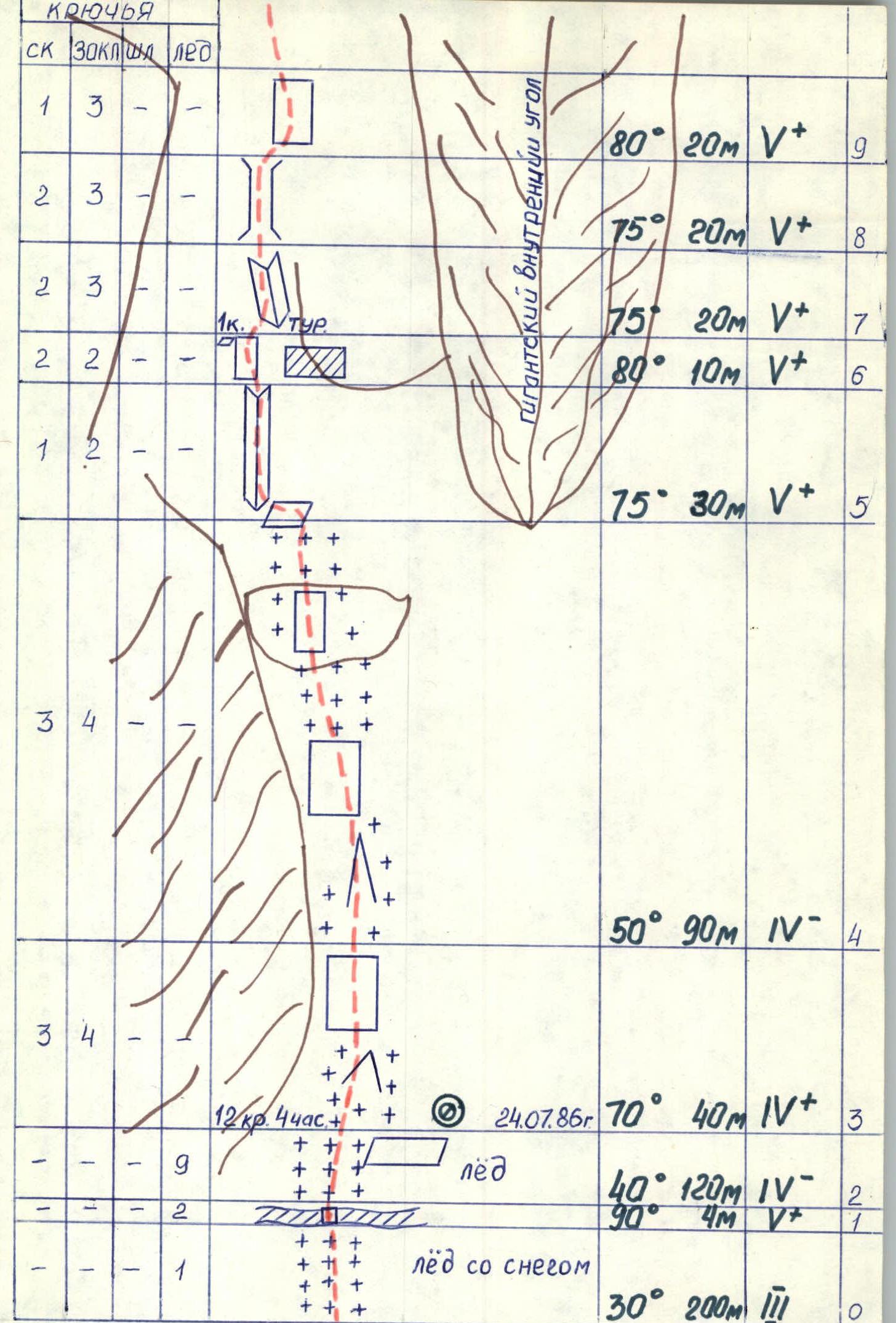
| stop | nuts | pitons | ice screws | Description | Angle | Length | Category | Section |
|---|---|---|---|---|---|---|---|---|
| 1 | 3 | – | – | 80° | 20 m | 5+ | R9 | |
| 2 | 3 | – | – | 75° | 20 m | 5+ | R8 | |
| 2 | 3 | – | 1 | 75° | 20 m | 5+ | R7 | |
| 2 | 2 | – | – | 80° | 10 m | 5+ | R6 | |
| 1 | 2 | – | – | 75° | 30 m | 5+ | R5 | |
| 3 | 4 | – | 50° | 90 m | 4 | R4 | ||
| 3 | 4 | – | 12 kr., 4 hours July 24, 1986 | 70° | 40 m | 4+ | R3 | |
| – | – | 9 | ice | 40° | 120 m | 4– | R2 | |
| – | – | 2 | ice with snow | 90° | 4 m | 5+ | R1 | |
| – | – | 1 | 30° | 200 m | 3 | R0 | ||
| 1 | 2 | – | 80° | 10 m | 5+ | R27 | ||
| 1 | 2 | – | 85° | 15 m | 6 | R26 | ||
| 2 | 1 | 1 | – | 100° | 3 m | 6 | R25 | |
| 2 | 3 | 1 | 90° | 10 m | 6 | R24 | ||
| 1 | – | – | traverse right 8 m | 70° | 10 m | 5– | R23 | |
| 2 | 4 | – | traverse left 5 m | 75° | 15 m | 5+ | R22 | |
| 2 | 1 | – | 85° | 20 m | 5+ | R21 | ||
| 2 | 2 | – | 70° | 20 m | 5– | R20 | ||
| 3 | 2 | – | 10 hours, 10 kr., 16 nuts, 2 pitons. July 26, 1986. 2nd stage. | 80° | 30 m | 5+ | R19 | |
| 2 | 1 | 1 | 85° | 10 m | 5+ | R18 | ||
| 1 | 2 | – | 85° | 10 m | 6 | R17 | ||
| 1 | 1 | 1 | 100° | 3 m | 6 | R16 | ||
| 3 | 2 | 1 | 92° | 5 m | 6 | R15 | ||
| 1 | 1 | – | 85° | 10 m | 5+ | R14 | ||
| – | 4 | – | traverse right 5 m | 75° | 20 m | 5 | R13 | |
| 2 | 2 | – | 75° | 20 m | 5– | R12 | ||
| 5 | 1 | 1 | 10 hours, 21 kr., 27 nuts. July 25, 1986. | 80° | 40 m | 5+ | R11 | |
| 2 | 2 | – | 75° | 15 m | 5– | R10 | ||
| – | – | – | 20° | 500 m | 2 | R43 | ||
| – | – | – | ice | 50° | 15 m | 4 | R42 | |
| 1 | 3 | – | snow 3rd stage. | 30° | 400 m | 3 | R41 | |
| – | 3 | – | 75° | 10 m | 5– | R40 | ||
| 1 | 3 | – | 70° | 20 m | 5– | R39 | ||
| – | – | – | 75° | 40 m | 5– | R38 | ||
| – | 2 | – | 50° | 20 m | 3+ | R37 | ||
| 1 | 1 | – | 65° | 20 m | 4– | R36 | ||
| 1 | 2 | – | 70° | 10 m | 5– | R35 | ||
| 1 | 2 | – | 80° | 15 m | 5+ | R34 | ||
| 1 | 2 | – | traverse right 5 m | 70° | 10 m | 5– | R33 | |
| – | 3 | – | 75° | 12 m | 5+ | R32 | ||
| – | 2 | – | 1 hour, 15 kr., 20 nuts. July 27, 1986. | 80° | 15 m | 5+ | R31 | |
| 1 | 3 | – | 75° | 10 m | 5+ | R30 | ||
| 1 | 2 | – | 70° | 20 m | 5+ | R29 | ||
| – | – | – | 80° | 20 m | 5+ | R28 |
Description of the route by sections. The route can be conditionally divided into three parts — snow-ice approach to the wall, the wall, and the ascent to the summit along the snowy ridge.
The approach to the route is first along the open Garm-Chashma glacier, then a turn to the right towards the glacier at the foot of Tri Bashni. Along the closed glacier to the right-upwards, bypassing to the right the hanging glacier at the base of the left part of the northwest wall. Then — ascent along the snow-ice slope. The steepness gradually increases. The bergschrund is overcome with the help of ice screws. After the bergschrund — an ice slope, overcome in crampons, on the front teeth, belay through ice screws. Movement to the left-upwards. The landmark is the base of the "pillar". 30 m to the left of the giant internal angle — the start of the route. Straight up under a large cornice, which is bypassed on the left. On a convenient shelf (one rope length from the start of the route) — the 1st control point (section R6).
Further:
- two rope lengths along the wet (in the second half of the day) rocks (sections R7–R10) to an inclined shelf (the last one on the wall) under the overhanging rocks (section R11). On the shelf — an overnight stay.
- then to the right, bypassing the overhangs, along difficult rocks 80 m (sections R12–R13) — we approach under a steep internal angle (section R14). The key point of the route. At the end of the internal angle — an overhang and a cornice. Overcome on artificial aids. The rocks are destroyed. Rockfall hazard! Under the cornice (section R15) a piton is hammered.
- after the second cornice — a steep destroyed wall (section R17). After 10 m — a small shelf with a snow overhang. On it — the 2nd control stage. Here you can organize a sitting bivouac.
- further to the left-upwards, first along the wall, then under the overhang to the left (section R20) and along the steep destroyed wall to a small shelf. Climbing is cautious. Check the holds! The main belay points — nuts.
- further to the right-upwards to a sheer internal angle (section R24). The key point of the route. The internal angle and cornice are overcome on artificial aids. After the cornice — a steep destroyed wall (sections R26–R27). Passed by climbing. There are no reliable belay points (section R26). Technically and especially psychologically tense climbing.
- further straight up along steep rocks 40 m to the next overnight stay. The overnight stay is sitting, on a small shelf. We managed to fit both of us, putting our legs into the stirrups.
- the further path goes to the right-upwards, bypassing the overhangs. The landmark is the "breach", in which the exit to the snow is guessed (section R34).
- section R29–R33 is an alternation of monolithic and highly destroyed, delaminating under the hands rocks, folded into walls of various steepness. Climbing is very tense.
- along the snow, along the rocks (pitons belay) under the wall, leading to the top of the "pillar". Climbing is pleasant. On sections R37–R39 — an abundance of holds.
On the top of the "pillar" — the 3rd control stage. Through two rope lengths of rocks — a snow ridge of category 3 difficulty. The further path to the summit is not difficult and is obvious. Takes about two hours.
Section R11. V. Rybchenko. Ascent along the rappel, along the rope fixed in the evening. Lens T20, φ50 mm. July 26, 1986, 11:00.
Section R15. V. Rybchenko. Working on ladders.
Section R32
V. Rybchenko