
Report
On the First Ascent to Peak 5215 m (Soviet Badakhshan Peak) via the West Face in the Southwestern Pamir by the team from the Kharkov Regional Sport Committee:
- BERSHOV S.I. — Master of Sports of the USSR
- BAKHTIGOZIN V.A. — Master of Sports of the USSR
- GRIGORENKO-PRIGODA Yu.I. — Master of Sports of the USSR
- TKACHENKO V.S. — Master of Sports of the USSR
July 28 — August 7, 1975
KHARKOV
– 1975 –
Brief Geographical Description and Sporting Characteristics of the Climbing Object
Peak 5215 (Soviet Badakhshan), West Face.
The Kharkov Regional Sport Committee and the Alpinism Federation organized an alpine expedition to the Southwestern Pamir, Vezdara River valley, in the summer season of 1975, to participate in the USSR Alpinism Championship in the technical category. Teams from the Ukrainian Sport Committee (Severodonetsk) and Donetsk joined our expedition. The combined team worked in the new alpine area of Vezdara.
The Vezdara valley is located in the Southwestern Pamir, 50 km from Khorog city. Khorog is the capital of the Gorno-Badakhshan Autonomous Oblast (GBAO), which celebrated its 50th anniversary in 1975. From Khorog, one can take a regular bus along the Shakhdara River to Roshtkala (43 km), and 7 km further lies the village of Vezdara, at the confluence of the Vezdara River and the Shakhdara River. In Roshtkala, there are:
- shops
- a club
- a hospital
- a school
- a post office
- a village council
- a kolkhoz administration
In Vezdara village, there is a shop and a school. The Vezdara valley stretches for approximately 22 km. At the head of the Vezdara valley, there is the Vez Pass, which leads to the Garm-Chashma valley.
Peaks in this area have elevations of 5000–5200 m, with the highest point being 5243 m — a peak named "Nadezhda" by the Severodonetsk team. Along the Vezdara River, there are sections overgrown with forest. Our base camp was set up in one of these groves. Our base camp was located slightly below the upper summer pasture near a "borjomi" spring (we cleaned it and laid out stone slabs for bathing in the "borjomi").
The area has around 25 peaks that had not been climbed before our expedition. Characteristics of this area include sheer walls with western, northwestern, and northern exposures. Typically, these walls do not have an overhanging roof; instead, they end with a bend and a descent. Many walls have extended sections without snow or water.
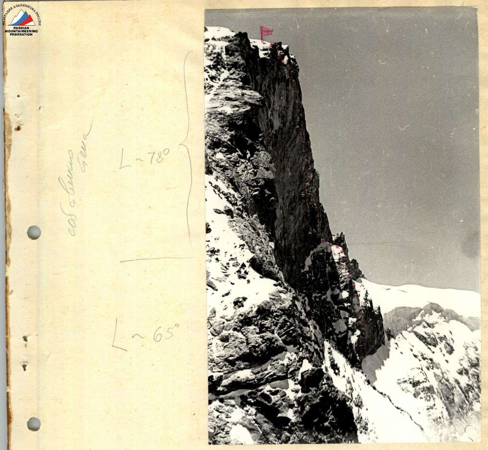
Our climbing object — the West Face of Peak 5215 (which we named Soviet Badakhshan Peak to commemorate the 50th anniversary of GBAO) — has a height difference of 1215 m. The face has a main buttress and a smaller adjacent buttress. The terrain of the face suggested a safe and logical route.
There were no previously climbed routes in the Vezdara area; thus, all the routes we undertook were first ascents.
Experience from expeditions between 1971 and 1975 allows us to state that bad weather in July and August is a rare exception in the Southwestern Pamir.

Map of Vezdara
Southwestern Pamir
Scale: 1 cm — 2 km
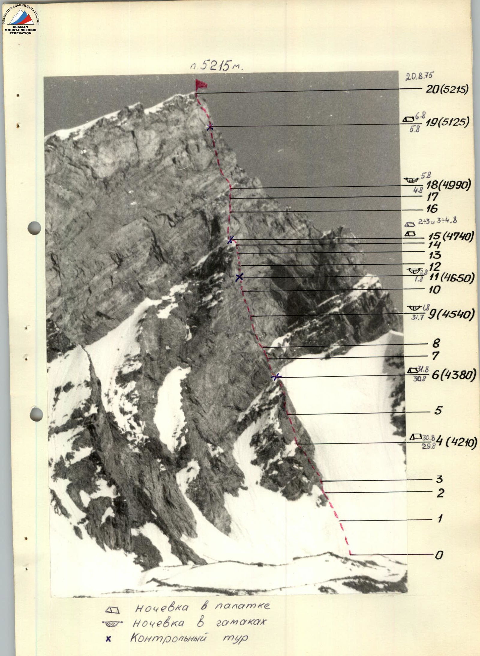
- Overnight in a tent
- Overnight in hammocks X Control cairn
Daily Route Schedule
July 25
Preparation day. We processed a 100 m snow slope and a 100 m ice slope leading to the base of the small buttress. We worked on the rocks at the start of the buttress up to a convenient ledge, where we cached supplies (pitons, carabiners, fuel, some food).
July 28 — Approach from the base camp to the foot of the wall.
July 29 — Start of the route. We traversed the processed section and climbed 100 m of rock on the buttress. Set up a bivouac and processed the small buttress under the main buttress wall (90 m).
July 30: Climbed the processed 90 m section. Set up a bivouac. Processed 80 m of the main buttress wall.
July 31: Climbed the processed 80 m, then another 80 m, set up a bivouac in hammocks, and processed 40 m.
August 1: Climbed the processed 40 m. Climbed 80 m to a balcony. Set up a bivouac — 2 in hammocks and 2 in a tent. Processed 50 m.
August 2: Climbed the processed 50 m. Climbed 70 m to the shoulder of the main buttress. Set up a bivouac on the buttress shoulder. Processed 60 m.
August 3: Processed 60 m, prepared hauling sites, and spent the night on the buttress shoulder.
August 4
Climbed the processed 120 m, then another 80 m, and set up a semi-reclining bivouac on a slanting balcony.
August 5
Climbed 150 m to a slanting ledge.
August 6
- Climbed 100 m and reached the summit.
August 7
- Returned to the base camp.
Description of the Route
Peak 5215 (Soviet Badakhshan Peak) is located in the Vezdara valley of the Southwestern Pamir. From Vezdara village, situated in the Shakhdara River valley, it takes 6–8 hours to reach the foot of Peak 5215. The view of the wall is visible from the last summer pasture. To see the entire route, one needs to reach the glacier and pass by the peak.
On the wall, a buttress with a snowy shoulder stands out clearly. The buttress is located slightly to the right of the geometric center of the wall and rises above the middle of the wall. To the right of the main buttress lies a smaller buttress.
Day 1. Preparation Day. July 25, 1975. We ascended a snow-ice slope to the base of the small buttress (R1 and R2) and reached the rocks at its base (R3). The buttress is primarily composed of slabs smoothed by winter snows. After 40 m of climbing the slabs, there is a convenient ledge with an overhanging wall where one can cache supplies and, if desired, set up a bivouac. The objective of this day was to familiarize ourselves with the route and cache part of the supplies. The slabs slope generally to the right, so dislodged stones fall to the right of those climbing below. To the right of the buttress lies an ice slope that slopes left towards the buttress, and a gully runs along it, through which stones fall. In the morning, stones fall sporadically, but by 12:00, the number of falling stones increases, and the ascent to the buttress rocks is exposed to stonefall. Processing the start of the route to the first convenient ledge, caching supplies there, and descending to the camp under the wall took 4 hours.
Day 2. July 29. Start of the route. We followed the processed section from July 25 and continued up the slabs of the small buttress. The slabs are about 4th category difficulty. The length of the slabs is 250 m. After 100 m, the slabs become steeper and more challenging; here is a suitable spot for a bivouac — a 3 m high walled platform. We set up a bivouac and hung ropes further.
Day 3. July 30. From the platform, we moved up the slabs towards the ridge of the small buttress (R5) — 110 m, 70°, and along the ridge rocks — 100 m, 60°, 4th category difficulty — to the wall of the main buttress. Here, it's convenient to set up a bivouac under a large overhang of the main buttress wall.
Day 4. July 31. The ridge of the small buttress approaches the wall of the main buttress, which starts with a large overhang — 20 m wide. It's better to bypass this overhang to the right (R7) — 50 m, 85°, into a niche under a small overhang. The rocks are steep but quite solid; climbing is very challenging in climbing boots using friction, and handholds are often smoothed. If not climbing in boots, artificial points of support and ladders might be necessary.
From the niche under the next overhang, the path goes left of the niche through the overhang (R8) — 30 m, 95°. Passing the overhang requires the use of ladders. Above the overhang, there's a balcony (compared to the overhang), where one can find some footholds, hammer in pitons, and organize a hauling point for 80 m from the bivouac. Further, the path goes along the wall (R9) — 90 m, 80°. The wall has cracks, though handholds are smoothed. The wall leads to an inner corner where one can hammer in pitons and set up a bivouac in hammocks.
Day 5. August 1. From the bivouac, we climbed the wall to the right and upwards to an inner corner that goes steeply up and abuts against a sheer wall. Along this inner corner, we approached the wall that would lead us to the shoulder of the main buttress (R10 and R11). Under the wall, there's a narrow ledge where a tent cannot be placed, but it can serve as a base for a bivouac, practically a reclining one: two can lie down without a tent, and two can hang hammocks.
Day 6. August 2. From the bivouac, the general direction of movement is left and upwards towards the left end of the buttress shoulder. The wall ends with an overhang, which is bypassed to the right along the edge on slabs (R12) — 30 m, 85°, and then along a steep wall with inner corners and cracks (R13) — 70 m, 95° and (R14) — 20 m, 90° — to the buttress shoulder. The rocks are solid, with some cavelets containing rock crystal. On the buttress shoulder, there's an excellent spot for a reclining bivouac. A control cairn is built on the buttress shoulder from rock crystal.
Day 7. August 3. Day 8. August 4. Along the buttress shoulder on simple rocks (R15) — 30 m, 20° — we approached the wall of the upper buttress. To move along the wall, one needs to go somewhat to the right and then straight up to a balcony located under a ledge. The wall is 250 m long and lacks convenient bivouac spots, so we processed 120 m and returned to spend the night on the buttress shoulder. On August 4, we climbed the processed section and continued to the ledge. On the balcony under the ledge, one can set up a bivouac, practically a reclining one, like before reaching the buttress shoulder. The ledge goes to the right and upwards and gradually disappears.
Day 9. Along the ledge, shifting to the right, we moved along the wall to a slanting ledge that leads to the main ridge. On the ledge, there's a convenient spot for a reclining bivouac. There's little snow, and it may not be present.
Day 10. August 6, 1975. Along the ridge — a wall, and by the nature of the relief — slabs with smoothed handholds — we reached the summit (R20) — 100 m, 80°.
Descent
The easiest descent is to the East. Along the ridge, the descent to the plateau is category 2B–3A difficulty and takes 3 hours. Further down, one descends along scree slopes into the Badom River valley. The journey to the Shakhdara River valley along the trail took 6 hours.
Table of Main Characteristics of the Ascent Route
| Date | Sections Covered | Average Steepness | Length | Route Characteristics and Conditions | Category of Difficulty | Method of Overcoming and Belaying |
|---|---|---|---|---|---|---|
| 1 | 2 | 3 | 4 | 5 | 6 | 7 |
| July 25, 1975 | R1 | < 40° | 100 | Snow slope | 2 | Walking with steps, trench, belaying by climbing, piton belaying |
| R2 | 50° | 100 | Ice slope | 3 | Climbing, piton belaying | |
| R3 | 65° | 40 | Slabs | 4 | Climbing, piton belaying | |
| July 29 | R4 | 65° | 100 | Slabs | 4 | Climbing, piton belaying |
| July 30 | R5 | 70° | 110 | Slabs | 5 | –"– –"– |
| R6 | 60° | 100 | Ridge of the lower buttress | 4 | –"– –"– | |
| July 31 | R7 | 85° | 50 | Wall along the edge of an overhang | 6 | Climbing with ladders, piton belaying |
| R8 | 95° | 30 | Overhang from a niche | 6 | –"– –"– | |
| R9 | 80° | 90 | Wall with cracks | 6 | Climbing, piton belaying | |
| August 1 | R10 | 85° | 80 | Wall with an inner corner | 6 | –"– –"– |
| R11 | 75° | 40 | Inclined wall | 5 | –"– –"– | |
| August 2 | R12 | 85° | 30 | Slabs | 6 | Climbing with ladders, piton belaying |
| R13 | 95° | 70 | Wall, inner corner, wall with cracks | 6 | –"– –"– | |
| R14 | 90° | 20 | Wall with cracks | 6 | –"– –"– | |
| August 3 | R15 | 20° | 30 | Buttress shoulder | 1 | Walking, climbing, belaying |
| R16 | 90° | 120 | Wall, cracks | 6 | Climbing, piton belaying | |
| August 4 | R17 | 95° | 30 | Wall, overhang, wall with inner corner | 6 | Climbing with ladders, piton belaying |
| R18 | 85° | 50 | Wall with inner corner | 6 | –"– –"– | |
| August 5 | R19 | 85° | 150 | Wall with cracks and fissures | 5–6 | Climbing, piton belaying |
| August 6 | R20 | 80° | 100 | Wall, slabs | 5–6 | –"– –"– |
To Peak 5215 (Soviet Badakhshan Peak) via the West Face
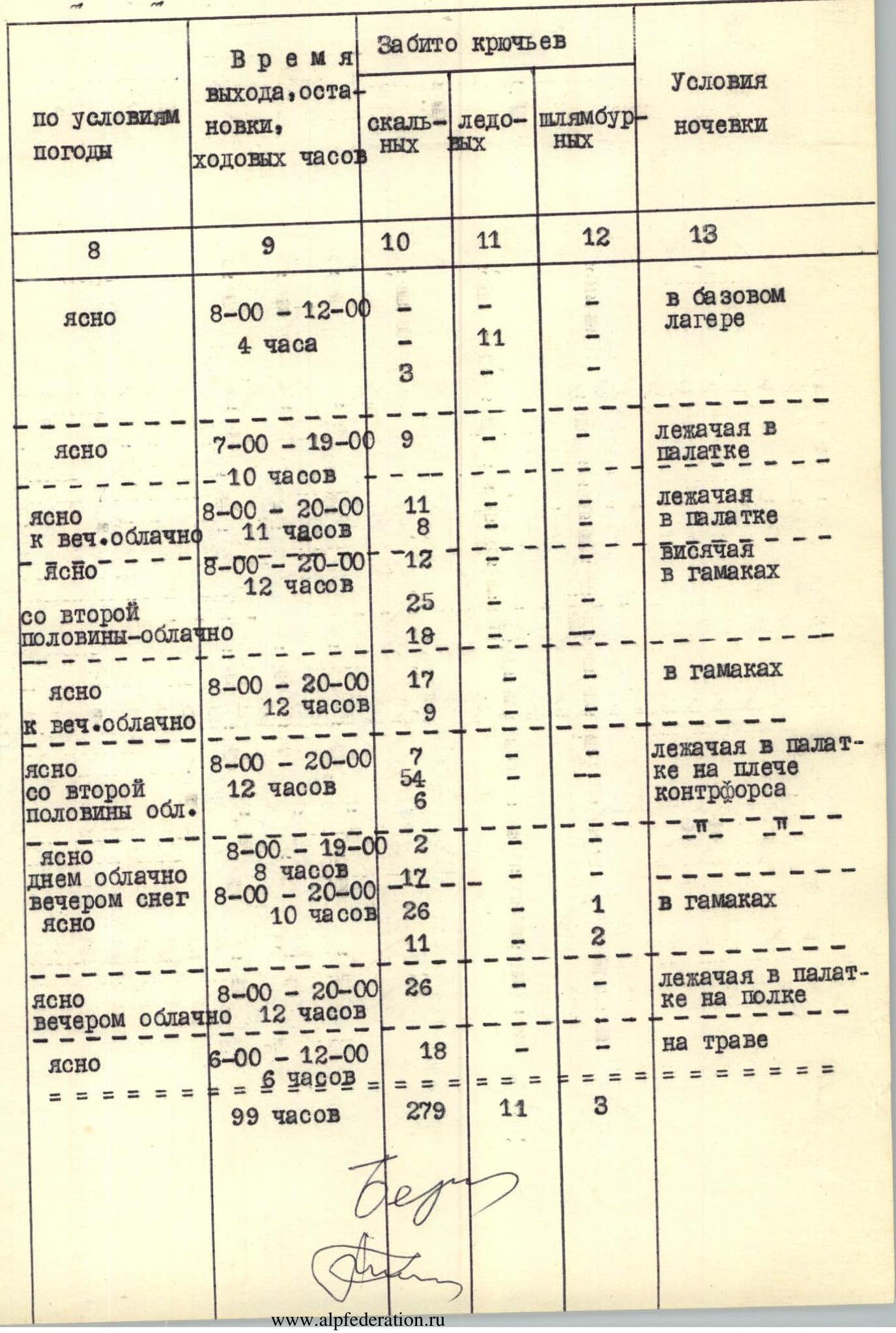
Table of Route Conditions by Day
| Weather Conditions | Time of Departure, Stop, Walking Hours | Pitons Driven | Overnight Conditions |
|---|---|---|---|
| Rock | Ice | ||
| 3 | 4 | ||
| Clear | 8:00–12:00, 4 hr | – | – |
| – | 11 | ||
| 3 | – | ||
| Clear | 7:00–19:00, 10 hr | 9 | – |
| Clear until evening, then cloudy | 8:00–20:00, 11 hr | 11 | – |
| Clear | 8:00–20:00, 12 hr | 8 | – |
| Partly cloudy from mid-day | 12 | – | |
| 25 | – | ||
| 18 | – | ||
| Clear until evening, then cloudy | 8:00–20:00, 12 hr | 17 | – |
| 9 | – | ||
| Clear, partly cloudy in the second half | 8:00–20:00, 12 hr | 7 | – |
| 54 | – | ||
| 6 | – | ||
| Clear during the day, cloudy, snow in the evening | 8:00–19:05, 8 hr | 2 | – |
| Clear | 8:00–20:00, 10 hr | 17 | – |
| 12 | – | ||
| 26 | – | ||
| 11 | – | ||
| Clear, cloudy in the evening | 8:00–20:00, 12 hr | 26 | – |
| Clear | 6:00–12:00, 6 hr | 18 | – |
| ================================ | 99 hours | 279 | 11 |
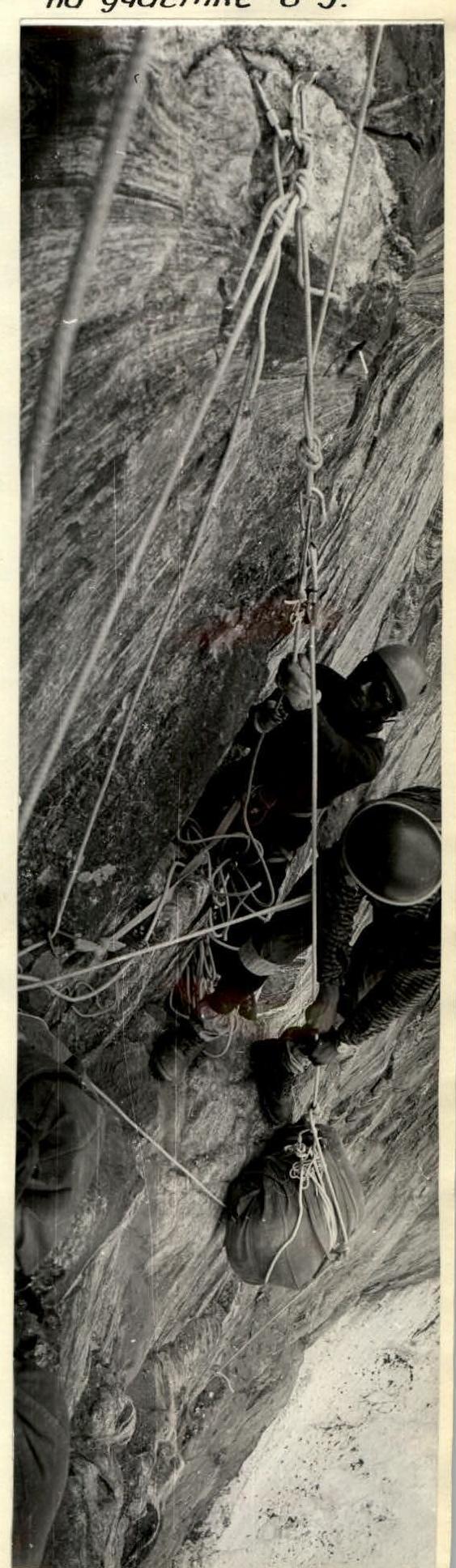
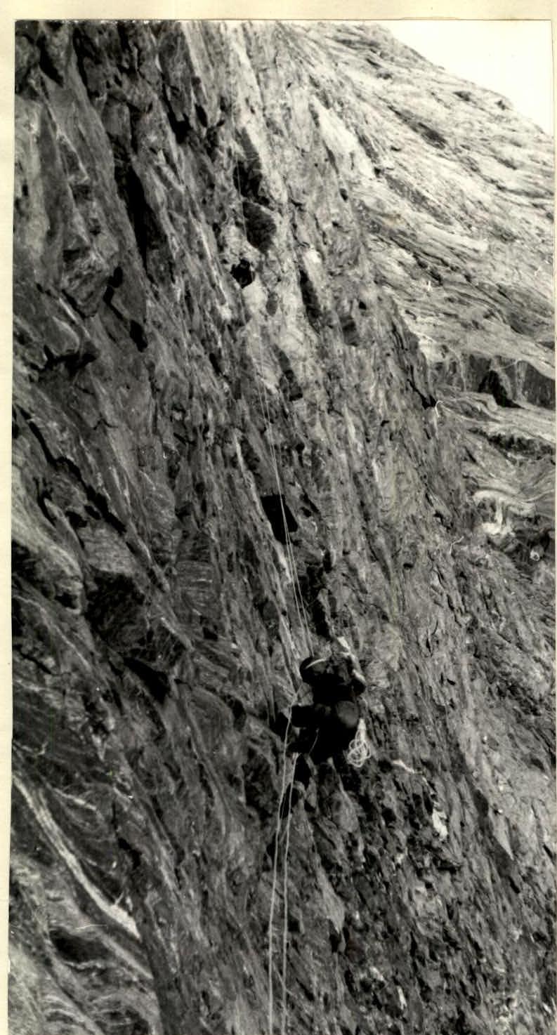 Hauling packs on section R8–R9.
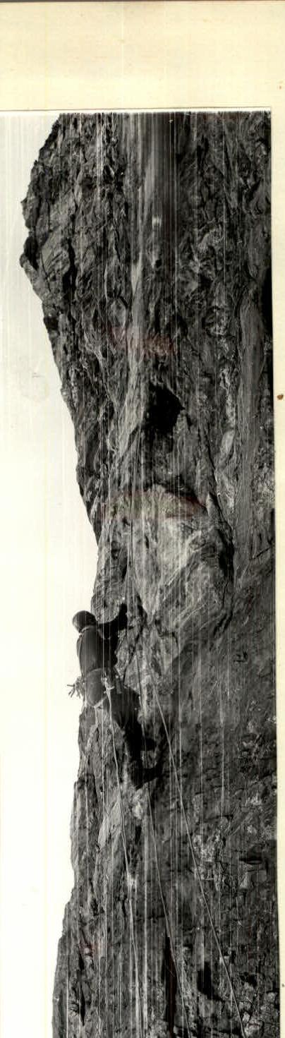
 Passing section R10–R11.
 Hauling packs on section R12–R13.
Passing sections:
- R12–R13
- R13–R14