
4.6.9
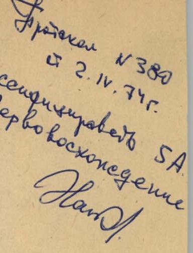
Protocol No.380 dated 2.17.1972. Classified 5A. First ascent. South-West Pamir upper reaches of the Garms-Chashma river, peak 5100 m “Kiik-bal-khana”
Report
- on the first ascent of the South-West wall 5B cat. difficulty by the team of Kharkov regional council of the sports society “Avangard” June 14, 1973
Grushko Yu.I. Candidate Master of Sports Svetlitsky E.D. 1st sports category Chernyshov Yu.K. 1st sports category Poberezovsky V.I. 1st sports category Margulis B.Ya. 1st sports category Kharkov, 1973
Organizational and tactical plan of the ascent
When planning the work of the alpine section of the Kharkov regional council of the sports society “Avangard” for the 1973 season, an expedition was planned to the 0-3 Pamir region, located to the north-west of the Melkovsky peak.
The tasks of the expedition included the development of a new area for alpinism. Including:
- participation of the team led by Grigorenko-Prigoda D.I. in the USSR championship in the class of technically complex ascents;
- participation of the team led by Grushko O.I. in the Ukrainian SSR championship in the class of technically complex ascents;
- improving the sports skills of alpinists-discharge holders, participants of the expedition.
With the help of Aeroflot and the Dushanbe motor transport department, all the expedition participants and cargo arrived through Dushanbe and Khorog in the village of Garms-Chashma on June 5, 1973.
Two base camps were established for the successful operation of the expedition.
- One - in the last grove along the Garms-Chashma gorge at an altitude of about 2500 m above sea level. It was intended for rest after high-altitude exits and ascents. Large tents were set up here, and necessary food and fuel were left. The camp was named “Rayskie kushchi”.
All other expedition cargo was delivered to another base camp (upper), which was organized at the site of the uppermost summer pasture along the Rosto-dara river at an altitude of about 3000 m above sea level.
Carrying cargo by shuttles from the village of Garms-Chashma to “Rayskie kushchi” took two days, and another two days to transport the cargo to the upper base camp.
From the upper camp:
- Acclimatization exits and ascents were carried out;
- Rock and snow training sessions were conducted with the discharge holders;
- During the exits, radio communication was tested, which was carried out using “Vitalka” radios;
- Communication was uninterrupted and stable.
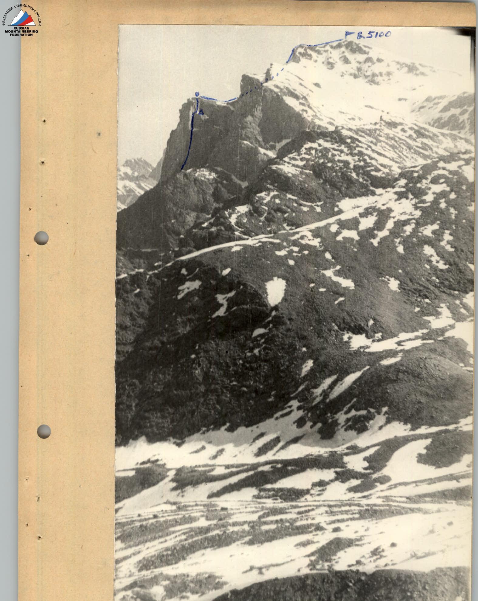 South-West wall of the bastion V. 5100
- Overnight stay from 13 to 14 June.
- Bastion summit and R2.
Route description
The object of the ascent - peak 5100 m “Kiik-bal-khana”, a local, conditional name, is located to the east of the confluence of the Dukil-dara stream into the Rosto-dara river, directly above the upper summer pasture. The western bastion is visible from the upper base camp, located at an altitude of 3000 m above sea level.
The team's route is laid along the south-west wall of the western bastion. The total height gain on the route is 2100 m. 440 m was traversed along the wall with an overall steepness of 80°.
From the base camp “letovok” the path lies along the left ridge. Initially, there is medium scree, then along strongly destroyed rock shelves (section R1). The first large pinnacle on the ridge is overcome on the right side with an exit to the shoulder of the pinnacle. 40 m of medium difficulty climbing along the pinnacle. Hook belay (section R2). The further path goes along the shelves on the right side of the pinnacle with an exit to the ridge (section R3). Before the second pinnacle, traverse the couloir to the right onto the right ridge 60°; 90 m; belay through rock hooks hammered into outcrops (islands) of rocks (section R4). Move further to the right edge of the western bastion along the ridge (slabs, sufficient number of footholds). Climbing along the ridge is of medium difficulty (section R5). On the ridge, 50 m before the wall, a site for one tent was prepared. There is snow nearby. The first control point is on the site. It took 9 hours of work to reach R1 from the upper base camp.
Along a simple rocky ridge 50 m to the “perо” pinnacle (section R6). Bypass the “perо” to the right and down 30 m. Belay through a ledge with a loop (section R7). Ascent 50 m along a narrow, steep, heavily destroyed couloir with an exit to the right and up onto a shelf (section R8). Then traverse with some height gain 95 m. Hook belay. Climbing is of medium difficulty, with 3-5 m difficult sections (section R9). After the traverse, climb up along a vaguely defined internal angle with an overhanging plug at the beginning, 100 m. The rocks are solid, with a steepness of 90°. Ladders were used to pass two cornices. Hook belay (sections R10).
After the internal angle, exit onto ice-covered slabs dusted with snow. 30 m along the slabs (section R11) to an internal angle turning into a chimney under the red rocks. Climbing is difficult, rocks are fragile, and wedges were used for belay. 80 m 90° (section R12) after the chimney, exit to the right onto a snow-covered inclined shelf. On the shelf, using snow, a sitting overnight stay was organized in a suspended tent. It took 16 hours of work from the first control point.
After the overnight stay, climb straight up along very fragile rocks 45 m. Steepness 85-90°, ladders, wedges, rock hooks, and ice hooks into rocks were used. Backpacks were pulled up (section R13).
From here, the ridge begins to the bastion summit. 80 m of rocks with a tile-like structure (section R14). On the bastion summit R2. It took 4 hours and 30 minutes from the overnight stay to R2.
From the bastion to peak 5100 “Kiik-bal-khana” leads a snow col (section R15) and a snow slope with a steepness of 45°. To the summit 240 m (sections R15-R17).
Descent to the north from the col between the bastion and the summit along a steep snow slope, then along rocks into the Dukil-dara gorge. The descent route is approximately 3A category of difficulty. The descent took about 5 hours.
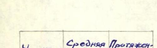
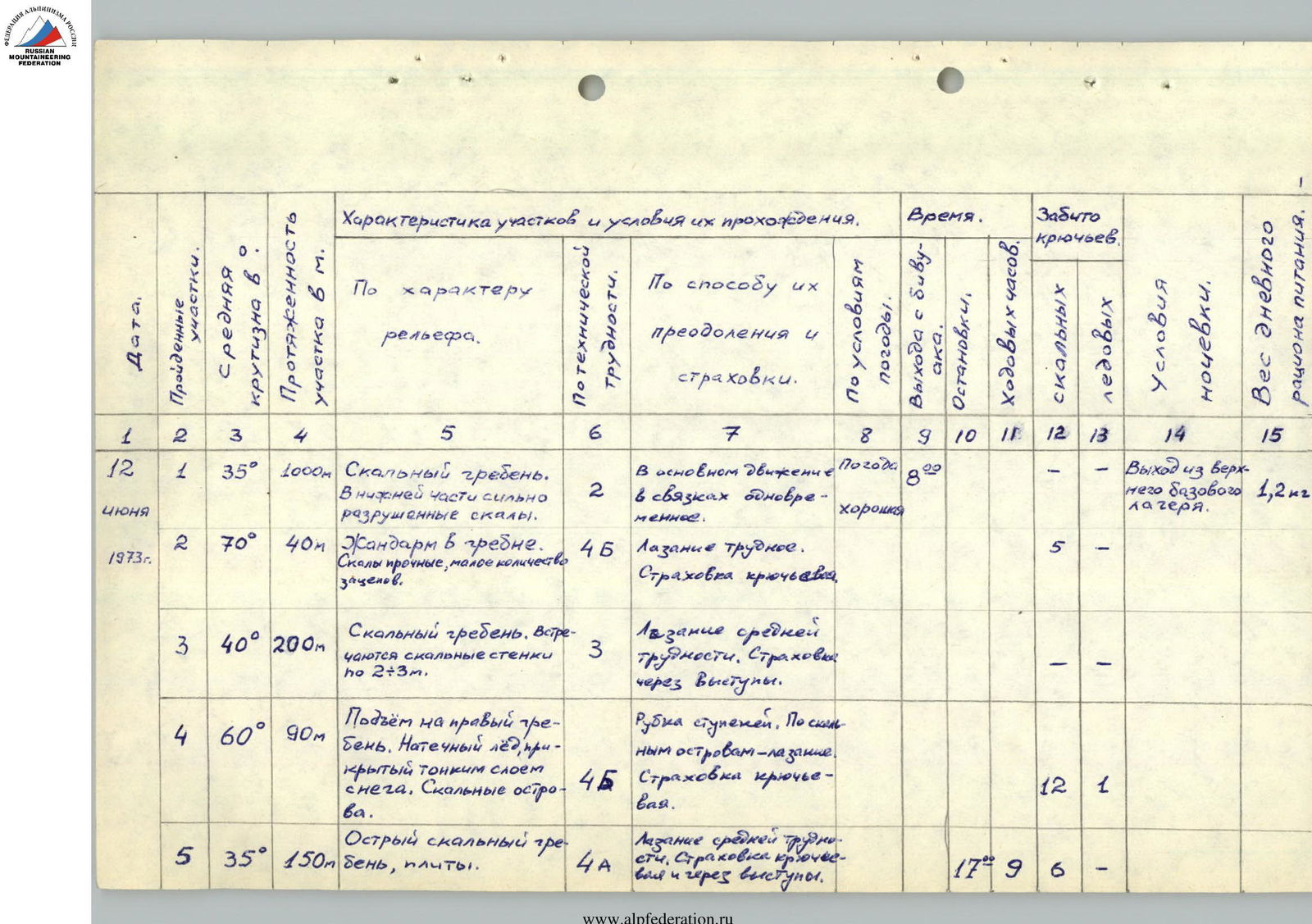
| Section | Average steepness | Length m |
|---|---|---|
| R0–R1 | 35° | 1000 m |
| R1–R2 | 70° | 40 m |
| R2–R3 | 40° | 200 m |
| R3–R4 | 60° | 90 m |
| R4–R5 | 35° | 150 m |
| R5–R6 | 35° | 50 m |
| R6–R7 | 85° | 30 m |
| R7–R8 | 85° | 50 m |
| R8–R9 | 90° | 95 m |
| R9–R10 | 90° | 100 m |
| R10–R11 | 25° | 30 m |
| R11–R12 | 90° | 80 m |
| R12–R12А | 20° | 10 m |
| R12А–R13 | 90° | 45 m |
| R13–R14 | 40° | 80 m |
| R14–R15 | 35° | 80 m |
| R15–R16 | 45° | 120 m |
| R16–R17 | 30° | 40 m |
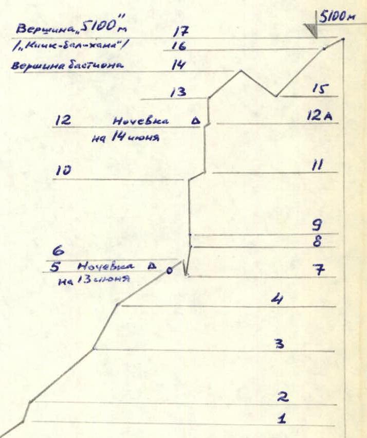
Profile diagram of the route along the south-west wall of the western bastion of peak “5100”.
| Date | Passed sections | Average steepness | Length of section in m | By the nature of the terrain | By technical difficulty | By the method of overcoming and belay | Time | Driven hooks (rock) | Driven hooks (ice) | Overnight stay conditions | Weight of daily food ration |
|---|---|---|---|---|---|---|---|---|---|---|---|
| June 12, 1973 | R1 | 35° | 1000 | Rocky ridge. In the lower part, strongly destroyed rocks. | 2 | Mainly movement in ropes simultaneously. | Good weather | - | - | Exit from the upper base camp | 1.2 kg |
| R2 | 70° | 40 | Pinnacle on the ridge. Rocks are strong, with a small number of footholds. | 4Б | Difficult climbing. Hook belay. | 5 | - | ||||
| R3 | 40° | 200 | Rocky ridge. There are rock walls up to 2-3 m. | 3 | Climbing of medium difficulty. Belay through ledges. | - | - | ||||
| R4 | 60° | 90 | Ascent to the right ridge. Ice accretion covered with a thin layer of snow. | 4Б | Cutting steps. Climbing along rock outcrops. Hook belay. | 12 | 1 | ||||
| R5 | 35° | 150 | Sharp rocky ridge, slabs. | 4А | Climbing of medium difficulty. Hook belay and through ledges. | 5:00 | 17 | 9 | |||
| June 13, 1973 | R6 | 35° | 50 | Rocky ridge, slabs. | 4А | Climbing of medium difficulty. Hook belay. | Good weather | - | 1 | Lying overnight stay in a tent on the ridge | 0.9 kg |
| R7 | 85° (down) | 30 | Descent bypassing the “perо” pinnacle, rocks with a tile-like structure. | 3 | Descent with the help of a loop. Hook belay. | 3 | - | ||||
| R8 | 85° | 50 | Narrow rocky couloir. Rocks are heavily destroyed. | 4Б | Difficult climbing. Hook belay. | 1 | 2 | ||||
| R9 | 90° | 95 | Traverse of the wall with some height gain. Rocks are strong. | 4А | Climbing with 3-5 m very difficult sections. Hook belay. | 10 | - | ||||
| R10 | 90° | 100 | Vaguely defined internal angle (trough) with an overhanging plug at the beginning. | 5Б | Micro-relief is small. Cornices passed on ladders. Hook belay. Backpacks were pulled up. | 23 | 4 | ||||
| R11 | 25° | 30 | Ice accretion on slabs dusted with fresh snow. | 4Б | Ice chopping δ=10 cm. Hook belay. | 1 | - | ||||
| R12 | 90° | 80 | Internal angle. Exit into a chimney. | 5Б | Difficult climbing. Rockfall hazard. Hook belay. | 7 | 1 | ||||
| R12А | 20° | 10 | Inclined shelf with snow. | 3 | Step-kicking. Hook belay. | 21:16 | 6 | 2 | Sitting overnight stay organized in a suspended tent (inclined shelf) | 1.0 kg | |
| June 14, 1973 | R13 | 90° | 45 | Internal angle. Exit to the wall overhang. | 5Б | Difficult climbing. Overhang passed with the help of ladders. Hook belay. | Good. 6:30 | 9 | 2 | ||
| R14 | 40° | 80 | Heavily destroyed rocky ridge to the bastion summit. | 2 | Simultaneous movement of ropes to the bastion summit. | 11:45 | - | - | |||
| R15 | 35° | 80 | Snow ridge - “col”. | 3 | Descent along the ridge with step-kicking. Belay through an ice axe. | - | - | ||||
| R16 | 45° | 120 | Steep snow slope. | 4А | Movement in 3 pitches. Belay through an ice axe. | - | - | ||||
| R17 | 30° | 40 | Snow slope to the summit. On the summit, a rocky outcrop. | 2 | Step-kicking. Belay through an ice axe. | 12 hours 1 minute | - | - |
Descent to the north from the col between the Western bastion and peak 5100 “Kiik-bal-khana” into the Dukil-dara gorge is approximately 3A category of difficulty. The descent took about 5 hours.
- Separately, for pulling up backpacks) 8 rock hooks were driven (3+3+2).
- On section R12А, 6 rock hooks and 2 ice hooks into rocks were driven to organize the overnight stay. In total, 83 rock hooks and 13 ice hooks were driven on the route (excluding blocking).
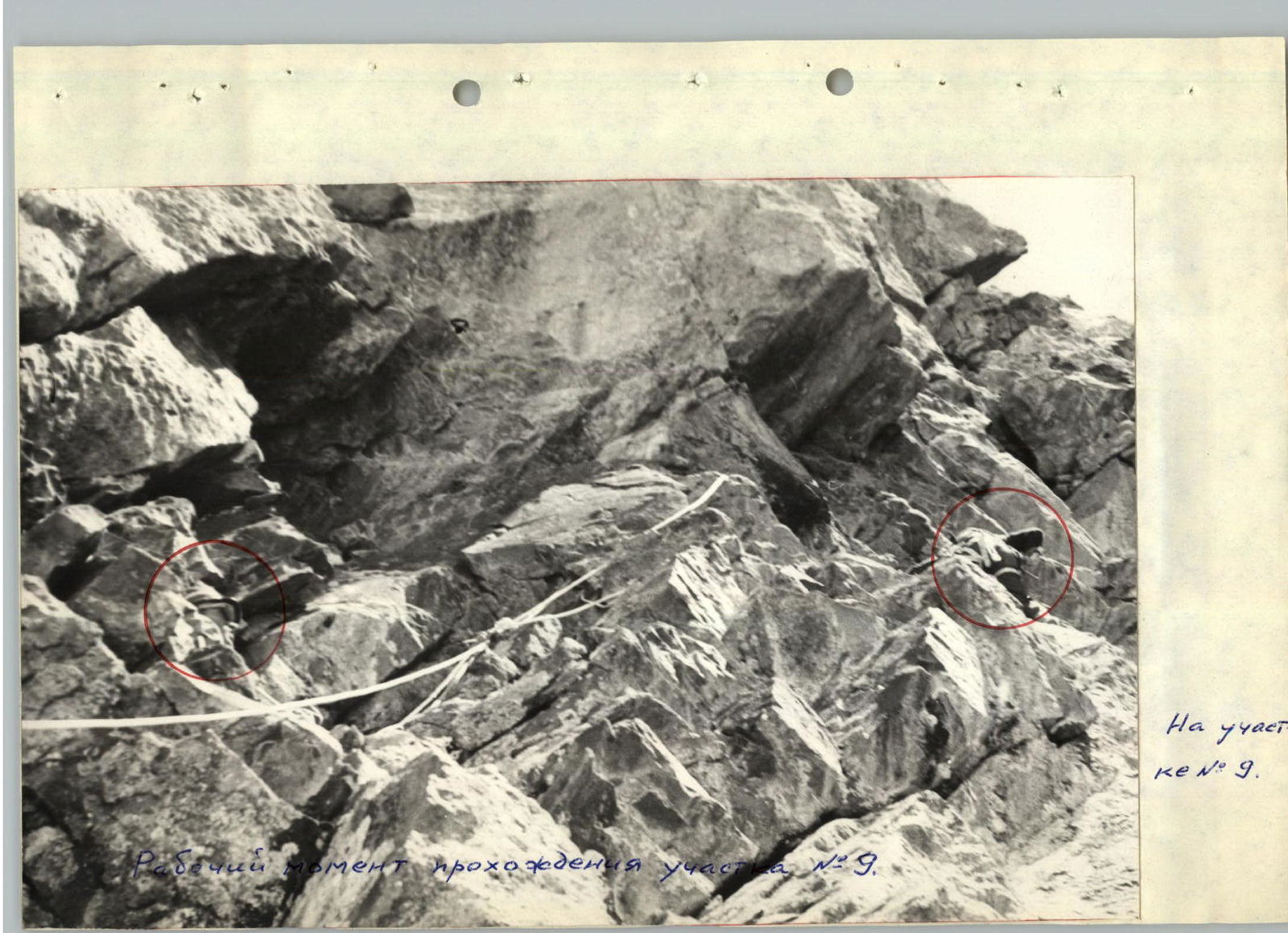
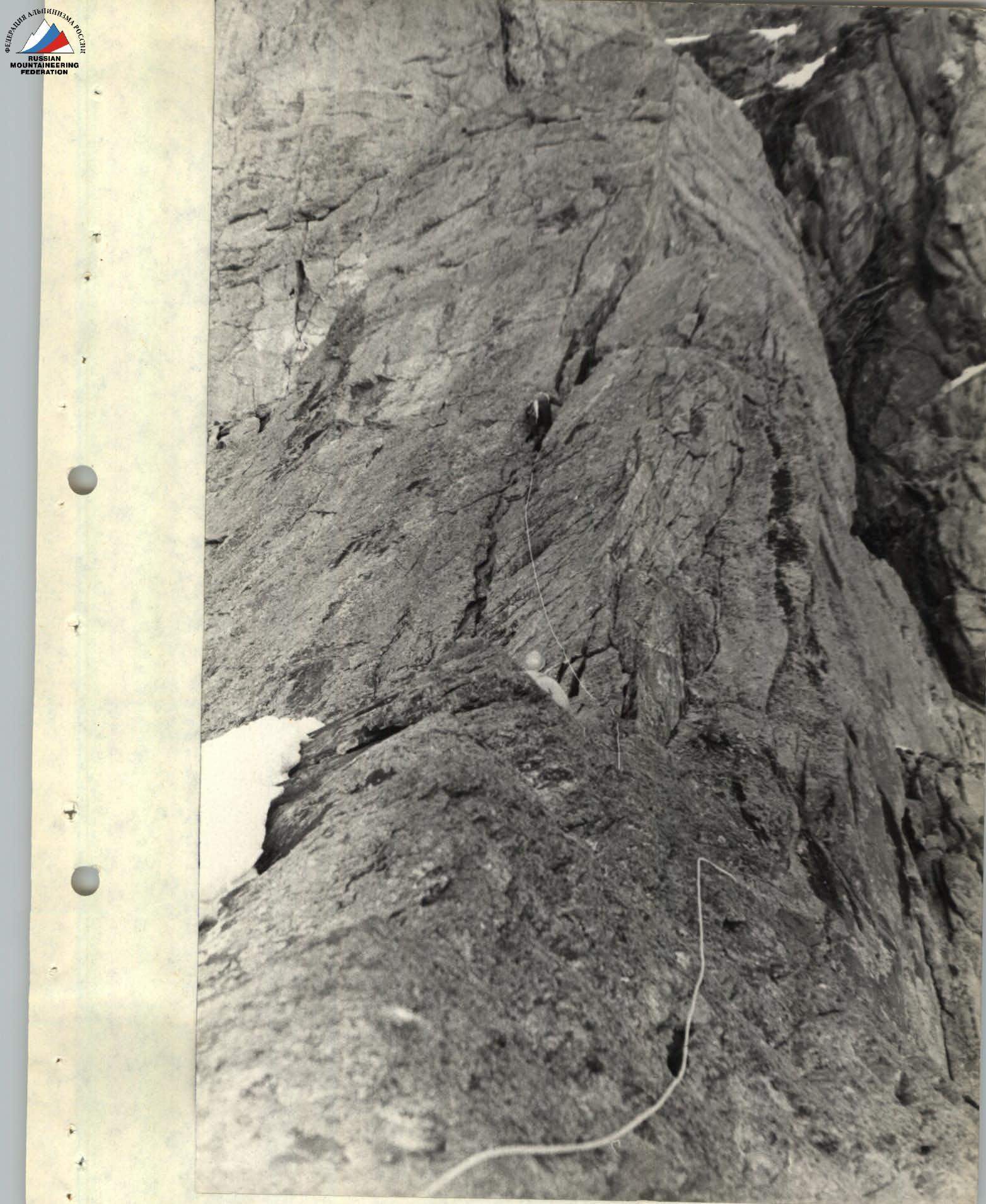 Working moment of passing section R6.
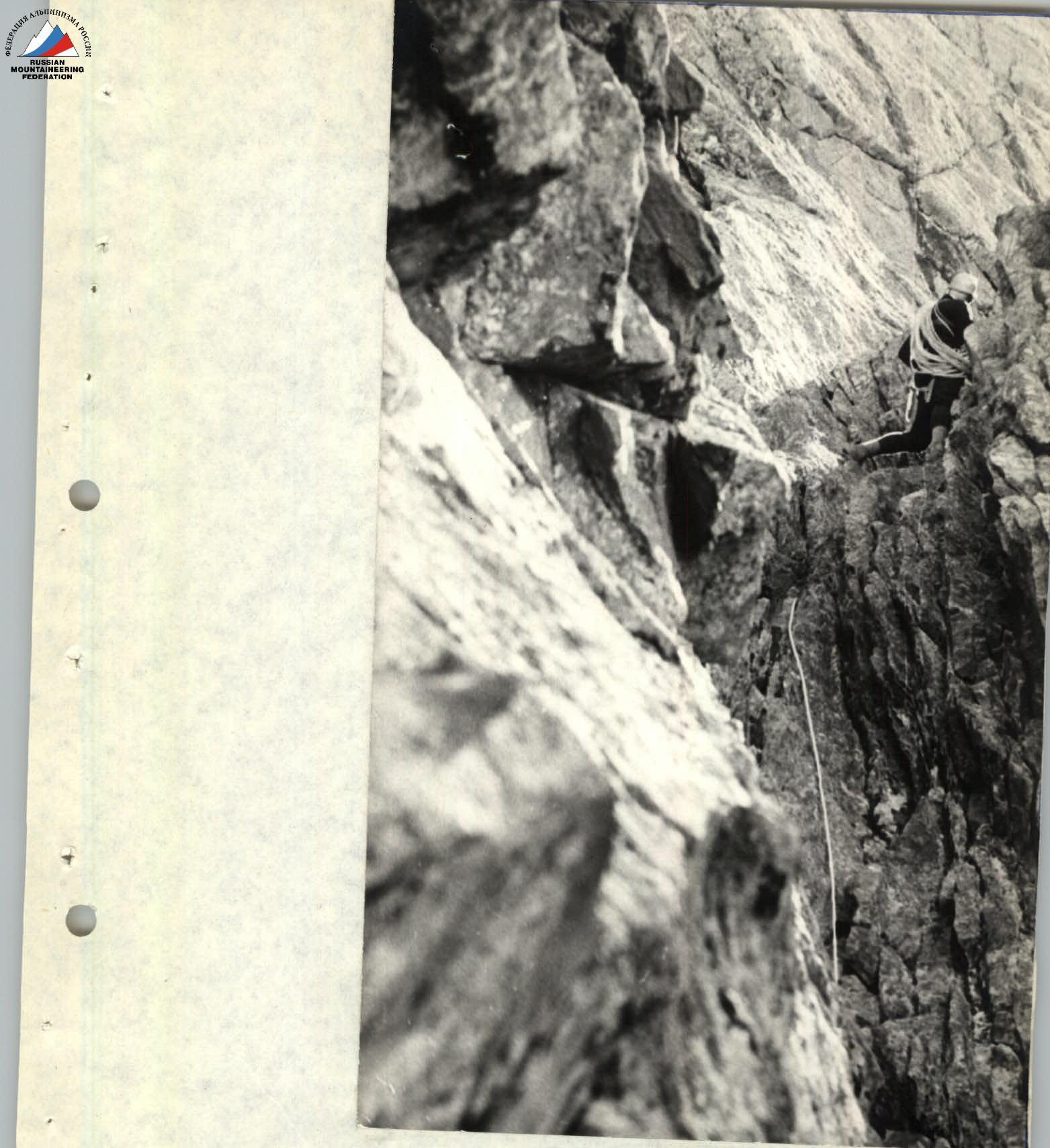 The couloir is passed (section R8).
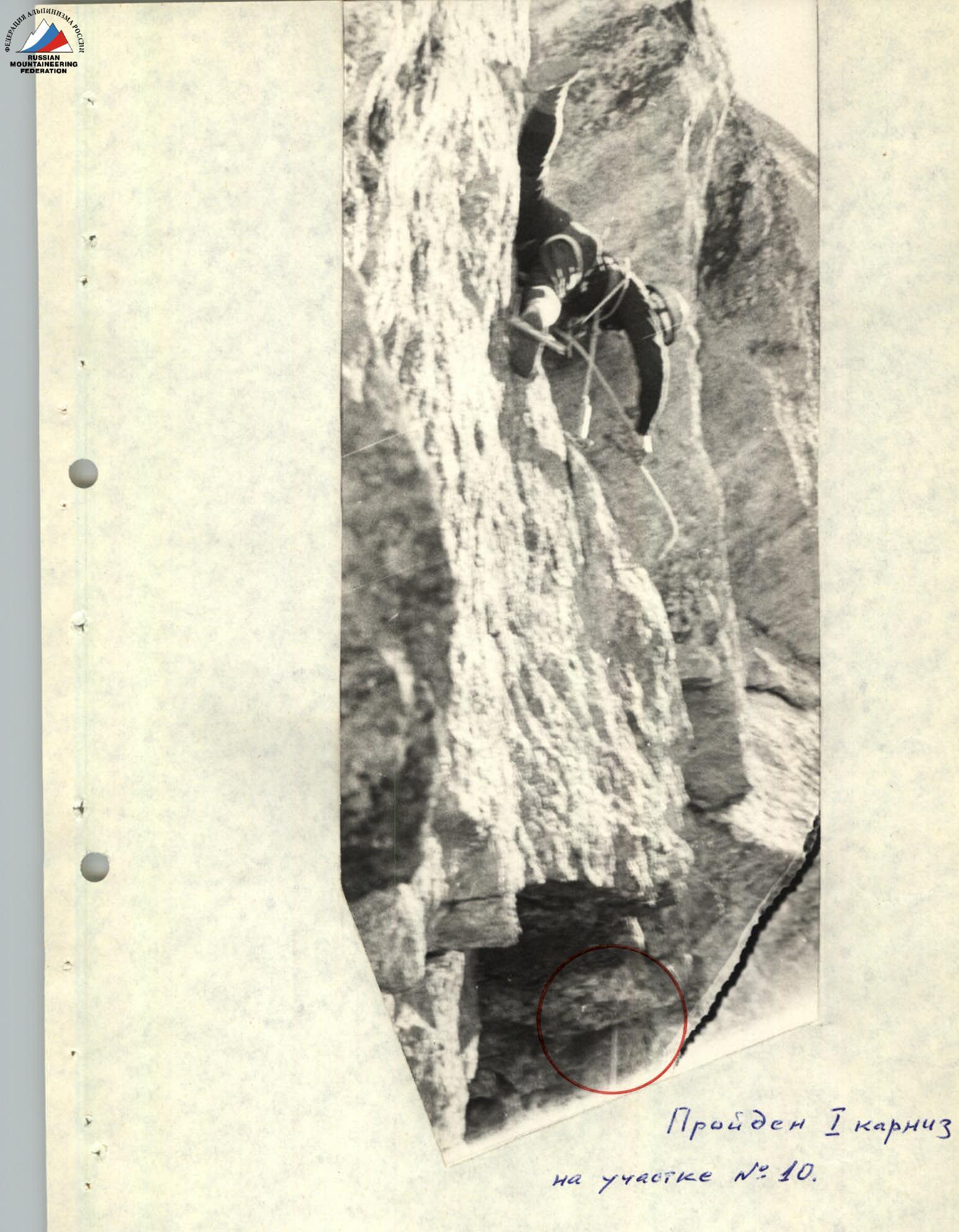 Passed 1 cornice on section R10.