
1. Group Composition
- Yeremenko G. N. — 1st sports category, Kharkov (leader)
- Slobodyanik L. I. — 2nd sports category, Kharkov
- Grigorenko — Prigoda D. I. — Master of Sports, Kharkov
2. Object Characteristics
The Ishpro peak is located in one of the western spurs of the Shakhdarin ridge. The peak and the chosen route are visible when approaching the Andorob village (see Photo 1). It is clearly visible when ascending the slopes above the Garm-Chashma village. The peak is well-known to local residents as its glacial-snow cover supplies the irrigation canal system (aryks) around Garm-Chashma with water. All slopes on the left (orographic) bank of the Garm-Chashma River are crisscrossed by a network of aryks, which are convenient to use as trails when approaching Ishpro peak. Translated, Ishpro means "peak that blocks the wind." We named it "Compass Rose."
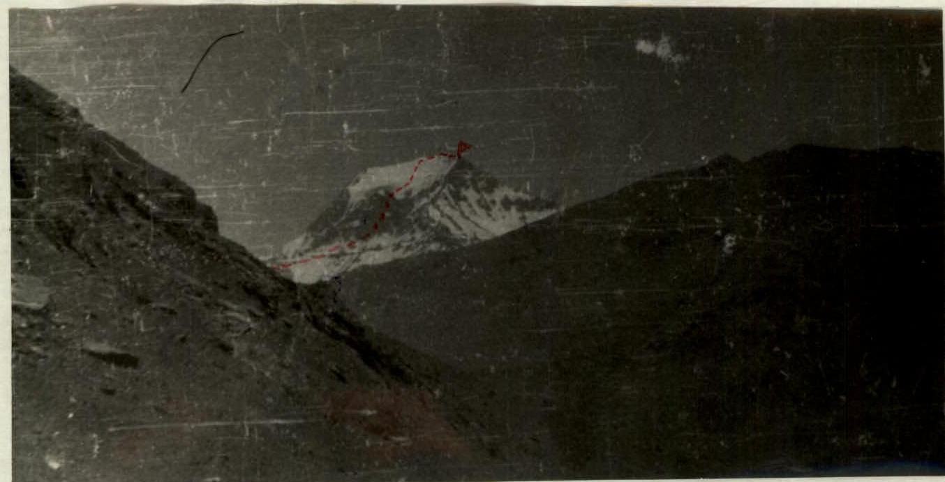 Photo 1. View of Ishpro peak from Andorob village.
Map-Scheme

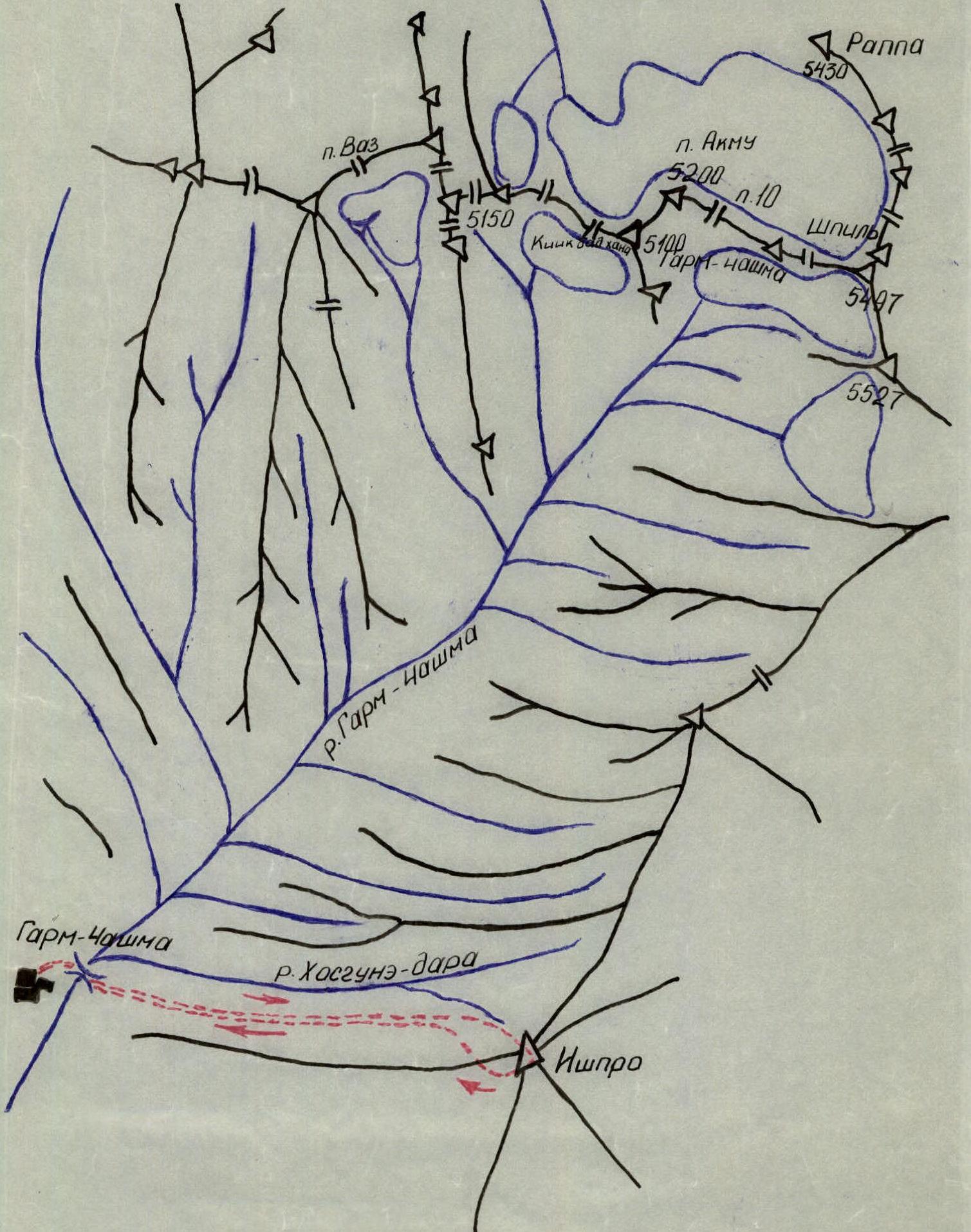
4. Route Description
From Garm-Chashma village, cross the Garm-Chashma River via a bridge to the left bank. Then, ascend the grassy slopes to approach the foot of the northern slopes of Ishpro peak. Initially, it seems logical to follow the trail along the Khosguné River (daara). However, this trail should not be used as it ends abruptly at a steep rocky cliff with very steep grassy slopes.
At the foot of the peak, there is a place for overnight stays and water. The transition takes 6–7 hours from Garm-Chashma village.
Ascend 400 m directly up a rocky counterfort to the right of a snowy couloir (rock with snow) — climbing category 2.
Then, ascend 120 m directly up the rocks — a route of category 3–4 difficulty leads to a wall with a steepness of 75–80° — the key section of the route. Here, the 1st control tour is left. A bit to the right, there is a place for an overnight stay. From the control tour, ascend directly up a vaguely defined internal angle 120 m with complex climbing of category 5. After passing this section, the 2nd control tour is left. There are no platforms for overnight stays or water on the wall.
Then, traverse 60 m to the right (rocks with snow — category 3) — exit onto a snowy-icy slope with a steepness of 45–50°, from which ascend to the pre-summit ridge.
If necessary, overnight stay is possible on the snow. Good platforms for overnight stays are available on the pre-summit ridge, 200 m before the peak. Here, there are large, flat slate slabs where a tent can be set up.
Then, follow the snowy-rocky ridge, which after the overnight stay locations turns into a snowy ridge (very deep snow), category 2 — exit onto the peak.
Descend to the west via a snowy-scree couloir — category 1 — to grassy slopes.
From here, bypassing the peak, descend along the grassy slopes to its northern slopes and down to Garm-Chashma village.
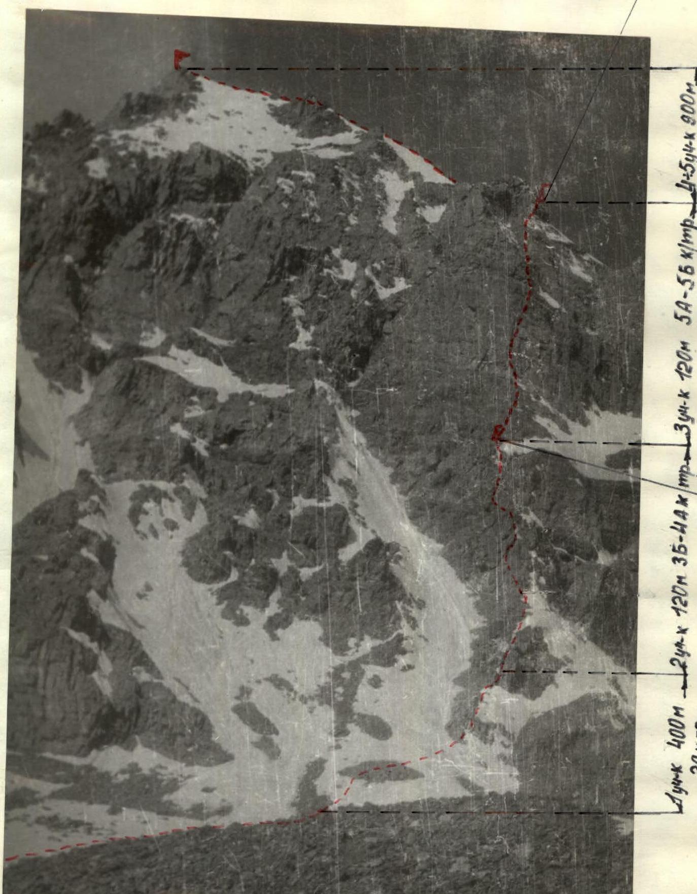 Photo 2. Route breakdown by sections.
 Photo 3. The 120 m wall — the key section of the route.
6. Organizational-Tactical Ascent Plan
To observe the route, the group made a reconnaissance trip to the area. As a result, it was established that the key section of the route is a wall with a height difference of over 100 m, approximately assessed as category 5 difficulty.
It was determined that to overcome this wall, equipment for securing and pulling up backpacks was necessary.
For a group of 3 people, it was planned to take:
- 2 ropes, 40 m each
- 25–30 rock pitons
- 5 ice pitons
- 2–3 ladders
- ascenders for rope climbing.
The route was expected to have 2 or 3 overnight stays (if a simple descent was not found). Since a simple descent was not observed from the reconnaissance, the backup descent plan was to descend via the ascent route to the wall and then to the right of the wall.
7. Route Progression by Day
The group departed from Garm-Chashma village on June 27, 1973, at 11:00. They reached the foot of the peak at 18:00 and set up an overnight stay.
On June 28, at 7:00, the group started on the route, passed R1 and R2, and approached the key section at 12:00. Here, they stopped for an overnight stay and processed the 40 m wall.
On June 29, at 7:00, the group resumed the route. At 16:00, they completed the wall, and at 19:00, they stopped for an overnight stay on the pre-summit ridge.
On June 30, at 9:00, the group reached the peak and began their descent. The descent from the peak to Garm-Chashma village took 6 hours.
8. Route Recommendations
- Group size — no more than 6 people.
- Double rope belay on the wall.
- Have 2–3 ladders.
- Have ascenders for rope climbing.
- Stock up on water for the wall.
- Climb the wall in one day, as there are no overnight stay locations on the wall.
9. Route Assessment
Based on the experience of previous ascents, this route is comparable in difficulty to routes on Dubl-peak (category 5A) and Ualpata (category 5A). Therefore, we assessed this route as category 5A.
Table of Main Route Indicators (see Photos 3, 4)
| Date | Section # | Steepness | Length | Terrain Characteristics | Difficulty Category | Belay Method | Climbing Conditions | Rock Pitons Driven | Ice Pitons Driven | Overnight Stay Conditions |
|---|---|---|---|---|---|---|---|---|---|---|
| June 28 | R1 | 20–30° | 400 m | Rocks with snow | Category 2 | Through ledges | – | – | – | |
| June 28 | R2 | 55–60° | 120 m | Rocks | Category 3–4 | Rock pitons, ledges | 2 | – | – | |
| June 29 | R3 | 75–80° | 120 m | Rocks | Category 5 | Rock pitons | 22 | 2 | – | |
| June 29 | R4 | 45–50° | 400 m | Ice, snow | Category 3 | Ice pitons, ice axe | – | 2 | – | |
| June 29 | R5 | 30–35° | 500 m | Rocks, snow | Category 2 | Ledges, ice axe | – | – | – |