USSR Alpine Union
South-West Pamir
Taversing the peaks:
- peak Akmú (5214 m)
- peak Garm-Chashma (4900 m)
- peak Shpil (5558 m)
- 5350
- (5492 m)
- peak Mayakovsky (6096 m)
Team from Donetsk Regional Sports Committee Captain and coach — Rusanov Viktor Nikolayevich — Master of Sports Deputy captain — Siryachenko Alexander Timofeyevich — Master of Sports Participants
- Zhelobotkin Pyotr Ivanovich — Master of Sports
- Bondarets Stanislav Afanasievich — Candidate for Master of Sports
- Yarovoy Leonid Yakovlevich — Candidate for Master of Sports
Donetsk — 1975
I. Brief Geographical Description of the Climbing Area
The peaks included in the traverse are located in the South-West Pamir, in the north-western end of the Shakhdarin Range. The northern slopes of the range, forming two closed glacial cirques in the traverse area, are the feeding ground for two large glaciers: Bizhuary and Lyadzhuar, with rivers Bizhuary-dara (Gorun-dara) and Lyadzhuar-dara flowing from them, respectively. Both rivers flow into Badom-dara and then into Shakhdara. Additionally, the long north-eastern ridge of Akmú and a spur of the Main Range enclose a relatively small glacier, fed by the north-eastern wall of Akmú.
The feeding ground of the Bizhuary glacier — the eastern slopes of the range section Akmú — peak Garm-Chashma, the northern slopes of peak Shpil, and the western slopes of peaks Bely, Rappa, and Lazur. Lyadzhuar is mainly fed by the snows of the north-eastern walls of peak Mayakovsky and, to a lesser extent, by the eastern slopes of peaks 5350–5492.
The southern side of the range, divided into two parts by a long spur near Shpil, also feeds two large glaciers, which give rise to the rivers Garm-Chashma and Mulvodyzh, flowing into the Pyanj.
The immediate continuation of the range:
- to the west-northwest through Bez to Tusion,
- to the east-southeast to peak Berg, Marx-Engels.
For the first time, a more or less accurate map of the area was compiled by Luknitsky P.N. in the 1930s.
II. Sports Characteristics
The section of the range included in the traverse is not uniform in relief, exposure, and technical difficulty. After the steep and complex north-eastern wall of Akmú, the ridge of the range gently descends to the Desyati pass and is quite complex only in two sections of the rugged, destroyed rocky massif. From the peak Garm-Chashma (4900 m) and almost to the ascent of peak Shpil, the ridge is very rugged, although the amplitude of descents and ascents is small, making it extremely difficult to pass. The rugged, fragile ridge-blade on both sides drops with sheer (to the south) or almost sheer (to the north) walls (slabs).
The ascent from the "notch" in the saw-like ridge to the summit of peak Shpil along the north-western ridge is, in itself, a climb of the highest category of difficulty.
From the summit of Shpil to peaks 5350 and 5492, snow-ice ridges with steep ascents and descents prevail, but they are relatively wide. Only on the descent from peak 5350 — about 200 m of a very complex, destroyed rocky ridge.
A rather complex ascent from the unnamed pass to peak 5492 is due to the presence of long rock "gendarmeres" in the ice ridge, with both gendarmeres and the entire ridge dropping off with a sheer kilometer-long wall on the south-west side. The rubble fields of peak 5492 and a gently sloping rocky ridge turn into a section of a wavy ridge, where:
- the right side (in the direction of travel) is a rocky wall,
- the left side is a steep ice slope.
The ascent of the north-western ridge of peak Mayakovsky consists of three steps of steep, sometimes sheer rocks, alternating with more gentle sections. A characteristic feature is a section of a rubble ridge under the walls of the western tower. The wide rubble ridge, composed of marble-mica debris and relatively gentle, turned out to be so difficult to overcome (very slippery, impossible to find a foothold or belay) that it forced the team to move to the steep ice of the northern part of the wall, as there was a real threat of slipping and falling off the southern steep slopes.
The 600-meter western tower, sheer from the west and almost sheer, but icy from the north, blocks the approach to the summit ridge of the massif, which concludes the traverse. The most challenging section of the summit ridge is the 110-meter wall of the main summit.
The length of the traverse along the ridge from peak Akmú to the eastern summit of peak Mayakovsky in plan is 12 km. The route length is 18 km. The route is characterized by a significant height difference: 4400–5214–4600–4900–4450–5568–4900–5350–4800–5492–5000–6096 m.
Ascents to peaks Akmú via the north-eastern wall, Shpil via the north-western ridge, and peak Mayakovsky via the north-western ridge are each climbs of the highest category of difficulty.
The entire traverse, except for the ascent from pass 10 to Garm-Chashma and a small section of the summit ridge of Shpil, is a first ascent. The traverse is logical and beautiful.
Options:
- less complex — from Shpil to Tri Bashi (Three Towers),
- or from 5350 to peaks Rappa, Lazur.
III. Climbing Conditions in the Area
The area of peaks Shpil, Mayakovsky, like all the mountains of South-West Pamir, is relatively easily accessible. From the highways, both from the north, from Shakhdara, and from the south, from Pyanj, the base camp can be reached in no more than two days by caravan. The need to ensure safety forced the team to make a joint base camp with the expedition of the Kharkov Sports Committee in the Vezdara valley, to the northwest of the area of interest, resulting in approaches during reconnaissance exits taking at least two days from the base camp.
It would be more expedient to make a base camp at the tongue of the Bizhuary glacier (2 days from Shakhdara by caravan or 15 minutes by helicopter) or in the Garm-Chashma cirque (1 day from Pyanj by caravan).
The southern slopes of the ridges are generally sheer and dry, with insignificant glaciation. The northern and western slopes are less steep and more glaciated. The ridge in this area is characterized by a significant height difference: from 4600–4700 m at the passes to 5600–6100 m at the summits.
The prevailing rocks in the massifs are:
- marbles,
- metamorphosed schists,
- complex intrusive rocks, resulting in the ridge crest being either a simple rubble slope or a complex saw-like ridge with gendarmeres of the most bizarre shapes.
The weather in the area is steadily good, although the current year was not characterized by stability. The prevailing winds are from the east and northeast.
IV. Organizational and Tactical Plan of the Traverse
The traverse Akmú — peak Mayakovsky was organized by the Donetsk Regional Sports Committee and the regional alpine club "Donbass".
The calendar plan of the event, contained in the regulations on the alpine gathering, was drawn up approximately but was practically fulfilled within the timeframe with minor adjustments.
The tactical plan of the traverse was compiled after two reconnaissance and training exits, studying both declared routes, observing the most complex or dangerous sections of the route, and included the following:
- The ascent (traverse) to be carried out by a team of five people.
- To carry out the delivery of food and equipment to the "notch" and pass "Burvestnik" for 5 days for 5 people in each delivery.
- The selection of equipment — in accordance with the expected relief, taking into account movement on a double rope.
- Ensuring rescue operations by the rescue team of the Kharkov joint expedition.
- Twice a day (one emergency at 14:00) radio communication with the observation group and daily (in visibility) communication by flares.
This tactical plan was fully implemented. The deliveries made in the right places and in the right quantity fully compensated for the lack of equipment, allowed maintaining a normal diet, and, most importantly, allowed the quantity of food and equipment at any point of the traverse not to exceed a five-day supply, resulting in a small weight of backpacks and, consequently, a high pace of movement. After completion, it turned out that the team, not experiencing any difficulties, practically carried nothing unnecessary.
V. Reconnaissance and Delivery Exits
In accordance with the calendar plan, July 4–7, the first reconnaissance exit was carried out by two groups.
Group I: Zhelobotkin — Bondarets. Objective:
- studying the approaches from the base camp from the Vezdara cirque, assessing the options for the traverse along the visible sections,
- acclimatization,
- deliveries to the Bizhuary-dara cirque.
Group II: Siryachenko — Yarovoy. Objective:
- studying the approaches from Shakhdara through Badom to Bizhuary-dara, exit to Luknitsky pass,
- studying the section of the traverse of the II variant: 3 Bashi (Three Towers)–Shpil,
- acclimatization,
- delivery.
Meeting point of the groups — under the eastern ridge of Akmú on July 6. The second exit was carried out by the entire expedition team from the base camp in the Vezdara valley on July 12–16.
Objective: detailed study of the chosen main variant of the traverse along its entire length, paths for lifting support means, calculation of time, bivouac locations, and a training ascent to a panoramic peak (peak Bely). Deliveries of food to the "notch" and pass "Burvestnik". Testing communication channels.
The training ascent was carried out by: Yarovoy, Bondarets, Zhelobotkin, Rusanov, Siryachenko. Babin, with a severe sore throat, was sent down with Ivanov through Badom.
The first ascent to peak Bely, about 5350 m, from pass Slavutich, the team assessed as category 3 difficulty.
As a result of these two exits, the team had a complete understanding of the length and nature of the route, gained sufficient training and acclimatization, developed a clear tactical plan, made the necessary deliveries, and was fully prepared to complete the declared route.
VI. Composition of the Assault Group
In accordance with the application of the Regional Sports Committee, the team included:
- Rusanov V.N. — Master of Sports of the USSR, "Avangard", Donetsk, captain and coach.
- Siryachenko A.T. — Master of Sports of the USSR, "Burevestnik", Kramatorsk, deputy captain.
- Babin O.F. — Master of Sports of the USSR, "Avangard", Kramatorsk.
- Bondarets S.A. — Candidate for Master of Sports, "Burevestnik", Donetsk.
- Zhelobotkin P.I. — Master of Sports of the USSR, "Avangard", Donetsk.
- Ivanov B.M. — Master of Sports of the USSR, "Avangard", Yenakiyevo.
- Yarovoy L.Ya. — Candidate for Master of Sports, "Avangard", Kramatorsk.
During the preparation for the declared traverse, Babin fell ill and was sent to the base camp accompanied by Ivanov; due to an exacerbation of the illness, they later returned to Donetsk.
The team that started and completed the route consisted of:
- Rusanov V.N. — captain and coach
- Siryachenko A.T. — deputy captain
- Bondarets S.A. — participant
- Zhelobotkin P.I. — participant
- Yarovoy L.Ya. — participant
VII. Route Progression
July 20. At 8:00, we left the base camp for the upper reaches of Vezdara, at 16:00 we ascended to an unnamed pass and, crossing it, descended to the lettovki in the Bizhuary-dara valley by 18:30, where we spent the night above.
July 21. Early rise and exit. At 9:00, we were already under the wall of Akmú. It was planned to approach the route in the second half of the day and start the traverse on the 22nd, but good physical form and acclimatization told otherwise. The weather is excellent. The beginning of the route is not complicated, and after a rest, we decide to start to avoid losing a day.
At 10:30, along a not-steep snowy slope (R1), we reach the beginning of a long rocky rib with small walls of 60° to 90° steepness (R2). With alternating belays, we ascend along the rib, composed of schists, partly mica schists. About 300 m of easy and medium-difficulty climbing, and we approach a steep (45°–50°) snow-ice slope. The snow is typical for the South-West Pamir. The open ice is covered with a stepped snow scale. Two incomplete ropes straight up (R3) to a rocky ledge before the sheer rocky belt. Along two rocky "islands" of black schists with a steepness of 60°, which proved difficult for climbing (R4), and belaying, we reach under the sheer wall of the belt. To the right, in a weakly expressed couloir, the wall is not so steep, but ice periodically falls from there, which we did not observe during reconnaissance. We decide to ascend directly up the non-obvious chimney. It's already 18:00. While the trio chops ice on a narrow ledge, preparing a bivouac site, the duo Rusanov-Zhelobotkin processes the rope on the sheer slope by dusk.
July 22. At 8:00, the duo Zhelobotkin-Rusanov begins further processing of the wall. 40 m along the suspended rope along a sheer chimney-gutter with solid footholds and cracks for pitons. Another 20 meters along the chimney, and it merges with a dome. Climbing is extremely difficult, but it's already warm, the rocks are dry and solid, and the work is highly satisfying. The approaching Siryachenko drives pitons for receiving backpacks and then helps belay Zhelobotkin with a second rope from a ladder. A complex transition under the dome to the right, 2 m, the wall slightly eases, and by the end of the rope, Zhelobotkin reaches a wide crack, obliquely going up to the left. Along the fixed rope, Rusanov ascends, and the trio pulls up the backpacks. Another 20 m along a very difficult crack, similar to the crack of Krestovaya, and we reach a steep snowy ledge (R5). And after another hour or so, by 13:00, the entire team is on the ledge with backpacks. It took about 7 hours to overcome the lower wall belt. Siryachenko and Bondarets ascended the first two ropes on jumars.
At 14:00, dense sleet begins, followed by snow. To the right, up the ledge to a rib, and along it, two ropes of difficult and medium-difficulty climbing straight up (R6) to rocky outcrops on the upper edge of the second rocky belt. Along the ice-snow slope and rocky outcrops to the right, up to a ledge of the second belt, and along it — with medium-difficulty climbing to the walls of the summit tower (R7).
The walls of the summit tower are sheer and monolithic, only on the left are the rocks of blocky structure but heavily snowed and with cornices, and stones constantly fall from there. We are convinced that the path chosen during reconnaissance along the wall of the tower via the internal corner is the safest. It's already 17:00. Again, the trio prepares a bivouac site, and Rusanov-Zhelobotkin process the sheer internal corner. By 19:30, a rope is passed and fixed, pitons are driven under the backpack, and 3 ladders are left.
July 23. The sun illuminates the wall of the tower around 8 o'clock. Immediately, Zhelobotkin-Rusanov-Siryachenko begin the ascent along the suspended rope and gather in the ladders within half an hour. From here, the internal corner continues about 20 m straight up and then bends to the right, turning into a crack filled with ice, leading to a sloping snowy ledge. 80 m of climbing of maximum difficulty and pulling backpacks from the ladders (R8) took more than five hours. Straight up, a wide crack goes, but it's all filled with ice. Along the ledge to the left and up, about 60 m (R9), we search for a path. We don't find anything better than an internal corner with black stains. The corner is not steeper than 70°, but very complex (few footholds, few cracks for pitons) (R10). Fortunately, after 40 m, the rocks ease, about four ropes along rocks of medium steepness and difficulty, and we reach the summit (R11).
After dismantling the control cairn to the ground, we found a can but did not find a note.
From the summit, along a steep chute, 3 sports descents in the direction of the rubble shoulder with a transition to the left side of the chute, then along steep (up to 60°) slabs of the ridge, two rappels to the destroyed slabs, and about 200 m to the rubble shoulder (R1). Overnight stay.
July 24. About 200 m of a destroyed horizontal shoulder lead to a steep drop in the ridge (R2). From the shoulder, along yellow-gray rocks on the right side of the ridge:
- about 180 m of sports descents to rubble ledges;
- 80 m along the ledges to the horizontal part of the ridge (R3).
Along the sharp, fragile rocky ridge, about 300 m of difficult climbing to a deep gap (R4). Two rappels to the right along the way to rocky ledges on the right side of the ridge (R5). Along the ledges, a bypass of the "saw-like" ridge with bizarre "gendarmeres" for about 400 m and further along a simple ridge to pass Desyati (R6).
Along a non-steep, large-rubble ridge with a steep snowy ascent, we reach the summit of Garm-Chashma (R7).
Two rappels to the saddle between the summit and the gendarme "flag" from the summit of Garm-Chashma and to the summit of Shpil, the right side of the ridge is a sheer wall, the left side is steep, sometimes up to 80°, slabs. Descent from the saddle is quite complex along steep slabs on the left side of the ridge and directly along the ridge with sports descents and climbing to the gendarme "zub", which is bypassed along a steep wall on the right (R1). From here, about 500 m of a simple rocky ridge with rubble to pass Luknitsky and along the rocky ridge to pass "lozhny" (false). Throughout the second half of the day, it snows. We set up for the night on the rubble of the false pass already in the dark (R2).
July 25. From the pass, four ropes of the most complex climbing without backpacks along the sharp, jagged ridge and the wall on its right side (R3) to a gently rising 200-meter rocky shoulder with a 40-meter ascent at the end (R4).
400 m of a gentle and wide snowy ridge (R5) lead to an almost sheer gap (R6).
- Two rappels to a light crack.
- Another rope of the most complex descent with climbing to the "notch" (the lowest point before the ascent of the Shpil ridge — height about 4500 m).
And we are at our first delivery, very timely, as food and fuel are running low.
From the crack, four ropes of the sharp, jagged ridge are overcome with the most difficult climbing without backpacks along the sheer walls of the gendarme, first on one side, then on the other (R1), and by 20:00, we gather on a large, light ledge under a нависающей (overhanging) wall. Sitting overnight stay.
July 26. Two ropes to the left and up along loose rocks on a gradually disappearing ledge (R2) — to a steep ice field with outcrops of loose rocks. Two ropes along the ice (R3) — to the base of an internal corner bending to the left with a stream. 60 m up the corner (first without a backpack) (R4). Another two ropes along steep ice (R5) — to a rocky tongue and to the left of it — a difficult exit to the left side of the external corner, along which another rope of difficult climbing leads to a shoulder of the ridge (R6).
Four ropes of a simple ridge (R7) lead to a steep ascent of the ridge with walls about 200 m long, which rests against a нависающей (overhanging) wall of a tower (R8).
On a ledge on the left side of the ridge, we cut out a narrow platform in the ice. Overnight stay is semi-reclining.
July 27. Having convinced ourselves nearby that the exit straight up through the нависающее (overhanging) "belly" of the tower is very complex and will take more than one day, we decide to exit the tower on the left, where it is lower and does not overhang.
Four ropes along the edge of ice and нависающих (overhanging) rocks of the tower onto an ice-snow ridge — behind the corner of the tower and another four ropes of practically horizontal traverse along the edge of ice and rocks to an unobvious corner.
Movement with cutting steps with belay from rocks and ice (R9).
On the right side of the corner, footholds and cracks are visible, as far as can be seen from a rope. We decide to exit here.
From the first meters, the front-runners had to stand in ladders and practically until the end of the 80-meter section of the sheer wall, they did not leave them. For free climbing, the footholds were too rare and small.
Two ropes of the sheer slope with belay on a double rope in ladders were passed in 5 hours (R10).
After spending another hour overcoming a rope of steep, icy slabs (R11) adjacent to the upper part of the wall, we found that the exit to the ridge along a steep ice-snow slope is blocked by huge cornices. There are no platforms for overnight stays anywhere below. We rappel down to under the wall along three fixed ropes and cut out a platform for a good sitting overnight stay.
July 28. The inconvenience of the overnight stay prompted an early rise. The two lower ropes of the sheer slope are overcome on jumars. Pulling backpacks from the ladders through a block-clamp with legs. By 10:00, everyone is at the top.
So, straight up, into the saddle of the ridge, where, as it seemed from below, there is no cornice, there is no exit. We abandon the idea of cutting the cornice. To look out to the right, where the cornice ridge ends, we need to climb about 60 m with step-cutting. We decide to exit on the left, through a black gendarme in the ridge.
Three ropes of climbing of medium difficulty and hard along the upper edge of the wall with occasional step-cutting in the ice, and we move under the gendarme, but the exit to it seems quite complex. It's easier to exit the ridge, continuing movement along the edge of rocks. Another more than four ropes — not steep but partly icy rocks, and we are on the ridge (R12).
About 7 ropes of a sharp snowy ridge, gradually increasing in steepness, a rope of a sharp, gentle rocky ridge, and the sharp summit of Shpil (R13).
From the summit:
- three ropes of descent back along the passed path,
- a rope along gentle rocks towards the south-eastern ridge and along wide snowy fields of the ridge with steep descents to a saddle in the eastern counterfort (R1).
About 700 m of descent to the south along a steep couloir with ice outcrops in the upper part (R2) to a small plateau of the saddle between Shpil and peak 5350.
A gentle ascent to the western ascent of the slope of peak 5350 (R1). About 250 m of an ice-snow slope with rocky outcrops and a flat summit of peak 5350. We are the first on it (R2).
The weather has deteriorated. It's snowing, with strong winds. We quickly build a cairn and write a note.
Four ropes of a sharp, fragile ridge, gently sloping down to the south (R1), although difficult for climbing, are passed fairly quickly with backpacks. From the saddle, where the rocky ridge ends, a gentle snowy ridge stretches. It's already dusk; it's time to set up a bivouac, especially since we've been working for 13 hours. But in case of prolonged bad weather, we decide to reach the delivery. Two non-steep ascents of the ridge, a dome-shaped elevation, and a gentle descent of the ridge to a pass (R2).
Already in the dark, we set up a tent on the exposed rubble of the pass near our delivery.
July 29. The morning is windy and cloudy, but in the gaps between the clouds, the sky is blue. We leave the daily supply of food for the return journey in the delivery.
More than half a kilometer of gentle ascents of a wide snowy ridge (R1) end with a dome-shaped peak, and a sharp, jagged rocky ridge begins.
To the right is a sheer rocky wall. A rope of non-steep rocks to the base of a gendarme (R2), 60 m of bypassing the gendarme on the left along steep ice, and another 60 m along an icy slope of a sharp ridge to the base of the 2nd gendarme (R3).
50 m of the most difficult traverse to the left when bypassing the gendarme (first without a backpack), 50 m of a sharp rocky ridge, a 40-meter rappel into a notch in the ridge, 60 m of ascent along a non-steep, sharp ridge of the 3rd gendarme, and a rope of rappel to a snowy ridge in a gap (R4) took almost four hours.
From the gap, 70 m of an almost sheer ascent were overcome relatively quickly along the wall on the right side with good footholds by free climbing (R5). The first climber went without a backpack.
About 8 ropes of medium-difficulty, partly difficult rocky ridge (R6), 3 ropes of bypassing a gendarme along a rocky-snowy-icy slope (R7), 5 ropes along a snowy slope of the ridge with a mulde (R8), 4 ropes of non-steep rocks of medium difficulty and easy (R9), and a gentle snowy slope of the ridge lead to the rubble summit of peak 5492 m (R10).
Unexpectedly, a cairn with notes is discovered. It was assumed that we would be the first on the summit. A rare snowfall from the morning turns into dense snow after 16:00, coming in gusts.
Descent from the summit along the eastern ridge:
- 200 m of rubble with snow (R1),
- about 600 m of rocky ridge with drops (R2),
- about 800 m of snowy ridge with ascents (R3).
And in the broadening of the ridge on pass Sürpriz 5000 m, a bivouac near a small lake.
July 30. About 10 cm of snow fell overnight, but the morning is calm and sunny. We dry out.
From the pass, 4 ropes along the western ridge of peak Mayakovsky of medium steepness and difficulty to a steep rocky ascent (R1), 100 m of steep and difficult rocks of the ascent (first without a backpack) (R2), and about four ropes of steep and heavy mica rubble, slippery underfoot (R3), lead to a narrow saddle. From the pass itself, to the right, a sheer wall drops off to the south, and to the left, there's a snowy-icy slope. A 400-meter rubble, mica ridge with small but unpleasant walls is overcome with alternating belays, although the overall steepness is not more than 30°. On dense, slippery rubble, it's almost impossible to self-arrest once you start sliding (R4).
The ridge abuts the walls of the western tower of the peak Mayakovsky massif. The northern side of the tower is less steep but icy and with cornices. The right, western wall is almost sheer but dry and seemingly passable by climbing. About 60 m to the right along a rubble ledge to the base of an internal corner.
Three people are busy laying out a platform for a tent, while Rusanov-Yarov begin processing the wall.
A rope of an almost sheer internal corner with solid but large footholds. On the next rope, at the junction of marble rocks with the outcrop of a black body (like tourmaline), the corner turns into a sheer, shallow chimney and ends with a cornice, under which 6 m of difficult traverse on hands to the right onto rounded outcrops of the black body, where the second rope was fixed, pitons were driven for self-belaying and backpacks, and the duo rappelled down to an excellent platform, the construction of which took more than two hours.
July 31. The sun illuminates the wall very late, so we don't wait for it, and although it's quite cold, we begin the ascent along the fixed ropes. Pulling backpacks on the first rope is accompanied by the fall of many stones, but there's a place to hide below.
While the others pull up the backpacks, Rusanov passes a rope to the right and up along smoothed black rocks into a large, inclined corner with an нависающим (overhanging) right side and a cornice at the top, 10 m to the right and up, and, overcoming a half-meter cornice along an internal corner, exits onto a rubble rib, where the rest of the team gathers in another hour.
150 m of an almost sheer wall are passed by free climbing with pulling backpacks in total for 6 hours (R5).
A non-steep, simple rib after 60 m (R6) ends, abutting the same western wall but less steep. Another three ropes of difficult climbing (first without a backpack) along steep, tile-like rocks with cracks (R7), and we exit onto a snow-covered saddle of the summit ridge, 60 m of simple, horizontal ridge (R8), a rope of a steep wall of the ridge along a corner, to the left of an нависающего (overhanging) block (first without a backpack) (R9), and a long, one-and-a-half-kilometer snowy ridge with ascents and low rocky walls begins.
We spent the night on the snowy ridge of the western shoulder.
August 1. Although the morning is sunny and windless, our feet are freezing. The snow is dense, with zastrugs, outcrops of rocky walls are not difficult, and although the altitude is taking its toll, the movement brings great pleasure. At 13:00, we were on the western summit (R10), considering it the central one. We found no signs of human presence on it and built our own cairn. Another half hour to descend to the saddle, bypassing two gendarme on the right (R11), and we faced a steep ascent of the ridge of the central summit.
From under the нависающих (overhanging) rocks of the second gendarme, a rope of icy rocks onto a steep ice ledge and along it to the ridge to the left (first without a backpack). A convenient place for belaying.
Another rope — sheer rocks with gutters and large but fragile footholds, and everything repeats exactly. A steep but wider ice ledge. Five meters to the right of the ridge — a sheer wall of the same structure, at the top of which is the summit control cairn (R12).
The last 70 m, the backpacks were pulled up.
We determined that this is the main summit, wrote a note, and descended along a non-steep and medium-steep slope to the saddle, then ascended along rubble to the eastern summit, did not find a cairn, and since it's already 7 pm, we ran down along a wide snowy slope to the south and further, bypassing the southern walls of peak Mayakovsky and 5492 m, to pass Burvestnik. We spent the night under the pass. The next day, having passed along Lyadzhuar-dara and Badom-dara, we descended to the base camp.
VIII. Assessment of the Route and Participants' Actions
The overall sports characteristics of the traversed route are contained in the corresponding chapters. According to the length, technical complexity, sharp height difference, and its amplitude, the route, in the general opinion of the team, should be classified as the highest category of difficulty.
In addition, the team proposes to classify the ascents to peaks Akmú via the north-eastern wall, Shpil via the northern ridge, and the traverse of peak Mayakovsky from west to east — each as category 5A, considering that there are simple exits to the "notch" of Shpil and pass "Sürpriz".
All participants of the traverse (champions and prize-winners of past championships) proved themselves from the best side. The new team member, L. Yarovoy, organically fit into the team on the first ascent.
All participants of the traverse are proficient in the technique of complex ascents and possess sufficient tactical literacy.
VIEW OF THE RIDGE OF P. MAYAKOVSKY FROM THE WESTERN SUMMIT
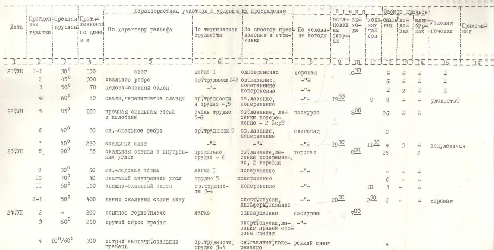
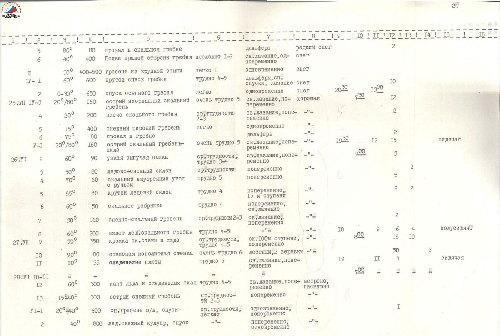
Table of Main Characteristics of the Traverse Route Peaks Akmú — Peak Mayakovsky
Height difference: 4500 m (total) Length: about 18000 m, including the most complex sections — 1460 m
| Date | Sections Passed | Average Steepness | Length, in m | By Relief Character | Characteristics of Sections and Conditions of Passage By Technical Difficulty | By Method of Overcoming and Belaying | By Weather Conditions | Time on Bivouac | Driven Pitons Output | Driven Pitons Rocky | Driven Pitons Shlyambr | Overnight Stay Conditions | Notes |
|---|---|---|---|---|---|---|---|---|---|---|---|---|---|
| July 21 | R1 | 30° | 150 | snow | easy 1 | simultaneously | good | 10:30 | 1 | ||||
| R2 | 45° | 300 | rocky rib | medium difficulty 2–3 | free climbing, alternating | -"- | 6 | ||||||
| R3 | 50° | 70 | ice-snow slope | alternating | -"- | 2 | |||||||
| R4 | 60° | 80 | rocks, schist slabs | medium difficulty and hard 4–5 | free climbing, alternating | 19:30 | 9 | 8 | satisfactory | ||||
| July 22 | R5 | 85° | 100 | solid rocky wall with gutters | very hard 5–6 | free climbing, ladders, alternating — 2 ropes | overcast | 8:00 | 26 | ||||
| R6 | 40° | 80 | snow-rock rib | medium difficulty 3 | free climbing, alternating | snowfall | 2 | ||||||
| R7 | 40° | 220 | rocky edge | medium difficulty | -"- | -"- | 19:30 | 11 | 3 | semi-reclining | |||
| July 23 | R8 | 90° | 85 | rocky wall with internal corner | extremely hard 6 | free climbing, |