
Ascent via the Eastern ridge from the Oktyabrsky glacier. Descent to the Profsoyuzov Pass.
Cat. 4A
Day 1
Departure at 10:00 from the base camp, located at an altitude of 4200 m under the tongue of the Oktyabrsky glacier, on the right (orographic) side of the valley. The path leads along the right side of the Oktyabrsky glacier, first along the lateral moraine, then along the right bank of the Kok-Sai River. Shortly before the glacier, which flows from the Profsoyuzov Pass, one must ascend to the right lateral moraine and reach the glacier along it. The tongue of the glacier, descending from the Profsoyuzov Pass, must be crossed in a rope team with simultaneous belay. The same path is used to cross two more glaciers, which descend from the Zulumart ridge towards the Oktyabrsky glacier. The glaciers are covered with soggy snow and have many hidden crevasses. Under the eastern ridge of peak "6146" on the moraine is a suitable place for a bivouac. The duration of the path from the base camp to the bivouac is 8–9 hours.
Day 2
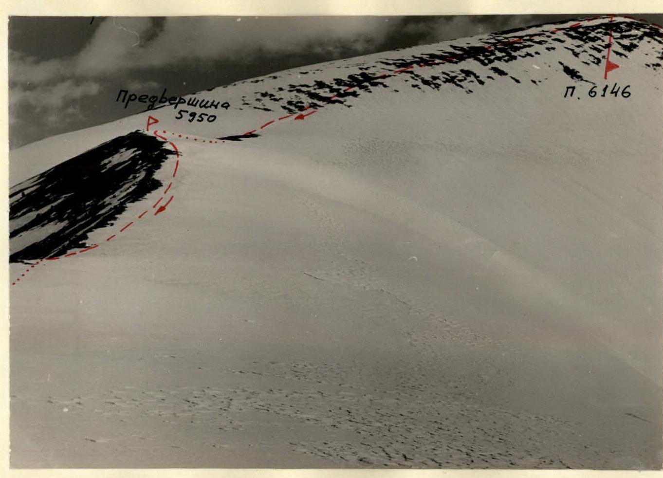
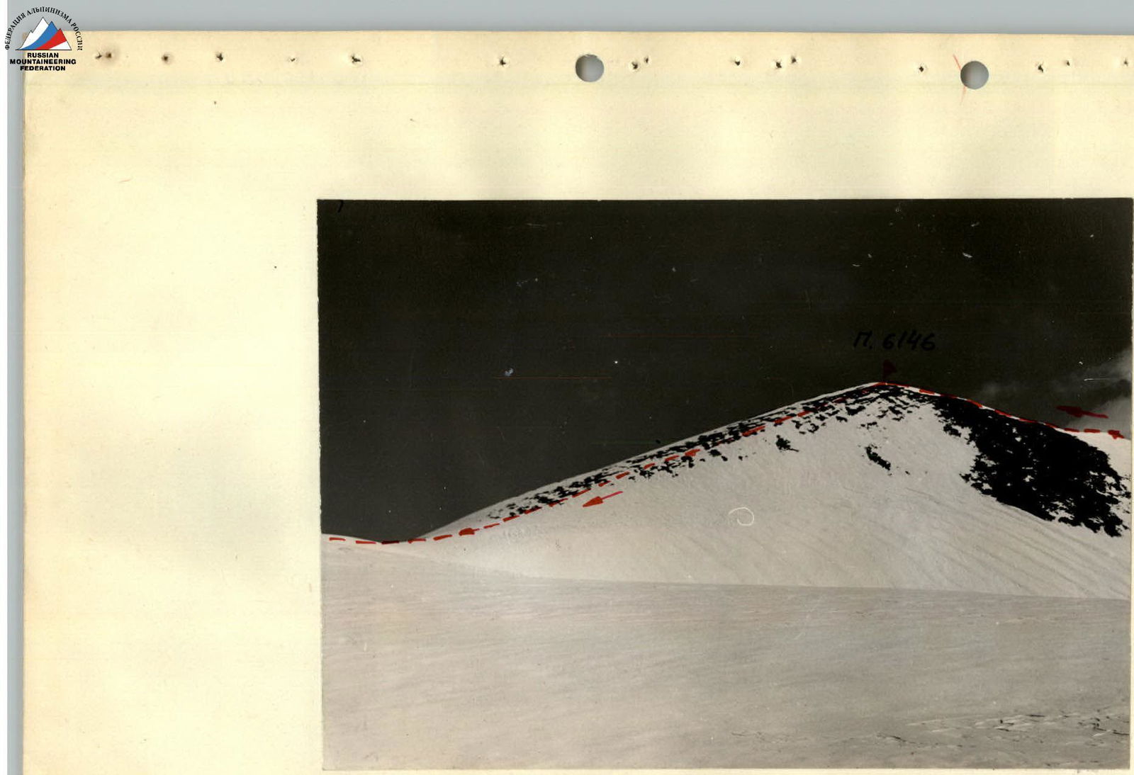
Departure from the overnight stay at 4:30. The bivouac is dismantled. The ascent begins along the slope of the eastern ridge, which is covered with medium scree. Simultaneous belay. The ridge is reached in 30–45 minutes. Further ascent continues along the heavily destroyed rocky eastern ridge of the "6146" summit: The steepness of the ridge is about 35°. There are remains of destroyed gendarmes on the ridge. The ridge narrows higher up. Initially, simultaneous belay in a rope team, and in places where the ridge narrows and when bypassing the remains of gendarmes - alternate belay through rocky outcrops. Requires 3–4 hours. The rocky part ends, and the ridge is further covered with hard snow. The steepness of the snowy section is 40°. The section is overcome in "three steps", in a rope team, with alternate belay through an ice axe. After an hour and a half, a short but sharp rocky ridge with a steepness of about 40° is reached. Belay is alternate, through rocky outcrops. The rocky part ends, and a narrow, long snowy ridge begins with a steepness of 45°, in places up to 50°. On both sides of the snowy ridge are steep ice drops. The snow is hard in places, requiring step cutting; in places it is fluffy, and climbers sink up to their waists. This section is overcome with alternate belay in "three steps". The pre-summit section is a snowy ridge with a steepness of about 15°. The snow is fluffy in places and sinks deeply. The section is overcome in a rope team, with simultaneous belay. The slope of the summit dome is covered with small scree, partially covered with snow. Steepness is about 25–30°. The ascent along the snowy ridge to the summit takes 7–8 hours. Descent through the sub-peak (5950 m) to the Profsoyuzov Pass. During descent:
- The upper part of the summit dome is covered with medium scree.
- Further descent is made along the snowy slope of the sub-peak, which is covered with a crust that cannot support a climber.
- Movement is in a rope team, with simultaneous belay. Descent from the summit to the pass takes 3 hours. A bivouac is set up on the Profsoyuzov Pass.
Day 3
Departure from the overnight stay at 10:00. The descent continues in the direction of the Oktyabrsky glacier along the right (orographic) side of the glacier, descending from the Profsoyuzov Pass. In the middle part of the closed glacier, there are many wide crevasses. Movement along the glacier:
- in a rope team,
- simultaneous belay. Overcoming crevasses - with alternate belay. Further, the path leads along the right lateral moraine of the Oktyabrsky glacier to the base camp. Descent from the Profsoyuzov Pass to the base camp takes 5–6 hours.
Conclusion
The traverse of peak "6146" turned out to be technically average but physically exhausting. The route was snow-rock. The more difficult section was the snowy ridge with a height difference of 700 m due to:
- the steepness of the slope;
- the absolute height;
- the nature of the snow. The snow was hard in places, requiring a lot of effort when cutting steps; in places it was fluffy, where climbers had to make a trench. Passing the route from the bivouac to the Profsoyuzov Pass was possible in one day thanks to the joint efforts of two groups (8 people), which joined forces on the route (at the end of the rocky section). It also played a significant role that all participants in the ascent already had excellent acclimatization and were equal in strength - this allowed everyone to work equally as leaders. With a small group (4 people), traversing in one day, in our opinion, is impossible, and a second overnight stay on the ridge is required at the end of the rocky section. Taking into account all the above factors, we propose to evaluate the traverse of peak "6146" with ascent along the eastern ridge and descent to the Profsoyuzov Pass as Cat. 4A. Composition of one group:
- PARK O.V. (leader),
- PALMISTE K.L.,
- PRIIMETS I.A.,
- AGASILD Z.A. Composition of another group:
- UUSNA A.A. (leader),
- PALO I.O.,
- RETSALU S.A.,
- TOHVER Yu.Yu.
Descent from peak "6146" through sub-peak "5950". Route traverse to peak "6146" along the eastern ridge from the Oktyabrsky glacier. Descent to the Profsoyuzov Pass.


| Date | Section | Steepness of the section | Height difference | Character of the terrain | Technical difficulty | Method of overcoming and belay | Weather conditions | Departure time | Time of stopping at bivouacs | Hiking hours | Rocky | Ice | Pitons | Bivouac conditions | Note |
|---|---|---|---|---|---|---|---|---|---|---|---|---|---|---|---|
| 26.07 | 1 | 30° | 300 m | Lateral moraine and glacier covered with moraine | Simultaneously without a rope team | Sunny, windless | 10:00 | 4 | |||||||
| 26.07 | 2 | 50° | 100 m | Through three closed glaciers covered with soggy snow. Hidden crevasses. | 1 | Simultaneously in a rope team | 14:30 | 3 | |||||||
| 26.07 | 3 | Lateral moraine of the Oktyabrsky glacier | Simultaneously without a rope team | 18:00 | 0:30 | In 2 "Pamir" tents on the lateral moraine | |||||||||
| 27.07 | 4 | 25° | 100 m | Slope of the eastern ridge, medium scree. | Excellent weather, frost | 4:30 | 0:30 | ||||||||
| 27.07 | 5 | 35° | 500 m | Heavily destroyed rocky ridge, remains of destroyed gendarmes | 2 | Simultaneously in a rope team, in places where the ridge narrows, belay through rocky outcrops, alternate | Sunny, windless | 5:15 | 3 | ||||||
| 27.07 | 6 | 40° | 150 m | Snowy ridge. Snow is hard from frost, difficult to cut steps | 2 | In a rope team in three steps | 8:55 | 1:20 | |||||||
| 27.07 | 7 | 40° | 50 m | Sharp rocky ridge | 3 | In a rope team, alternate belay through rocky outcrops | Sunny. Wind is starting | 10:30 | 0:30 | ||||||
| 27.07 | 8 | 45–50° | 600 m | Snowy ridge becomes sharp, with steep ice drops on both sides. Snow is hard in places, requiring step cutting, in places fluffy, and sinks up to the waist. | 3 | In a rope team, in three steps | Sunny, strong wind | 11:00 | 5 | ||||||
| 27.07 | 9 | 15° | 56 m | Snowy ridge, snow is fluffy and sinks deeply. | 1 | Simultaneously in a rope team | 17:00 | 0:30 | |||||||
| 27.07 | 10 | 30° | 40 m | Slope of the summit dome, covered with small scree. | 17:30 | 0:35 | |||||||||
| 27.07 | 11 | 25° | 200 m (descent) | Slope of the summit dome, small scree, partially covered with snow | 18:30 | 0:45 | |||||||||
| 27.07 | 12 | 50° | 750 m (descent) | Snowy slope of the sub-peak (5950 m). Deep snow, covered with a crust that cannot support a climber. | 1 | Sunny, wind | 19:25 | 20:40 | 1:15 | In a snow hut. On the Profsoyuzov Pass. | |||||
| 28.07 | 13 | 14° | 700 m (descent) | Closed glacier, wide crevasses | 1 | Simultaneous belay, in a rope team. Overcoming crevasses with alternate belay. | Sunny, windless | 10:00 | 1 | ||||||
| 28.07 | 14 | 30° | 300 m (descent) | Glacier covered with snow. Lateral moraine | Simultaneously without a rope team | 11:20 | 15:05 | 3:15 |
Summit of peak "6146"
Introduction
On August 11, 1965, an Estonian expedition successfully made an ascent to the peak named after Lenin in the Pamir. During the acclimatization period, several groups of the expedition made ascents to the peaks in the area of the Oktyabrsky glacier, which had not been previously classified. Below we offer descriptions of the routes taken for classification.
Brief characteristics of the area
The area of the expedition was located in the Eastern Pamir, in the middle part of the Zaalai ridge, in the area of the Oktyabrsky glacier. The section of the Zaalai ridge in the area of the peak named after Lenin near the Oktyabrsky glacier is very high and monolithic. Despite the fact that there are no sharply protruding peaks, all the peaks are above 6000 m. The Oktyabrsky glacier, born from the southern slopes of the Zaalai ridge, flows south among the Zulumart ridge to the west and the unnamed ridge to the east. The length of the glacier is about 18 km, and the width reaches 2 km. The surface of the Oktyabrsky glacier is heavily cut by crevasses. The sun's rays, weathering, and meltwater have created a continuous stockade of ice mounds and needles; streams of meltwater form deep, difficult-to-pass gullies. It is possible to move practically only along the moraines. The slopes of the Zaalai ridge, the unnamed ridge, and the Zulumart ridge are composed of limestones, shales, and sandstones. These rocks are easily destroyed, and therefore there is a lot of scree everywhere, and the rocks are very heavily destroyed. The climate of the area is harsh and dry. Summer is short, cool, and even cold - it lasts from June to August. Temperature fluctuations, both annual and diurnal, are very significant. The prevailing winds here are southwesterly and westerly. The boundary of eternal snow is at an altitude of about 5000 m. Cloud cover, due to the dryness of the air, is usually insignificant. The average monthly rainfall in Kara-Kul: in July - 4 mm, in August - 2 mm.