
I. Climbing category — altitude-technical (traverse)
2. Climbing area (№ according to KTMGV) — 4
3. Peak, its height and climbing route — traverse of p. V. Slutskoy (5910 m) — p. "Trud" (5800 m)
4. Estimated difficulty category — 5B
5. Route characteristics: height difference — 1710 m
average steepness — on p. V. Slutskoy 50°, on p. "Trud" 55°;
length of sections: I — m; II — 590 m; III — 800 m; IV — 1480 m; V — 360 m; VI — m
6. Pitons hammered: for belaying: rock — 48, ice — 57, bolt — —; for creating and etc.: —
7. Number of walking hours — 43 h
8. Number of overnight stays and their characteristics — 4 overnight stays in a tent on convenient sites
9. Surname, name, patronymic of the leader and participants, their sports qualification:
PUGACHOV ALEKSANDR LVOVICH — CMS
KONOVALOV YURIY IVANOVICH — CMS
ZAYTSEV VIKTOR — 1st sports category
KOROBITSYN VLADIMIR — 1st sports category
10. Team coach — DYACHENKO NIKOLAI NIKOLAEVICH
11. Date of departure and return — July 22, 1977 — July 26, 1977

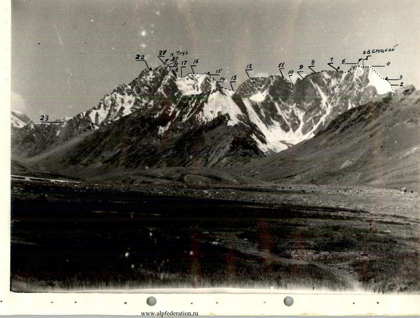
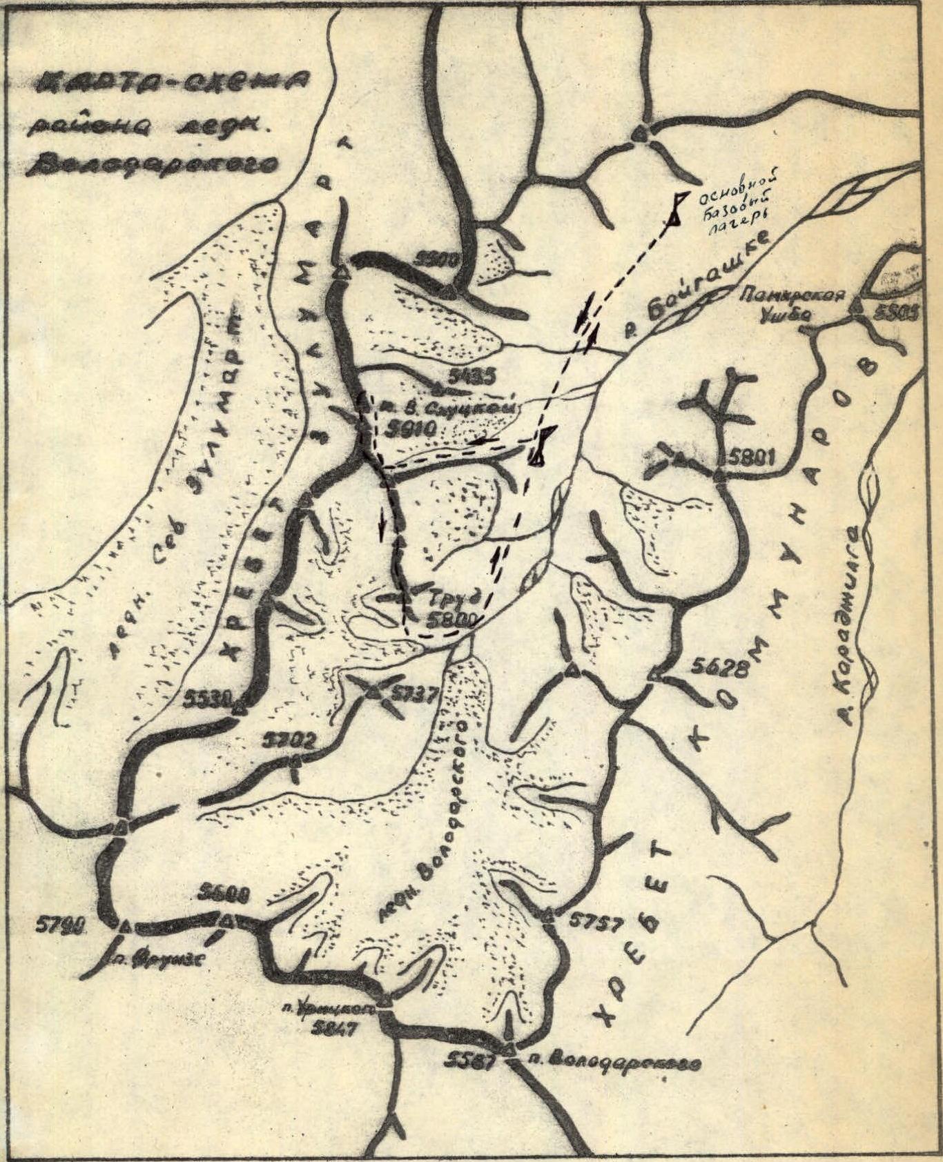
Peak V. Slutskoy (5910) is located in the Zulumart ridge (orographic scheme, fig. 1). From p. V. Slutskoy to the SE, a spur departs, in which peak "Trud" (5800 m) is located. In the ridge between p.p. "Trud" and V. Slutskoy, there are two unnamed peaks with a height of approximately 5600 m (photo 1 — panorama). All four peaks form a single (in sports terms) massif. The base camp was located under the glacier flowing from the eastern slopes of p. V. Slutskoy (fig. 1). The height of the base camp is 4200 m. Approach along the right (orographic) moraine, under the eastern slopes of peak V. Slutskoy and along them, movement along the glacier under the saddle between p. V. Slutskoy and the ridge going north. Time to approach — 3–3.5 h. A night's stay was organized on the glacier under the route.
Route Description
July 22, 1977. Departure at 6:00.
Section R0–R1
Climb to the saddle to the right of the route. Movement on ice (30°), covered with a thin layer of snow. Before reaching the saddle — a crevasse with unreliable bridges. On the saddle — deep snow. Section R0–R1 was passed in crampons.
Section R1–R2
From the saddle, movement under the black rock island, first on snow, which turns into ice with a steepness of 30°. Then movement along the rock island to the right of the route until it ends. 8 ice screws were hammered.
Section R2–R3
Above the rock island, movement traverse towards the "red" destroyed ridge. 40 m on steep ice, covered with dry snow. Then along the walls of the "red" ridge, movement on ice with a steepness of 40–45° under the lowering in the ridge (photo 2). Exit to the rocks is difficult due to steep ice. 40 steps were cut. The rocks of the ridge are highly destroyed, although technically not complex, they require careful belaying. Movement continues to a small "gendarme", which is passed head-on. Behind the "gendarme" — a hollow, where the first overnight stay was organized. 17 ice screws were hammered, including four ice augers. July 23, 1977.
Section R3–R4
This section represents a ridge of variable steepness (45–55°), which to the west is broken off by steep destroyed rocks, and to the east — a steep ice slope. Movement along this part of the ridge is dangerous due to the lack of possibility to organize reliable belaying. Therefore, this section was overcome along the border of ice and rocks, on ice. 15 ice screws were hammered.
Section R4–R5
Descent in a sportsmanlike manner for 40 m on highly destroyed rocks with a steepness of 50°. Very rockfall-prone.
Section R5–R6
Ascent along the ridge along the border of ice and rocks, on ice. This section leads to the summit of p. V. Slutskoy. No more than 2–3 people can be on the summit at the same time. 5 ice screws were hammered.
Section R6–R7
From the summit, descent along the ridge, which first goes south, then turns southwest. The rocks are highly destroyed. In some places: the rocks that make them up, due to their changes and weathering processes, are turned into scree. It is impossible to organize sufficiently reliable belaying. Belaying was carried out with ice screws, which were hammered into the rocks. 5 ice screws were hammered. (photo 3) After descending from this ridge — exit to the ridge, which goes to the SSE. This ridge has a lowering, above which a cornice hangs. Movement along the ridge — simultaneous. Before the cornice, a second overnight stay was organized near a "gendarme" in the form of a finger. July 24, 1977.
Section R7–R8
To exit this section, the cornice was cut through, and descent was carried out in a sportsmanlike manner for 40 m, with a steepness of 50°. Further movement along the ridge to the south — simultaneous until the "failure".
Section R8–R9
Descent into the first part of the "failure" to the west to the rock wall, filled with ice. Along this wall, descent by rappel on a double rope for 40 m to a sloping snow platform. (photo 4) From this platform, bypassing the "red" wall, descent to the south onto two wide snow shelves, which are located one below the other. Descent by climbing. 2 rock pitons were hammered.
Section R9–R10
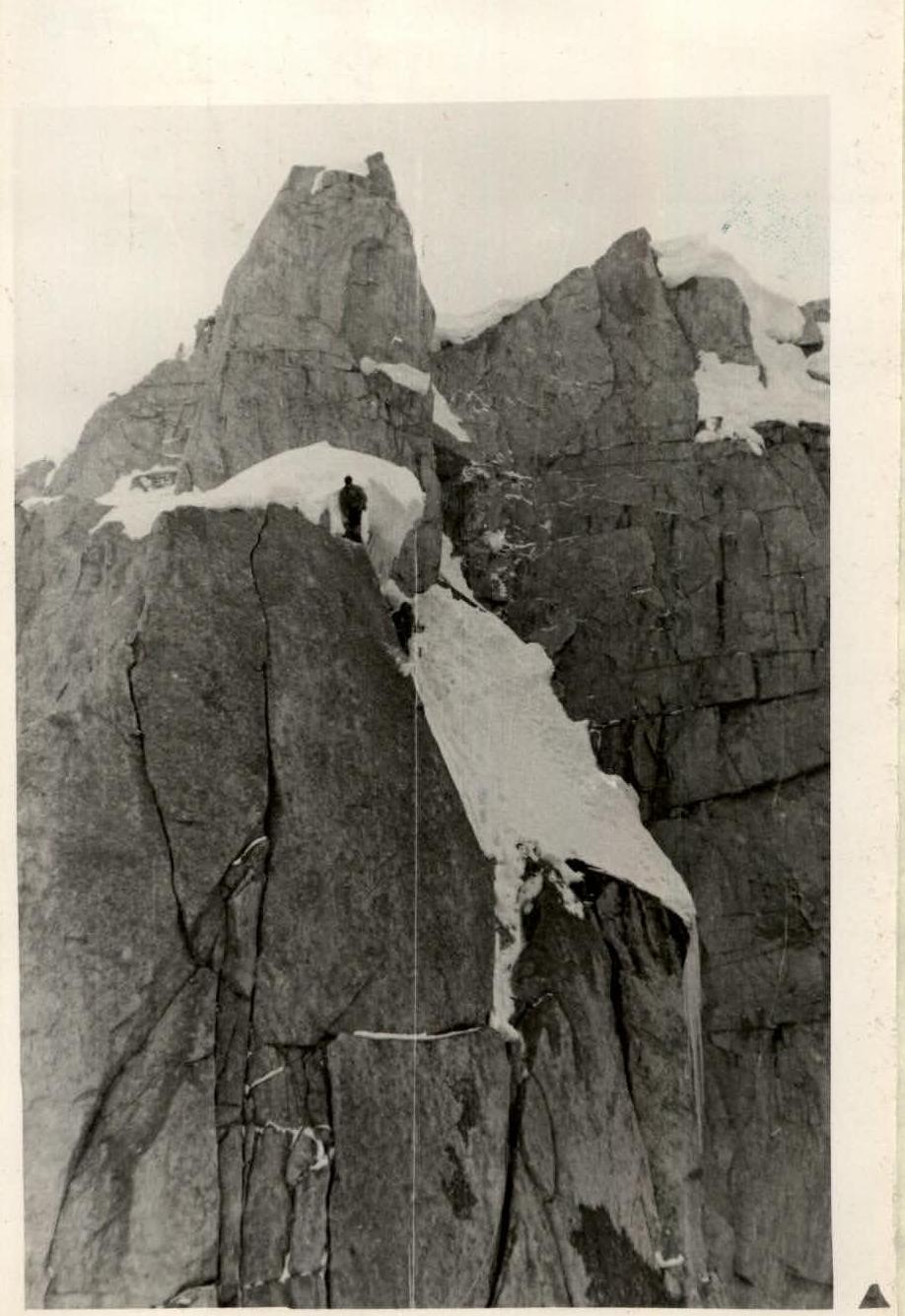
After the snow shelves, a wall with a steepness of 85–90°, from which a 30 m rappel (photo 5). After the rappel, descent along monolithic, but not steep rocks to a snow-ice couloir. Descent along the couloir was carried out in a sportsmanlike manner. The last one descended by climbing with lower belaying. After the couloir, movement along easy, smoothed rocks and a pronounced rock shelf. 10 rock pitons were hammered.
Section R10–R11
From the pronounced rock shelf, ascent onto a huge smoothed rock slab, ascent is carried out along the border of ice and snow, on ice with a steepness of 60° for 50 m. 2 ice and 2 rock pitons were hammered. After the slab, along ice with a steepness of 30° — exit under a 7-meter vertical wall, which is passed along a crack (photo 6). After the wall — movement along not steep ice to the right of the route — under a yellow 20-meter overhanging rock wall. Ice leads to steep, snow-covered rock slabs, along which — exit to the ridge of peak 5600 m. 5 more ice and 7 rock pitons were hammered.
Section R11–R12
The ridge is snow-covered, but not dangerous, movement is simultaneous, to characteristic large stone blocks. Then ascent for 40 m to the ridge, covered with large scree. Here, belaying was carried out using rock outcrops. Movement until smoothed rocks in the form of "feathers".
Section R12–R13
This section represents a ridge, which in the form of steps descends to the largest lowering in the traverse. The ridge is a series of smoothed rocks in the form of "feathers". Descent was carried out in a sportsmanlike manner. The last one went by climbing with lower belaying. Only on one section (20 m — photo 7) was a double rope used on the descent. Steepness of the rock walls of the ridge is 80°. Belaying through a ledge.
Section R13–R14
From the saddle to the second peak 5600 m, ascent strictly along the ridge, which consists of huge monolithic rock blocks. These blocks form steep, 3–4 m high, walls, which are often covered with ice. All this greatly complicates movement along the ridge. Belaying was carried out through a ledge. Steepness of the ridge on this section is approximately 50°.
Section R14–R15
This section is similar in character to the previous one. Before the summit, a "gendarme", which is passed to the left along a narrow ice shelf, crawling. Behind the "gendarme" — a good ice platform, on which the third overnight stay was organized. 2 rock pitons were hammered.
Section R15–R16
After the overnight stay:
- Ascent along a snow couloir to the summit (70 m).
- Descent along a not pronounced snow couloir into a failure (100 m).
- Exit to the ridge, consisting of rock blocks.
- Ascent along the ridge to a rise in the ridge. From this rise, a series of ridges departs to the west, which end in steep rock walls. It is necessary to descend along the ridge, which goes south, directly to the saddle.
Section R16–R17
The ridge is of variable steepness, i.e., represents a series of rock walls with chimneys and cracks. Descent by climbing, rocks are technically not difficult, belaying through ledges (photo 8).
Section R17–R18
From the saddle, ascent to p. "Trud", first movement in the direction of the rock outcrop, which is visible in photo 1 in the form of a spot. Movement along a not pronounced ridge with highly destroyed rocks.
Section R18–R19
Further movement along the "spot" along the border of ice and rocks, and then on ice with a steepness of 45–50° under a rock wall in the form of a triangle. 10 ice and 2 rock pitons were hammered.
Section R19–R20
Exit to a not pronounced edge in the left part of the triangular wall is complicated by ice. Rocks are monolithic, with a small number of holds. Steepness is 70°. 3 ice and 5 rock pitons were hammered.
Section R20–R21
After passing a 40-meter section of the rock wall, movement along an ice slope with a steepness of 50°, which leads to the summit of p. "Trud". The summit is a block in the form of a stump, into which a rock piton was hammered for a handrail. 2 rock and 5 ice pitons were hammered.
Section R21–R22
Descent from the summit to the west to the "shoulder", along a ridge with rocks of medium difficulty. From the "shoulder", a 30 m rappel to a 15-meter terrace with a width of 1.5 m. From the terrace, a 40 m rappel to the ridge of the sub-summit, steepness is 80°. 5 rock pitons were hammered. (photo 9) Fourth overnight stay on the sub-summit ridge.
Section R22–R23
From the sub-summit, descent along the western ridge to the glacier is quite complex and requires utmost attention. 5 rock pitons were hammered.
Main characteristics of the route
Route — traverse of p. V. Slutskoy (5910) — p. "Trud" (5800).
Height difference of the route
The total height difference from the base camp (4200) to the highest point of the traverse p. V. Slutskoy — 1710 m.
Height difference of the main sections
- Unnamed pass 4900 — p. V. Slutskoy (5910), ascent 1010 m.
- p. V. Slutskoy (5910) — failure 5500, descent 410 m.
- Failure 5500 — p. 5650, ascent 150 m.
- p. 5650 — failure 5200, descent 450 m.
- Failure 5200 — p. 5600, ascent 400 m.
- p. 5600 — saddle 5500, descent 150 L m.
- Saddle 5500 — p. "Trud" (5800), ascent 300 m.
- p. "Trud" (5800) — glacier (5000), descent 800 m.
The sum of the height differences along the route of the most complex sections is: ascent — 850 m, descent 1810 m.
Character of the section
| Date | Designation | Average steepness in degrees | Length in meters | Character of the section | Difficulty | Condition | Weather conditions | Rock | Ice | Bolt |
|---|---|---|---|---|---|---|---|---|---|---|
| July 22 | R0–R1 | 30 | 500 | Snow-ice slope, crevasses | I | Ice | Snow, sunny | – | – | – |
| 6:00–22:00 | R1–R2 | 30 | 350 | Ice slope | II | Ice | Wind | – | 8 | – |
| 10 h | R2–R3 | 40–45 | 300 | Ice, rock, exit to destroyed ridge | IV–V | Ice, snow | Wind | Ledge | 17 | – |
| July 23 | R3–R4 | 50 | 200 | Ice ridge | IV–V | Ice, snow | Frost | – | 15 | – |
| 8:00–21:00 | R4–R5 | 50 | 40 | Rockfall-prone couloir | V | Destroyed | Sunny | – | – | – |
| R5–R6 | 60 | 80 | Ice ridge | V | Ice | Sunny | – | 5 | – | |
| 9 h | R6–R7 | 50 | 200 | Ridge with highly destroyed rocks | IV–V | Rocks | Sunny | – | 5 | – |
| R7–R8 | 60 | 40 | Cornice, slope | IV | Snow | Overcast | Ledge | – | – | |
| July 24 | R8–R9 | 80 | 60 | Wall, rocks filled with ice | V | Ice, snow | Wind | 2 | – | – |
| 8:00–22:00 | R9–R10 | 70 | 100 | Wall, "ram's forehead", ice, couloir | IV–V | Ice | Rocks, wind | 10 | – | – |
| R10–R11 | 60 | 100 | Ice slope; walls, slabs | IV–V | Ice | Wind, snow | 9 | 7 | – | |
| 10 h | R11–R12 | 50 | Ridge, large scree | II | Rocks | Wind, snow | Ledge | – | – | |
| R12–R13 | 60 | 400 | Ridge, rocks like "feathers" | IV–V | Rocks | Good | 2, ledge | – | – | |
| R13–R14 | 50 | 200 | Ridge, from monolithic blocks | IV | Rocks | Good | Ledge | – | – | |
| R14–R15 | 50 | 150 | Ridge from blocks | III–IV | Rocks | Frost | 2, ledge | – | – | |
| July 25 | R15–R16 | 40 | 20 | Ridge of block structure | III | Rocks | Snow, wind | Ledge | – | – |
| 9:00–20:00 | R16–R17 | 40 | 100 | Ridge, rocks like "feathers" | III | Rocks | Snow, wind | Ledge | – | – |
| R17–R18 | 30 | 50 | Ridge, highly destroyed | II | Rocks | Snowfall | Ledge | – | – | |
| 8 h | R18–R19 | 50 | 100 | Ice slope | IV | Ice | Wind, snow | 2 | 10 | – |
| R19–R20 | 70 | 50 | Wall, monolithic | V | Ice | Wind, snow | 5 | 3 | – | |
| R20–R21 | 60 | 70 | Ice slope | V | Ice | Wind, snow | 2 | 5 | – | |
| R21–R22 | 80 | 70 | Wall, terraces | V | Rocks | Wind | 5 | – | – | |
| July 26 | R22–R23 | 40 | Rock ridge | IV–V | Rocks | Sunny | 5, ledge | – | – | |
| 9:00–18:00 | ||||||||||
| 6 h |
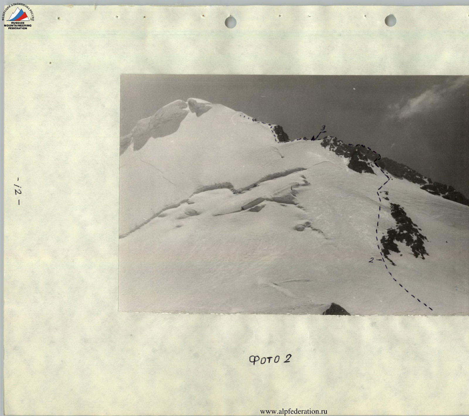
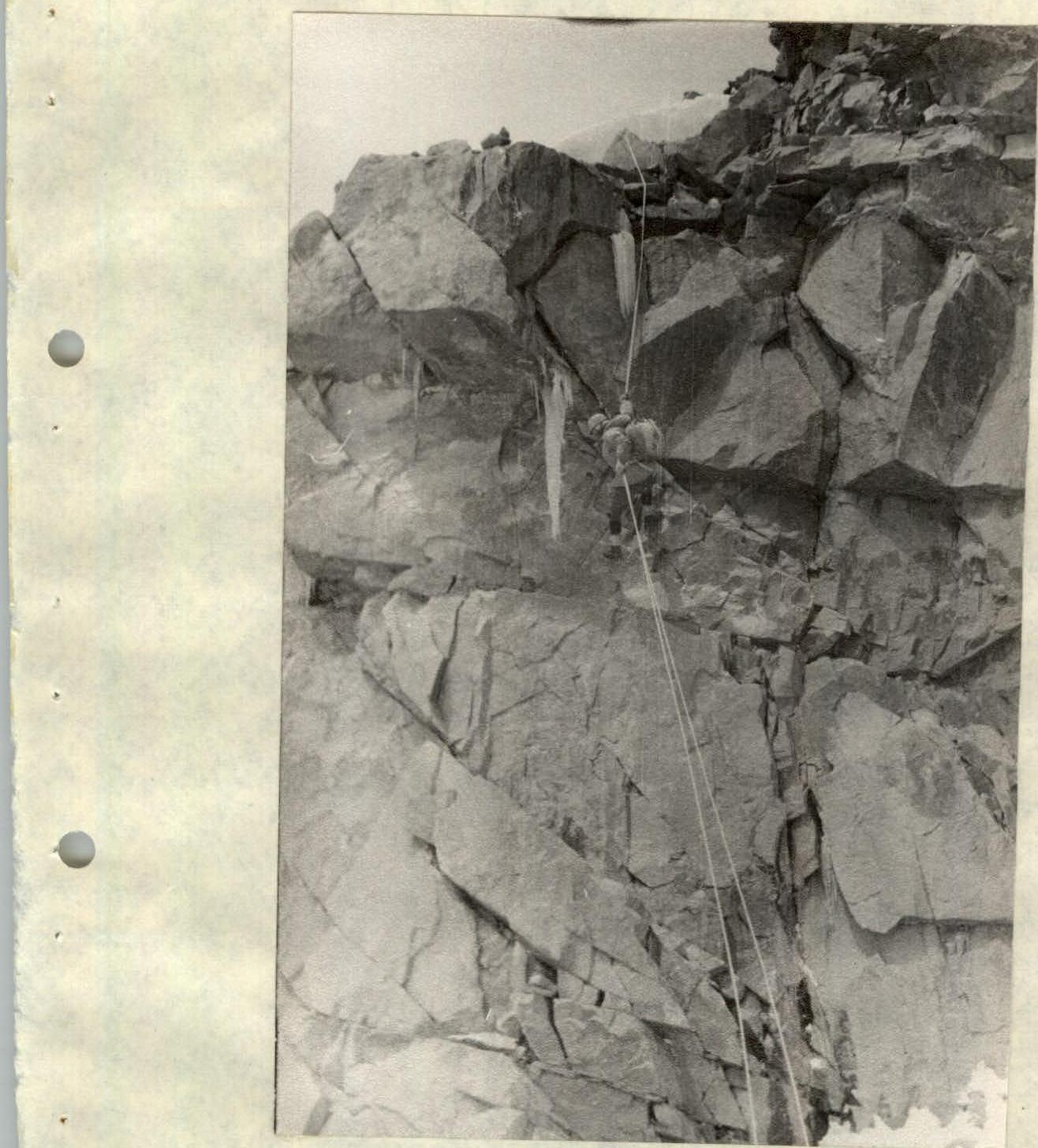 Photo 5
 — 19 —