PASSPORT
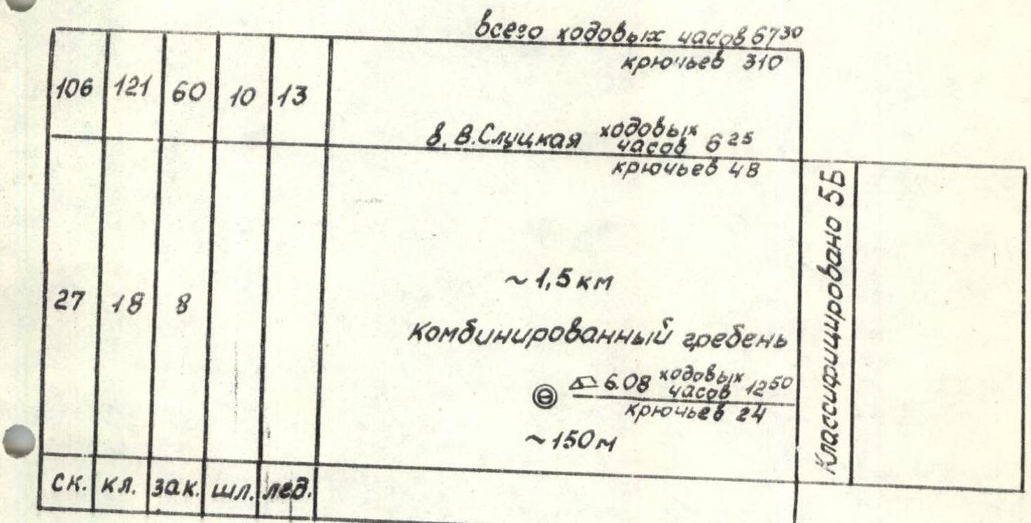
I. High-altitude technical class 2. Pamir, Zulumart ridge, Baygakshi gorge 3. Peak Slutskoy 5910 via the "pillar" on the wall 4. Proposed 6B first ascent 5. Wall section height difference is 1040 m, length is 1495 m, followed by a ridge 1.5-2 km. Length of sections with 5-6 difficulty category is 825 m, the summit ridge is classified as 5B. Average steepness of the lower part is 69° (4680-5210), upper part is 81° (5250-5720), including 6th category section at 90° (5280-5380); 80° (5480-5640). 6. Pitons used: rock 106, wedges 7; boxes 121, 5; chocks 60, 6; drill-in pitons 10, 8; ice screws 13, 3. 7. Team's total climbing hours: 67:30 and 6 days. 8. Overnights: 1, 2, 3, 5 - platforms on the snow-ice slope; 4 - platform built on the wall. 9. Team leader: Putintsev Alexander Vladimirovich, Master of Sports. Team members:
- Belenkov Pyotr Alekseyevich, Candidate for Master of Sports
- Valeev Nikolai Mikhailovich, Candidate for Master of Sports
- Ivanov Evgeny Petrovich, Candidate for Master of Sports
- Lobastov Valery Dmitrievich, Candidate for Master of Sports
- Pertziger Felix Izrailevich, Candidate for Master of Sports
- Popov Gennady Yakovlevich, Master of Sports
- Tsoy Vladimir, Candidate for Master of Sports.
- Coach: Elchibekov Vadim Ashotovich, Honored Coach of the Uzbek SSR.
- Departure to the route on August 1, 1983. Start of the ascent on August 2, 1983. Summit on August 7, 1983. Return on August 8, 1983.
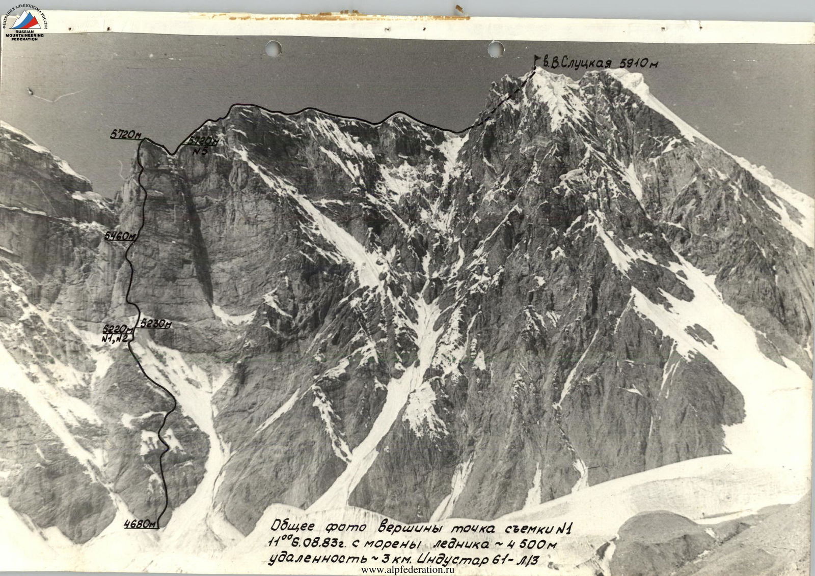
General photo of the summit. Shot taken from point #1, 11:00 on August 6, 1983, from the moraine of the glacier ~ 4500 m, distance 3 km. Industar 61–1/3.
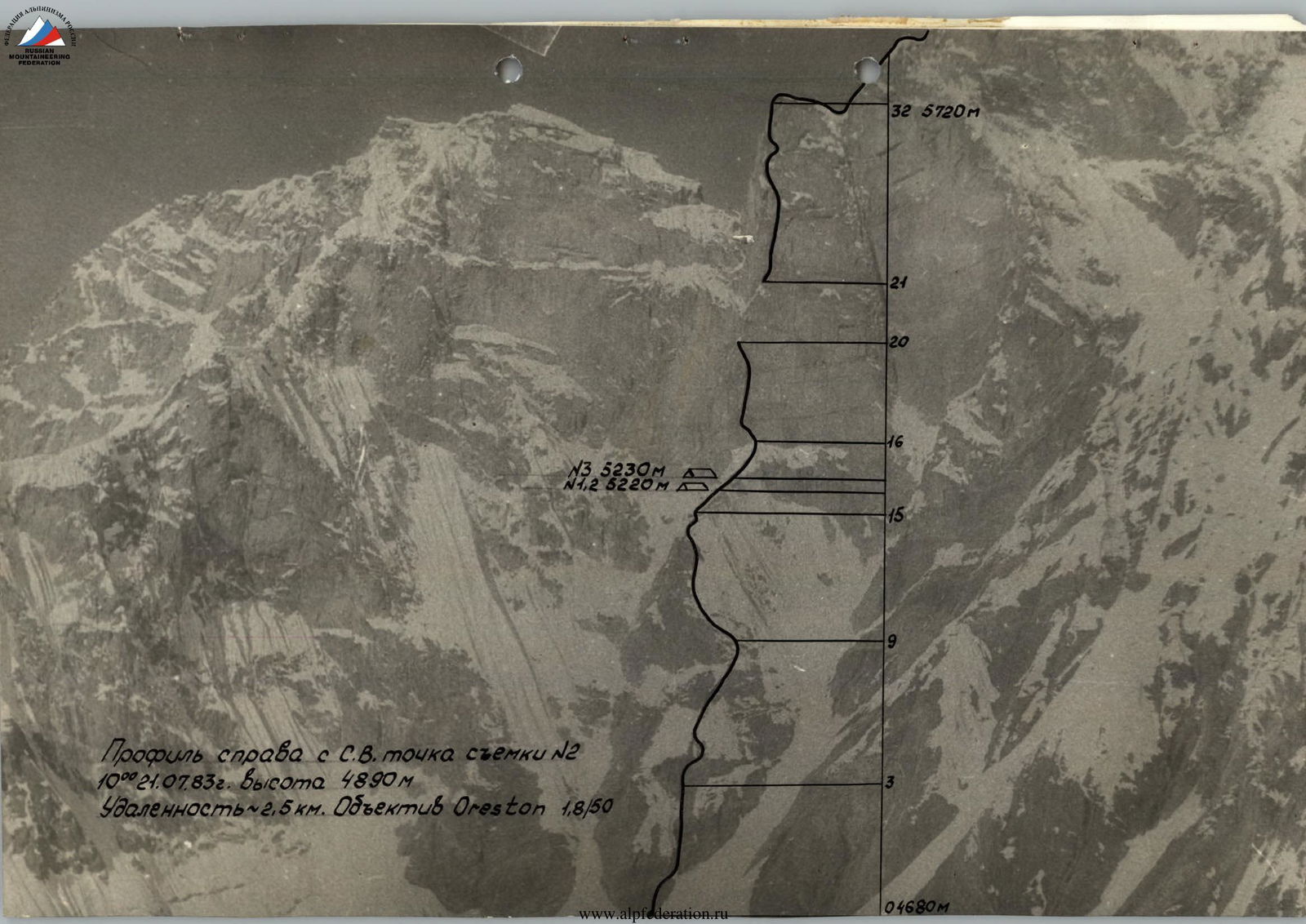
Profile from the right, from the NE. Shot taken from point #2, 10:00 on July 21, 1983. Height 4890 m. Distance ~2.5 km. Oreston 1.8/50 lens.
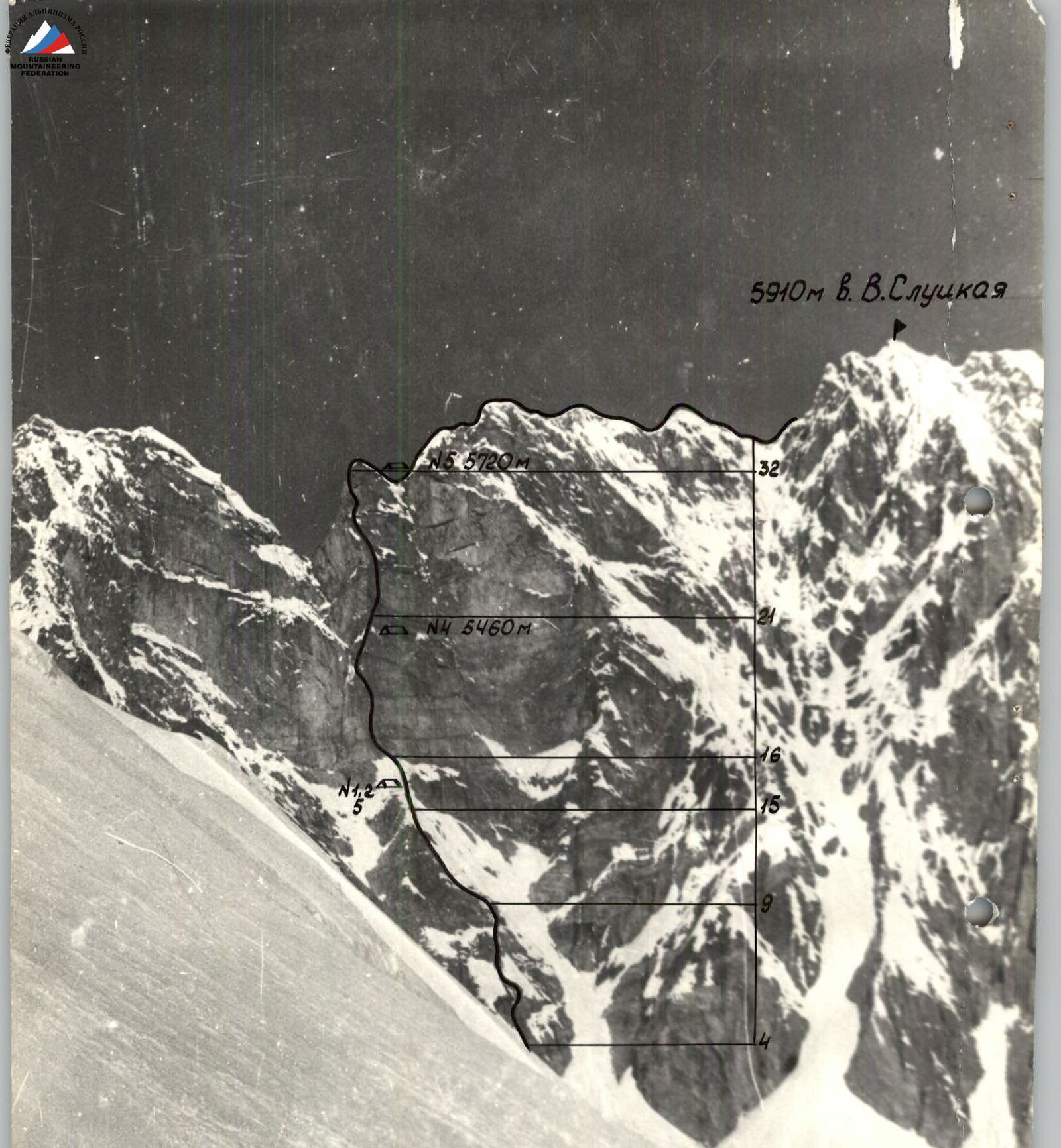
Profile from the left, from the ESE. Shot taken from point #3, 10:00 on July 21, 1983. Height 4920 m. Distance 2.5 km. T-43 4/4 lens.
Preparation for the Ascent
As previously reported, we saw Peak Slutskoy back in 1967, but we began considering it as a potential climb in 1982, after an expedition to this area by SCA-II climbers, from whom we obtained key characteristics and a photograph of the wall. Additionally, information about the peak was obtained from Kletsko K. and Dyachenko N.
To tackle a route of this nature, appropriate preparation is necessary. In addition to the team's regular training throughout the year following the system proposed by the coaches of the Himalayan expedition, during the immediate preparation period, the team completed:
- the traverse of Che-Guevara - SAGU;
- a wall route on Pamir Ushba (both 5B category).
They also successfully passed control standards (as can be confirmed by the championship judge Bragin O.V.).
After setting up the base, the team went to the wall in full strength to study and photograph the objective.
Although preliminary data indicated that the area is known for its excellent weather conditions (warm, snowless), this year was characterized by a significant amount of precipitation. The wall was quite snowy. However, we were warned (by Dyachenko N.) about the potential lack of water on the route. Upon examination, it became clear that the only viable path was along the "pillar" of the eastern wall, as the wall to the right and left was heavily exposed to rockfall. The upper part of the wall, specifically the "pillar," appeared to be extremely challenging technically. Thus, these findings (rockfall danger to the right and left, potential lack of water by the time of ascent, high technical complexity of the upper part, lack of visible overnight stops, and logical progression) largely determined the choice of route and tactics.
Challenging aspects included:
- a very rockfall-prone approach to the route, mitigated by an early, pre-sunrise approach to the wall;
- exposure of the lower part of the route to rockfall from the "lap" on the left from the overhanging wall, addressed by passing it to the right, beyond its most protruding part;
- high complexity of the upper part of the wall - the "pillar"; mitigated by prolonged processing from convenient overnight locations, with probable use of drill-in pitons.
Additionally, during the ascent period, a fully equipped rescue team was continuously present at the observers' camp and base, maintaining regular radio contact.

Tactical Actions of the Team
The team largely executed the tactical plan. Only the overnight stop on the "pillar" was organized lower than planned, due to the high complexity of the upper part of the "pillar" and the lack of suitable locations for a bivouac above. (Only at point 28 was an overnight stop possible, photo 13).
There was no fixed rope team composition on the route. Those working ahead were:
- Pertziger sections R0-R9, R20-R23, R26-R30
- Popov sections R9-R16
- Tsoy sections R15-R21, R22-R27
- Valeev sections R30-R32
- Lobastov sections R32-R33
Sections R16-R26 and part of R26-R27 were preliminarily processed.
On the route, they worked with fixed ropes on sections R0-R32 and partially on R32-R33.
First day - continuous work by the entire team until the establishment of a bivouac. Pertziger led, followed by Popov. The platform was carved into the snow-ice slope.
Second day - Tsoy - Lobastov processed the further route, Ivanov-Belenkov supplied the first pair with gear, the rest improved the bivouac.
Third day - Pertziger - Valeev went out to process. Popov - Putintsev carried gear, the rest moved the bivouac, freeing two ropes for further processing. A complete change of pairs working on processing, thus everyone rested for one day.
Fourth day - worked in full strength, all with backpacks:
- The pair with lighter backpacks went ahead to continue processing;
- Left gear near the pre-designated overnight location.
Having confirmed that there was no more convenient overnight location in the near future, the rest built a platform (4 hours), with insurance and attachment of 18 pitons. As ropes and pitons were freed from below, first Popov, then Putintsev carried gear to Tsoy and Lobastov working above. As on subsequent days, the transfer of gear along the chain from bottom to top as it became available was very well organized.
Fifth day - worked in full strength. Pertziger, Putintsev with lighter backpacks went ahead, at the end of the processed section, they combined two backpacks into one and continued working.
On the last two sections of the wall, the pair Valeev - Pertziger went ahead.
Sixth day - movement alternated between belaying and fixed rope climbing, typically with changing rope team compositions, except for Lobastov who consistently worked ahead. There were no falls or injuries during the ascent. The team's work was organized as follows:
- The first pair directly processed the route on nylon ropes, the second pair straightened the fixed ropes, removed unnecessary pitons, replaced ropes with capron ones, and carried gear for the first pair, the third pair carried the main load and transferred gear from the bottom to the upper pairs, the fourth pair removed pitons, collected gear, and transferred everything to the upper pairs; the composition of the pairs could change.
Thus, through coordinated work and precise execution of the tactical plan, all challenges posed by the route to the team were resolved.
On the route, the team used a 2IPN radio station, with no radio contact sessions missed.
Among the technical techniques and equipment used (pendulum, climbing on fixed ropes with a leg - harness with a suspended backpack, use of extensions, a cord for pulling out pitons, a small "Febus" in combination with a gas stove, chocks, boxes, etc.), perhaps the use of a "Volna" type tent and the mandatory replacement of fixed ropes with capron ones were entirely new, photo 11.
Unfortunately, photography on the route was significantly complicated by limited visibility, complexity, and lack of time (almost always everyone was simultaneously engaged in work).

Route Description by Sections
R0-R1. Sloping shelf - crack, destroyed. R1-R2. Photo 7. The beginning is flooded with water. R2-R3. In the middle of the section, a belt of destroyed overhanging rocks, very complex, 3-4 m. R4-R5. Couloir, crossed from left to right, then left along the right bank. R7-R8. Horizontal traverse to the right. R8-R9. Up to this section, they followed slates, above and until the end of the wall - granite. R9-R10. Snow-ice slope with rock outcrops, left - up. R10-R11. The section begins with a steep ice wall. R11-R12. Photo 8. R12-R13. The section is intersected by sheer walls with icicles. R13-R14. Traverse horizontally to the right under a more solid part of the cornice. R14-R15. Cornice. Stirrups. The top is a snow cushion, ice axe does not hold, which greatly complicated the passage. R15-R16. "Tables". Caution, cornices on the left and right. R16-R17. Crushed wall, fairly solid, traverse left-up. R17-R18. Destroyed cornice, under it horizontally left to its end. R18-R19. Large blocks-slabs, typically "ringing" (feeling hollow underneath), which greatly complicates progress and makes it difficult to choose cracks, fissures, and holds. Moreover, the upper part overhangs, and the fragmentation of blocks increases. Very cautious climbing. R19-R20. Sharp traverse left-up in the direction of a weakly expressed edge of the "pillar", the character of the rocks is the same, extremely cautious climbing. R20-R21. Destroyed, especially cautious passage for the entire team, in the lower part of the section, the danger of being hit by rocks and cornices from the wall to the left of the "pillar" disappears. The overnight stop is safe, under an overhanging though fragmented but solid wall. The very top of the section - photo 9. R21-R22. Very smooth but solid rocks, up, then traversing to the right. Photo 10 characterizes the rocks of the section. R22-R23. Blocks protruding like cornices, photo 10, 11 - "ring", due to which drill-in pitons had to be used, but overall the rocks are solid. R23-R24. Zone of fragmentation, destroyed small blocks. R24-R25. Smooth rocks, left-up towards hanging ice on slabs, start of the section - photo 12. R25-R26. Chimney between the wall and a detached slab. R26-R27. Smooth rocks with a fissure leading under a cornice and ending above it. From the upper point of the cornice - a pendulum to the right onto a smooth slab with tiny protrusions, two drill-in pitons to a crack (see additional diagram). An overnight stop is possible at the end of the section. Photo 13. R27-R28. Internal corner, abutting a roof. Photo 14. R28-R29. Traverse left along an absolutely smooth slab. Photo 14. R29-R30. Chimney with smooth walls without cracks. R30-R31. Sharp edge, which ends the left face of the continuing internal corner (section R27-R28). R31-R32. Right wall of the internal corner, leading to the summit of the "pillar". R32-R33. Combined corniced ridge: the first two pinnacles - granite, further - slates, very destroyed. The most complex part - the pre-summit ascent with a large number of pinnacles.
Descent via the northern edge.