Report
On the high-altitude traverse of Peak Oktyabrsky – Peak Lenin, with the ascent to Peak Oktyabrsky via the western edge, accomplished by the combined team of CSKA. Dedicated to the 30th anniversary of the ascent by the Red Army team to Peak Lenin in 1934.
The Trans-Alai Range, discovered in 1871 by the renowned explorer of Central Asia, A.P. Fedchenko, is one of the highest mountain ranges in the Pamir region. The highest part of the range is located in its center and forms a chain of peaks: Peak Lenin – 7134 m, Peak 6852 m, Peak Dzerzhinsky, Peak Kyzyl-Agyn, Peak Edinstva, and others. Peak Lenin is the third highest peak in the Soviet Union, the most popular "seven-thousander," and a high-altitude mountaineering stadium of the country. To the east of Peak Lenin, the Trans-Alai Range turns south and, in the area of Peak Edinstva, divides into two. The main range continues eastward, and a powerful, long Zulumart range with its highest point, Peak Oktyabrsky (6780 m), branches off to the south. The chain of peaks from Peak Oktyabrsky to Krylenko Pass was named "Mountains of Barricades" by N.V. Krylenko in 1928, which now includes: Oktyabrsky Peaks, Peak Edinstva, Peak 6350 m, and Peak 6104 m. Peak Oktyabrsky is a massif with three peaks: the South Peak, with an elevation of about 6750 m (this is the peak visible from the Kara-Jilgа valley), the Main Peak with an elevation of 6780 m, and the North Peak with an elevation of about 2270 m.
The elevation differences between the peaks reach 100–120 meters.
From Krylenko Pass to the south descends the powerful B. Sauk-Dara glacier, which is framed by steep slopes and walls of the surrounding peaks.
The area is very interesting for sports mountaineering, not only for high-altitude but also for technical climbing. The complexity of the routes can be judged by the fact that over 35 years since the beginning of the exploration of this area, despite a fairly large number of expeditions, not a single ascent has been made from the B. Sauk-Dara glacier to any peak, except for the classic route to Peak Lenin via the route of the first ascenders.
See the methodical collection "Peak Lenin" by V.I. Ratzek, 1960.
The CSKA combined team, having successfully climbed Peak Engels (6510 m) in 1963 via the most complex route from the southeast, set a goal for 1964 to ascend Peak Lenin in combination with a complex ascent to one of the peaks of the Zulumart range or the southern spur of Peak Lenin. This year marked the 30th anniversary of the first ascent by Soviet climbers (the Red Army team) to the peak named after the Great Leader.
Understanding the complexity of the task, the team, in addition to well-organized physical and technical training, devoted a lot of time to developing the route, familiarizing themselves with the area, and preparing equipment. Consultations with Honored Masters of Sports V.M. Abalakov, K.K. Kuzmin, Master of Sports S.M. Savvon, M. Greshnev, B. Romanov, and others showed that the ascent would require the team to be very well-prepared and make correct tactical decisions.
The team was formed by a decision of the CSKA section bureau, including only those athletes who participated in the 1963 assault on Peak Engels. The fact that the expedition was to last no more than 30 days placed higher demands on the participants' level of preparedness and health.
July 19. As in the previous year, the team is again in Osh. Preparations for departure are in full swing. Equipment arrived from Moscow and Tashkent. V.I. Ratzek, as the head of the expedition, methodically and calmly sets the entire mechanism of the expedition in motion. The final purchases of food are made, and the equipment is checked before the long journey. Senior coach I.V. Khin meticulously checks the physical and technical preparedness of the team members:
- 3000 m cross-country run,
- pull-ups,
- rope climbing,
- swimming,
- squats,
- rock climbing competitions on "Suleiman's Throne,"
- medical examination.
Conclusion: the combined team is well-prepared, and their health is excellent.
July 22. A caravan of cars stretches along the Pamir Highway. Taldyk Pass — and again, a majestic peak: a sight that is never forgotten. Overnight stay in the Alai Valley among green grass and warmth. This will not happen again for a month.
July 23. We manage to traverse the nearby peaks on the slope of the Alai Range in the first half of the day. The first days of acclimatization. Kyzyl-Art. Descent into the ominous Markansu — and now we are in Central Asia. A right turn into Kara-Jilga — and again, a return to Central Asia. From afar, we see a waving red flag — a Siberian expedition led by B.P. Soustin. Joyful greetings. Setting up a base camp. We see Peak Oktyabrsky for the first time.
July 24–26. First snow and ice training. First reconnaissance of the route to Profsoyuzov Pass. Preparation for the exit to the B. Sauk-Dara glacier.
July 27–28. Departure by a group of 15 people for an overnight stay at "4500 m" on the B. Sauk-Dara glacier.
July 28 – August 2. Setting up a 5000 m camp on the right (orographically) bank of the glacier. Reconnaissance of the route. Ascent to a height of about 6000 m along the southeastern edge of Peak 6852. Descent to the "4500 m" camp and return to the "4200 m" base camp via Profsoyuzov Pass.
August 3 – 7. Preparation for the traverse. Rest. Medical examination. Acclimatization is proceeding successfully. The final composition of the assault team is approved at the coaching council, consisting of 10 people.
| 1. Nekrasov V.P. | — MS | — leader |
|---|---|---|
| 2. Khivlyuk G.T. | — MS | — deputy leader |
| 3. Bitny A.V. | — MS | — participant |
| 4. Demchenko A.S. | — MS | -"- |
| 5. Logvinov V.I. | — MS | -"- |
| 6. Solodovnikov T.K. | 1st sports category | -"- |
| 7. Goryachev I.A. | 1st sports category | -"- |
| 8. Starosits E.V. | 1st sports category | -"- |
| 9. Kochetov V.I. | 1st sports category | -"- |
| 10. Tustukbaev A.K. | 1st sports category | -"- |
The equipment and food supplies are checked for the last time. A group led by MS V.A. Tikhonravov is accompanying us. This group will be stationed at the 5000 m camp on the Sauk-Dara glacier, ready to assist us in case of an emergency. The radio communication system is practiced:
- Communication between groups is ensured by VHF radio stations type R-126.
- Communication with base camps in Kara-Jilga and Achik-Tash — on HF radio stations.
- Radio communication is reinforced by signal flares.
Interaction is clarified with the groups led by MS B. Soustin and MS A. Romanov, who are to ascend Peak Lenin at the same time.
August 8. The day of departure for the assault. Everyone is lined up. A report is given to the head of the camp about the team's readiness to depart. At 10:00, farewell wishes and handshakes — and the column of climbers slowly moves along the trail of the Kok-Sai valley. The path goes along the right (orographically) moraine of the Oktyabrsky glacier to the turn towards Profsoyuzov Pass. At 16:00, we reach the pass and, after 2 hours, arrive at the 4500 m camp on the left (orographically) moraine of the B. Sauk-Dara glacier. The camp is equipped with tents, food, and fuel. We set up a radio station for communication with the base camp.
August 9. Departure from the "4500 m" camp at 10:00. We cross the glacier and move up along the "yellow" moraine to the 5000 m camp. The journey takes 4 hours. We set up tents. We sort out food and equipment. Tomorrow, we depart for the route.
The western edge of Peak Oktyabrsky is directly in front of us on the other side of the glacier. It rises from the glacier to a height of over 1.5 kilometers. The rocks are crumbling. The edge is divided into two parts in the middle by an ice bridge. It is unusual to see a rock route all the way to the top of the peak in this ice and snow country. Tomorrow, we will be the pioneers — making the first ascent to one of the highest peaks in this area via the edge from the B. Sauk-Dara glacier. The path ahead will be long and difficult. The experience gained last year working on the steep slopes of the southeastern edge of Peak Engels will help us. The weather is magnificent.
August 10. Early in the morning, we bid farewell to our friends and cross the glacier. We circumvent a frozen lake and begin the ascent along the crumbling rocks of the edge. To the right is an icy slope with traces of rockfall. Initially, a small traverse to the left, then up to the right along a chimney, we exit onto the edge, which is covered with scree, and move straight up. The edge ends at a ledge that goes left to a rock wall.
- The wall consists of large rocks and is climbed straight up.
- The sound of the first driven pitons.
- We exit onto a rock ledge.
- The steepness decreases to 40°.
- The ledge turns into a rock edge 3–4.
- The rocks are of medium difficulty, and insurance is provided through ledges.
- We approach a difficult rock wall 4–5.
- Insurance is provided by pitons.
- The wall turns into an inner corner, which is climbed fairly easily.
The pace of movement is high. The team is doing well. During the day, we establish radio contact with the group below. They report that we are visible. The couloir 6–7 is quite difficult. The rocks are icy, and we have to strengthen the piton insurance. We are climbing in crampons with trikonys attached. We get accustomed to the inconvenience of a free leg, and by mid-day, the guys are confidently working on the steepest sections. The general opinion is that crampons with trikonys can be used on almost all complex routes in the Pamir.
After the couloir, the path becomes easier again — we move along a rocky edge with reliable insurance through ledges. Above us to the left looms a wall — a gendarme, which we decide to bypass along a ledge and couloir to the right:
- First, straight up the wall.
- Then — a short ledge.
- We enter an ice-rock couloir, which is climbed with difficulty in its upper part.
- Insurance is provided by pitons.
After the couloir, we reach a ledge and move left-up along it to exit onto a rocky edge with scree. Ahead is a snow-ice bridge. The working day ends. Bivouac. Elevation 5700 m. We have climbed 600 m along the route in height today. The working day lasted 9 hours. 14 rock pitons and 3 ice pitons were driven. At 19:00, we establish radio contact. At 20:00, we have signal contact. Green flares are launched not only by us but also from the ridge of Peak Lenin. Everything is fine with everyone.
August 11. The night passed calmly. The sun warmed our bivouac. We departed at 10:00. Directly opposite is the magnificent southern spur of Peak Lenin with the beautiful Peak 6852. To the left and behind is a sea of peaks stretching to the horizon. In the center, the powerful massif of Peak Communism is visible. We begin moving straight up along the edge, then exit onto rocks, along which we climb to a platform before an icy rock wall rising 150 m. The only path is left-up along an icy couloir with protruding rocks, with an exit to a neighboring rocky edge that steeply rises. Careful insurance is provided. Movement slows down. The edge is climbed fairly easily, then again, we face an icy vertical wall. We decide to traverse left-up, three snow-ice couloirs. The couloirs are separated by rocky edges. Movement is carried out with great caution. Steepness increases. Elevation is over 6000 m. The weather starts to deteriorate. We stop on a sharp rocky edge. We carve out platforms in the ice and settle in for the night, half-sitting. The temperature drops at night. It snows. We eagerly await the morning.
August 12. In the morning, the sun is out again. Fresh snow. From the bivouac site, we cross a snow-ice couloir and exit onto an edge with characteristic rocky ledges — teeth R16. We move to the right along the edge via a couloir, then exit onto a bridge in the edge R17. Above us is a steep couloir covered in ice. Careful piton insurance is provided. We move up to the right, then left (in a spiral), and exit to a rock wall that is even steeper. The couloir and wall are among the key sections of the route. R19. Then follows a snow-ice slope with numerous rocky edges. Movement along the slope is left-up towards the middle of the edge that descends from the peak to the bridge. Elevation is over 6500 m. Careful insurance is provided. We exit onto the edge at 18:00. We decide to descend to the bridge. The descent takes 15 minutes. The place is convenient. Nearby is a frozen lake. The platforms are ready. This was the bivouac site of previous groups. Now we are on a route that has been climbed by climbers, and we know everything about the further days of our journey. We radio down the joyful news — the main section of the traverse, the western edge, is practically completed. Tomorrow, we will be on the summit. Today was the most difficult day of our journey, and the high altitude is taking its toll.
August 13. The bivouac on the bridge is good, despite the constantly blowing strong wind. We depart at 9:00. After 1.5 hours, we reach the summit. The edge is rocky, heavily covered with dry snow. We are on the North Oktyabrsky Peak, with an elevation of about 6750 m. The main peak of the massif is 2 hours away along the ridge. The path is not difficult. A gendarme on the ridge is bypassed to the right. At 13:00, we are on the highest point — Main Oktyabrsky, 6780 m. Ahead, further along the ridge, the third peak of the massif is visible — South Oktyabrsky, with an elevation of about 6750 m. From both peaks, we retrieve notes left by the Georgian expedition led by L.A. Akhvlediani in 1960. We return to the bivouac site at 16:30. We decide not to continue further, as tomorrow, according to the plan, we are to be on Krylenko Pass — a day's journey. Peak Oktyabrsky via the western edge took the group 3.5 days of work — 29 hours of climbing time — 30 rock pitons and 11 ice pitons were driven.
August 14. We depart from the bivouac site at 9:30. The ascent to Peak Edinstva goes along the southern edge. The edge is snow-ice with rock outcrops. At 11:30, we reach Peak Edinstva. We retrieve a note left by the Gruzalpklub. The descent goes along a broad ridge. Between Peak Edinstva and Krylenko Pass are three peaks: Peak 6350 m, Peak 6200 m, and Peak 6104 m (Peak "Spartak"). The ridge of peaks 6350 and 6200 is rocky, snow-covered, and of medium difficulty. Simultaneous insurance is provided. From Peak 6200 m, we retrieve a note left by the VTsSPS expedition. We descend to Peak 6104 m (Peak "Spartak"). At 19:00, we descend to Krylenko Pass — into the arms of our friends who ascended via the glacier. The group will coordinate with us on Peak Lenin.
August 15, 1964. Until 14:00 — rest. In the morning, the team led by S.I. Artyukhin departed to ascend to 6700 m and spend the night there. Yesterday, the group from the Turkestan Military District led by N.A. Snegirev ascended to 6100 m and spent the night there. We depart at 14:00. After 3 hours of ascent, we stop at an elevation of 6400 m for the night. Below, the evacuation of camps is underway. We will descend to the north. The base camp is being relocated from Kara-Jilga to Achik-Tash on the "onion meadow."
August 16. We depart at 8:30. Our well-being is good. Approaching the elevation of 6773 m, we see two ascending groups that departed the day before. At the final ascent to the summit of Peak Lenin, we catch up with our comrades. At 13:30, we reach the summit. Here it is — our cherished dream. Simultaneously, 25 army athletes stand on the peak. Leaving a traditional note in the cairn, we descend to the tents at 6400 m. The ascent to Peak Lenin from Krylenko Pass took the group 8 hours, at an average rate of about 170 m/h in elevation. We radio down the news of our success.
August 17. Departure at 8:00. We descend along the classic route from the north. Down the edge, then traverse left along the terrace, straight down to Lipkin's rock, and onto the Lenin glacier. V.I. Ratzek is already here. After 3 hours, we are on the "onion meadow," surrounded by flowers, fruits, and friends.
Conclusions:
- The traverse accomplished is a high-altitude traverse of great length (about 13 km) and height (from 6780 m to 7134 m).
- The traverse is a combined route, technically complex and high-altitude.
- The route of ascent to Peak Oktyabrsky via the western edge is technically complex and is rated 5B category of difficulty.
- The route via the western edge required 29 hours of climbing time. The entire traverse from base camp to base camp required 75 hours of climbing time.
- Meteorological conditions were mostly good.
- Insurance on the edge was mainly provided using rock and ice pitons. A total of 30 rock pitons and 11 ice pitons were driven during the ascent.
- There were no injuries, bruises, or falls within the group during the ascent.
- The traverse required flexible tactical and organizational decisions. All parts of the expedition worked well.
- The daily ration (dry products) averaged 800 g per person.
- The team is capable of undertaking ascents to even higher peaks via complex routes in the future.
Team Captain, Master of Sports of the USSR Nekrasov October 12, 1964
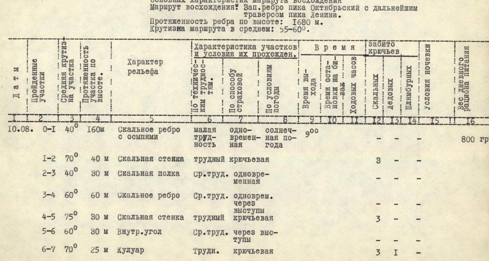
Table of Main Characteristics of the Ascent Route
Ascent Route: Western edge of Peak Oktyabrsky with further traverse of Peak Lenin. Height of the edge: 1680 m. Average steepness of the route: 55–60°.
| Dates | Sections Traversed | Average Steepness of Section | Height Gain of Section | Character of Relief | Characteristics of Sections and Conditions of Passage | Departure Time | Stop Time for Overnight Stay | Climbing Hours | Rock Pitons Driven | Ice Pitons Driven | Shoulder Pitons Driven | Overnight Stay Conditions | Base Camp Elevation |
|---|---|---|---|---|---|---|---|---|---|---|---|---|---|
| Technical Difficulty Level | Insurance Method | Weather Conditions | |||||||||||
| 10.08 | R0–R1 | 40° | 160 m | Rocky edge with scree | Low difficulty | Simultaneous | Sunny weather | 9:00 | |||||
| R1–R2 | 70° | 40 m | Rocky wall | Difficult | Piton insurance | 3 | |||||||
| R2–R3 | 40° | 30 m | Rocky ledge | Medium difficulty | Simultaneous | ||||||||
| R3–R4 | 60° | 60 m | Rocky edge | Medium difficulty | Simultaneous, via ledges | ||||||||
| R4–R5 | 75° | 30 m | Rocky wall | Difficult | Piton insurance | 3 | |||||||
| R5–R6 | 60° | 30 m | Inner corner | Medium difficulty | Via ledges | ||||||||
| R6–R7 | 70° | 25 m | Couloir | Difficult | Piton insurance | 3 | 1 | ||||||
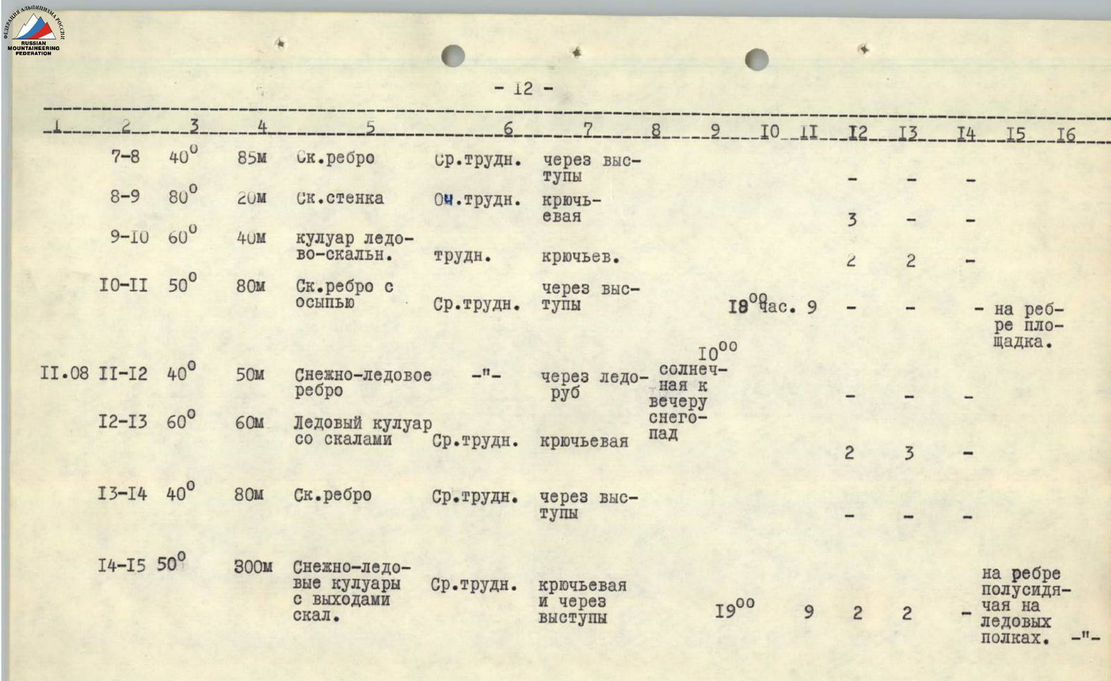
| R7–R8 | 40° | 85 m | Rocky edge | Medium difficulty | Via ledges | ||||||||
| R8–R9 | 80° | 20 m | Rocky wall | Very difficult | Piton insurance | 3 | |||||||
| R9–R10 | 60° | 40 m | Ice-rock couloir | Difficult | Piton insurance | 2 | 2 | ||||||
| R10–R11 | 50° | 80 m | Rocky edge with scree | Medium difficulty | Via ledges | 18:00 | 9 | On the edge, platform | |||||
| 11.08 | R11–R12 | 40° | 50 m | Snow-ice edge | Via ice axe | Sunny, with snowfall later | |||||||
| R12–R13 | 60° | 60 m | Icy couloir with rocks | Medium difficulty | Piton insurance | Snowfall | 2 | 3 | |||||
| R13–R14 | 40° | 80 m | Rocky edge | Medium difficulty | Via ledges | ||||||||
| R14–R15 | 50° | 300 m | Snow-ice couloirs with rock outcrops | Medium difficulty | Piton insurance and via ledges | 19:00 | 9 | 2 | 2 | On the edge, semi-sitting on ice ledges | |||
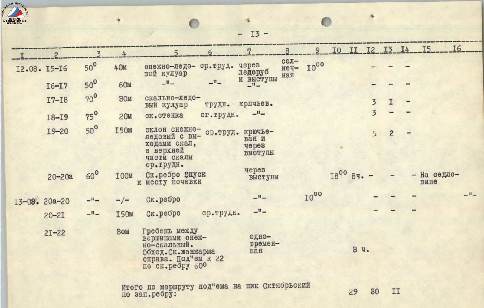
| 12.08 | R15–R16 | 50° | 40 m | Snow-ice couloir | Medium difficulty | Via ice axe and ledges | Sunny | 10:00 | |||||
| R16–R17 | 50° | 60 m | |||||||||||
| R17–R18 | 70° | 30 m | Ice-rock couloir | Difficult | Piton insurance | 3 | 1 | ||||||
| R18–R19 | 75° | 20 m | Rocky wall | Extreme difficulty | 3 | ||||||||
| R19–R20 | 50° | 150 m | Snow-ice slope with rock outcrops, with rocky sections of medium difficulty in the upper part | Medium difficulty | Piton insurance and via ledges | 5 | 2 | ||||||
| R20–R20a | 60° | 100 m | Rocky edge (descent to bivouac site) | Via ledges | 18:00 | 8 hours | On the saddle | ||||||
| 13.08 | R20a–R20 | Rocky edge | 10:00 | ||||||||||
| R20–R21 | 150 m | Rocky edge | Medium difficulty | ||||||||||
| R21–R22 | 30 m | Ridge between peaks, snow-rocky. Bypass of rocky gendarme to the right. Ascent to R22 along a rocky edge 60° | Simultaneous | 3 hours | |||||||||
| Total for the ascent route to Peak Oktyabrsky via the western edge: | 29 | 30 | 11 | ||||||||||
| 14.08 | 22–20a | Descent to the bivouac site on the saddle between Peak Oktyabrsky and Peak Edinstva | 16:30 | 3.5 hours | On the saddle | ||||||||
| 50° | Ascent to Peak Edinstva along a rocky-snowy edge | Medium difficulty | Via ice axe and ledges | Sunny, windy | 9:30 | 19:00 | 9.5 hours | ||||||
| Descent to the saddle between Peak Edinstva and Peak 6350 m. Ascent to Peak 6350 m, traverse of the ridge, and descent to Peak 6104 m (angular), then descent to Krylenko Pass. The most technically complex part of this path is the passage of Peak 6350 m. | |||||||||||||
| 15.08 | Ascent to Peak Lenin from Krylenko Pass is well-known and proceeds along the eastern ridge through elevations 6100–6504 m, 6773 m. Classified as 5A category of difficulty. | 3 hours | On the ridge at 6500 m | ||||||||||
| 16.08 | Ascent to Peak Lenin took the group 8 hours | Sunny | Storm in the second half | 8:30 | 13:30 (on the summit) | On the ridge at 6500 m | |||||||
| 17.08 | Descent proceeded via elevation 6500 m along the northern edge ("terrace" and "Lipkin's rock") onto the Lenin glacier | 7 hours 30 minutes | At the base camp "onion meadow" |
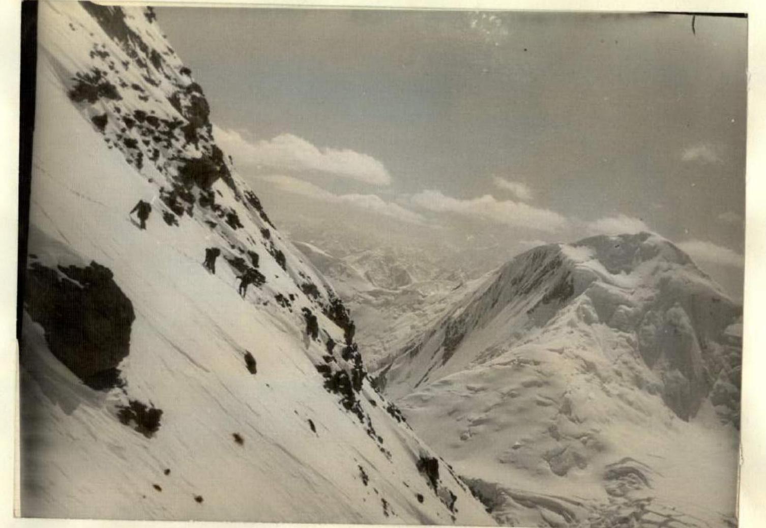
Crossing the upper section of the route from R19 to R20.

Ridge between the North and Main Oktyabrsky Peaks.

Oktyabrsky Peaks from Peak Edinstva. (part of the route is shown with a dotted line)
August 13, 1960. The assault group of the Georgian expedition, which ascended Peak Oktyabrsky and traversed from Profsoyuzov Pass, consisted of:
- Akhvlediani L.A. (leader)
- Akhvlediani E.
- Kerchiani B.
- Gabitashvili V.
- Medzmariashvili Sh.
- Kupatadze M.
- Gupava D.
- Guchava S.
- Beradze D.
- Damaev D.
- Kadagidze A.
- Akhvlediani A.A.
