
To the championship of the country in the class of high-altitude and technical ascents.
Report
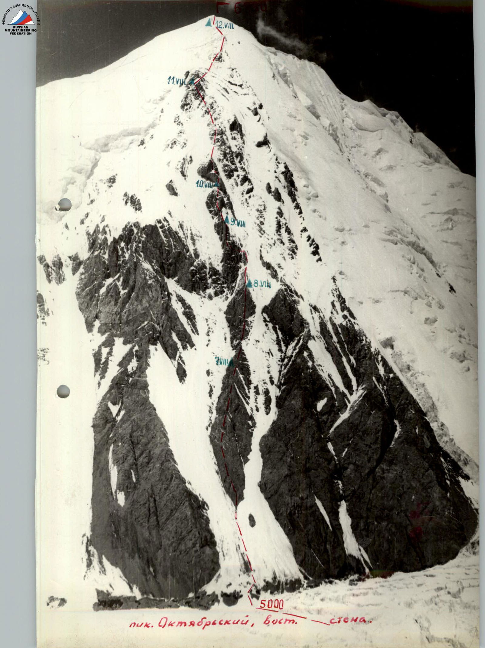
On the ascent of Peak Oktyabrsky 6780 m via the eastern wall from the Oktyabrsky glacier.
Team of the Central Council of the Gantiadi Sports Society
TBILISI
1970
List of participants of the 1970 USSR Alpine Championship of the Central Council of the Gantiadi Sports Society team
| №№ | Full Name | Year of Birth | Position in Expedition | Rank | Primary Occupation (Profession) | Party Membership | Nationality | Home Address | a) Best Ascent and Year. b) Best Ascents over the Last 2 Years. |
|---|---|---|---|---|---|---|---|---|---|
| 1 | 2 | 3 | 4 | 5 | 6 | 7 | 8 | 9 | 10 |
| 1. | Sharashenidze Dmitry Borisovich | 1937 | Captain | MS | Engineer | Non-party | Georgian | Tbilisi, Makharadze St., 23, apt. 5 | a) Ascent to Central Djangi-Tau - 1965, 6A. b) Kokyurtly-5A, traverse of Shkhieldy - 5B |
| 2. | Giutashvili Roman Ivanovich | 1937 | Deputy Captain | MS | Leading Engineer | Non-party | Georgian | Tbilisi, Digomi mass., 6/4, apt. 11 | a) Chatyn via E. wall - 1965, 5B. b) Tutyu-Bashi - 5B, Chatyn via E. wall - 5B |
| 3. | Tserediani Givi Iosifovich | 1928 | Participant | MS | Teacher | Non-party | Georgian | Mestia, Becho | a) "Mirror" Ushba - 1964, 6A. b) Ushba 4B |
| 4. | Berishvili Tengiz Akakievich | 1939 | Participant | CMS | Engineer | Non-party | Georgian | Tbilisi, GlDanskaya, №4, apt. 3 | a) S. wall of Central Djangi - 1965, 6A. b) Traverse of Shkhieldy - 5B, Kokyurtly - 5A |
| 5. | Nemsitsveridze Nazim Vladimirovich | 1947 | Participant | CMS | Student | Non-party | Georgian | Kutaisi, Lenin St., 52, apt. 4 | a) Kokyurtly - 5B. b) Kokyurtly - 5B, traverse of Shkhieldy - 5B |
Overview of the Ascent Area
The Zulu-Mart valley is adjacent to the powerful chain of the Trans-Alai range in the area of Peak Edintsva from the south, with its highest point - Peak Oktyabrsky - 6780 m.
Peak Oktyabrsky has three peaks:
- the southern one with a height of 6750 m (clearly visible from the Kara-Jilga valley),
- the main one with a height of 6780 m,
- the northern one with a height of about 6750 m.
This area has long been inhabited by climbers, but nevertheless, not a single ascent to Peak Oktyabrsky has been made from the side of the Oktyabrsky glacier.
In 1960, during the traverse of the Zulu-Mart ridge, a team from the Georgian Alpine Club made an ascent to Peak Oktyabrsky via the southwestern snow ridge.
In 1964, a combined team of the ЦСКА made an ascent to Peak Oktyabrsky via the western ridge from the B.Sauk-Dara glacier, followed by a traverse of Peak Oktyabrsky - Peak Lenin. They noted the technical complexity of the western slopes of the massif, but the most difficult path to Peak Oktyabrsky was the unclimbed eastern wall.
To the east, the Peak Oktyabrsky massif drops off with rocky bastions, interspersed with snow and ice couloirs, and to the northeast - with ice and snow slopes with huge overhanging "pillows". The western slopes are predominantly snow and ice with rocky outcrops, and only from the saddle between Peak Oktyabrsky and Peak Edintsva does a solid rocky counterfort extend.
On the eastern part of the wall, the central narrow counterfort, which leads to the pre-summit ridge of the southern peak, is of particular interest as a logical and objectively safe route. Above the left wide counterfort, ice slabs overhang in the upper part, and the right counterforts, starting from the middle part, are prone to avalanches. The central counterfort was the goal of the 1970 expedition.
The Kara-Jilga valley is convenient for setting up a relatively high base camp at an altitude of 4200 m, which is accessible by car. This eliminates the need for additional caravans and minimizes the number of intermediate bases.
The usually stable good weather and relatively high air temperature in this area quickly clear the slopes. The danger of snow avalanches exists in the central part of the route only when precipitation falls.
The altitude difference of the route reaches 1800 m, and throughout this part, the organization of bivouacs presents great difficulties.
Organizational and Tactical Plan of the Ascent
The organizational plan provided for the arrival of the expedition in Osh on July 8-10, transportation by car to the Kara-Jilga valley, and the establishment of a base camp at an altitude of 4200 m at the end of the Oktyabrsky glacier tongue on July 10-12. The acclimatization and training period was from July 12 to 25, including the organization of an intermediate camp at an altitude of 4500 m under the Profsouzyov pass, both in case the group took the reserve route and to facilitate shuttle trips when organizing a storm camp at an altitude of 4950 m.
The period from July 25 to August 5 was allocated for reconnaissance of approaches and descent from the summit, detailed observation of the wall at different times of day, approximate determination of bivouac sites, and processing of the lower part of the wall.
The ascent was scheduled to begin in the first decade of August. The expedition's evacuation was planned for the third decade of August.
All these plans were fulfilled by the team. On July 12, the expedition was fully assembled in the Kara-Jilga valley and set up a base camp.
On July 12-13, a hydroelectric station was established to power the VHF radio station for communication with Osh, the "Vysochnik" airfield, and to electrify the base camp in Kara-Jilga. A bridge was built to cross the right tributary of the Koy-Su river. On July 15, an intermediate camp was organized at an altitude of 4500 m under the Profsouzyov pass. From July 12 to 24, a storm camp was organized at an altitude of 4950 m, where the main supply of food and equipment was stored, and a reconnaissance of the approach paths under the wall was carried out.
On July 27, the storm group, observation and rescue teams, and a doctor headed to the storm camp at 4950 m.
On July 28-29, the group:
- replenished the supplies in the storm camp,
- observed the declared route from the slopes of Kyzyl-Agyn,
- spent the night at an altitude of 6450-6500 m for acclimatization and returned to the storm camp.
On July 29-30, observations were made of the wall's regime at different times of day. On July 31, the group processed the lower part of the route - about 400 m - and descended to the base camp in Kara-Jilga.
The tactical plan for the ascent was largely clear even before the team departed for the mountains. After being adjusted based on observations and route processing during preliminary exits, it looked as follows: the entire route was conditionally divided into three parts:
- First part - about 600 m vertically (up to the ice avalanche-prone couloir) - represents a clearly defined steep counterfort with individual sheer sections. The rock in the lower part is destroyed shale, significantly complicating the work.
- Second part - from the couloir to a clearly defined triangular black gendarme with monolithic bastions, about 400-450 m vertically - presented the main technical difficulty of the route.
The third part is a vaguely defined counterfort with icy rocks, about 600-650 m vertically. Throughout the entire route, organizing bivouacs is extremely challenging. Therefore, a very early exit from bivouacs is necessary (this is facilitated by the early illumination of the wall by the sun) to ensure a large reserve of daylight. The icing of the upper part of the route and the presence of ice sections in the central part necessitate the use of crampons by all team members.
The considerable length and complexity of the route require:
- frequent changes of the lead climber with a maximally lightened rucksack or without one;
- rational selection of equipment;
- a minimal-weight, high-calorie diet.
The technical complexity of the route and the limited possibility of organizing bivouac sites force the team to be configured for one tent, taking into account the need to distribute the load of the lead climber among the other team members.
An optimal group size is five people - a pair processes the route, and a trio acts as "load carriers".
On August 2, the coaching council refined and adjusted the ascent plan, approved the ascent route, and finalized the team composition.
The plan for the route's progression day by day was as follows:
- Day I - exit to the counterfort and passage of the previously processed part to the bivouac site;
- Day II - proceed to the beginning of the couloir;
- Day III - exit to the black bastion;
- Day IV - proceed to the triangular gendarme;
- Day V - pass the gendarme and exit to the icy rocks;
- Day VI - traverse the pre-summit, vaguely defined counterfort;
- Day VII - reach the summit and begin descent;
- Day VIII - descent was planned via the well-scouted snow southern ridge and further down a wide couloir to the Oktyabrsky glacier.
- Days IX-X - reserve days.
To additionally ensure the safety and observation of the storm group after it exited onto the pre-summit ridge, the observation and rescue group was to ascend via the southern ridge to meet them.
The execution of the tactical plan did not require significant changes. The correctness of the time allocation for passing the route sections and the approximate assessment of the difficulty were confirmed.
Route Processing
On July 31 at 5:00, a group consisting of:
- D. SHARASHENIDZE
- R. GIUTASHVILI
- G. TSEREDIANI
- N. NEMSICTVERIDZE
left the storm camp at 4950 m, located within 1.5 hours' walk from the base of the wall, to process the route. They crossed the heavily crevassed glacier and approached the base of the wall at 6:30.
They traversed the bergschrund (R0–R1) with piton belay through ice screws. Then, about 4 ropes of 40° firn slope (R1–R2). Belay through ice axe. In the upper part, under a thin layer of snow, ice appears, and belay is through ice screws. They exited onto destroyed rocks. The rock is soft, shale.
Movement:
- Alternating ascent up to the ridge, 1 rope (R2–R3). Rocks are easy, destroyed.
- Along the ridge to the left and upwards, two ropes of easy climbing on 45° rocks (R3–R4). Belay through outcrops.
- Further up the steep rocky ridge with a slope of 65° (R4–R5) directly upwards, climbing of medium difficulty. Piton belay, 1 rope.
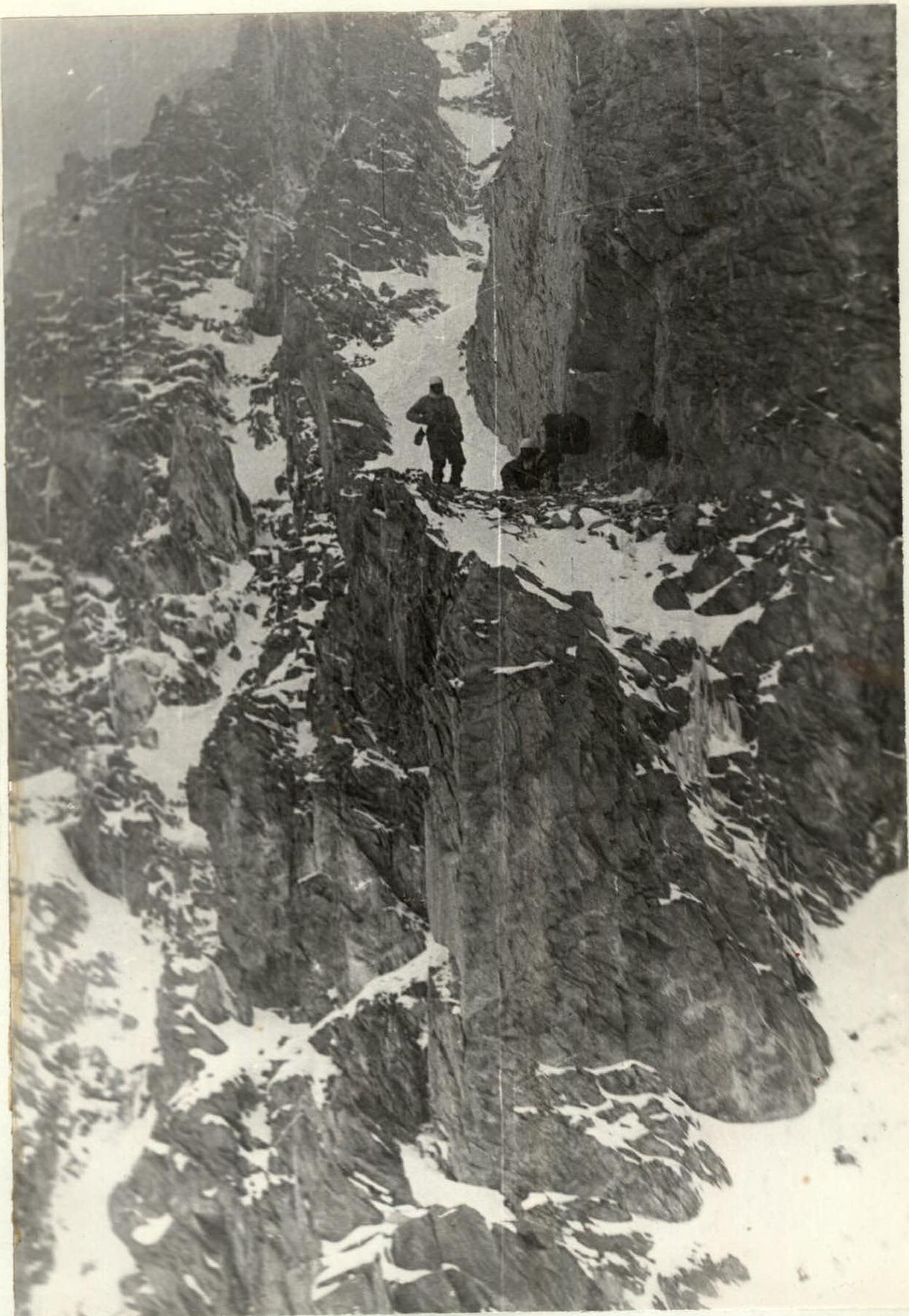
- Exit to 45° talus shelves (R5–R6) and left 1.5 ropes under 65° 1st wall (R6–R7), 1.5 ropes; climbing is difficult, piton belay, rocks are destroyed.
Further up the 80° internal corner (R7–R8) directly upwards, difficult climbing 0.5 ropes, piton belay. Then, exit to a steep but wide 60° ridge (R8–R9) 1.0 rope; rocks of medium difficulty. Exit under the second wall with a slope of 75° directly upwards, two ropes (R9–R10). Rocks are difficult, "tile-like" structure. Piton belay.
After the wall, left and upwards along the 55° ridge (R10–R11). One rope. Rocks of medium difficulty. Piton belay. Exit under the internal corner (R11–R12) with a slope of 75°. About 1 rope. Climbing is difficult, rocks are smooth. Rucksacks are pulled up. Weather worsens. We descend. Descent to the foot of the wall took 3 hours. Crossing the glacier, they marked the path and at 20:00, the group descended to the storm camp. About 130–140 m of rope was fixed. Processing took 10 working hours. 27 rock and 4 ice pitons were hammered.
The weather deteriorated completely. It was decided to wait it out in the base camp at Kara-Jilga.
Ascent Description
After two days of good weather, on August 4, the group consisting of D. Sharashenidze, R. Giutashvili, G. Tserediani, T. Berishvili, and N. Nemsitsveridze, along with the observation and rescue team consisting of N. Bakradze, V. Bakradze, G. Rostomashvili, G. Nanumova, and doctor V. Gvelesiani, left the base camp and reached the storm camp at 4950 m on August 5.
August 6 - rest and preparation for the ascent.
August 7 - the weather is good in the morning. At 5:00, the storm group left the camp. Thanks to the marked path, by 6:10, they were already under the wall. They quickly traversed the firn slope and easy rocks. The fixed ropes ensured a good pace upward. At 14:30, they were on the ledge where the cache was left. It was snowing. They decided to bivouac here. They unpacked the cache and spent 2 hours making a makeshift platform. The tent was only half accommodated. The bivouac was in a sitting position. At 19:00, they made the first radio contact with the storm camp. At 21:00, they sent a flare for the base camp. In the fog, the response signal was not visible.
August 8 - windy in the morning. Rocks were snow-covered. They departed at 7:00, leaving the first control tur on the bivouac. The Tserediani-Sharashe-nidze team led forward. Up the destroyed rocks with a slope of 60° directly upwards, 2.5 ropes (R12–R13). Piton belay and outcrops. Climbing of medium difficulty. Then directly upwards along 55° ledges, 2.5 ropes (R13–R14). Piton belay and outcrops. 2-3 meter wall sections were encountered. Climbing of medium difficulty. They exited onto a snow-covered ledge. Further up the internal corner with a slope of 80°–85°, 1 rope with many cracks and holds (R14–R15). The first climber went without a rucksack. Rucksacks were pulled up to a ledge that accommodated 2 people. Climbing is difficult. Piton belay. Further, 2.5 ropes along rocks of similar structure but with a lesser slope of 75° (R15–R16). Ahead, a bivouac site was visible through 1 rope. Already at 17:00. They moved along the ledge towards the ridge (1 rope on 60° rocks). Climbing of medium difficulty. They set up a bivouac at 17:30 (R16–R17). Bivouac conditions were satisfactory. The Berishvili-Nemsitsveridze team fixed 2 ropes of belay along a sharp 45° ridge to an avalanche-safe location at the mouth of the couloir (R17–R18). It snowed at night. They had to frequently shake snow off the tent. More than 40 cm of snow fell.
August 9 - wake-up at 3:00. Departure at 4:30. Unusually early for a high-altitude ascent. Overcast. Along the fixed ropes, they quickly exited to the ridge. They moved at a good pace; it was necessary to cross the couloir as early as possible. To the mouth of the couloir, there were still 1.5 ropes along a steep ridgecrest. At 6:30, they began to traverse the couloir in its upper part. On the ridge, a second control tur was left. The steepness of the ice gully in the couloir reached 60°. Crampons were put on at the bivouac. The first climber descended about 7-8 m into the couloir, then traversed it on the front points of the crampons to the left to the opposite side for a full rope without an intermediate piton, so that in case of an avalanche, the rope could be removed. After 40 minutes, they were on safe ground under the lateral wall of the counterfort (R19–R20). Left and upwards along the steep 65°–70° rib, 2 ropes. Piton belay. Climbing is difficult. Exit to a 75° counterfort (R21–R22) with 2-3 meter walls. Climbing is difficult, 1.5 ropes. Piton belay and outcrops. The team moved with lightened rucksacks. Further, the steepness increased to 80° (R22–R23), and 1.5 ropes of difficult climbing led to an overhanging wall (R23–R24). Climbing is very difficult. Piton belay. The wall was traversed head-on using ladders. 4 pitons were hammered. Above the wall, they set up a bivouac at 17:30. Bivouac conditions were satisfactory. This day took 13 working hours.
August 10 - departure at 7:30. Along the 55° ridge upwards, 0.5 ropes to a 3-meter wall. Rocks are solid. Climbing is difficult. Piton belay and outcrops. Exit to a snow saddle and further up the saddle, 0.5 ropes to rocks with a slope of 55°, and further 1 rope of climbing of medium difficulty led to the black bastion (R24–R25), which was bypassed on the left along a 20-meter narrow ledge to the beginning of a snow and ice couloir. They jettisoned (R25–R26). A third control tur was left in a tin can suspended on a sheer wall. The Berishvili-Nemsitsveridze team fixed 1 rope of belay in the 60° couloir. Piton belay (R26–R27). The couloir was closed by an 8-meter sheer wall. Climbing is extremely difficult. Rocks were icy (R27–R28). Having overcome the wall by climbing, they traversed a snow-covered slope with a slope of 60° (R28–R29), 2 ropes. Climbing of medium difficulty. Under a 25-meter wall, they set up a bivouac at 17:30. The Sharashe-nidze-Giutashvili team processed the wall. Climbing is difficult. Steepness is 85° (R29–R30).
August 11 - departure at 7:00. The Sharashe-nidze-Giutashvili team led forward. Weather was cloudy. Wind was weak. Along the processed path on jumar ascenders directly upwards. Further left and upwards along steep 55° snow-covered ledges (R30–R31), 1.5 ropes. They arrived at an 80° chimney (R31–R32), 1 rope. Climbing is very difficult. They exited onto a snow slope with a slope of 45° with rocky outcrops (R32–R33). Snow was powdery, deep (1.5 ropes). Steps did not hold well. The taller Tserediani and Nemsitsveridze led forward. Belay through ice axe and rock pitons. After 1.5 ropes, they approached rocky outcrops. Steepness increased to 55°. After one rope, they approached a 50° icy wall. Despite the relatively low steepness, the "tile-like" structure made the wall difficult to overcome (1 rope). Further, the route went along a 45° vaguely defined counterfort with rocky outcrops, which were bypassed on both sides. Belay through ice axe and pitons. Traversing left and upwards along the snow slope, they exited onto a 65° rocky ridge (1.5 ropes), which turned into a 60° slope, 1 rope. Belay through pitons. Climbing of medium difficulty. They spent the night above the wall at 18:00, having to make a platform for the bivouac for 2 hours.
August 12 - windy. Departure at 8:30. Along a 40° snow slope with rocky outcrops, 3 ropes to the right and upwards (R34–R35). Belay through ice axe. Then along 60° icy rocks (R35–R36) upwards, 1.5 ropes, and further along a 45° snow slope. Then along a 45° vaguely defined snow and rock counterfort with icy rocks, they exited onto the pre-summit ridge. Piton belay. Movement was alternating (6 ropes). Then along the snow ridge to the junction with the southern ridge of Peak Oktyabrsky. They set up a bivouac at 15:30. The bivouac was good.
August 13 - weather was clear. Strong wind. Departure at 9:00 with lightened packs. The ridge was not difficult (R37–R38), snow-covered. Rocky outcrops were encountered. Steepness was 15°–20°. Closed crevasses were encountered. Belay through ice axe. Mostly simultaneous movement. At 11:00, they exited onto the southern peak (6750 m). No tur was found. At 12:00, they were on the main peak (6780 m). They retrieved a note from the ЦСКА team led by V. Nekrasov dated August 13, 1964, and left their own. Descent to the bivouac took 40 minutes. They folded the tent and descended along the simple snow slope of the southern ridge. They descended to 5500 m above the couloir descending to the Oktyabrsky glacier, where they met the observer group, who had set up an additional observation camp on the southern ridge since the ridge section was not visible from the storm camp. It was 18:00. They set up a bivouac.
August 14 - departure at 6:00. Descent along the couloir and further crossing of the glacier took 2.5 hours. On the same day, they descended to the base camp in the Kara-Jilga valley in full.
Conclusions
The route is logical and safe throughout. The overall steepness of the wall is more than 60°, with a height difference from the start of the wall to the pre-summit ridge of about 1400 m. The route length is more than 2000 m.
The average steepness of the complex sections is more than 75°. The route is characterized by a variety of rock relief. Icy rocks are encountered.
The route is of great sporting interest. The considerable length, significant altitude, and numerous complex sections place high demands on the technical, physical, and tactical maturity of the participants.
A total of 73 working hours were spent on the route.
124 rock, 6 ice, and 5 pitons were hammered.
Comparing the route via the eastern wall of Peak Oktyabrsky with high-altitude routes such as the eastern peak of Peak Pobeda, Peak Vazha-Pshavela, and technically complex routes of the Caucasian type in the Ushbinskaya group, it can be considered that the route fully corresponds to the highest category of difficulty.

Table of Main Characteristics of the Ascent Route
Ascent route to Peak Oktyabrsky via the eastern wall. The height difference of the route from the Oktyabrsky glacier to the summit is 1780 m, including: most complex sections - 720 m, average steepness of the route 60°.
| Date | Section № | Steepness | Section Length (by length) | Character of Relief Section | By Technical Difficulty | By Method of Belay and Overcoming | Weather Conditions | Departure Time | Bivouac Location | Working Hours | Rock Pitons | Ice Pitons | Pitons | Daily Ration Weight | Bivouac Conditions |
|---|---|---|---|---|---|---|---|---|---|---|---|---|---|---|---|
| July 17 | R0–R1 | 40° | 30 m | Bergschrund | Medium difficulty | Piton belay | Good, cloudy | 6:30 | Return to storm camp 19:00 | 18.5 | 2 | 550 g | |||
| R1–R2 | 40° | 160 m | Firn slope, icy in upper part | Medium difficulty | Piton | Good, cloudy | 2 | ||||||||
| R2–R3 | 50° | 40 m | Destroyed rocks | Easy climbing | Outcrops | Good, cloudy | |||||||||
| R3–R4 | 45° | 80 m | Destroyed rocks | Easy climbing | Outcrops | Good, cloudy | |||||||||
| R4–R5 | 65° | 40 m | Rocky ridge | Climbing of medium difficulty | Outcrops, pitons | Heavy cloudiness | 1 | ||||||||
| R5–R6 | 45° | 70 m | Rocky ridge | Climbing of medium difficulty | Piton through outcrops | Cloudy, occasional snow | 1 | ||||||||
| Aug 7 | R6–R7 | 65° | 70 m | Rocky ridge | Difficult climbing | Piton | Cloudy, occasional snow | 4 | |||||||
| R7–R8 | 80° | 30 m | Internal corner | Difficult climbing | Piton | " | 4 | ||||||||
| R8–R9 | 60° | 45 m | Wide rocky ridge | Climbing of medium difficulty | Piton through outcrops | " | 2 | ||||||||
| R9–R10 | 75° | 90 m | Wall, "tile-like" rock structure | Difficult climbing | Piton | " | 9 | ||||||||
| R10–R11 | 55° | 45 m | Rocks | Climbing of medium difficulty | Piton | " | 2 | ||||||||
| R11–R12 | 75° | 45 m | Internal corner, smooth rocks | Very difficult climbing, first without rucksack | Piton | Snow | 4 | Sitting | |||||||
| Aug 8 | R12–R13 | 60° | 110 m | Snow-covered rocky ridge | Climbing of medium difficulty | Piton, outcrops | Windy in the morning | 7:00 | 17:30 | 10.5 | 5 | 550 g | |||
| R13–R14 | 55° | 110 m | Rocky ledges, short walls | Climbing of medium difficulty | Piton, outcrops | " | 2 | ||||||||
| R14–R15 | 85° | 45 m | Rocks with cracks and many holds | Rucksacks pulled up | Piton | " | 5 | ||||||||
| R15–R16 | 75° | 90 m | Rocks with cracks and many holds | Difficult climbing | Piton | 6 | |||||||||
| R16–R17 | 60° | 45 m | Rocky ridge | Climbing of medium difficulty | Piton, outcrops | Snow | 2 | Satisfactory | |||||||
| Aug 9 | R17–R19 | 45° | 150 m | Narrow ridge | Climbing of medium difficulty | Piton | Good | 4:30 | 17:30 | 13 | 10 | ||||
| R19–R20 | 60° | 40 m | Ice couloir | Movement on front points of crampons | Piton | " | 3 | ||||||||
| R20–R21 | 70° | 80 m | Steep rocky rib | Difficult climbing | Piton | " | 9 | ||||||||
| R21–R22 | 75° | 60 m | Steep rocky counterfort with 2-3 m walls | Difficult climbing | Piton | " | 4 | ||||||||
| R22–R23 | 80° | 60 m | Monolithic wall | Very difficult climbing | Piton | " | 6 | ||||||||
| R23–R24 | 95° | 8 m | Overhanging wall | Passage on ladders and jumar ascenders | Piton | " | 8 | 4 | Satisfactory | ||||||
| Aug 10 | R24–R25 | 55° | 80 m | Rocks, snow "saddle" | Climbing of medium difficulty | Piton | Fog | 7:30 | 17:30 | 10 | 3 | 1 | |||
| R25–R26 | - | 20 m | Horizontal ledge. Jettisoned | Difficult climbing | Piton | " | 3 | 1 | |||||||
| R26–R27 | 60° | 40 m | Snow and ice couloir | Movement on crampons | Piton | " | 3 | 2 | |||||||
| R27–R28 | 90° | 8 m | Wall, rocks | Difficult climbing without rucksack, jumar ascenders | Piton | " | 3 | Bivouac satisfactory | |||||||
| R28–R29 | 60° | 80 m | Snow-covered rocks | Medium difficulty | Piton | " | 5 | ||||||||
| R29–R30 | 85° | 25 m | Rocky wall | Difficult climbing without rucksack, jumar ascenders | Piton | " | 5 | ||||||||
| Aug 11 | R30–R31 | 55° | 60 m | Snow-covered ledges | Difficult climbing | Piton | Good in the morning | 7:00 | 18:00 | 11 | 3 | ||||
| R31–R32 | 80° | 40 m | Chimney | Difficult climbing, rucksack pulled up | Piton | Occasional fog | 5 | ||||||||
| R32–R33 | 45° | 80 m | Snow slope with rocky outcrops | Powdery snow | Ice axe, piton | " | 1 | ||||||||
| R33–R34 | 50° | 260 m | Vaguely defined snow and rocky counterfort | Climbing of medium difficulty | Pitons, outcrops, ice axe | " | 2 | Satisfactory | |||||||
| Aug 12 | R34–R35 | 40° | 100 m | Snow slope with rocky outcrops | Powdery snow | Ice axe, outcrops | Windy | 8:30 | 15:30 | 7 | |||||
| R35–R36 | 60° | 60 m | Icy rocks | Difficult climbing | Pitons | " | 4 | ||||||||
| R36–R37 | 45° | 300 m | Snow and rocky counterfort | - | Ice axe | " | Good bivouac | ||||||||
| Aug 13 | R37–R38 | 20° | 1200 m | Snow ridge | - | Ice axe | " | 9:00 | 12:00 | 3 | |||||
| Total! | 73 | 124 | 6 | 5 |
SECTION R25–R26
Comments
Sign in to leave a comment