Ascent via the South Ridge, category 3A.
Day 1
Departure at 15:00 from the base camp located at 4200 m under the tongue of the Oktyabrsky Glacier on the right (orographic) side of the valley.
On the way to the foot of the summit, the branches of the Kok-Sai River are forded twice. The duration of the path to the foot of the summit is 1 hour.
The path to the summit begins on the southwest slope via a couloir covered with medium scree.
The steepness of the ascent is initially 20°, then increases to 35°. The overnight stop is chosen at an altitude of around 5100 m on the slope leading to the south ridge. There, with some effort, a campsite can be constructed, and there are snowfields for obtaining water. The duration of the path from the base camp to the overnight stop is 4–5 hours.
Day 2
Departure at 4:30 AM up the slope with a steepness of 30°–40°, covered with snow and small scree, in the direction of the south ridge. Movement is in rope teams. The duration of the path to the ridge is up to 1 hour. Movement along the ridge is in rope teams to the left in the direction of the summit. Insurance is simultaneous.
Initially, the ridge is a rocky ridge with a slight steepness of ascent. Movement is with simultaneous insurance through rocks.
At the end of the rocky ridge, there are remains of destroyed gendarmes that are bypassed on the left. Insurance is provided by 2 rock pitons during the bypass.
Then the ridge slightly drops and forms a narrow snowy saddle. Cornices overhang on both sides of the saddle. Insurance is simultaneous. After the saddle, the ridge rises — steepness is 20°–30°. Insurance is simultaneous.
After this, the steepness of the ridge increases, and the group transitions to a rocky ridge partially covered with snow. Insurance is sometimes simultaneous, sometimes alternating through rock outcrops.
After passing the last rocky section, the ridge narrows and is entirely covered with snow. Wide cornices overhang to the right. Insurance is simultaneous, in some places alternating through an ice axe. When moving, stay to the left. The steepness of the pre-summit slope reaches 55°.
Since the eastern part of the summit dome and the pre-summit section of the ridge form a huge cornice whose width cannot be determined, it is necessary to descend from the ridge and traverse to the left. On the slope, there is a danger of slab avalanches — movement is with an increased interval.
After transitioning to the western slope, the ascent to the summit continues in "three steps" with alternating insurance through an ice axe. The duration of the path from the overnight stop to the summit takes around 10 hours.
The summit is a snowy dome, the eastern part of which overhangs with a huge cornice.
After 8:00 AM, the snow on the ridge becomes slushy, and climbers sink in up to their waists.
Descent is via the ascent route with simultaneous and alternating insurance. Destroyed gendarmes are bypassed on the right. Insurance is through rock pitons.
Descent takes:
- To the overnight stop: 2.5–3 hours
- From the overnight stop to the base camp: 1.5–2 hours
Conclusion
The conquered summit turned out to be of medium difficulty. The route was snowy and rocky. More challenging were the bypass of the remains of destroyed gendarmes on the ridge and the avalanche-prone snowy slope with a steepness of up to 55°.
Attention is also required due to the harsh climate and high altitude. Comparing all factors of this route, we propose to evaluate the ascent to Peak "5812" via the south ridge as category 3A.
Group composition:
- AGASILD E.A. (leader)
- PARK V.V.
- PALMISTE K.L.
- PRIYMETS I.A.
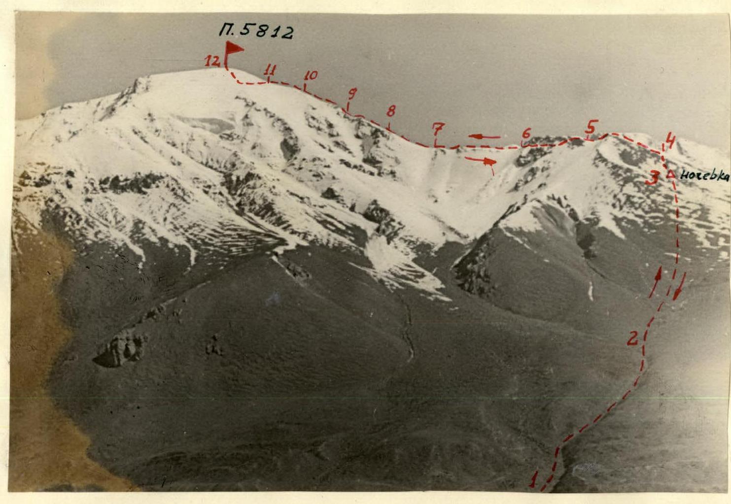
The route taken to ascend Peak "5812" via the south ridge.
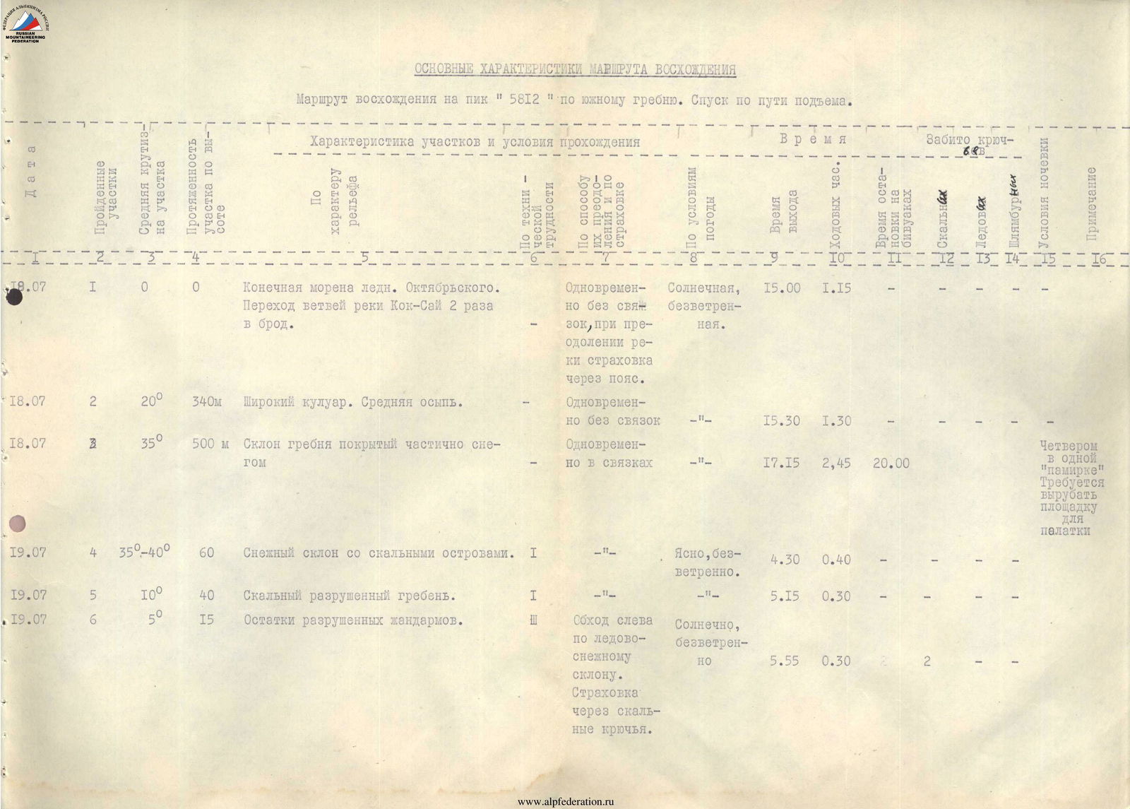
Main characteristics of the ascent route
The route to ascend Peak "5812" via the south ridge. Descent is via the ascent route.
| Date | Sections | Average steepness of the section | Height gain of the section | Characteristics of sections and passage conditions | Category of section | By method of overcoming and insurance | Temperature, wind | Departure time | Time en route | Arrival time | Pitons driven (on ascent) | Total pitons driven | Pitons lost | Notes |
|---|---|---|---|---|---|---|---|---|---|---|---|---|---|---|
| 18.07 | 1 | 0° | 0 m | Terminal moraine of the Oktyabrsky Glacier. Crossing branches of the Kok-Sai River twice. | - | Simultaneously, without rope teams, insurance via belt when crossing the river. | Sunny, windless | 15:00 | 1:15 | - | - | - | - | - |
| 18.07 | 2 | 20° | 340 m | Wide couloir. Medium scree. | - | Simultaneously, without rope teams | -". | 15:30 | 1:30 | - | - | - | - | - |
| 18.07 | 3 | 35° | 500 m | Slope of the ridge, partially covered with snow. | - | Simultaneously, in rope teams | -". | 17:15 | 2:45 | 20:00 | Four in one "pamirka". Required to carve out a campsite. | - | - | - |
| 19.07 | 4 | 35°–40° | 60 m | Snowy slope with rocky outcrops. | 1 | -". | Clear, windless | 4:30 | 0:40 | - | - | - | - | - |
| 19.07 | 5 | 10° | 40 m | Rocky, destroyed ridge. | 1 | -". | -". | 5:15 | 0:30 | - | - | - | - | - |
| 19.07 | 6 | 5° | 15 m | Remains of destroyed gendarmes. | - | Bypass on the left via the ice-snow slope. Insurance through rock pitons. | Sunny, windless | 5:55 | 0:30 | - | 2 | 2 | - | - |
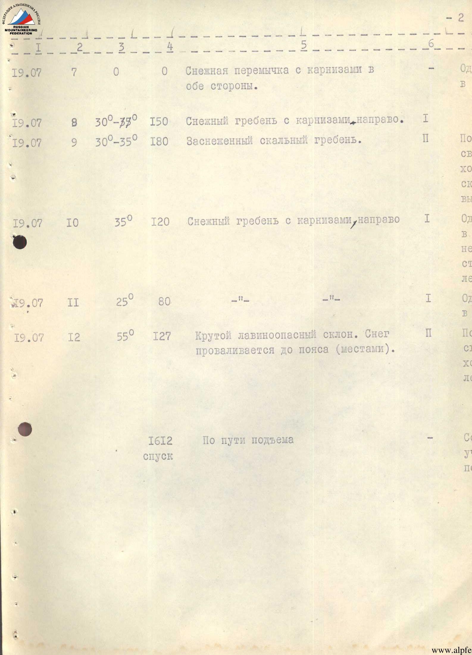
| 19.07 | 7 | 0° | 0 m | Snowy saddle with cornices on both sides. | - | Simultaneously, in rope teams | Sunny, windless | 6:30 | 0:35 | - | - | - | - | - |
| 19.07 | 8 | 30°–39° | 150 m | Snowy ridge with cornices to the right. | 1 | -". | -". | 7:10 | 1:00 | - | - | - | - | - |
| 19.07 | 9 | 30°–35° | 180 m | Snow-covered rocky ridge. | 2 | Alternating, in rope teams. Insurance through rocky outcrops. | -". | 8:15 | 1:15 | - | - | - | - | - |
| 19.07 | 10 | 35° | 120 m | Snowy ridge with cornices to the right | 1 | Simultaneously in rope teams, in some places insurance through an ice axe. | -". | 9:35 | 1:00 | - | - | - | - | - |
| 19.07 | 11 | 25° | 80 m | - | 1 | Simultaneously in rope teams | -". | 10:40 | 0:45 | - | - | - | - | - |
| 19.07 | 12 | 55° | 127 m | Steep, avalanche-prone slope. Snow sinks up to the waist (in places). | 2 | Alternating in rope teams. Insurance through an ice axe. | -". | 11:30 | 1:45 | - | - | - | - | Transition to the slope, as huge cornices hang on the narrow ridge to the right. |
| 1612 m | Via the ascent route | - | According to the ascent sections | -". | 13:30 | 4:30 | 18:45 | a | - | - | - |