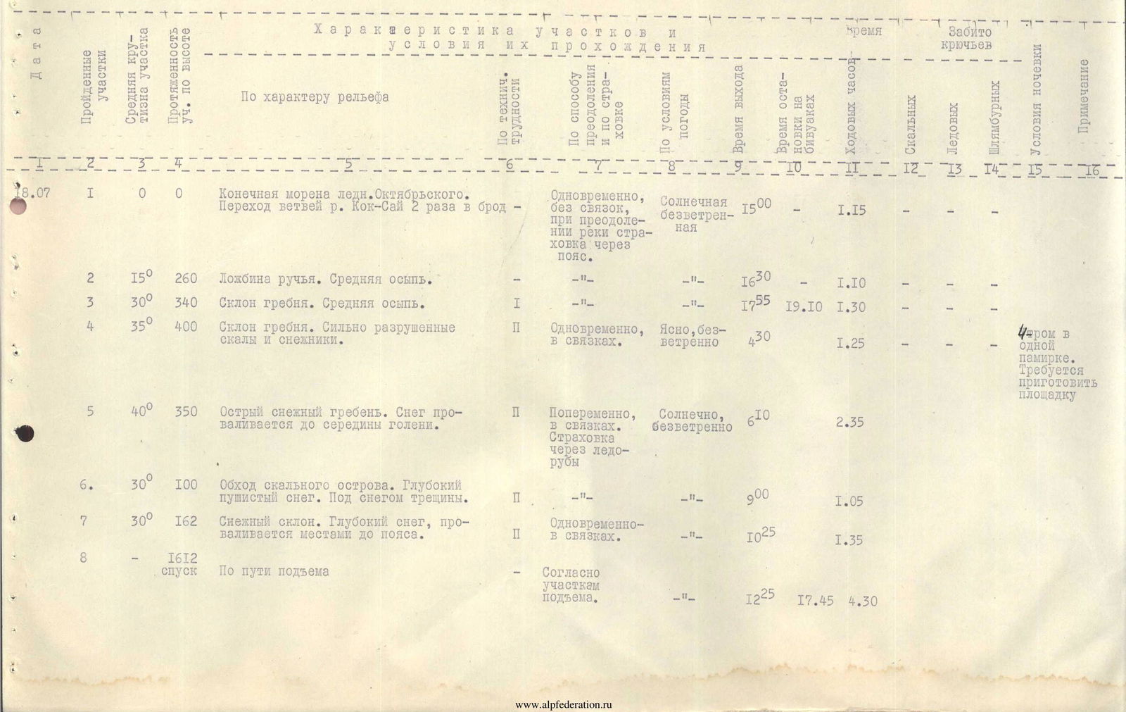
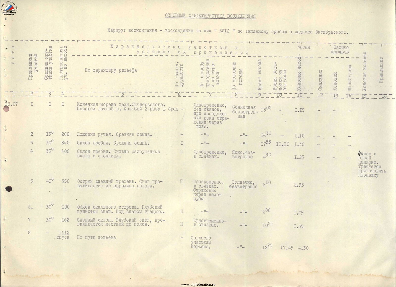
Route Description
Ascent to peak "5812" via the western ridge
Cat. difficulty 2B
Day 1
Departure at 15:00 from the base camp located at an altitude of 4200 m below the tongue of the Oktyabrsky glacier on the right orographic side of the valley. On the way to the foot of the peak, two branches of the Kok-Sai River are forded.
The duration of the path to the foot is about 1 hour.
The path to the summit begins along the gully of a stream flowing from a snowfield located in the cirque between the S and W ridges. The slope is 10°–15°. Further, the path goes along a slope of 30°–35° towards the S counterfort of the W ridge. The slope is covered with medium-sized scree.
The overnight camping spot is chosen at an altitude of about 4800 m on the S slope of the W ridge, where a campsite can be set up with a small amount of labor and there are snowfields to fetch water.
The duration of the path from the base camp to the overnight camping spot is 3.5–4 hours.
Day 2
Departure in the morning at 4:30 along a slope of 30°–35°, which is a heavily broken rock and snowfield terrain. Insurance is simultaneous. The ridge is reached at an altitude of about 5200 m. The ridge is sharp, with cornices on both sides in some places. The slope reaches 40°. Movement along the ridge is directed towards the summit dome. Insurance is alternating via ice axes.
At an altitude of 5600 m, the ridge turns into the W slope of the summit dome under a rocky outcrop located on the W slope of the summit dome. There are crevasses under the rocky outcrop. Traverse to the right under the rocky outcrop. The snow here is powdery and sinks up to the waist in places. Insurance is alternating via ice axes. After traversing to the right, the path leads onto the snowy W slope of the summit dome with a slope of 30° and then to the summit. Insurance is simultaneous. The duration of the path from the overnight camping spot is about 8 hours.
The summit is a snowy dome. The descent along the ascent path with simultaneous and alternating insurance to the overnight camping spot takes 3–4 hours and is complicated by the softened snow.
The descent from the overnight camping spot to the base camp takes 1.5–2 hours.
Conclusion
The conquered peak turned out to be of medium difficulty. The route was snowy.
The more difficult sections were the ridge and the exit onto the slope of the summit dome due to deep snow and crevasses. The harsh climate and high altitude also require attention.
Taking into account all the factors of this route, we propose to evaluate the ascent to peak "5812" via the western ridge as category 2B.
Group composition:
- TOHVER Y.Y. (leader);
- REKHTSALU S.A.;
- PALO I.A.;
- UUSNA A.A.
Main characteristics of the ascent
The ascent route is an ascent to peak "5812" via the western ridge from the Oktyabrsky glacier.