Peak XIX Partezda (5920 m), approximately category 5A, northwestern spur of the western ridge
For the Leningrad city championship in the ice and snow class
Team coach Master of Sports Stepanov I.V.
Leningrad 1982
- Traverse by the Leningrad State University team:
Peak XIX Partezda, Peak Spartak, Peak Lenin, Peak Razdel'naya
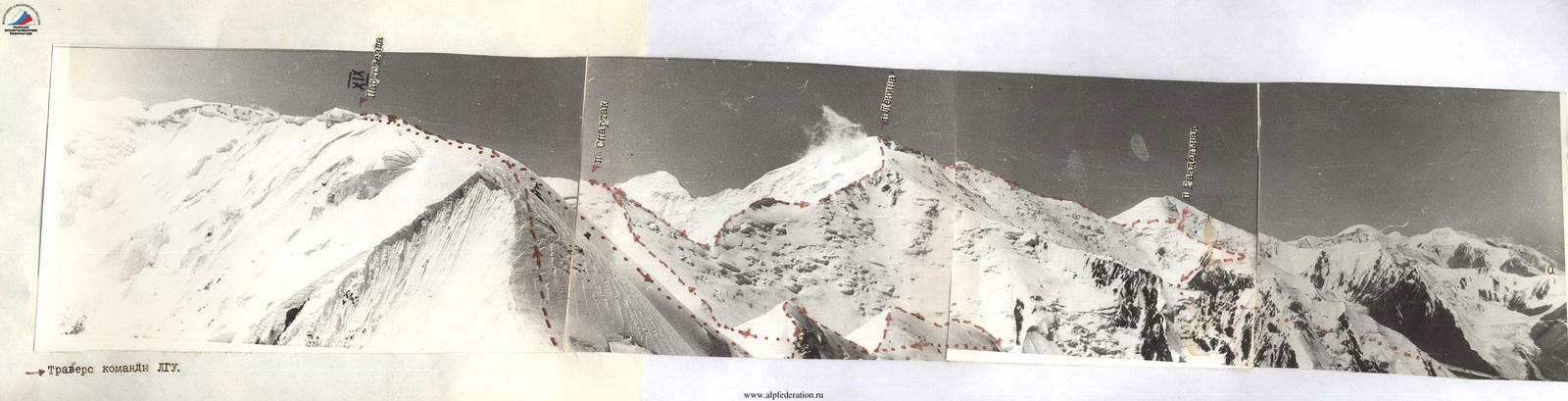
Route diagram according to ΦΙΛΑ
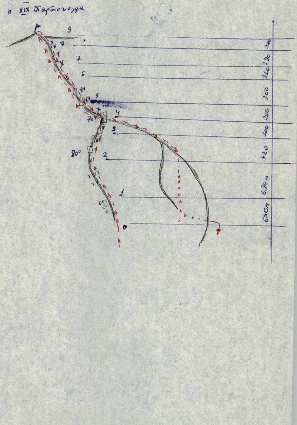
Brief explanation of the table
Preparation for the ascent
Preparation for this ascent was conducted throughout the entire preparatory period. The general physical training program included:
- Long-distance running (including marathons)
- Cross-country skiing
- Rock climbing training, etc.
Specialized training included trips to the rocks of the Karelian ASSR, including winter 1981–1982, and ice training in Sablino. During these trips, the existing specialized equipment was tested and fine-tuned.
Before the ascent, the participants spent 20 days climbing in the Pamir-Alay mountains, and immediately before the ascent, they climbed Peak Lenin (7134 m) via Peak Razdel'naya. Thus, the group achieved good acclimatization.
Tactical plan for the ascent
Day 1. August 16, 1982. Departure from the base camp at Lukovaya Polyana. Approach to the route. Overnight stay before the route.
Day 2. August 17, 1982. Start of the route. Passage of the spur. Overnight stay on the ridge of Peak XIX Partezda.
Day 3. August 18, 1982. Ascent to the summit. Descent via the ascent route. Return to the base camp at Lukovaya Polyana.
Alternate plan:
- Descent to Lenin Glacier East
- Return to the base camp via the Pereval Puteshestvennikov pass
Ascent chronicle
August 16, 1982. Departed from the base camp at Lukovaya Polyana at 17:00. Circumnavigated the ridge and descended to the river flowing from Lenin Glacier. Crossed the glacier towards the ridge of Peak XIX Partezda. Bypassed the ridge from the left. Crossed the moraine of the glacier flowing from Peak XIX Partezda. At 21:00, bad weather set in. Set up a tent on the moraine near the glacier.
August 17, 1982. Departed at 9:00. Began the route at 10:00. The start was a steep, rocky ridge with easy rocks. The slope was about 40°. After passing the rocky section, around 12:00, set up a control cairn near the rocky outcrops.
Further on, the snow and ice ridge had a slope of 20 to 60°. (200 m. Firn. Movement on front crampons. Rope team moved simultaneously. Protection via ice axe and ice screws. At 15:00, approached a flattening before the final ascent to the ridge. Crevasses. The ascent to the ridge had an average slope of about 45°. Several ice walls with slopes up to 80° and lengths of 2–10 m were ascended directly. Protection via ice screws. Avalanche danger. Movement was protected by ice walls under a large overhanging cornice. At 18:00, reached under the cornice, then moved rightwards to a vertical ice wall 2 m high. Protection via ice screws. Exit onto the western ridge and further left-upwards to a rocky outcrop. Set up camp for the night at 21:00.
August 18, 1982. Began movement along the snow and ice ridge at 9:00. Slope was 50°; ice walls were ascended on front crampons. The first ascent with rocky outcrops was traversed on the left, up to a flattening. Platforms for overnight stays. The pre-summit ascent was steep, with firn and ice walls up to 10 m high, and a slope of 60°. Protection via ice screws and ice axe. To the left was a cornice. The ascent led to the ...
Piton table
| Date | Designation | Average slope | Length | Character of relief | Difficulty | Condition | Weather conditions | Rock | Ice | Bolts |
|---|---|---|---|---|---|---|---|---|---|---|
| August 17, 1982 | R0–R1 | 40° | 630 | Rocky ridge | 3 | destroyed | clear | 0 | 0 | 0 |
| R1–R2 | 35° | 690 | snow and ice ridge | 4 | firn | clear | 0 | 3 | 0 | |
| R2–R3 | 45° | 420 | --//-- | 4 | firn, avalanches | clear | 0 | 6 | 0 | |
| R3–R4 | 70° | 100 | snow and ice wall | 5 | cornice | clear | 0 | 5 | 0 | |
| R4–R5 | 30° | 200 | snow and ice ridge | 2 | firn | clear | 0 | 0 | 0 | |
| Total for the day: 13 hours of walking time. Overnight stay in a lying position. | ||||||||||
| August 18, 1982 | R5–R6 | 50° | 300 | steep snow and ice ridge | 4 | firn, ice | clear | 0 | 3 | 0 |
| R6–R7 | 40° | 310 | snow and ice ridge | 4 | firn | clear | 0 | 0 | 0 | |
| R7–R8 | 50° | 390 | snow and ice ridge | 4 | firn | clear | 0 | 2 | 0 | |
| R8–R9 | 20° | 200 | snow and ice ridge | 3 | firn | clear | 0 | 0 | 0 |
Total for the day: 3 hours of walking time to the summit and 8 hours of walking time to the base camp.
Protocol
of the разбор of the ascent by the duo consisting of Krasnoukhov Yu.V. and Terekhov A.N. to Peak XIX Partezda (5920) on August 16–18, 1982.
Present:
- First releasing coach Master of Sports Stepanov I.V.,
- Second releasing coach Master of Sports Borzov Yu.V.,
- coaches,
- ascent participants,
- trainees.
Krasnoukhov Yu.V. The duo started the route on August 16, 1982, at 17:00. Via a familiar path, they crossed Lenin Glacier in its lower part, bypassed from the left the ridge of Peak XIX Partezda, and began moving along the moraines towards the spur. At 21:00, bad weather caught up with them, and they had to stop and set up a tent before reaching the start of the route. On August 17, 1982, at 9:00, they continued the ascent, reached the spur, and by 12:00 passed its rocky part. On one of the last rocky outcrops, they set up a control cairn. They put on crampons. Further on, they moved in a rope team along the ridge, passing steep ascents directly. In the upper part, the spur was avalanche-prone, so they decided to move protected by ice walls and ascend the walls directly. The most technically challenging part was passing the last 100 m before the cornice and exiting onto the cornice. By 20:30, they finished passing the difficult section and exited onto the 3rd ridge onto the route category 4A. At 21:00, they stopped for the night near the first rocky outcrop. The next day at 9:00, they continued the route. A series of steep ascents was passed directly on front crampons. The weather was good. At 12:00, they reached the summit. They did not find a note, as the summit was snowy. They left their note on an ice wall on the northern part of the summit and began the descent. At 14:00, they reached the overnight stay site and dismantled the camp. From above, they saw a convenient descent path to the southwest, into the cirque of Lenin Glacier East. During the descent, they explored the start of the traverse: Peak XIX Partezda (southern summit) — Peak Lenin.
At 20:00, they descended to the base camp at Lukovaya Polyana via Pereval Puteshestvennikov.
They were satisfied with their partner Terekhov A.N. He is becoming a good high-altitude climber. Modern equipment and good technical preparedness allowed them to pass difficult sections at a good pace and without accidents. At high altitude, they felt good. At all stages of the ascent, they worked cohesively and in harmony, thanks to their good teamwork.
Throughout the route, the weather was good, with weak winds. However, the character of the snow and ice relief indicates that winds can be strong here.
The route is technically more complex than the route to Peak Lenin via Peak Razdel'naya category 5A and other similar routes. Considering that the height of Peak XIX Partezda is 1 km less than Peak Lenin, they believe the route should be classified as category 5A.
Terekhov A.N. The ascent was enjoyable. Working in a rope team with an experienced partner like Yu.V. Krasnoukhov is very pleasant. Throughout the route, they worked confidently, with a large "safety margin," precisely following the tactical plan for the ascent. The route is technically more complex than the route to Peak Lenin via Peak Razdel'naya category 5A. They believe the route they passed corresponds to category 5A. The equipment "worked" excellently.
Stepanov I.V. The duo successfully completed the task. The route was passed without accidents, with a "safety margin," and at a good pace. The route corresponds to category 5A. Propose to credit the ascent to the participants.
The protocol was led by A.N. Terekhov
 Summit dome of Peak XIX Partezda
 Start of the route to Peak XIX Partezda (descent path)