ASCENSION PASSPORT
- Type of ascension — High-altitude and technical.
- Area of ascension — Zaalayskiy Ridge, Pamir.
- Peaks, their height, ascension route — Traverse of p. XIX Partsezd (5920 m) – p. Spartak (6183 m) – p. Razdelnaya (6148 m) – p. Lenin (7134 m), with ascent to the Southern peak of p. XIX Partsezd via the western ridge.
- Proposed difficulty category — 5B.
- Route characteristics: height difference — 3000 m, length of sections: 1st category of difficulty — none, 2nd category of difficulty — 325 m, 3rd category of difficulty — 4230 m, 4th category of difficulty — 5930 m, 5th category of difficulty — 450 m. Average steepness — 30°.
- Number of pitons used: for creating artificial support points — none, for belaying — 18. Among them, rock pitons — 8, ice pitons — 10, screw pitons — none.
- Number of walking hours — 54 hours, 6 days.
- Number of nights and their characteristics — 5 nights, lying down.
- Surname, name, patronymic of the team leader, participants, and their qualification: Krasnoukhov Yury Vasilyevich — Master of Sports of the USSR, team leader; Koval Sergey Lvovich — Candidate for Master of Sports; Terekhov Alexander Nikolayevich — 1st sports category; Yamaev Vitaly Alekseyevich — 1st sports category.
- Team coach — Stepanov Igor Vasilyevich, Master of Sports.
- Date of departure for the route — August 20, return — August 25, 1982.
Brief geographical and mountaineering characteristics of the area
The Zaalayskiy Ridge, in the central part of which are the peaks XIX Partsezd, Spartak, and Lenin, forms the northern border of the Pamir. This ridge stretches in the latitudinal direction for 150 km and borders on the east with the western spurs of Kokshata (Tien Shan), and on the west — with the confluence of the Muk-su and Kyzyl-su rivers.
The heavily glaciated northern slope of the ridge faces the Alay Valley. Over a considerable extent, the average heights exceed 6000 m.
At the extreme east of the ridge is the trapezoid-shaped peak — Zarya Vostoka (6346 m), to the right of it — the Kurumtsy massif, peak Pограничник (5434 m). To the west of peak Pограничник lies a wide valley, through which the Pamir Highway Osh — Khorog passes. To the west of the Pamir Highway are the Gоры Korzhenevskogo. The snowy ridge of Gоры Korzhenevskogo (highest point — 6075 m) turns into peak Kyzylagyn (6679 m). Further on is the ridge Barrikad, and then peak Lenin. Behind p. Lenin rise the peaks Dzerzhinskogo (6713 m), Krasina (5996 m), and Tsurupy (5845 m). The last pointed peak, rising like a regular trapezoid, is named peak Sverdlova (5451 m). These names were given in 1928 by the leaders of the Soviet-German expedition N.P. Gorbunov, N.V. Krylenko, and O.Yu. Schmidt.
The slopes of the Zaalayskiy Ridge are steep, cut by a system of short, wide valleys, closed by sheer walls. The valleys are drained by a few glaciers. Modern glaciation of the Zaalayskiy Ridge is very significant and ranks immediately after glaciers like Fedchenko (Pamir) and Inyylchek (Tien Shan). Over 20 years, from 1945 to 1965, the glaciers retreated significantly. For example, the Lenin Glacier, with a length of 9 km, retreated by 1300 m, resulting in the separation of its eastern and western branches, between which is the eastern ridge of p. Lenin with p. K. p. Kompleksny (5547 m). From the southern slopes of the peak flow the glaciers Bolshoy (to the east) and Maly (to the west) Saukdara.
Peak Lenin (7134.3 m) is located in the middle part of the Zaalayskiy Ridge and is its main peak. To the west, peak Lenin is connected to peaks Razdelnaya and Dzerzhinskogo; to the east — through the Krylenko Pass (5820 m) and peak Spartak (6183 m) — with the ridge p. Edinstva (6673 m). To the south, in the spur of the p. Lenin massif, is p. Zhukova (6852 m).
In the area of the Lenin Glacier, outcrops of bottom moraines are visible, resembling Gothic castles with sharp spires. The height of peak Lenin above the Lenin Glacier averages 3000 m. The steepness of the slopes reaches 45–55 degrees. The slopes are cut by deep crevasses; frequent ice falls occur on them, and a large number of snow avalanches descend.
Atmospheric pressure at an altitude of 7134 m is 290 mm Hg against 760 mm at sea level. The climate of the peak Lenin area is characterized by sharp contrasts. In the lower part, it is moderate, and in the high-altitude zone, it takes on polar features. Temperature fluctuations, both annual and diurnal, are very significant. In the hottest time of the year, they can reach 30–40 degrees: from +5 during the day to −30 at night. The prevailing winds have a southwest and west direction and speeds of up to 15 m/s. On the ridge, a significant densification of firn is observed, formed as a result of hurricane winds tearing off tents. Based on average long-term data, V.I. Ratsek recommends the first half of August for ascents to peak Lenin.
The massif of p. Lenin, like all the northern slopes of the Zaalayskiy Ridge, is composed of limestones, schists, and sandstones.
Peak Spartak is a key peak; at this point, the northern spur (Lедяной мыс) and the southern spur (Zulmart) branch off from the Zaalayskiy Ridge.
Peak Spartak is adjacent:
- to the west, through the Krylenko Pass, to p. Lenin;
- to the north, through the Korzhenevskogo Pass, to p. XIX Partsezd;
- to the south, to peak Edinstva.
The slopes of p. Spartak to the east feed the Korzhenevskogo Glacier, and to the west — the eastern Lenin Glacier. Peak XIX Partsezd (5920 m) is located in the spur Lедяной мыс. From the Lukovaya Polyana — the usual location of expedition base camps — the northern snow-ice slopes of this massif are clearly visible. Two western and one eastern ridges, extending from the Lедяной мыс ridge, form a large massif with three separate snowy peaks, little different from each other in height but located at a considerable distance from each other. Peak XIX Partsezd to the north adjoins peak Mir, to the east — peak Lедяной мыс.
The study of the Zaalayskiy Ridge began in 1774–1787 — during the travels of the Russian prisoner F. Efremov, who passed through the Fergana Valley, over Osh, crossed Chigirchik and Terekdavan into Kashgaria. He was the first European to cross the Alay.
Scientific research of the Alay began in 1871, when A.P. Fedchenko discovered the Zaalayskiy Ridge and its main peak. The first to visit the immediate vicinity of peak Lenin was the well-known Pamir researcher N.L. Korzhenevsky.
In 1928, a Soviet-German expedition to the Pamir was organized under the leadership of N.V. Krylenko and N.P. Gorbunov to study the Zaalayskiy Ridge. After its completion, on September 25, 1928, the German participants E. Allwein, K. Wien, and E. Schneider conquered p. Lenin from the south via the Krylenko Pass. The day before, they mistakenly ascended peak 6183 (Spartak), confusing the direction to peak Lenin.
Currently, more than 16 different routes have been taken to peak Lenin, and annually over 100 people conquer this peak.
Peak 6183 (Spartak) was conquered from the south by a group led by K. Kuzmin on August 21, 1955, during an ascent to p. Lenin from the Oktyabrsky Glacier via p. Edinstva.
Peak XIX Partsezd was first conquered via the western ridge by a team of Spartakovets alpine climbers led by Honored Master of Sports V. Abalakov.
Among the known traverses involving p. Lenin, we can note:
- the traverse by a group led by V. Abalakov: p. Dzerzhinskogo — p. XIX Partsezd;
- the traverse carried out under the leadership of K. Kuzmin: p. Oktyabrsky — p. Lenin.
Reconnaissance
The route was observed from August 5 to 20, 1982, by team members and members of the LGU sports club gathering from the Lenin Glacier to optimally choose the ascent path and analyze avalanche occurrences on the proposed route.
Before starting the route, the traverse participants Krasnoukhov Yu., Terekhov A., and Koval S. made an ascent to p. Lenin via v. Razdelnaya to study the descent path from p. Lenin and for good high-altitude acclimatization. This route (p. Lenin via Razdelnaya) was taken by team member V. Yamaev in 1979. Good familiarity with the descent path from p. Lenin for all team members ensured increased safety during the traverse in bad weather.
From August 16 to 18, Yu. Krasnoukhov and A. Terekhov made an ascent to the central peak of p. XIX Partsezd via a new route and, descending to the eastern Lenin Glacier, finally chose the ascent path and approach routes.
Before starting the traverse, the team had a clear understanding of:
- the condition and structure of rock and snow-ice sections;
- the avalanche hazard of the slopes;
- possible emergency descent routes.
The locations of overnight stays were planned, and a tactical ascent plan was developed day by day.
Description of the approach to the start of the route:
The route involves traversing the peaks XIX Partsezd, Spartak, and Lenin, with an ascent to the southern peak of p. XIX Partsezd via a new path along the western ridge. To date, a similar traverse has been made:
- by a group led by V. Abalakov in the opposite direction (p. Dzerzhinskogo – p. XIX Partsezd);
- by a group led by A. Pyan'kov in 1967 (from the Sauk-Dara Glacier through peaks 6257, Marshal Zhukov, p. Lenin, p. XIX Partsezd).
In the direct direction, the route section from the Krylenko Pass to the summit of p. Lenin has been traversed.
The approach to the route from the base camp on Lukovaya Polyana in the Aчик-Таш tract follows a trail along a side gorge, bypassing the "Pалatка" rock to the right. Before reaching a small glacier flowing from the northern slope of the gorge, the trail turns left onto a saddle in the ridge called the "Pутешественников" Pass. From the pass, there is a steep descent to the Lenin Glacier (western). After ascending the glacier along its middle part, it is necessary to cross it in the direction of the Krylenko Pass and move to the eastern Lenin Glacier. Ascending the glacier, approach the start of the route: a huge triangle of dissected rocks on the western ridge of the southern peak of XIX Partsezd. The ascent path begins along the right part of the triangle.
Tactical Ascent Plan
Before starting the route, all team members underwent good acclimatization, having overnight stays at heights above 6000 m; all team members had previously been on p. Lenin, with three having done so in the same season. Techniques for moving on ice, snow, and rocks were practiced by team members both in winter on the rocks of the Karelian Isthmus and in Sablinko, and during the current climbing season on various peaks in the Pamir-Alay mountains. Considering all available information about the route and the condition of the team members, a tactical ascent plan was developed:
-
1st day, September 20, 1982. Departure from the base camp on Lukovaya Polyana at 6:00, approach to the route, start of ascent on the western ridge of p. XIX Partsezd. Overnight stay on the ridge, at the top of the rock triangle, height about 5000 m.
-
2nd day, September 21, 1982. Continuation of ridge ascent, reaching the summit of p. XIX Partsezd (5920 m); movement towards p. Spartak; overnight stay on the Korzhenevskogo Pass.
-
3rd day, September 22, 1982.
-
Movement along the ridge to p. Spartak;
-
reaching its summit;
-
movement towards the Krylenko Pass;
-
overnight stay in the area of the Krylenko Pass (5820 m).
-
4th day, September 23, 1982.
-
Movement towards p. Lenin;
-
overnight stay before the summit at a height of about 6800 m.
-
5th day, September 24, 1982.
-
Continuation of movement to the summit of p. Lenin;
-
reaching the summit (7134 m);
-
descent towards p. Razdelnaya;
-
overnight stay on the saddle between p. Lenin and p. Razdelnaya;
-
alternative option: overnight stay in the area of the "запятая" or on the summit.
-
6th day, September 25, 1982.
-
Descent to the base camp via p. Razdelnaya;
-
alternative option: descent from the saddle between p. Lenin and p. Razdelnaya to the 5300 m plateau and then to the base camp on Lukovaya Polyana.
-
7th day, September 26, 1982.
-
Reserve day.
The tactical ascent plan was adhered to despite bad weather throughout the ascent days.
Ascent Chronicle
September 20, 1982. The group departed from the base camp at 10:00. The departure was delayed because it snowed all night and in the morning, with continuous fog. We followed the trail to the "Pутешественников" Pass and descended to the western Lenin Glacier. Then we crossed several moraines and by 13:30 reached the eastern Lenin Glacier. We moved along the glacier in the direction of the Krylenko Pass, then under the western ridge of p. XIX Partsezd, which was a rock triangle. At 15:00, we approached the start of the route. The weather was variable. Only by 15:00 did the snow stop, and some visibility appeared.
Bypassing the triangle to the right, along the talus and heavily destroyed rocks, we reached a rock counterfort extending from the ridge. The first to work was Yu. Krasnoukhov. The counterfort was bypassed to the right. Then we followed a steep, largely destroyed couloir. The steepness was 45°. The couloir was icy at the top. We reached the ridge at 20:00. The weather worsened again; snow started falling at 17:30, with visibility reduced to 30 m. On the ridge, at one of the rock islands, we set up camp for the night. The height was about 5000 m.
September 21, 1982. It snowed all night, and we had to dig out the tent several times. Snow continued until 10:00, with zero visibility. At 10:00, the fog cleared, and we proceeded with the route. The first to work was A. Terekhov. From this camp and until the descent to 4200 m, we moved only in crampons. From the camp, we ascended the ridge (deep snow, ice) along the rocks for 200 m, with a steepness of 60°. Then we continued up the snow-ice ridge (1400 m) under the pre-summit ascent. There were individual steep ice walls, many crevasses, and belaying via an ice axe. Steep walls were ascended frontally on the front points of crampons. In some places, the layer of fresh snow was very deep, and we had to dig a trench. The steepness varied from 20 to 45 degrees. The pre-summit ascent began with deep, steep snow (about 100 m, 50°) and turned into an ice wall 60 m long with a steepness of 80–85°. Movement was on the front points of crampons with belaying via ice screws; fixed ropes were established. At the top of the wall, we reached a large ice crevasse crossing the pre-summit dome. Then we moved 40 m along the left edge of the crevasse to the pre-summit ridge, which led left. Along this ridge, adjacent to a large corniche, we reached the sharp, purely snowy summit (Southern peak of p. XIX Partsezd).
We reached the summit at 16:00. We began our descent to the Korzhenevskogo Pass along an extremely narrow snowy ridge with a corniche on the left. At 17:00, the weather worsened; light snow fell, and fog descended. At 19:00, we set up camp for the night on a wide saddle in conditions of zero visibility.
September 22, 1982. We departed on the route at 9:40. The first to work was S. Koval.
From the saddle, we ascended under a dome-shaped snow-ice ascent with a steepness of up to 50° (100 m), overcome on the front points of crampons. Then:
- along a very sharp snow, partly ice ridge with a corniche on the left (500 m);
- descended under the start of a wide ridge leading to the summit of Spartak.
From 12:00, an icy wind blew, almost knocking us off our feet. Visibility was nil, with occasional glimpses through the fog. On the ridge, there was deep, loose snow, and we had to dig a trench to our height. The leader constantly changed between the связка A. Terekhov — S. Koval. The leading climber changed frequently.
Movement along the ridge:
- initially, directly;
- then along the right part towards rock islands (40°, 600 m);
- further, adhering to rock islands, upwards to an ice wall.
In the middle part of the ridge, the связка Yu. Krasnoukhov — V. Yamaev took the lead. Steepness was 20–40°; in some places, the ridge, especially on the left, was avalanche-prone.
The ice wall (40 m, 70°):
- was ascended frontally on the front points of crampons;
- belaying was done via ice screws, and fixed ropes were established;
- the first to ascend was A. Terekhov.
The wall turned into a snowy slope, and further — into a gentle talus, leading to the summit of p. Spartak, which was a small elevation on the osypnoy ridge leading to p. Oktyabrsky.
We reached the summit at 16:30. Visibility was zero; there was a strong wind and snowfall. We found a записка left by a group of tourists from Vilnius under the leadership of V. Vitkauskas.
We began our descent to the west along the ridge leading to the Krylenko Pass. Yu. Krasnoukhov led, practically feeling his way in complete darkness.
The ridge was initially osypnoy, then turned into ice. Steepness increased from 30° to 45–50°. At 18:00, due to lack of visibility and increasing ice steepness, we stopped for the night. Around 4:00, we had to dig out a platform on a steep ice slope.
September 23, 1982. We exited the camp at 9:15. The fog was patchy, with temperatures below -20°, and a strong wind with snow; it was impossible to walk without a mask.
We continued our descent; it turned out that the distance to the Krylenko Pass was only 100 m. From the pass, there was a snow-ice ascent with a steepness of 40° and a length of about 600 m. V. Yamaev led. We reached the flattening of the ridge at 11:45.
The wind intensified; gaps in the fog became rarer and eventually disappeared. We moved along the ridge towards rock islands (steepness 15–20°).
Due to complete lack of visibility and a strong wind with snow, we set up camp at 14:00, digging a pit for the tent in deep snow.
By 16:00, gaps appeared in the fog; the wind eased slightly, and we managed to discern the further ascent path. A consultation via radio with our coach, I.V. Stepanov, was very helpful, advising us on how to continue movement in low visibility.
Continuing the movement, we traversed a snow-ice slope with a steepness of 40° to a wide crevasse on the ridge (400 m) and further to a flattening with rock islands on the right at the edge of the ridge.
Here, we stopped for the night as we could not see where to go further. At 18:45, we set up camp. The location was good, but there was no protection from the wind, and descending the slope was not possible due to ice drops.
September 24, 1982. The wind strengthened to hurricane force at night. We removed the tent stakes to prevent it from being torn away with us. Throughout the night, we held the tent to prevent it from "flying away." By morning, our new high-altitude tent, with additional stitching on the seams, was torn in several places.
In the morning, the wind did not subside; visibility was 10 m. After receiving another consultation from our coach via radio, we started on the route at 11:00. Yu. Krasnoukhov led.
Movement:
- along rock islands;
- then along a gentle ridge to the next flattening.
The wind did not subside; fog and snow continued. At 14:00, due to lack of visibility, we stopped on a flat part of the ridge, descending down the slope to partially hide from the wind. We dug a pit and set up camp.
At 15:30, a brief clearing in the fog allowed us to discern the further path. In continuous fog, we moved forward until 18:00. We stopped for the night in the area of the "запятая" (about 7000 m).
We set up camp under a rock island, descending far down a very steep snowy slope (45°) and digging a platform directly into the slope. We secured the tent using rock pitons. It was impossible to camp on the ridge due to the hurricane wind.
Until 24:00, we repaired the tent, which was challenging in the extreme cold.
September 25, 1982. We started on the route at 10:00. The wind was knocking us off our feet; it was very cold, and our legs were freezing even in valenki. There was a blizzard.
It took a long time to pack up the tent, which the wind did not allow us to fold even under the slope at the campsite.
The first to move was the связка Yu. Krasnoukhov — V. Yamaev. The slope steepness reached 70°; in some places, we had to move on the front points of crampons.
At 12:00, the group reached the summit of p. Lenin. We found a записка left by a group of the RS DSO "Spartak", SK "Instrumentalschchik" under the leadership of S. Streltsov on August 20, 1982.
We immediately began our descent towards p. Razdelnaya. Visibility was nil; there was a strong wind with snow, but we were familiar with the descent path and by 15:00 had descended to the 6400 m plateau, having only slightly deviated from the optimal path. Visibility improved to 30 m.
At 15:45, we were on the saddle between p. Lenin and p. Razdelnaya. Assessing the slope condition leading down from the saddle to the 5300 m plateau, we decided to descend here, although the tracks of previous groups were covered by the blizzard.
A. Terekhov led. At 18:30, we reached the 5300 m camp; by 20:00, we had descended to the 4300 m camp. Here, we were met by a group from our gathering, which had come out from the base camp to meet us. With their help, we arrived at the base camp on Lukovaya Polyana at 23:50.
Table of Main Route Characteristics
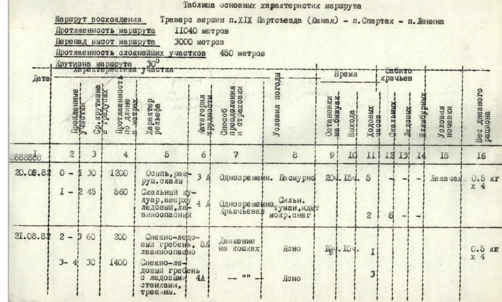
Traverse of peaks p. XIX Partsezd (Southern) – p. Spartak – p. Lenin Route length 11040 m Height difference 3000 m Length of most complex sections 450 m Steepness of the route 30°
| Date | Section | Angle of steepness in degrees | Length along the route, m | Character of relief | Category of difficulty | Method of movement and belaying | Weather conditions | Overnight stays | Time of departure | Walking hours | Rock pitons | Ice pitons | Screw pitons | Conditions of overnight stay | Weight of daily ration |
|---|---|---|---|---|---|---|---|---|---|---|---|---|---|---|---|
| August 20, 1982 | R0–R1 | 30 | 1200 | Talus, destroyed rocks | 3 | Simultaneous. | Overcast | 20:45 | — | 5 | — | — | — | Lying down | 0.5 kg × 4 |
| R1–R2 | 45 | 560 | Rock couloir, ice, avalanche-prone | 5 | Simultaneous | Fog, wet snow | — | — | — | 2 | 8 | — | — | — | |
| August 21, 1982 | R2–R3 | 60 | 200 | Snow-ice ridge, avalanche-prone | 5 | Movement in crampons | Clear | 10:00 | — | 1 | 1 | — | — | — | 0.5 kg × 4 |
| R3–R4 | 30 | 1400 | Snow-ice ridge with ice walls, crevasses. | 4 | — | Clear | — | — | — | — | — | — | — | — | |
| R4–R5 | 85 | 60 | Ice wall | 5 | Front points of crampons. Piton belaying | Clear | — | — | 1 | — | 6 | — | — | — | |
| R5–R6 | 10 | 200 | Snow dome, ridge, crevasses | 2 | Simultaneous. | Clear | — | 0:30 | 0:30 | — | — | — | — | — | |
| R6–R7 | 20 | 2050 | Snow ridge with corniches, partly ice, deep snow. | 3 | Movement in crampons | Fog, strong wind, snow | 19:00 | — | 3 ч 30 мин | — | — | — | Lying down | — | |
| August 22, 1982 | R7–R8 | 0 | 600 | Snow-ice ascent, then sharp ridge: left – corniche, right – avalanche-prone | 4 | Movement in crampons | Fog, wind 10 m/s, blizzard | 9:40 | — | 1 ч 30 мин | — | — | — | — | 0.5 kg × 4 |
| R8–R9 | 40 | 1400 | Snow-ice ridge with rock islands. Deep snow | 4 | In a trench | Fog, wind 20 m/s, blizzard | — | — | 4 | — | — | — | — | — | |
| R9–R10 | 70 | 40 | Ice wall | 5 | Front points of crampons. Piton belaying | — | — | — | 1 | — | 4 | — | — | — | |
| R10–R11 | 20 | 125 | Firn, talus | 2 | Movement in crampons | — | — | — | 6 ч 30 мин | — | — | — | — | — | |
| R11–R12 | 40 | 300 | Ice ridge, left and right – drops and crevasses | 4 | — | Fog, visibility less than 10 m, blizzard | 18:00 | — | 1 ч 30 мин | — | — | — | Lying down on a carved ice ledge | — | |
| August 23, 1982 | R12–R13 | 50 | 130 | Snow-ice ridge | 4 | Movement in crampons | Fog, wind 20 m/s, blizzard, frost below -30° | — | 9:15 | 0 ч 30 мин | — | — | — | — | 0.5 kg × 4 |
| R13–R14 | 40 | 230 | Ice-firn ridge | 4 | — | — | — | — | 3 ч 30 мин | — | — | — | — | — | |
| R14–R15 | 20 | 380 | — | 3 | — | — | — | — | 1 ч | — | — | — | — | — | |
| R15–R16 | 40 | 400 | — | 4 | — | — | — | — | — | — | — | — | — | — | |
| R16–R17 | 10 | 300 | Ice-snow ridge with crevasses | 3 | — | — | 18:45 | — | 1 | — | — | — | Lying down, hurricane at night | — | |
| August 24, 1982 | R17–R18 | 30 | 300 | Snow ridge, deep snow, firn. | 3 | — | Fog, frost about -30°, wind 25–30 m/s, blizzard | 11:00 | — | 2 ч 30 мин | — | — | — | Lying down on a ledge in a steep slope | 0.5 kg × 4 |
| R18–R19 | 45 | 210 | — | 4 | — | — | 18:00 | — | 3 | — | — | — | — | — | |
| August 25, 1982 | R19–R20 | 60 | 150 | Ice ridge | 5 | Movement on front points of crampons | Fog, hurricane wind, frost about -40° | 10:00 | — | 2 | — | — | — | — | 0.5 kg × 4 |
| R20–R21 | Descent | — | From p. Lenin via p. Razdelnaya | — | — | — | 24:00 | — | 12 | — | — | — | In the base camp | — |
Overall Assessment of Participants' Actions
According to the team captain and coach, all ascension participants were technically and physically well-prepared, with excellent acclimatization.
Despite exceptionally unfavorable weather conditions, the participants:
- worked cohesively, energetically, and initiatively;
- demonstrated high moral and volitional qualities;
- acted in a coordinated manner, with everyone taking turns leading.
The psychological climate was excellent.
Communication with the base camp was carried out uninterruptedly via the "Стриж" radio station. Communication was regular at 9:00, 15:00, and 19:00. On August 25, due to extremely unfavorable weather conditions, communication was conducted every hour.
Notable new equipment samples were used:
- "Макалу" type crampons, which demonstrated very high operational qualities when ascending ice walls on the front points;
- All-metal ice axes;
- S. Efimov's autoclave, which saved us a lot of time and gasoline for cooking.
All non-standard equipment samples were tested by team members during training sessions and ascents. The test results significantly exceeded the established standards specified in the Methodological Letter of the USSR Alpine Federation from 1970.

