-
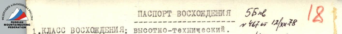
ASCENT CLASS: High-altitude-technical.
-
ASCENT AREA: Mazarsky Ridge, Pamir.
-
PEAK, ITS HEIGHT, ASCENT ROUTE: Peak 5772 m (central summit) via the southwestern edge (first ascent).
-
PROPOSED DIFFICULTY CATEGORY: 5B, first ascent.
-
ROUTE CHARACTERISTICS: height difference — 2572 m, length of sections with 5B difficulty category — 1135 m, average steepness:
- approach to the start of the southwestern edge — 35° (with a height difference of 270 m),
- along the southwestern edge — 50° (with a height difference of 1930 m),
- along the pre-summit ridge — 55° (with a height difference of 372 m),
- entire ascent route (from the glacier to the summit) — 55°.
-
TOTAL PITS:
| № | Name | On ascent insurance | Org. artificial support points | On descent | For bivouac organization | Total |
|---|---|---|---|---|---|---|
| 1 | Rock | 122 | 7 | 57 | 20 | 206 |
| 2 | Ice | 13 | - | 31 | 4 | 48 |
- TOTAL TRAVEL HOURS: ascent — 41, descent — 14, total — 55.
- NUMBER OF NIGHTS AND THEIR CHARACTERISTICS: 6 nights, 2 of which on descent:
- height 3825 m, on a rocky ridge, in a tent, good;
- height 4200 m, on a rocky ridge, in a tent, good;
- 4825 m, on a rocky counterfort, in a tent, sitting;
- height 5400 m, on a rocky-ice ridge, in a tent, good;
- height 5650 m, on an ice ridge, in a tent, good;
- height 5380 m, on a rocky counterfort, in a tent, mediocre.
- SURNAME, NAME, PATRONYMIC OF THE TEAM LEADER, PARTICIPANTS, AND THEIR QUALIFICATION:
- KREMENA VALERY PETROVICH, CMS — team leader, coach.
- KORENEV EDUARD ANATOLIEVICH, CMS — participant.
- EFIMOV VIKTOR BORISOVICH, 1st sports category — participant.
- GERASIMENKO ANATOLY ANDREEVICH, 1st sports category — participant.
- TEAM SENIOR COACH: PENCHUK VALENTIN LAVRENTIEVICH, Master of Sports of the USSR, senior instructor.
- DEPARTURE AND RETURN DATES: Departure — July 26, 1978, return — August 1, 1978.
Geographical Overview of the Ascent Area. Object of Ascent.
For participation in the championship of the Central Council of the Zenit Sports Society in 1978, our team chose a less visited region of the Pamir — the upper reaches of the Mazar Valley. This area attracted our attention with numerous high peaks representing significant sports-alpinism interest and good stable weather.
In the chosen area, it is possible to ascend peaks via new routes and make first ascents on still unconquered peaks. Until us, not many climbers had visited the peaks of this vast area.
Thus, from the alpinist chronicle, it is known that in 1957, a group led by D. Medzmariashvili traversed a section of the Darvaz Range from the Vanch River valley.
Directly in the Mazar Valley, a Leningrad "Trud" expedition took place in 1974, led by G. A. Chunovkin, whose team ascended the eastern peak of the Arnavad massif (6083 m) and took first place in the USSR Championship. The materials from this expedition, as well as consultations with its participants, helped us in choosing objects and ascent routes.
In 1977, climbers from a Khar kov gathering led by Yu. G. Grigorenko-Prigoda ascended the Surayshe Peak (5605 m) and Peak 5248 m, located on the Mazar Ridge, ascending them from the north from the Bokhud River valley.
In May 1978, three people from our society conducted a deep reconnaissance of the area. The reconnaissance materials allowed us to study approaches and clarify ascent objects.
The Mazar Valley is located between two ridges — the Darvaz Range (to the south) and the Mazar Ridge (to the north). In the eastern part, the Mazar Ridge merges with the Darvaz Range, closing the valley. At this point, between the Darvaz and Mazar ridges, there is one of the large glaciers in the area — the Mazar Glacier, which gives rise to the turbulent and full-flowing Obi-Mazar River, a left tributary of the Obikhingou River.
The Mazar Ridge in this area represents a continuous chain of peaks over 5000 m with a height difference of over 2000 m. The southern slopes of the Mazar Ridge are slightly indented and drop to the valley mainly with steep walls and edges. The northern slopes of the Darvaz Range, on the contrary, have significant glaciation, are replete with numerous spurs forming a confusing network of ridges and cirques. From the side of the Darvaz Range, a large left branch flows into the Mazar Glacier from Peak Arnavad. The upper reaches of the Mazar Glacier at the junction of the Mazar and Darvaz ridges form a vast firn plateau at a height of 4500 m, dropping to the north, to the main course of the glacier, with a steep and difficult-to-pass icefall.
To the south of the Mazar Valley is the Darvaz Glacier valley, which gives rise to the first full-flowing left tributary of the Obi-Mazar River. Our base camp was located within a half-hour walk from the confluence of the two valleys downstream along the Obi-Mazar River in a poplar grove. The location was successful: a clean stream and shade from trees created good conditions for rest, and dry firewood in sufficient quantity solved the problem not only of fuel for the kitchen but also for a bath. On the central moraine of the Mazar Glacier, at the point of its confluence with its left branch from the Arnavad massif, an advanced camp was set up with a supply of food and an emergency fund. Reconnaissance-acclimatization exits, selection of ascent objects, insurance, and observation of teams were carried out from the advanced camp.
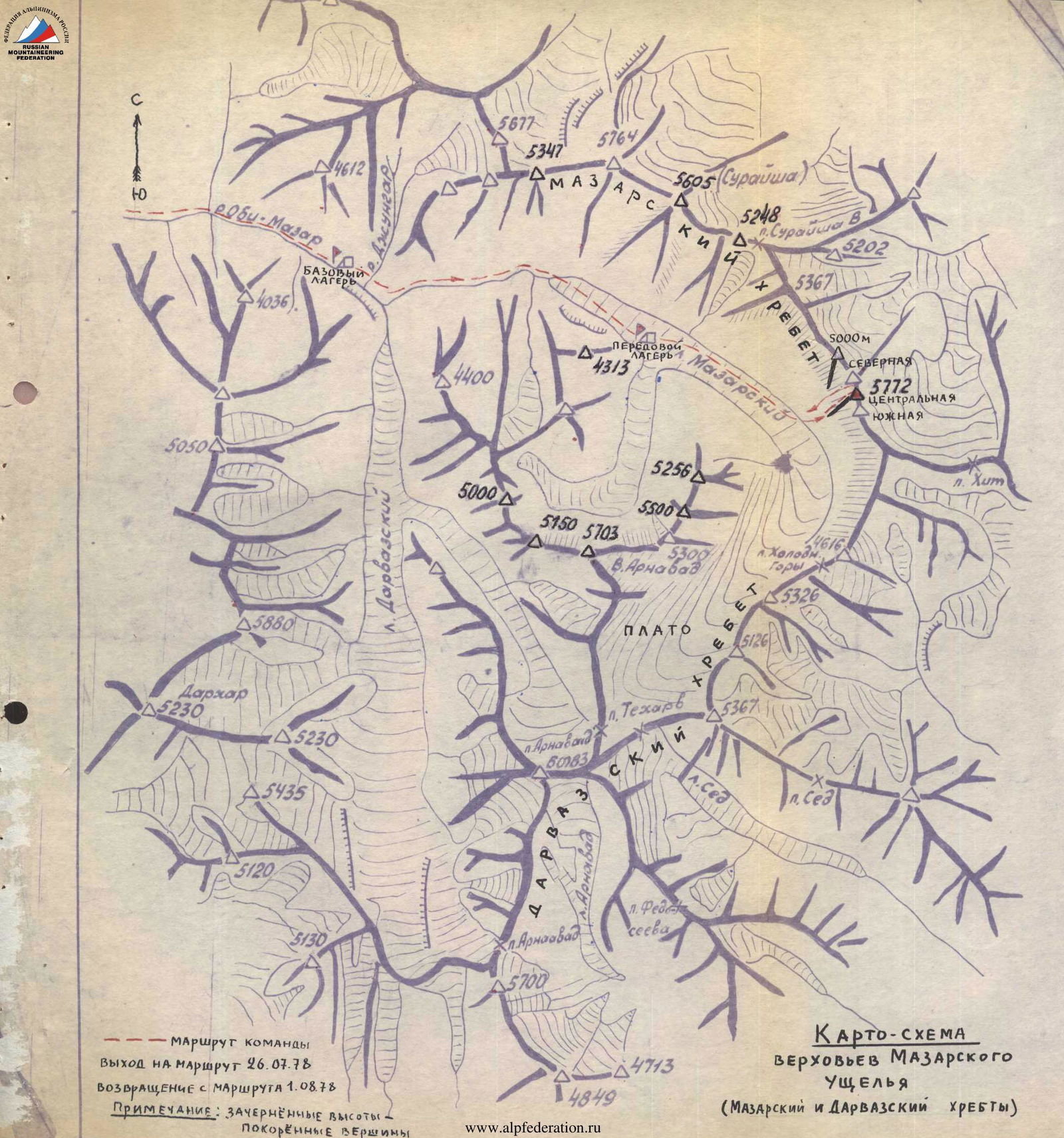
Map-scheme of the upper reaches of the Mazar Valley (Mazars and Darvaz ridges)
From the Mazar Valley, looking upstream, even from afar, three nearby located beautiful and high peaks are visible on the Mazar Ridge, dominating other peaks (photo 2). According to available map-schemes, these peaks are unnamed and are designated as a single massif with a height of 5772 m, although, in reality, it represents three separate peaks with extensive ridges and deep saddles between them. Since we lacked more specific data on the height of each peak, we conditionally decided to refer to these peaks by their orientation as central, northern, and southern. The 5772 m massif is the highest point of the entire Mazar Ridge. All three peaks of this massif are sharp with sheer walls and steep edges. There are no simple ascent routes from the Mazar Valley side.
Since, according to available information, the 5772 m massif remained unconquered, our team was unanimous in its desire to ascend this object within the framework of the society's championship.
Our choice directly fell on the conquest of the central peak, the ascent to which our team, due to considerations of logic, complexity, beauty, and maximum safety of the route, carried out along the steep southwestern edge extending upwards directly from the glacier almost to the summit. The descent from the summit was made along the northern ridge to the saddle with the northern peak of the massif and then along a snow-ice couloir to the Mazar Glacier (photo 1).
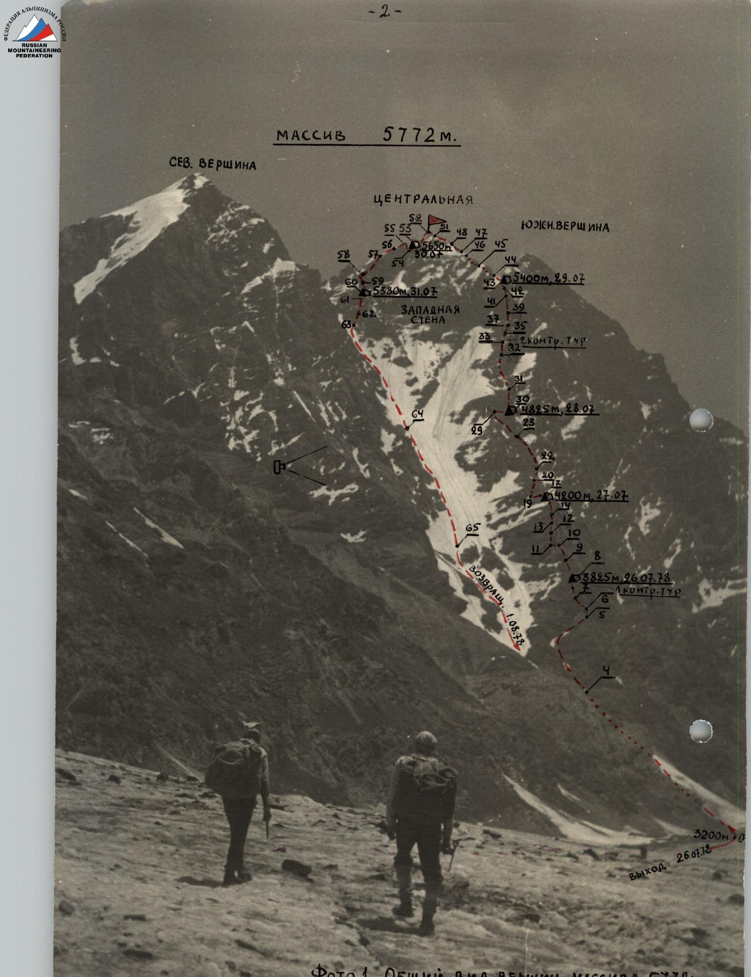
Photo 1. General view of the peaks of the 5772 m massif with the ascent route to the central peak along the southwestern edge. Point D — location on the southern ridge of Peak 5000 m, from where the profile of the southwestern edge of the central peak was photographed (photo 3) (Ascent passport on the reverse).
Team Preparation for the Ascent
The physical and technical preparation of team members for the ascent during the pre-season was conducted in the form of low-level section training, the level of which was monitored during participation in various competitions held by individual sections and the Regional Council of the Zenit Sports Society. From the moment the composition of the gathering was first outlined (April), training for candidates, including our team, was conducted centrally under the guidance of the coaching council. Directly in the mountains, the team conducted necessary training, made reconnaissance-acclimatization exits, a training ascent, monitored the condition of routes, practiced the tactical plan of ascent, and finally prepared the necessary equipment and supplies.
For training, acclimatization, studying the route, and photographing the profile of the main ascent route to the central peak of the 5772 m massif along the southwestern edge, our team предварительно made an ascent (approximately 4–5 category difficulty) on a nearby unnamed peak (Peak 5000 m), located in the Mazar Ridge west of its northern peak, the chosen object of the main ascent. The ascent to Peak 5000 m along the southern ridge, running in close proximity and practically parallel to the southwestern ridge of the central peak of the 5772 m massif, was for us a veritable "escalator" from which, with gradually increasing height, we were able to closely examine the relief of the entire southwestern edge of the central peak, make necessary sketches, and study the rockfall regime of the slopes within the upcoming ascent route. A photograph of the profile of the southwestern edge of the central peak, taken from the middle part of the southern edge of Peak 5000, with the ascent path marked, is shown in photo 3.
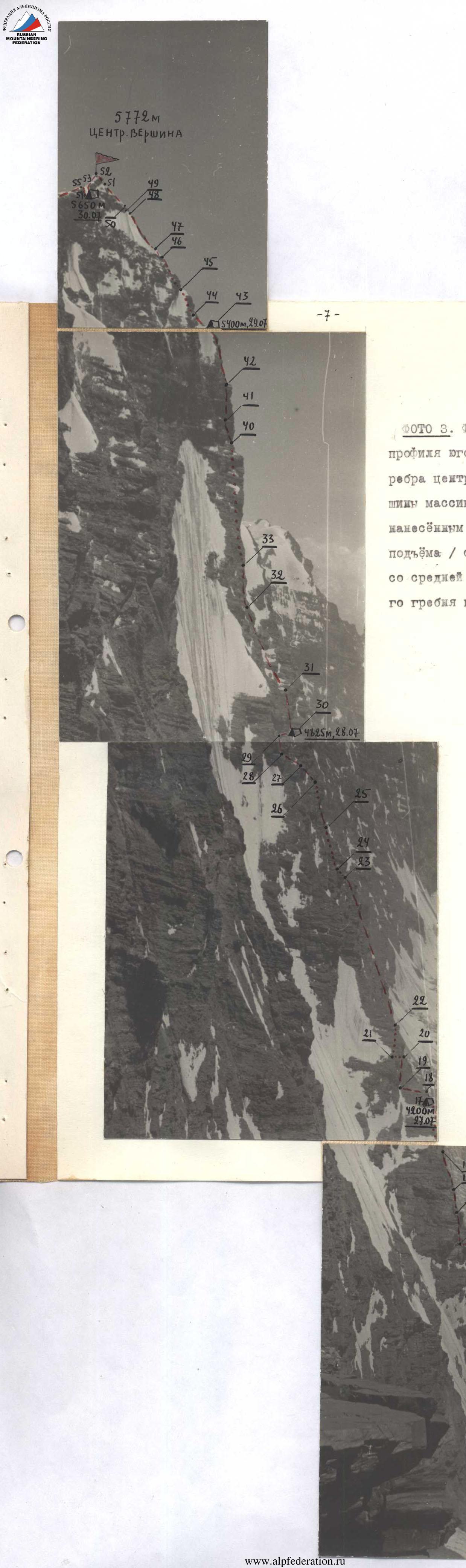
Photo 3. Photograph of the profile of the southwestern edge of the central peak of the 5772 m massif with the ascent route marked / taken from the northwest: from the middle part of the southern ridge of peak 5000 m.
Upon returning to the advanced camp for the main ascent, our team did not immediately start on the route but waited five days. Other teams from the gathering also departed from the advanced camp on the Mazar Glacier, with whom our team was linked by a unified plan of interaction, insurance, and observation. Therefore, in accordance with the ascent schedule of the gathering, between July 21 and July 26, our team served as an insurance group for teams that were on ascents during that period. Fortunately, the ascents were accident-free, so we gained additional time, during which our team was able to further prepare for its ascent. Being in the vicinity of our route, which was clearly visible from the advanced camp, we were able to maximally supplement our knowledge of it. Regular trips to the glacier in close proximity to the route, which we made to establish stable communication with teams on ascents, were typically combined with observations of the rockfall regime of the slopes within our route.
Approach to the Route
The path along the Mazar Valley starts from the end of the motor road at the village of Upper Sangvor, where the Mazar Valley begins. After crossing the bridge over the Obi-Khingou River, you enter Upper Sangvor. Here, you can hire pack transport, mainly donkeys. From here, the path to the base camp goes along the right (orographically) bank of the Obi-Mazar River. To the shrine of Khojati-Burk, the trail, regularly used by pilgrims, is in good condition. Beyond Khojati-Burk, the trail is worse but is mostly noticeable and passable for pack transport. The only serious obstacles are:
- crossings over two full-flowing and turbulent tributaries of the Obi-Mazar River, through which unloaded donkeys are led across early in the morning;
- for people and cargo, if there are no crossing logs, it is better to organize a suspension bridge.
The entire path from Upper Sangvor to the base camp near the Jun gar River can be completed in 3 days with well-coordinated work with the caravan.
From the base camp, the path to the upper reaches of the Mazar Glacier, where the "5772 m" massif is located, also lies along the right bank of the Obi-Mazar River.
- Within a quarter of an hour's walk, the Jun gar River flows, the banks of which are covered with a large amount of mudflow material. Crossing is done by wading or stepping on stones.
- Within ten minutes' walk is the sediment gauge, near which the Leningraders' camp was located in 1974.
- Further, the river valley narrows, and for the next hour, one has to walk along steep scree slopes along the river.
- Further to the tongue of the Mazar Glacier, the path goes along the flat banks of the Obi-Mazar River (3.5–4.5 hours from the base camp).
- We ascend onto the glacier to the left of the river flowing from the glacial grotto.
- Along the central moraine of the glacier, we move to the point of confluence with its left branch (from Peak Arnavad).
- On the median moraine, the advanced camp is located (5–6 hours from the base camp), situated at a height of about 3000 m. The location turned out to be very convenient for observation since almost all the routes of our gathering groups were visible from it (upper reaches of the Mazar Glacier, cirque at Peak Arnavad). The approach from here to any route takes 1.5–3 hours.
From the advanced camp, the path to our route lies across the center of the weakly disintegrated part of the open glacier to the clearly visible three peaks of the 5772 m massif.
Between the central and northern peaks of the 5772 m massif, a steep snow-ice couloir passes, which in its lower part merges with the couloir coming from the saddle between Peak 5000 m and the northern peak of the massif.
Directly from the glacier, to the right of this couloir, the southwestern edge begins on the central peak, which is visible almost to the pre-summit tower of the peak.
The path from the advanced camp to the route (to the base of the couloir) takes 1.5 hours.
Brief Description of the Route Passage (Explanations for Table № 1)
July 26, 1978. We start the ascent from the advanced camp at 6:00. After 1.5 hours of walking across the glacier, we are under the route. A short rest. We overcome the firn-ice slope (section 1) with a steepness of 35° in the lower part of the route in crampons. Despite heavy backpacks, we ascend quickly: crampons hold well on the firm snow that hardened overnight, and we are well acclimatized. According to the tactical plan, we need to reach the ice gully by 12:00 and enter the rocks of the southwestern edge. We approach the gully (section 2) at 11:00. Signs of rockfall danger are not yet observed. Having organized piton insurance, we quickly cross the gully and follow rocky ledges (section 3) to the first rocky wall (section 4). Since the backpacks are heavy and the wall is steep, the first person passes it in galoshes (photo 4). Behind the wall, the path flattens out and goes along a long rocky couloir (section 5), which divides the southwestern edge into two parallel counterforts. The lower part of the couloir is overcome along large scree and is passed fairly quickly, and then begins fine scree with sections of snow and water, which flows down from underfoot. The upper part of the couloir abuts steep rocks, so we exit onto the right counterfort and approach the next rocky wall (section 6). The average steepness of the wall is almost 80°, so we pass it without backpacks. The first person goes in galoshes. The wall is located slightly to the left of the counterfort; the end of the rope for pulling up backpacks has to be pulled separately using the first person of the second rope, without passing it through insurance carabiners (photo 5). The main 60 m rope is enough to pull the backpacks directly from the counterfort. After the wall, the route goes along rocks of medium difficulty directly up the edge (section 7), then along an osypnoy destroyed ridge (section 8), which is overcome easily without piton insurance. Ahead, a complex wall is visible, and since the day is already ending (17:30), we stop for a bivouac. Meanwhile, the V. Kremen — V. Efimov pair is busy arranging the bivouac, while the second pair (E. Korenev — A. Gerasimenko) goes further along the ridge to examine the upcoming wall and outline a variant for overcoming it. The pair returns to the bivouac from under the wall at 19:00. One rope of the complex section of the ridge is processed (section 10).
July 27, 1978. The rocks are cold; the sun has not yet illuminated them. An early start is not feasible. The first rope (V. Kremen — V. Efimov) exits the bivouac first, and the second rope (E. Korenev — A. Gerasimenko) packs up the bivouac and follows at 9:00. We quickly pass the simple section of the ridge (section 9) and the processed rocky ridge (section 10). The wall looks imposing. Ahead is a huge and steep internal corner. We pass it without backpacks. First, we traverse left along the right part of the wall directly to the internal corner (section 11), and then straight up along the left part (section 12). Creating artificial support points is required for passage. Climbing is very complex; the entire wall had to be passed by everyone in galoshes, as only two pairs were available, so the others had to be passed down the rope hung for pulling up backpacks. Backpacks are pulled up using a block, and a spare rope serves as a tug. After overcoming the wall (section 12), the path goes further along a complex edge (section 13). Climbing is tense since the rocks are steep inclined slabs with stones on them (photo 7). Special care and accumulated experience are required to avoid disturbing the stones during climbing. Thorough piton insurance is organized. After a short flattening at the end of the edge (section 13), another extensive rocky edge begins (section 14), after which the steepness and complexity decrease, and the next section of the route (section 15) is passed easily with insurance through individual rock outcrops. We approach a rock outcrop (a "boulder"), which is bypassed on the right along its eastern slope (section 16), mainly along osypnye ledges. The rocks are destroyed, and in places, wet and icy sections are encountered. Climbing is emotional since the slope steeply drops almost to the glacier, so thorough piton insurance is organized. Then, we ascend directly upwards to the ridge (section 17). At this section, the rocks are strong, and insurance is organized using rock outcrops. We exit onto the edge in a relatively simple area, but ahead is another imposing wall, which we decide to pass with preliminary processing. The day ends (17:00), and we set up a bivouac in this place, processing the wall during the remaining daylight. E. Korenev and A. Gerasimenko remain to prepare the bivouac, while V. Kremen and V. Efimov, having changed into galoshes, go to process the wall, taking necessary equipment and an additional rope with them.

Photo 6.
The two parts of the wall, merging, form a huge internal corner, into which we enter by:
- traversing left along the steep right part (section 19),
- then ascending directly up the corner (section 20).
The rocks are complex, but climbing in galoshes is pleasant, except for wet areas. We managed to process the internal corner (section 20) and return to the bivouac before nightfall.

Photo 7.
Photo 8.
July 28. We exit the bivouac at 9:00. We quickly overcome the simple part of the edge (section 18) and approach the beginning of the hung ropes. We overcome the complex section 19, and then the first rope (V. Efimov — V. Kremen) goes up immediately, while the second rope remains under the cover of a rocky outcrop on self-insurance, waiting for the first to ascend. Backpacks became lighter, and we are already accustomed to the route, so we pass these complex sections (sections 19 and 20) with backpacks along the hung ropes. Further, there is a series of simple sections (sections 21–24) both along the ridge and its right part, bypassing encountered rock outcrops, movement along which is mainly simultaneous with insurance through rock outcrops. Then, before another exit onto the ridge, we had to overcome quite complex rock sections (sections 25 and 26) with thorough piton insurance. Since the rocks are steep and fragile, the ascent along the internal corner of section 26 is carried out along the rope of the first rope (photo 9).
Photo 9.
Then, the route goes along a relatively gentle ridge (sections 27 and 28), which, gradually increasing in steepness, leads to a steep rocky wall of plate-like structure (section 29), which we overcome with thorough piton insurance. After this wall, the further path seems to be directly along the edge. However, we witnessed how stones thawing on the pre-summit slopes, getting onto a large ice slope to the left of us, accelerated and sometimes overlapped the edge. Therefore, for safety, we decided not to tempt fate and bypass the dangerous section on the right, although along a significantly more complex path. It was necessary to think about a bivouac, and an unprotected part of the edge was visible ahead. Therefore, without wasting time, we descended along the steep slope of the edge (section 30) onto a steep counterfort connecting higher with the edge. On the counterfort, we found a small platform under the cover of its overhanging rocks. The platform is small for a normal tent setup, but we are satisfied — it's safe. We attempt to expand the platform, but four people can't fit on it. One pair works on setting up the bivouac, while the other processes the further path (photo 10).
Photo 10.
The rocks (section 31) turned out to be very complex, with overhanging sections. We overcome them in galoshes. We have to drive in pitons to create artificial support points. By 20:00, V. Efimov descends, and we settle into the tent. We have dinner and then doze until morning.
| Date | № sections | Steepness in degrees | Length, m | Relief character | Difficulty | State | Weather conditions | Insurance, number of pitons | Passage |
|---|---|---|---|---|---|---|---|---|---|
| rock | ice | ||||||||
| July 28 | 18 | 45 | 60 | Rocky ridge | III | Destroyed, large scree | good | - | - |
| 19 | 40 | Rocky wall | V | Wet, smoothed slabs, ice sections | good | 4 | - | ||
| Horizontal traverse, lateral slope 80° | 60 | Internal rocky corner | V | Live stones, wet areas | good | 6 | - | ||
| 21 | 60 | Rocky slope | III | Destroyed | good | - | - | - | |
| Horizontal traverse, lateral slope 50° | 60 | - | III | - | good | - | - | ||
| 23 | 48 | 300 | Ridge of blocky-plate structure | III | - | good | - | - | |
| 24 | 20 | Rocky slope with osypnymi ledges | III | - | good | - | - | - | |
| Horizontal traverse, lateral slope 50° | 70 | 40 | - | IV-V | - | good | 4 | - | |
| 26 | 60–70 | 70 | Internal rocky corner | V | Fragile blocks and slabs | good | 7 | - | |
| 27 | 40 | 60 | Rocky ridge | III | Destroyed, osypnoy | good | - | - | |
| 28 | 45 | 60 | - | III | - | good | - | - | |
| 29 | 80 | 60 | Rocky wall | V | Inclined slabs | good | 5 | - | |
| 30 | 120 | Rocky slope | IV | With osypnymi ledges and ice sections | good | 10 (bivouac) | - | - | |
| Horizontal traverse, lateral slope 60–70° |
July 29. Due to the inconvenience of the bivouac, we exit onto the route quite late, at 10:00, but the rocks are still very cold. Feet freeze in galoshes. We ascend using clamps along the hung rope. The counterfort leads us back onto the ridge but much higher than its dangerous place. It's quiet. Everything is frozen. Nonetheless, we pass the next part of the ridge (section 32) of medium difficulty fairly quickly, organizing piton insurance on complex sections. The ridge of section 32 (photo 11) leads directly to the base of the pre-summit wall, to the right of which a wide internal rocky corner goes (photo). We decide to ascend along it (section 33). Having overcome some difficulties in transitioning into the corner, we then proceed along unpleasant inclined and wet slabs. In the upper part, the internal corner turns into a 20–30 m wall, passing which we exit onto a horizontal section of a short ridge. To our left is the pre-summit wall (photo 12), along which we will have to ascend. The wall, dropping off with a monolithic vertical edge towards us, initially frightens. We spend some time examining possible paths to overcome it and decide to exit left onto an inclined ledge crossing the wall from left to right above the intimidating edge. The processing takes the V. Efimov — V. Kremen pair. For this, we go left behind a rocky outcrop and, traversing the wall to the left (section 34), ascend along a steep internal corner (section 35). Having passed this corner, we again traverse a section of the wall to the left (section 36) to the base of the next internal corner (section 37), along which we exit to the beginning of the planned ledge (section 38). Leaving a hung additional rope on section 37, the pair returns to the starting point. Further, sections 34–37 are passed by the team in full. The ledge of section 38 turned out to be strongly inclined with individual ice sections and fine scree sliding underfoot, but nonetheless passable with proper insurance. The ledge (section 38) leads to the base of the next steep wall (section 39) with large hanging icicles. The rocks are steep and wet, so for reliability, we pass them rope by rope with thorough piton insurance. After this wall, we enter a simple rocky couloir with fine scree (section 40), at the exit from which we had to organize piton insurance. From this place, we ascend upwards along a not clearly expressed rocky counterfort (section 41). The rocks are of medium difficulty but fragile, so insurance is piton. The counterfort (section 41) leads to the base of a steep monolithic wall (photo 13). The rocks are wet and icy in places, so in one spot, we have to use pitons to create artificial support points. Having passed the wall (section 42), we enter a steep rocky and icy couloir (section 43). There's no other path, so we ascend along it with thorough piton insurance. Climbing is complex, and as a reward for the tense day, we unexpectedly exit onto a gentle part of the pre-summit ridge. The ridge is sharp, but we still find a place, which, having worked hard, we clear for a tent. Great fatigue is felt — after all, the height is almost 5500 m. We have dinner already in the dark and go to sleep, but sleep, apparently due to the height, was poor.
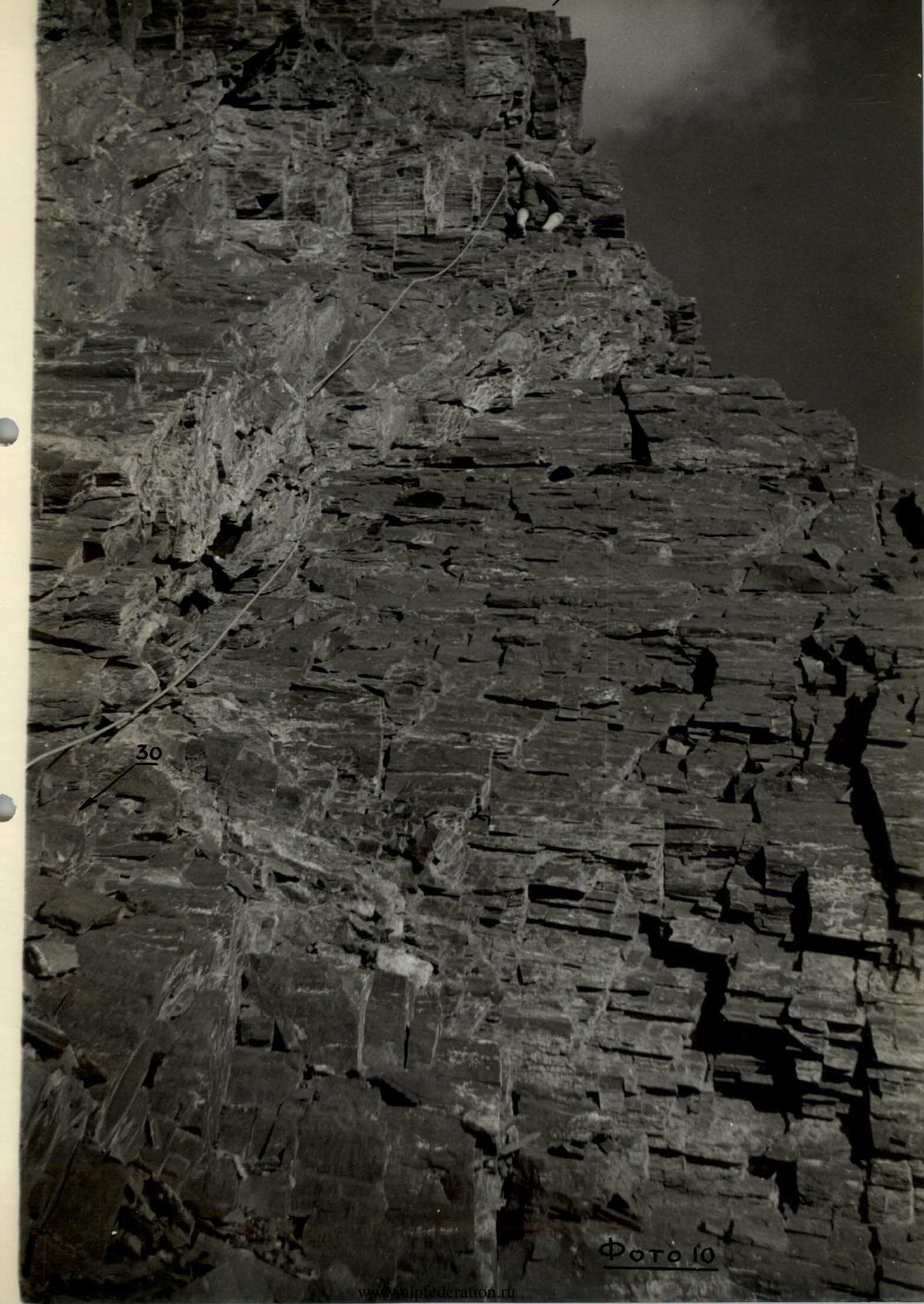
Photo 11.
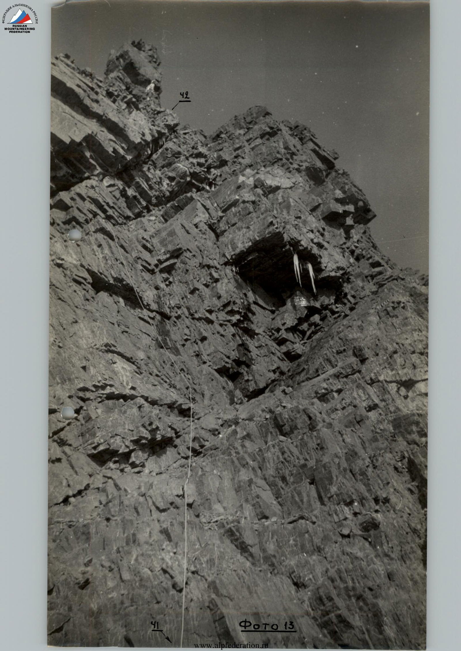
Photo 12.
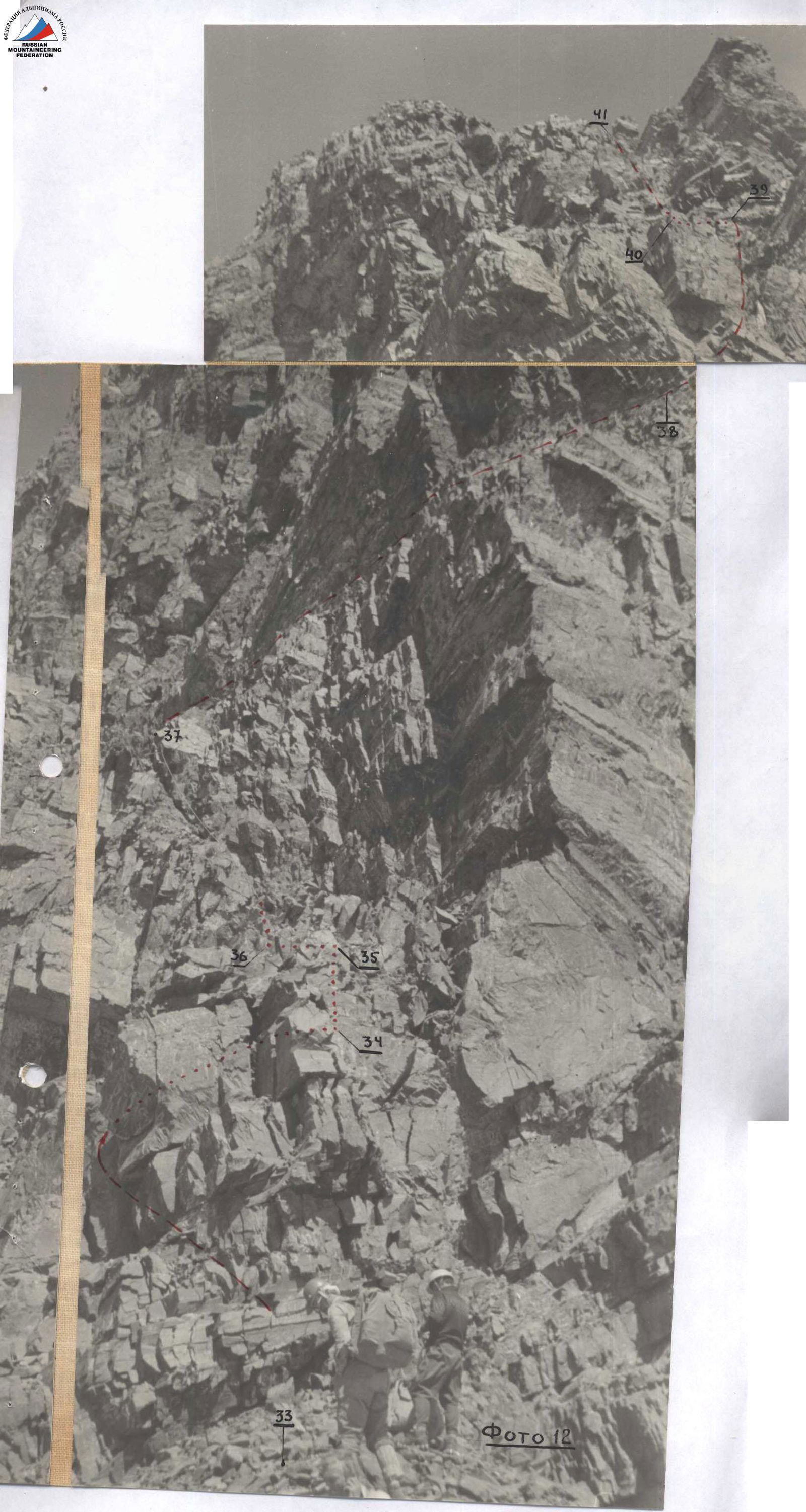
Photo 13.
July 30. In the morning, it's frosty, so we start our further journey late (11:00). A small section (section 44) of a relatively gentle but sharp and icy ridge leads to a rock outcropping (a "boulder"), which we bypass on the right (section 45). Then follows another rock outcropping, which we also bypass on the right (section 46). Unfortunately, the weather starts to deteriorate — strong wind, snow pellets. Further, there's a short ice slope (photo 14), gradually increasing in steepness to 60° (section 47), with insurance through ice screws. Behind the ice slope begins a long, steep, and sharp ice ridge (section 48) with fragile recrystallized ice. Its passage requires not only appropriate technique but also the highest psychological tension since there are steep kilometer-long cliffs on both sides of the ridge, and the strong wind does not subside, making it difficult to maintain balance. Fortunately, at the end of the second rope, it flattens out and becomes slightly wider (section 49), abutting a frozen rocky chimney (section 50). Having ascended the chimney, we again find ourselves on a sharp ice ridge (section 51), similar to the ridge of section 48 (photo 16). The steepness is less, but the emotions during its passage are the same. The ice ridge leads to a rather steep frozen rocky wall (section 52). 60 m of complex climbing and... further, only the sky. The summit! Time — 16:00. The summit is mainly rocky with a large snow-ice drift on the north. A thorough examination of the summit showed no signs of previous climbers. We write a note, for the first time set up a cairn, and allow ourselves a modest but well-deserved meal. 30 minutes of staying on the summit and then descent along the ridge towards the northern peak of the massif. The rocks are fragile and icy. To the northeast, ice walls drop off. Having descended two ropes along the ridge (section 53) from the summit, we reach a place where we can set up a tent. It's already 18:30; ahead, a steep rocky-ice outcropping is visible, and to the right, cornices are visible. To avoid risk, we decide to stop for a bivouac.
| Date | № sections | Steepness in degrees | Length, m | Relief character | Difficulty | State | Weather conditions | Insurance, number of pitons | Passage |
|---|---|---|---|---|---|---|---|---|---|
| July 30 | 44 | 30 | 60 | Sharp rocky-ice ridge | IV | Partly fragile | good | 2 | - |
| 45 | 70 | 60 | Bypass rocky outcropping along rocky wall | V | Fragile and icy | good | 3 | - | |
| 46 | 60 | 90 | Rocky wall | IV | Fragile, wet, and icy rocks | good | 4 | - | |
| 47 | 30–60 (average 45) | 30 | Ice slope | IV | Covered with snow | wind, pellets | 2 | - | |
| 48 | 40–60 (average 50) | 90 | Sharp ice ridge | V | With fragile weathered ice | - | 4 | - | |
| 49 | 30 | 10 | - | IV | - | -"- | - | - | |
| 50 | 80 | 5 |