- Climbing type — high-altitude technical
- Climbing area — Pamir, North spur of Darvaz Range
- Peak 5256 (unnamed), central buttress of NE wall
- Proposed difficulty category — 5B
- Route characteristics:
– height difference — 1900 m – length of sections with 5–6 cat. diff. — 1135 m – average steepness — 60°
- Pitons hammered: for belaying, for creating ITO (Intermediate Technical Object)
– rock 152 17 – ice 6 — – bolted —
- Total walking hours — 55
- Number of overnight stays and their characteristics — 6, in a tent on built platforms
- Participants:
Sedov German Konstantinovich, Candidate for Master of Sports — team leader Shchegolev Yuri Konstantinovich, Candidate for Master of Sports Arkhireev Alexey Ivanovich, 1st sports category Ovechkin Alexander Ivanovich, 1st sports category
- Team coach — Penchuk V.L., Master of Sports of the USSR
- Date of departure — July 22, 1978, date of return — July 28, 1978
 www.alpfederation.ru↗
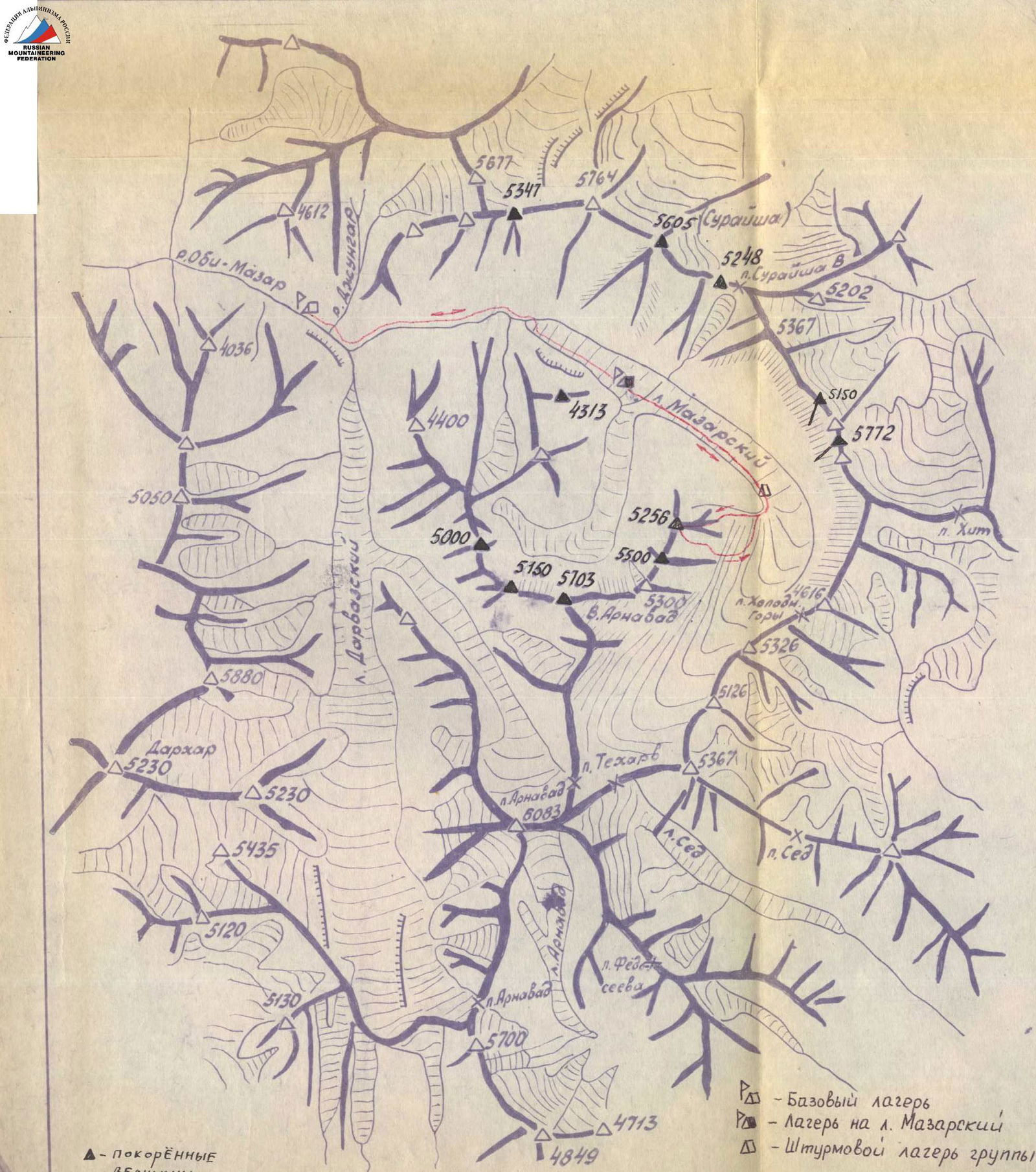
Brief description of the approach to the route
The upper base camp was located at the confluence of Mazarsky and Arnavad glaciers. From the base camp along the right (in the direction of travel) side of Mazarsky glacier. After 30 minutes, the slopes of peak 5256 m begin on the right.
Along the glacier, and then along the lateral moraine — exit to the upper cirque of Mazarsky glacier.
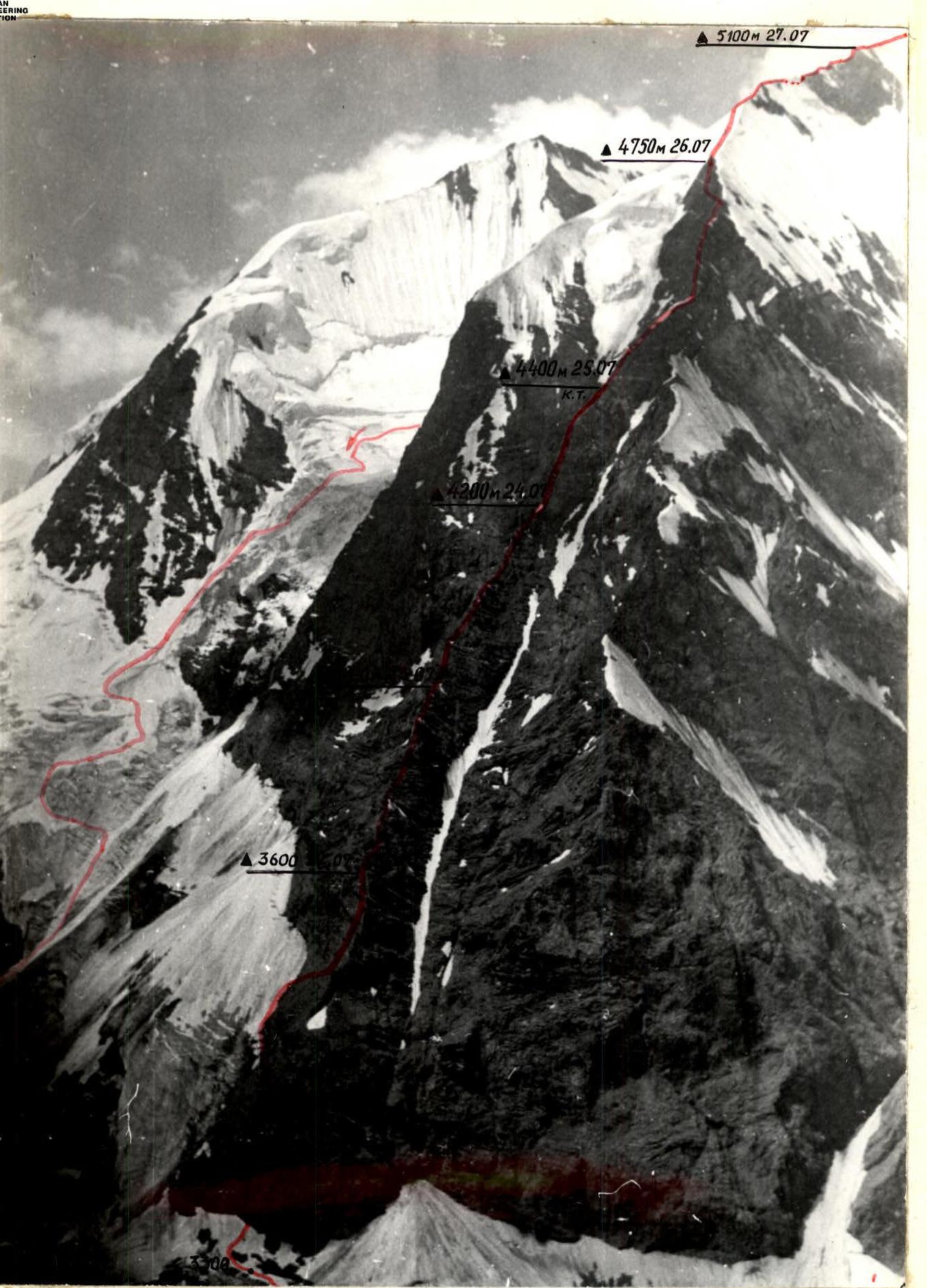
On the right is the eastern wall, representing three buttresses converging at the top into a single ridge leading to the summit.
The path to the central buttress goes:
– first along an open section of the glacier, – then along a broken closed glacier with numerous large crevasses, which are traversed along snow bridges.
The buttress stands out clearly on the wall and is easy to find. Further path does not require a detailed description, as once on the buttress, it is impossible to deviate from it: the couloirs on the right and left have almost continuous rockfall, even at night.

| I | 2 | 3 | 4 | 5 | 6 | 7 | 8 | 9 | 10 | 11 |
|---|---|---|---|---|---|---|---|---|---|---|
| Date | Designation | Average steepness in degrees | Length in m | Terrain characteristics | Difficulty | Condition | Weather conditions | rock | ice | bolted |
| 22.07.78 | 1 | 35 | 60 | Snow slope, inclined rock shelf 40° | 2 | Many "live" rocks on the shelf | clear | |||
| 2 | 70 | 60 | Wall, at the end talus shelf | 4A | Good holds for climbing, many "live" rocks on small shelves | |||||
| 3 | 85 | 20 | Inner corner, complex climbing | 5B | Destroyed rocks | 2 | ||||
| 4 | 45 | 30 | Slabs, shelves | 3 | Many "live" rocks | |||||
| 5 | 40 | 100 | Snow slope | 3 | ||||||
| 6 | 50 | 60 | Fine talus, slabs | 2 | ||||||
| 7 | 70 | 60 | Wall with small shelves, sharp ridge | 5B | Many "live" rocks | 3 | ||||
| 8 | 85 | 30 | Wall | 5B | 3 | |||||
| 9 | 50 | 30 | Wall, slab with few holds | 4A | 1 | |||||
| Departure time — 12:00, bivouac stop — 17:30. Total walking hours for the day (excluding rest, food, etc.) — 5 hours. Overnight conditions: platform built in 2 hours 30 minutes. |
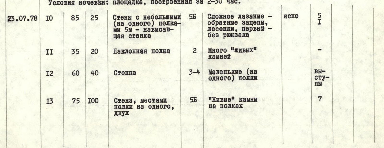
| I | 2 | 3 | 4 | 5 | 6 | 7 | 8 | 9 | 10 | 11 |
|---|---|---|---|---|---|---|---|---|---|---|
| 23.07.78 | 10 | 85 | 25 | Walls with small (for one person) shelves 5 m — overhanging wall | 5B | Complex climbing — reverse holds, ladders, first without a backpack | clear | 5 | 1 | |
| 11 | 35 | 20 | Inclined shelf | 2 | Many "live" rocks | — | ||||
| 12 | 60 | 40 | Wall | 3–4 | Small (for one person) shelves | ledges | ||||
| 13 | 75 | 100 | Wall, sometimes shelves for one or two people | 5B | "Live" rocks on shelves | 7 | ||||
| 14 | 80 | 60 | Wall, outer corner — 7 m, inner corner — 10 m | 5B | Monolith | 4 | ||||
| 15 | 85 | 50 | Wall with overhanging sections 3–5 m, 15 m — very complex climbing | 5B | First without a backpack | 3 | ||||
| 16 | 80 | 50 | Slabs with reverse holds, overhanging wall 5 m, wall 20 m 90°, inner corner on overhanging wall — 10 m | 5B | On slabs — "live" rocks | 4 | ||||
| 17 | 30 | 50 | Sharp ridge with short walls, steep inclined shelf | 3A | Many "live" rocks | Simultaneous movement, ledges | ||||
| Departure time — 8:00, bivouac stop — 18:00. Total walking hours for the day (excluding rest, food, etc.) — 9 hours 30 minutes. Overnight conditions: platform built in 3 hours. |
| I | 2 | 3 | 4 | 5 | 6 | 7 | 8 | 9 | 10 | 11 |
|---|---|---|---|---|---|---|---|---|---|---|
| 24.07.78 | 18 | 85 | 50 | Wall with two overhanging sections 5 m and 3 m | 5B | First without a backpack | 5 | 1 | ||
| 19 | 50 | 30 | Ridge | 3B | Destroyed, "live" rocks | simultaneous | ||||
| 20 | 85 | 50 | Wall of the buttress | 5B | First without a backpack | 5 | 1 | |||
| 21 | 15 | 20 | Shelf on the wall | 2 | "Live" rocks | |||||
| 22 | 75 | 50 | Wall with a black inner corner, overhang 5 m | 5B | In some places — very complex climbing. First without a backpack | 5 | 1 | |||
| 23 | 30 | 40 | Destroyed ridge | 2 | simultaneous | |||||
| 24 | 70 | 50 | Slab, ridge, overhang, crack | 5B | In some places — complex climbing due to hazardous destroyed rocks | 5 | ||||
| 25 | 50 | 80 | Slab, vertical chimney 75°, 15 m; wall 90°, 10 m; ridge | 4B | Destroyed rocks | 4 | ||||
| 26 | 70 | 40 | Wall, sharp ridge | 5B | 5 | |||||
| Departure time — 9:30, bivouac stop — 19:00. Total walking hours for the day (excluding rest, food, etc.) — 9 hours. Overnight conditions: platform built in 2 hours. |

| I | 2 | 3 | 4 | 5 | 6 | 7 | 8 | 9 | 10 | 11 |
|---|---|---|---|---|---|---|---|---|---|---|
| 25.07.78 | 27 | 85 | 50 | Wall, complex climbing | 5B | "Live" rocks on very narrow inclined shelves | clear | 6 | 1 | |
| 28 | 70 | 50 | Wall, very steep slab-like rocks with reverse holds, overhanging inner corner 7 m, very difficult climbing | 5B | Tile-like rocks | 4 | 1 | |||
| 29 | 20 | 20 | Ridge of the buttress | 2 | Destroyed rocks | simultaneous | ||||
| 30 | 85 | 50 | Wall, short overhanging sections, very complex climbing | 5B | 13 | 1 | ||||
| 31 | 65 | 50 | Couloir | 4B | Wet rocks, waterfalls | 2 | ledges | |||
| 32 | 60 | 20 | Slabs | 3 | "Live" rocks | |||||
| Departure time — 9:30, bivouac stop — 20:00. Total walking hours for the day (excluding rest, food, etc.) — 10 hours. Overnight conditions: platform built in 1.5 hours. |
| I | 2 | 3 | 4 | 5 | 6 | 7 | 8 | 9 | 10 | 11 | | :-: | :-: | :-: | | :------------------------------------------------------------------------------------------------------- | :----: | :------------------------------------------------------------------------------------------------------- | :------------: | :---: | :---: | :---: | | 26.07.78 | 33 | 55 | 40 | Chimney | 4A | Stoppers, "live" rocks | clear | 3 | | | | | 34 | 40 | 90 | Ridge, snow cornice on the right | 3B | Wet rocks | | 2 | | | | | 35 | 85 | 40 | Vertical wall 8 m, chimney 6 m, wall, very narrow chimney with a stopper, wall | 5B | | deteriorating weather | 8 | | | | | 36 | 80 | 50 | Wall | 5B | Many "live" rocks and large blocks | clear | 8 | | | | | 37 | 50 | 50 | Ridge, short walls | 4B | | | 3 | | | | | 38 | 85 | 30 | Slab, overhanging wall with two inner corners. Backpacks are pulled up | 5B | Initially monolithic, in the upper part complex climbing — "live" blocks | | 9 | 1 | | | | 39 | 60 | 120 | Rocks of medium difficulty (left side of the ridge) | 3B–4A | "Live" rocks, wet rocks | | | ledges | | | | 40 | 85 | 50 | Wall (left side of the ridge) — traverse | 5B | Wet, partly icy rocks, waterfall, complex climbing | | 2 | | | | | 41 | 60 | 120 | Ridge | 3B–4A | Climbing of medium difficulty | | 2 | | | Departure time — 9:00, bivouac stop — 19:30. Total walking hours for the day (excluding rest, food, etc.) — 10 hours. Overnight conditions: platform built in 1.5 hours.
| I | 2 | 3 | 4 | 5 | 6 | 7 | 8 | 9 | 10 | 11 |
|---|---|---|---|---|---|---|---|---|---|---|
| 27.07.78 | 42 | 60 | 50 | Ridge, snow cornice | 3B–4A | Wet rocks | clear | 2 | ||
| 43 | 35 | 50 | Snow ridge | 3B | Hard firn, sometimes ice | |||||
| 44 | 45 | 40 | Rock outcrop | 3B | Wet rocks | ledges | ||||
| 45 | 50 | 70 | Snow-ice slope | 5A | At the beginning of the section, small calga-spores, at the end — a thin layer of snow on ice | 1 | 3 | |||
| 46 | 60 | 40 | Ridge | 4B | On the right — a snow cornice. Wet rocks | 2 | ||||
| 47 | 70 | 50 | Wall | 5B | Wet rocks | 4 | ||||
| 48 | 20 | 40 | Ridge | 3 | On the right — a snow cornice. Wet rocks | simultaneous | ||||
| 49 | 60 | 95 | Ridge with short (7–10 m) vertical walls | 4B | 2 | |||||
| 50 | 35 | 120 | Sharp ridge, bypassing a depression along the snow | 4A | ||||||
| 51 | 50 | 30 | Slab | 5A | In the upper part on the slab — ice under a thin layer of snow | 2 | ||||
| 52 | 80 | 30 | Overhanging wall | 5B | Icy, "live" rocks, first without a backpack | 4 | 1 | |||
| 53 | 10 | 20 | Sharp ridge | 3 | Wet rocks, on the left — a slab 70°, on the right — a snow cornice | simultaneous | ||||
| Departure time — 10:00, bivouac stop — 20:00. Total walking hours for the day (excluding rest, food, etc.) — 9 hours. Overnight conditions: platform partially cut into the ice ridge. |
| I | 2 | 3 | 4 | 5 | 6 | 7 | 8 | 9 | 10 | 11 |
|---|---|---|---|---|---|---|---|---|---|---|
| 28.07.78 | 54 | 20 | 140 | Slabs, adjacent ridge, small (7–10 m) walls | 3B–4B | Wet rocks, hard firn, ice, cornices | clear | 2 | ||
| 55 | 180 | Wall, snow-ice slope | 2 | Hard firn, crevasses | ||||||
| 56 | 10 | 200 | Snow plateau | — | Wet snow, crevasses | |||||
| 57 | 40 | 180 | Snow-ice slope, ridge | 3A | Hard firn, crevasses, wet rocks | |||||
| Departure time — 9:30, reaching the summit — 11:55. Total walking hours for the day (to the summit) — 2 hours 30 minutes. Descent along the route, approximately 3rd category of difficulty, took 8 hours, 3 ice screws were hammered. |
Brief explanation for the table of sections
July 22. Departure on the route immediately after radio communication, which established that "all is well" with the groups on the route. Along the snow slope — exit to the left part of the buttress. To the left is a steep ice slope; exposed to rocks falling from the left couloir of the wall. To the right, the lower part of the buttress is exposed to rockfall from the right couloir. Rockfall, as observed over two days, occurs both day and night at irregular intervals.
Almost immediately — a short section of complex climbing. Further exit to a snow slope and along the edge of rocks and snow (sometimes open ice) — exit to talus. From the talus along a wall of complex climbing — exit to the buttress. The route further goes along the buttress — the safest ascent option, as the right and left couloirs have almost continuous rockfall.
– At 17:30, we reach a steep talus shelf, where a good bivouac platform was built in 2 hours 30 minutes.
July 23. The buttress is in the shade of the Mazarsy ridge and is lit up at 8:00 am. Very cold, clear weather. Immediately — very complex climbing with a short overhanging section. The first climber's backpack is lightened, and further along the route, the first climber went either without a backpack or with a lightened backpack. Often, all backpacks are pulled up.
– At 18:00, we stop on a sharp ridge before a complex wall with overhanging sections. – Processing the wall and building a platform for the tent continues for another 3 hours.
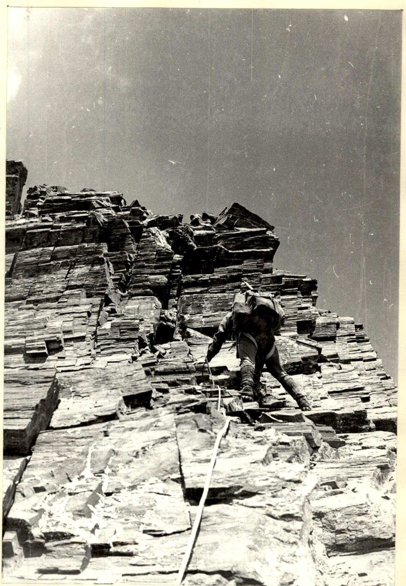
July 24. We depart late — at 9:30. Cold, but clear. We pass the section processed the day before. Further — steep, destroyed rocks. Sometimes short, gentle sections provide psychological relief. Great difficulties are caused by overcoming huge "live" blocks. Steep slabs with fine talus on them (literally — sand) also present a significant difficulty, as it is almost impossible to find cracks for a piton, and organizing belays here is a problematic task.
– At 19:00, we stop for a bivouac under a steep ascent of the buttress on a sharp ridge shelf. – After 2 hours of work, a decent platform was built, almost under the tent.
July 25, 1978. After three steps — ascents of complex climbing — we exit to a couloir on the left side of the buttress. In the couloir — wet rocks, sometimes waterfalls. Rapid progress does not save us from a cold shower. Exit from the couloir to slabs, and on one of the small shelves, we manage to build a bivouac in just 1.5 hours.
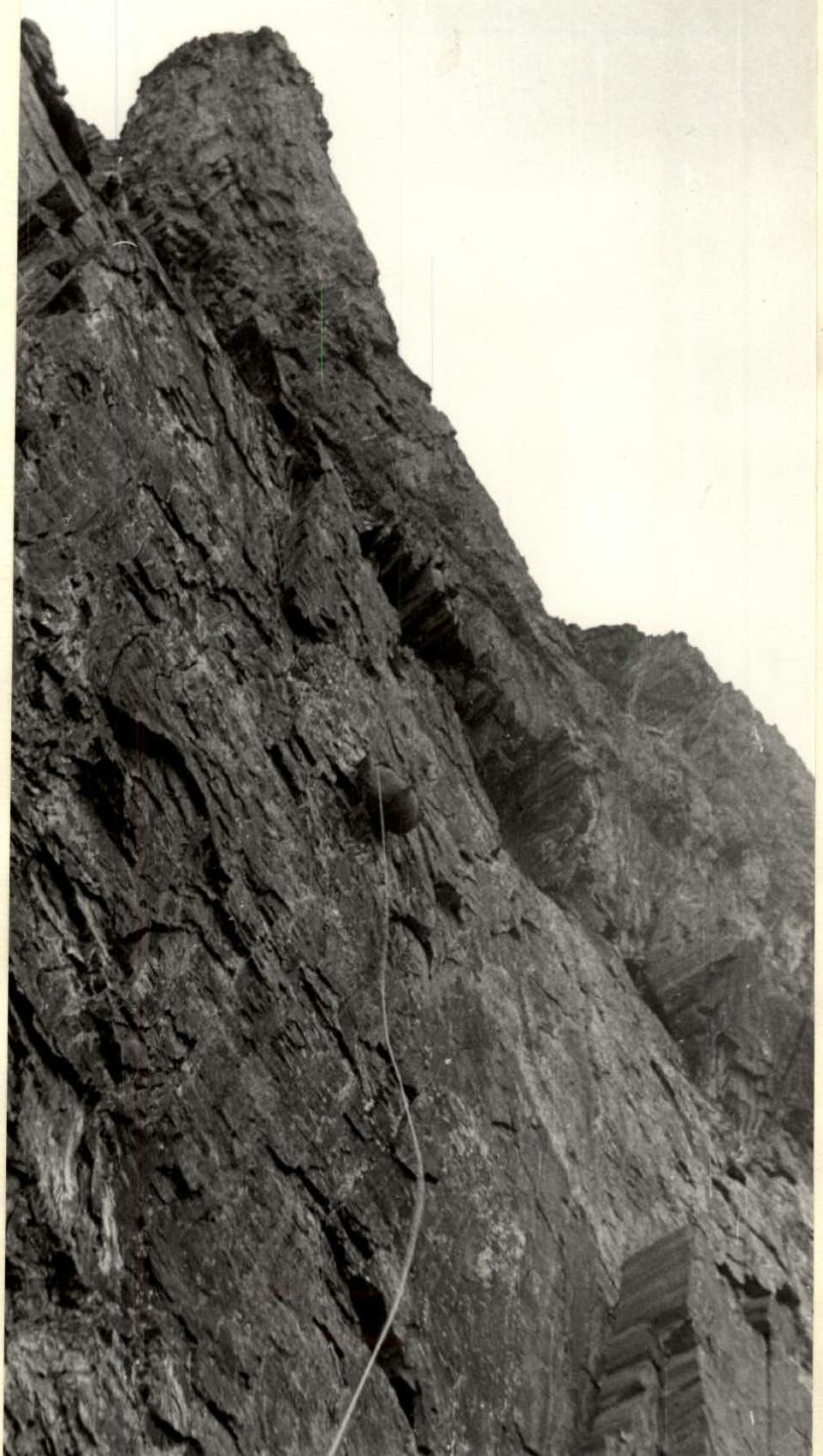
July 26. Departure at 9:30. Immediately — a chimney with pleasant climbing. A relatively small (compared to other sections) number of "live" rocks creates an illusion of monolithic rocks: we are already accustomed to a huge number of "live" rocks. Exit to a snow cornice on a very steep ridge. Further — usual combinations of steep, complex ascents — walls and short simple sections. The snow cornice is bypassed on the left (in the direction of travel). Here, a traverse to the left is impressive, bypassing the overhanging cornice. One has to climb along complex, icy rocks under a waterfall from the cornice. In some places — complex, psychologically difficult climbing.
July 27. On this day, the passage of the buttress was almost completed, and at the end of the day, the group reached the ridge of the "curtain" subpeak. The route tested us on two complex walls with wet, partly icy rocks, but it was already clear that the summit ridge would be significantly easier.
July 28. A long, but relatively easy ridge leads first to a subpeak and then to the summit (11:55). After a one-hour rest — descent to a snow plateau and further — exit to icefalls. Along the right (in the direction of travel) part of the icefalls (2 sports descents and 1 rappel) — exit to the glacier and further to the upper base camp.
Team captain
 Team coach
44.32
44:38. Pulling up the backpack