
PASSPORT
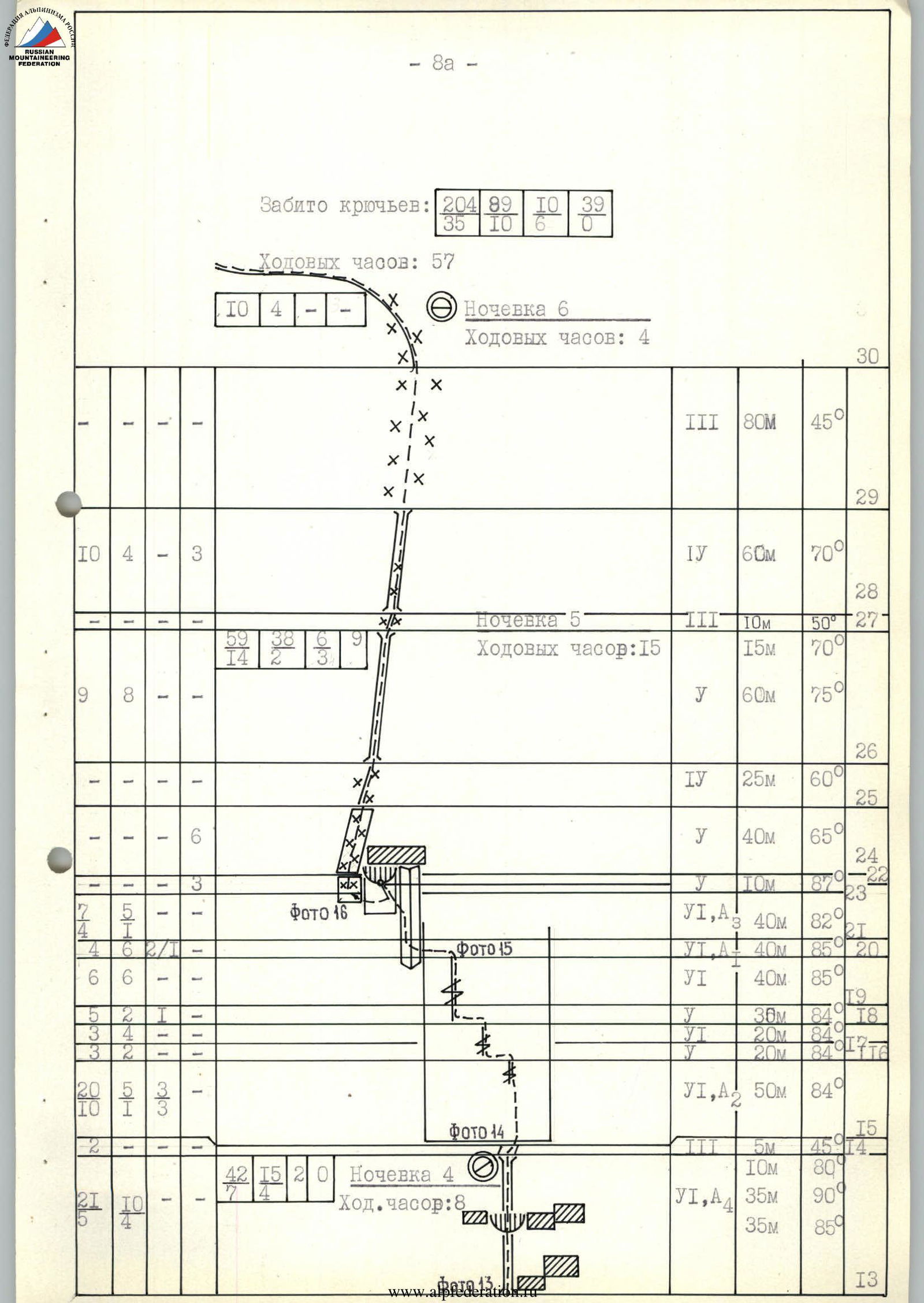
1. Class of first ascents 2. Pamir, Darvaz Range 3. Peak Suraysha, via the right bastion of the eastern wall 4. Proposed — 6B category of complexity, first ascent 5. Height difference — 1405 m, length: wall — 1675 m, ridge — 300–400 m. Length of sections with 5–6 category of complexity — 1095 m. Average steepness: ice — 52°, rocky part — 76°, overall wall — 88°, including 6B category of complexity 83° (4700–4910), 82° (5030–5270) 6. Pitons driven:
| rock | bolt | chocks | ice |
|---|---|---|---|
| 204 | 10 | 89 | 39 |
| 35 | 6 | 10 | 0 |
7. Team's working hours (excluding approach to the bergschrund — 2 hours): 57 hours. Days — 7. 8. Nights: 1st–2nd–3rd — four in tents, two on ledges (sitting); 4th — platform for six, laid out with the help of hammocks, filled with snow, sand, stones (semi-reclining); 5th — two in a cave, four on a platform carved on a snow ridge; 6th — platform for six on a snow ridge. 9. Leader: Pershin Valery Nikolayevich, Master of Sports
Team members:
- Vinogradsky Evgeny Mikhailovich, Master of Sports of International Class
- Ostanin Viktor Vasilyevich, Candidate for Master of Sports
- Mamaev Sergey Vladimirovich, Candidate for Master of Sports
- Shukhman Sergey Vladimirovich, Candidate for Master of Sports
- Pinus Alexander Mikhailovich, Candidate for Master of Sports 10. Coach: Efimov Sergey Borisovich, Honored Master of Sports
Entry to the route: July 18, 1986.
Summit — July 24. Return — July 25
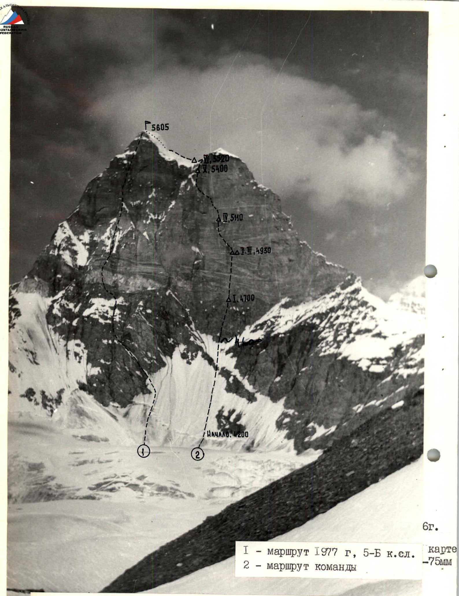
Photo 1. General photo of the summit. Taken from the moraine of the glacier on July 13, 1986, 10:00. Shooting point on the area scheme — №1. 3900. Distance 2.2 km. Lens — T-22, F — 75 mm
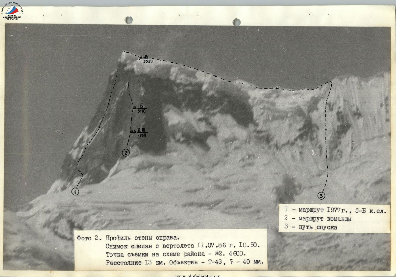
Photo 2. Profile of the wall from the right. Photo taken from a helicopter on July 11, 1986, 10:50. Shooting point on the area scheme — №2. 4600. Distance 13 km. Lens — T-43, F — 40 mm.
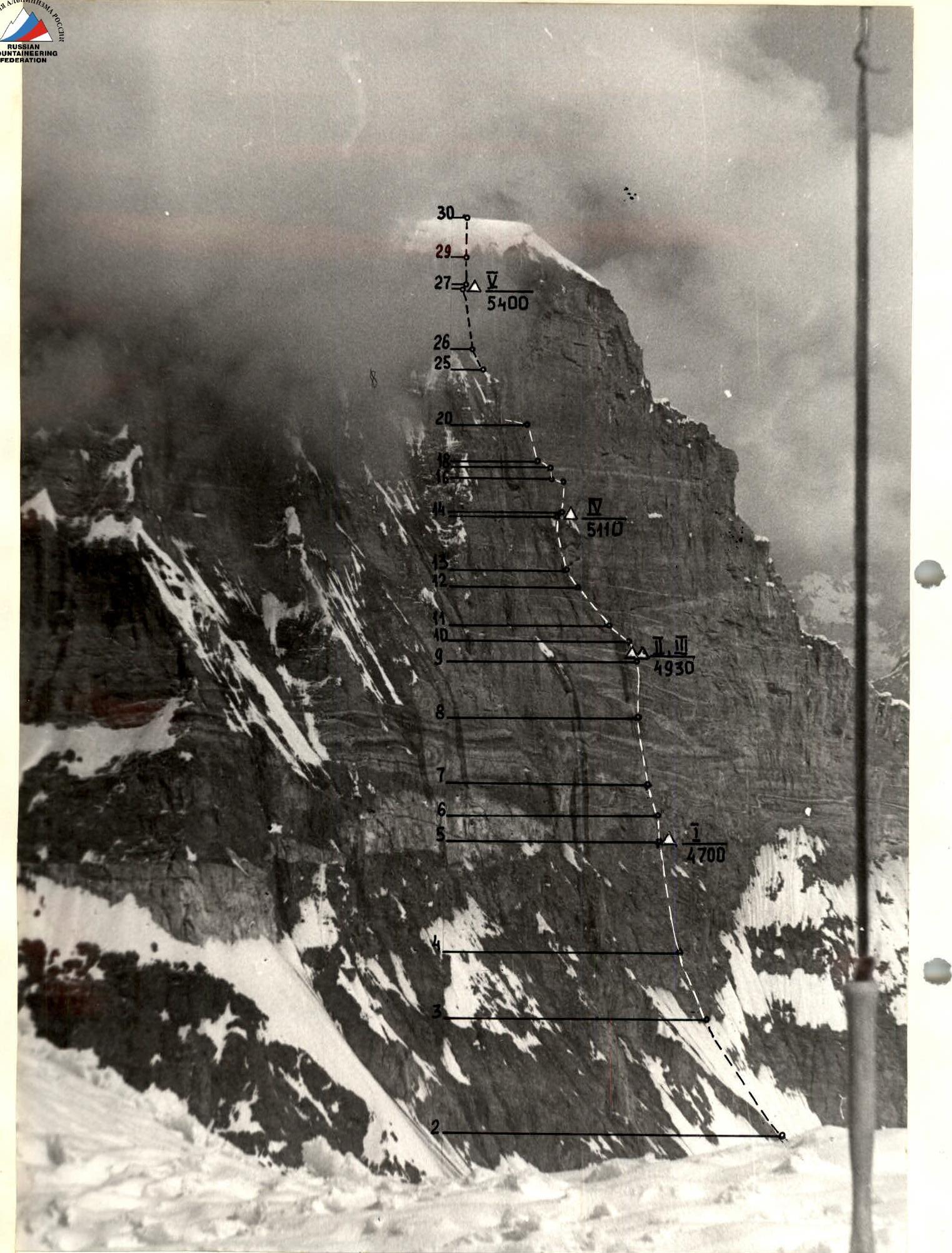
Photo 3. Profile of the wall from the left. Photo taken from the western ridge of Peak 5248 on July 14, 1986, 11:30ns. Shooting point on the area scheme — №3. 4500. Distance 1 km. Lens — T-43, F — 40 mm.
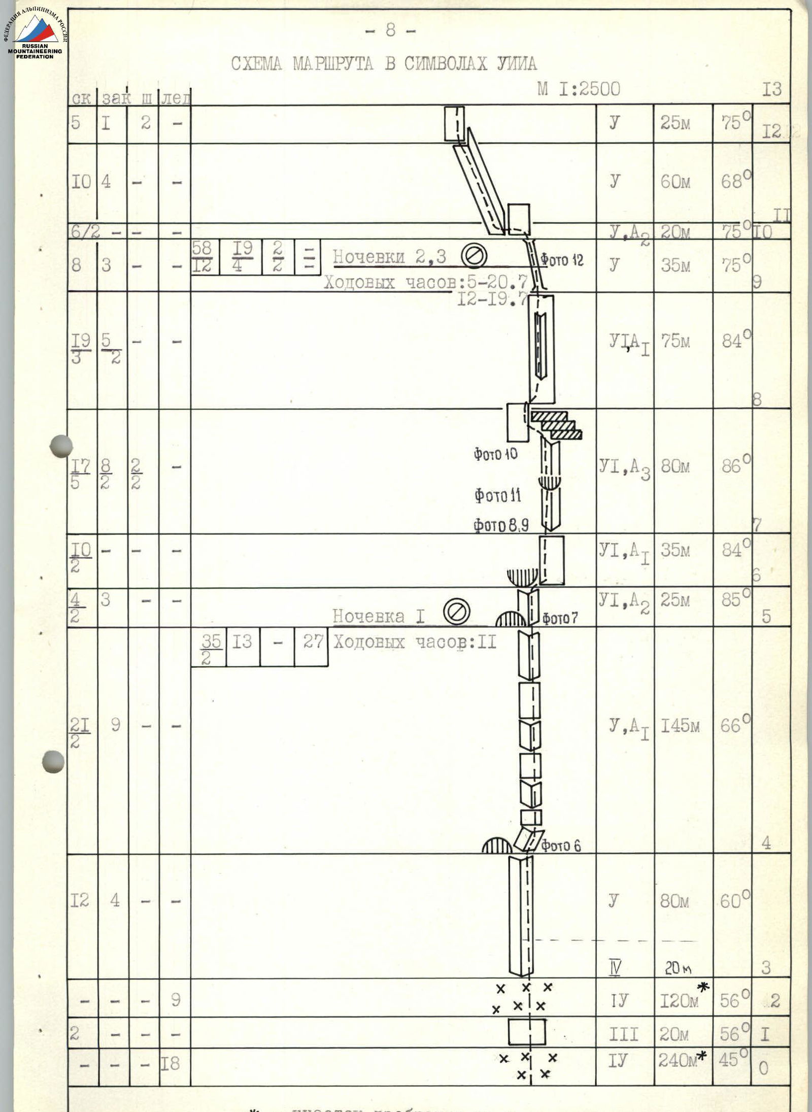
ROUTE PROFILE

 ← — path of the team's movement B — base camp Δ — observer camp (storming) O — shooting point
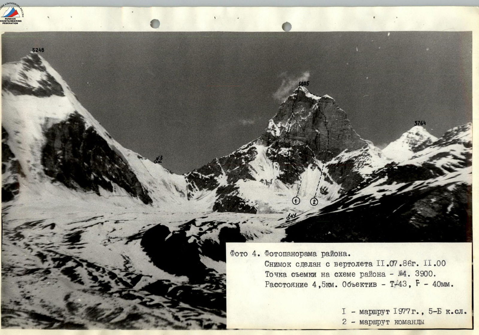
Photo 4. Photopanorama of the area. Photo taken from a helicopter on July 11, 1986, 11:00. Shooting point on the area scheme — №4. 3900. Distance 4.5 km. Lens — T-43, F — 40 mm.
1 — 1977 route, 5B category of complexity 2 — team's route
Brief overview of the ascent area
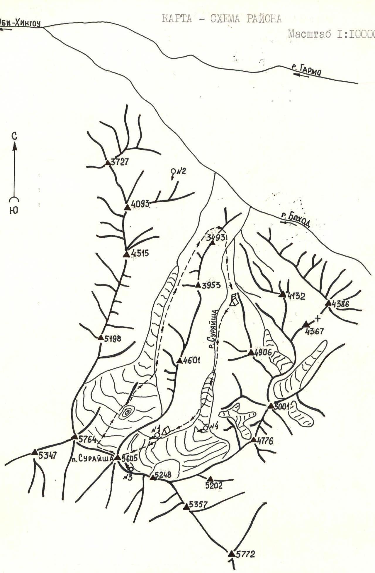
Peak Suraysha is located at the junction of the Mazar and Darvaz ranges in the Central Pamir.
The beautiful two-peaked summit — Peak Suraysha — is bounded by sheer bastions of the eastern wall, closing the eponymous gorge. The southwestern and northwestern walls are also steep. The northwestern wall has powerful ice ledges in its upper part. There are no easy descent routes from the summit. The northern and southern ridges are steep, long, and technically challenging. The only acceptable descent route is from the saddle of the western ridge to the northwest along a 600-meter ice wall with a slope of about 60°.
The peak, significantly rising above the three ridges emanating from it, is located at a distance from the neighboring peaks, and is therefore a natural barrier to air masses (mainly from the west and southwest). Apparently, that is why, throughout the observation period (from July 2 to July 24), the peak is free from clouds only during rare, mostly morning, hours. Even on exceptionally clear days, a cloud or mist hangs over the summit.
The area is practically undeveloped. Most of the peaks in the area are unnamed and await their conquerors. The team of the Ukrainian Republican Society "Avangard" led by S. Bershov made a first ascent to Peak Suraysha in 1977 as part of the USSR Championship, via the eastern wall, along its left part. Since then, the area has not been visited by climbers.
The eastern wall, especially its right part, is practically free of snow due to its steepness. In addition to the route climbed by the Ukrainians, it is possible to lay out several complex routes on the wall. Even the ridges bounding the wall to the north and south are serious objects for ascents. A logical continuation of the development of the eastern wall is the passage of the right bastion along the center.
It was this route that was chosen by the team as the object of ascent for the USSR Championship in the class of first ascents.
The ascent object is about 30 minutes of helicopter flight from Jirgatal. Other modes of transport are less suitable for reaching this area. By car, you can reach Sangvor Upper, but the further 50-kilometer journey on foot or using pack animals is hampered by the lack of good roads and crossings over numerous turbulent rivers.
The base camp was set up in the Suraysha river gorge, a 4-hour walk from the eastern wall of the peak. The approach along the glacier and moraines does not present any particular difficulties. A tent for observers was set up directly under the wall on the coastal moraine of the glacier.
Tactical actions of the team
In accordance with the tactical plan, on July 18, 1986, the team left the storming camp at 6:00 with the aim of reaching the bergschrund by 8:00 and passing the ice in the safe morning hours, away from rockfall. The ice was traversed by autonomous rope teams using ice screws screwed in by the leading rope team. The ice screws were handed over to the first rope team as they ascended.
When working on the wall, the tactical actions were as follows:
- Five backpacks were prepared.
- The first climber moved without a backpack on a double rope (one with UIAA marking) using an absorber, and fixed one of the ropes as a belay.
- The rest moved along the belay ropes (R4–R29) with a backpack, with upper or lower belay.
- Backpacks were carried on the back or under the feet, depending on the steepness of the section (photo 34).
- Rappel was not used.
- A leading rope team was appointed for each day.
The nature and structure of the rocks — steep sandstones, very fragile by their nature, which the team encountered for the first time — made adjustments to the team's years-long tactical actions. The high physical and psychological load associated with overcoming such rocks did not allow the leader to work a whole day. Therefore, the usual scheme, when the first ascender was appointed for the whole day, was changed. The leader was changed either at the request of the first ascender or by the leader when signs of fatigue were observed.
The leaders were:
- Pinus (R1–R3, R30, R31)
- Mamaev (R4, R5, R10, R12, R16–R21)
- Shukhman (R6–R9, R13–R15, R22)
- Ostanin (R11, R23–R29)
Changes were made to the tactics of passing individual sections to increase safety (sometimes at the expense of speed):
- As a rule, only one person was on the belay rope, although there were intermediate belay points.
- On sections with particularly destroyed rocks, when the route went vertically (R8, R14), all team members had to stand and carefully watch the first climber.
- If necessary, belay points were re-equipped (for example, the first few meters on section R13, passed by Shukhman, showed that rocks from under the first climber would fall on the belay point. It was necessary to abandon the convenient place and organize a belay point on a smooth wall using two bolt pitons three meters to the right). The "carrots" were very useful and were sometimes hammered directly into the rock. The measures taken allowed the team to complete the route without falls or injuries.
A detailed study of the route before the ascent allowed the team to initially follow the tactical plan accurately. On the first day, they reached the planned bivouac by 16:00. The location was safe, at the base of a hanging light niche. After resting, Shukhman (first) and Ostanin processed two ropes (R6, R7) from 18:00 to 21:00 (photo 7).
On July 19, having overcome the belt of banded rocks — very steep and destroyed — they reached the 2nd bivouac, planned according to the main variant, at the base of a G-shaped internal angle. Shukhman, who worked first, was replaced by Mamaev at the end of the day (after R9). The bivouac was in a chimney under the protection of its right (along the route) overhanging wall (photo 12).
The weather subsequently made adjustments to the movement schedule:
- On July 20, it was necessary to use a reserve day. It had been snowing all night, and snow and fog continued in the morning.
- At 12:00, a "window" appeared. Taking advantage of the temporary improvement in the weather, they decided to process the further path as far as visibility and the condition of the rocks would allow.
- From 13:00 to 17:00, Ostanin and then Mamaev processed R11 and R12 and reached under the "crown".
- Movement on icy, snow-covered rocks — in crampons.
- The rest of the team arranged the bivouac and tried to dry their clothes.
- In the evening, it snowed again, and there was fog.
On July 21, by noon, there were clearings that allowed them to continue the ascent, and by evening, they reached the planned bivouac on the "crown". There was no expected platform. The tent was set up on an artificially created platform using stones and hammocks. They sat tightly but were warm.
On July 22, the day was tense because the processing could not be done the day before (the working day was shortened by bad weather). To fit into the schedule, they had to work until dark, taking advantage of the fine weather. They had to change leaders twice: Mamaev was replaced by Shukhman on R22, and Ostanin finished the working day.
The next day, they rested well — two in a cave, four in a tent — and the exit on July 23 was late. Again, snow and dense fog. The day before, it seemed as if they had "stolen" a day from the bad weather.
On the pre-summit ridge, the fog intensified. The lack of visibility led to the danger of further movement. It was decided to spend the night and reach the summit in the morning. The possibility of reaching the summit on the 6th day (not counting the reserve day) was provided for in the tactical plan, albeit for a different reason.
The presence of hammocks and a tent allowed the team to restore their strength quite well on bivouacs both on the wall and on snow.
The diet consisted of hot food in the morning and evening, and a snack during the day. The food was calculated at 450 grams per person per day.
Communication with observers via a "Vitalka" radio station was generally stable. On July 21, when the audibility decreased, they replaced the power source, and the communication was restored. Angle measurements and altimeter readings were periodically taken.
* — the level is not shown to scale
Description of the route by sections
R0–R1. Ice "board" with a steepness of 45°. The bergschrund is overcome along an ice bridge. Insurance through ice axes. Movement by independent rope teams using pitons screwed in by the leading rope team. R1–R2. A strip of несложных разрушенных скал. R2–R3. Ice slope with a steepness of up to 56°. Entry to the base of the belt of dark rocks. R3–R4. Belt of dark rocks. Not very steep, but heavily destroyed rocks, covered with sand. Movement along the right side of an indistinctly expressed internal angle towards a smooth hanging slab. R4–R5. Continuation of the belt of dark rocks. The beginning of the section along the internal angle at the base of the smooth hanging slab (photo 6). Further towards the light niche along a series of internal angles and walls. "Carrots" are often used for organizing insurance. At the base of the light niche, there is a safe place for a bivouac, but there is no platform for setting up a tent. Managed to lay out two platforms for a sitting bivouac, four in hammocks. 1st control point. R5–R6. Internal angle closed at the top by a hanging slab (photo 7). Sandy rocks, holds crumble under hands. Exit from the angle under the hanging slab to the right. Use of IT. R6–R7. "Belt of banded rocks". Steep, fragile sandstone rocks. Holds are covered with sand. There are few places for organizing reliable insurance points. "Carrots" are often used. Sections R6 and R7 were processed on July 18. R7–R8. Internal angle with an overhang in the middle part, closed at the top by a three-tiered cornice with a ledge of up to 2 meters. Complex climbing using IT, deflects to the left. Requires extreme caution from all team members. There is nowhere to hide in case of rockfall. Entry from under the three-tiered cornice to the left along a sheer slab without cracks using three bolt pitons as IT. One of the key sections of the route (photos 8, 9, and 10). R8–R9. Slab, in the middle part, slabs form an internal angle with the slab. Common to sections R6–R9 — complex coordination climbing associated with overcoming very steep sections of fragile sandstone rocks, combined with difficulties in organizing reliable insurance points. Loading supports along the rock or spacers — are preferred; pulling off supports or loading them for separation — are practically excluded. R9–R10. Wide chimney with many loose rocks and sand at the base. The chimney leads to the base of a G-shaped internal angle. In the middle part of the chimney, there is a bivouac for four in hammocks, for two — a sitting bivouac on two ledges carved in loose, layered (like slate) rocks (photo 12). R10–R11. Traverse along snow-covered, icy slabs after bad weather. Rocks are smooth, with few holds and cracks for driving pitons. Climbing in crampons on this and the subsequent sections. R11–R12. Internal angle, the right face of which is a sheer wall. Movement along the left face. Snow-covered, icy, smooth rocks. The relief is very inconvenient for movement due to the double slope — along the direction of movement and to the left. R12–R13. Strip of destroyed steep rocks. R13–R14. Exit to the "crown". Internal angle- chimney of increasing steepness with an overhang in the middle part. Caution! — loose rocks in the form of "feathers", as if stuck in the rocks. Powerful gray-blue cornices remain on the right (photo 13). One of the key sections of the route. On the "crown", there is a semi-reclining bivouac in a tent on a platform constructed with the help of hammocks filled with snow, small stones, and sand. 2nd control point. R14–R15. Snow-covered rocks of the "crown" top. R15–R16. Base of the "mirror". Almost sheer slab with few thin cracks. Use of IT. Mainly, leaf-shaped pitons and several bolt pitons are used. Rocks are strong (photo 14). At the top of the section, there is a 10-meter crevice. R16–R17. Traverse towards the base of the slab. R17–R18. Slab. Again, sandy rocks. Holds literally crumble under hands. R18–R19. Traverse towards the next slab. R19–R20. Series of slabs leading to an internal angle bounding the "mirror" on the left. R20–R21. Traverse to the next internal angle, closed by a powerful cascade of gray-blue cornices, towards a strip of rime ice. Common to sections R17–R21 — very complex climbing due to the structure of the "mirror" rocks. Rocks are covered with a kind of "armor" of slabs — flakes facing down, a kind of "tiles", with a steepness of 83–85°. Cracks for driving pitons and chocks are present, but due to the above reason, there are few places for organizing reliable insurance. The results of tapping sometimes force abandoning the use of conventional pitons and chocks (even if there are cracks) and driving a bolt piton into a monolithic section of rock (photo 15). It is necessary to be extremely attentive and cautious. R21–R22. After the traverse, it was not possible to move directly under the strip of rime ice, as the snow-covered rocks are steep and heavily destroyed. Movement along steeper but stronger rocks at the base of the gray-blue cornices to the right of the rime ice. At the beginning of the overhang — a pendulum to the left onto the ice. R22–R23. Pendulum. Previously, the leader was changed. Ostanin (while the section was being processed up to the pendulum) put on crampons and prepared ice equipment. R23–R24. 10-meter section of almost sheer rime ice, very thin layer at the bottom — ice crust on rocks (photo 16). R24–R25. Strip of rime ice, but with less steepness. Exit to the left edge of the bastion. R25–R26. Edge of a snow ridge. Exit to the base of a chimney. R26–R27. Wide chimney, rocks are snow-covered after bad weather, and there is rime ice in some places. Movement is still in crampons. Exit to a snow ridge. Bivouac: four in a tent, two in a cave. R27–R28. Snow ridge. Exit to the base of a gully. R28–R29. Icy gully. Rime ice, movement on front points of crampons. Insurance with the help of ice screws or rock pitons driven into the right wall of the gully. Exit to a snow "roof" of the pre-summit. R29–R30. Snow slope. Exit to the pre-summit. Further along the ridge towards the summit. Bivouac in a tent due to lack of visibility (dense fog). R30–R31. Snow ridge. Summit.
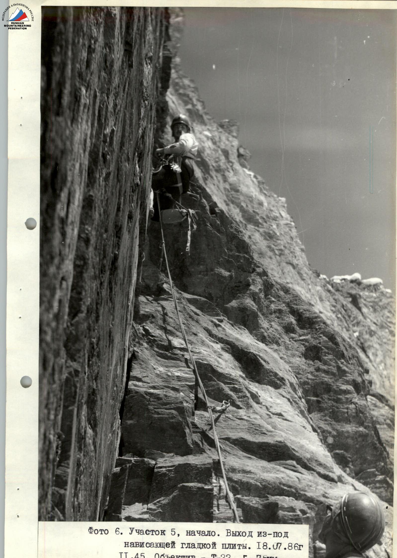
Photo 6. Section R5, beginning. Exit from under the hanging smooth slab. July 18, 1986, 11:45. Lens — T-22, F — 75 mm.
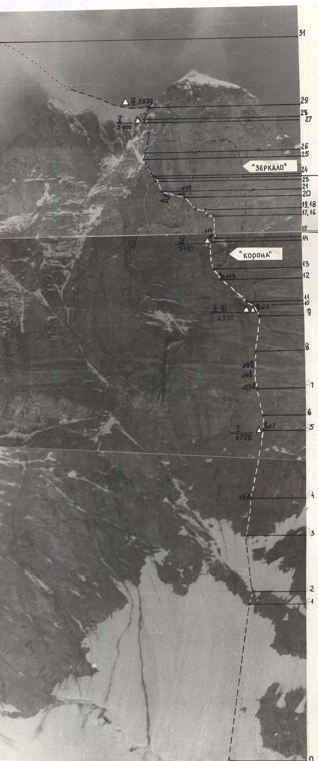
Photo 5. Technical photograph of the route. Taken from the moraine of the glacier on July 22, 1986, 10:00. Shooting point on the area scheme — №1. 3900. Distance 2.2 km. Lens — Jupiter 37A, F — 135 mm.
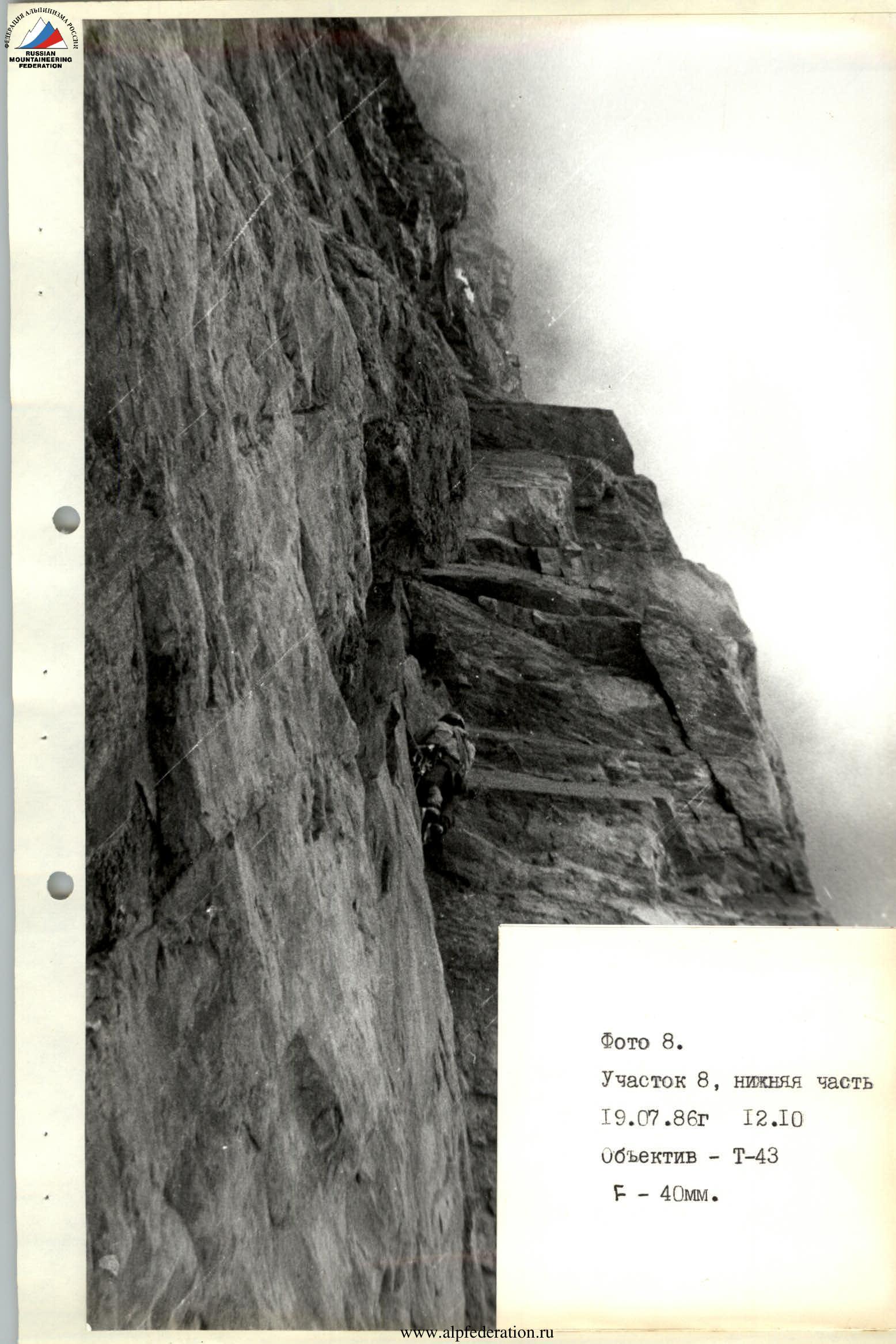
Photo 8. Section R8, lower part. July 19, 1986, 12:10. Lens — T-43, F — 40 mm.
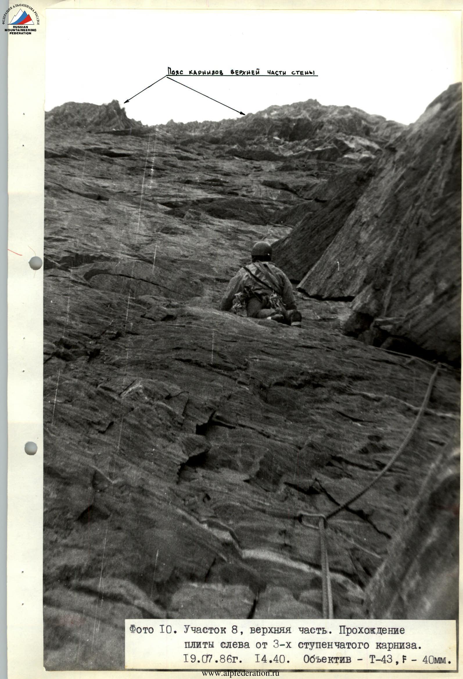
Photo 10. Section R8, upper part. Passing the slab to the left of the 3-tiered cornice. July 19, 1986, 14:40. Lens — T-43, F — 40 mm.
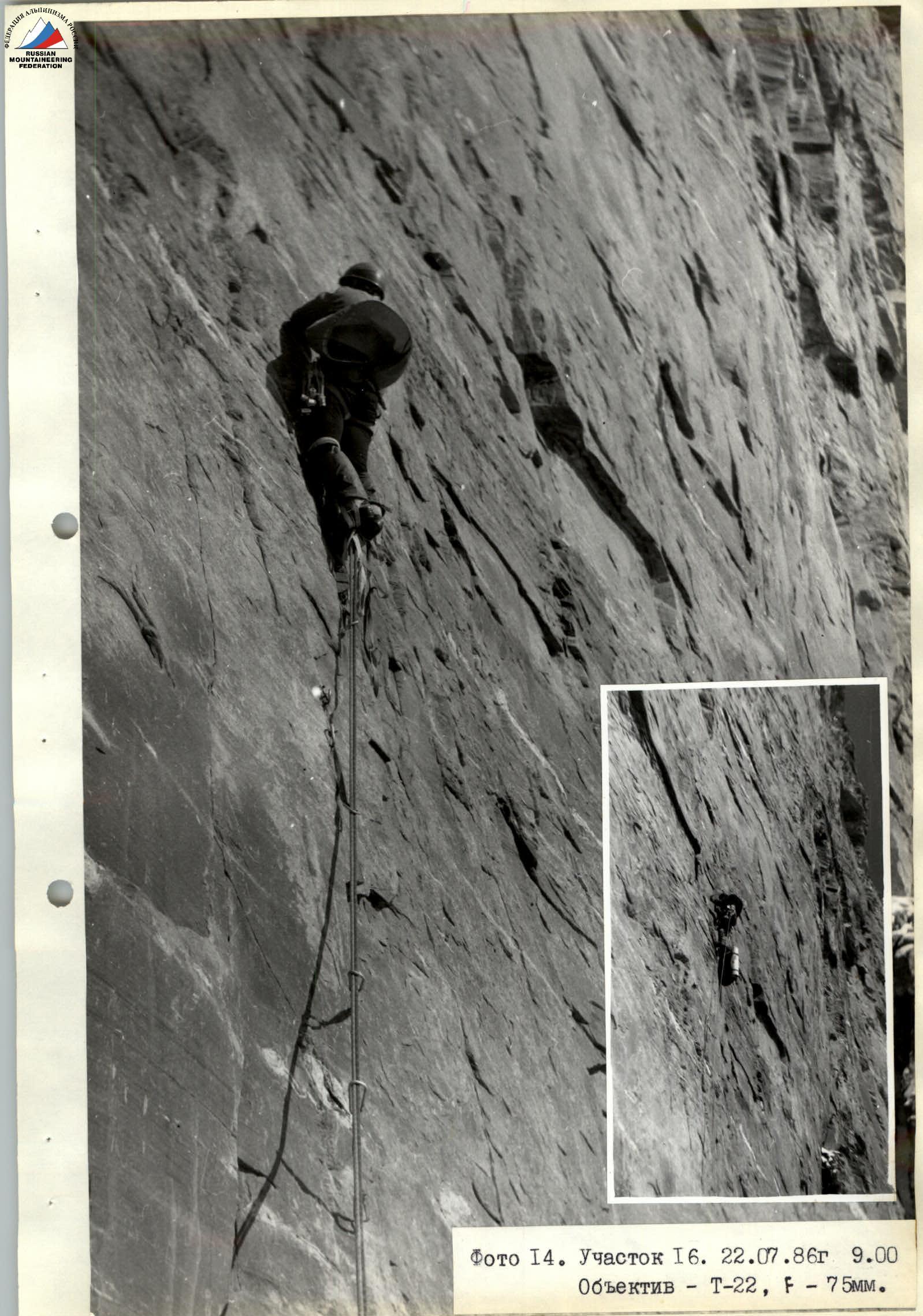

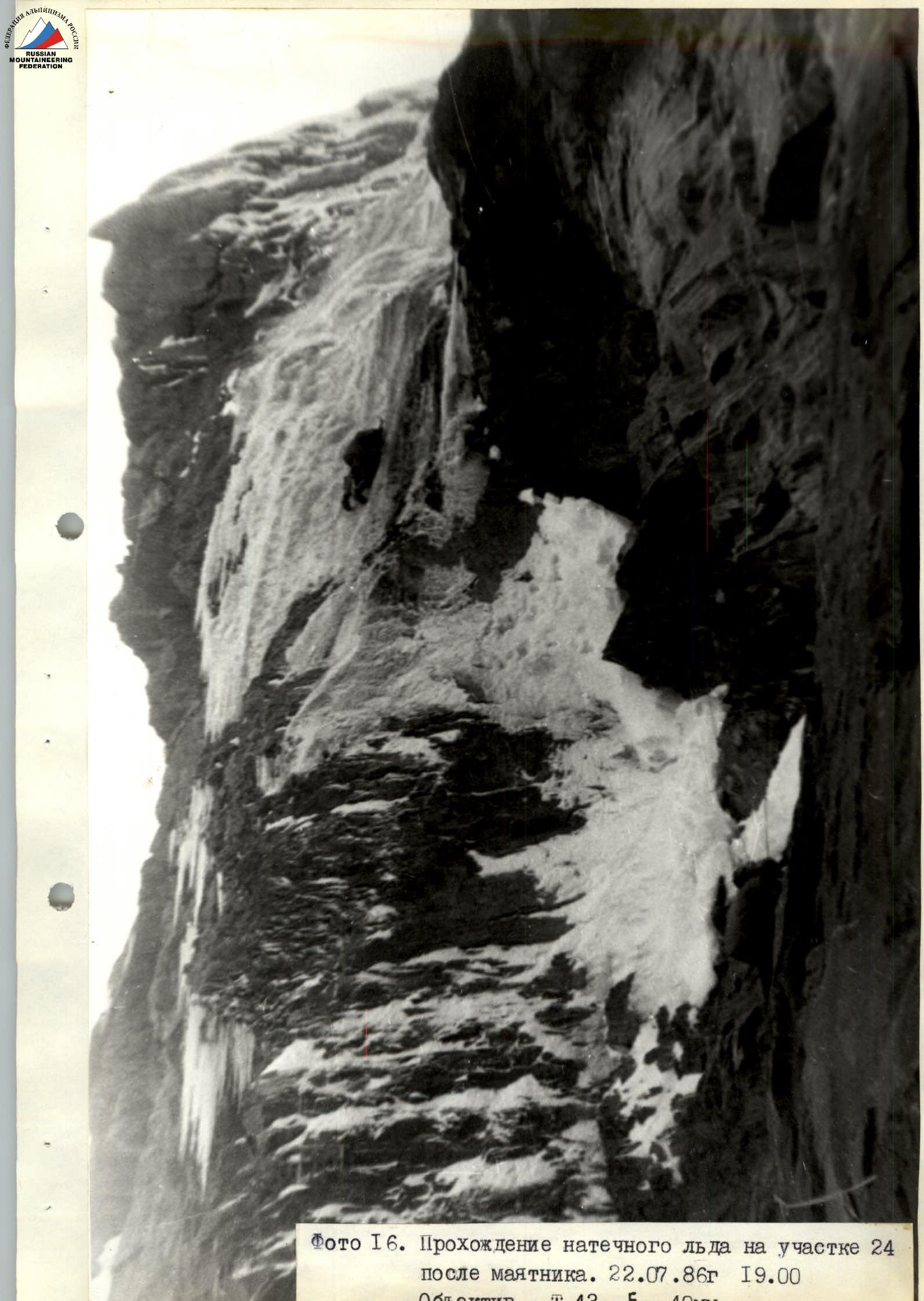
Photo 16. Passing rime ice on section R24 after the pendulum. July 22, 1986, 19:00. Lens — T-43, F — 40 mm.
Comments
Sign in to leave a comment