
Climbing Passport
-
Climbing type — High-altitude-technical.
-
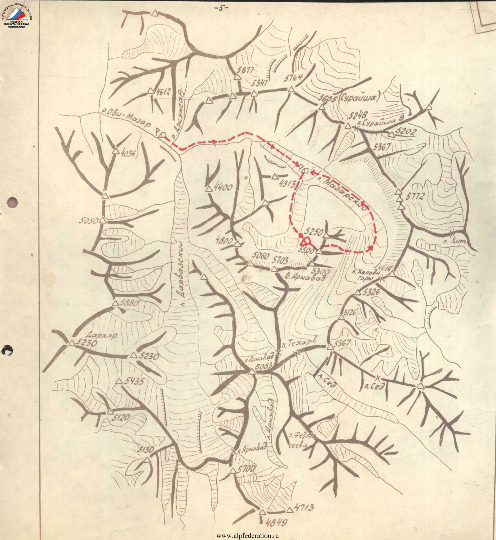
Climbing area — Western Pamir, spur of Darvaz Range.
-
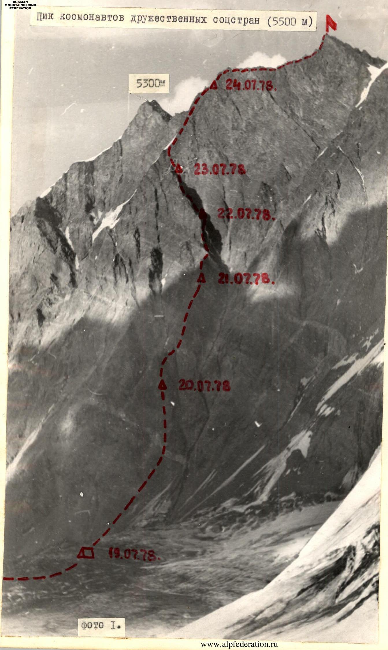
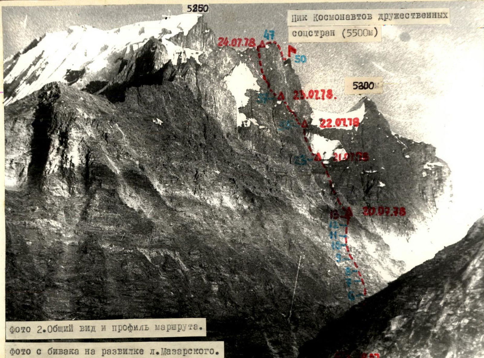
Peak, its height, climbing route — unnamed, 5500 m, via the middle buttress of the western wall.
-
Proposed difficulty category — 5B category of difficulty. First ascent.
-
Route characteristics:
height difference — 2000 m, length of sections with 5–6 category of difficulty — 990 m, average steepness to the ridge — 65°.
-
Number of driven pitons for belay and artificial climbing holds (ICH):
rock pitons — 155, including 22 for ICH, ice pitons — — , bolt pitons — —
-
Number of walking hours — 51.
-
Number of overnight stays and their characteristics — 5, including 2 semi-reclining.
-
Team leader — Kurshin Anatoly Petrovich (CMS),
team members — Penchuk Valentin Lavrentyevich (MS),
- Krivoruchenko Vladimir Stepanovich (1st sports category),
- Korolkov Boris Serafimovich (1st sports category),
- Boyko Valery Viktorovich (1st sports category),
- Vasiliev Sergey Nikolaevich (1st sports category).
-
Team coach — Penchuk Valentin Lavrentyevich.
-
Date of departure to the route — (from Mazirsky glacier) July 19, 1978.
-
Date of return — (to Mazirsky glacier) July 25, 1978. Peak of Cosmonauts of Friendly Socialist Countries (5500 m)
Brief geographical description and sports characteristics of the climbing route
The Western Pamir region, located in the upper reaches of the Obi-Mazar River, is poorly explored geographically and underdeveloped by climbers. In 1974, an expedition of climbers from the Leningrad Regional Council of the "Trud" Sports Society worked in this region, which climbed the most attractive peak in the Mazirsky-Arnavad East area and compiled a report on the results of their work.
Comparison of maps and materials available to the expedition of climbers from the MOS "Zenit" Sports Society, working in the Mazirsky glacier area, with the terrain revealed that:
- the relative positions of the peaks need to be уточнения;
- the heights of the peaks need to be уточнения;
- there is a clear lack of data on the climbing characteristics of the region.
Therefore, 4 groups of climbers from the expedition made reconnaissance and training ascents to various peaks in the Mazirsky and Darvaz Range spurs from the Mazirsky glacier to:
- determine possible climbing objectives and routes of approximately 5B category of difficulty;
- determine descent paths from the peaks;
- familiarize themselves with the region's climbing features, including:
- rock character;
- mountain life patterns;
- daily temperature fluctuations at high altitudes;
- water availability on southern and western slopes, etc.
During the reconnaissance, the team's attention was drawn to three peaks of similar height (~5500 m) located in the Darvaz Range spur near Arnavad East (see the map-scheme of the region).
To the west, the peaks drop off with sheer rock walls, approached by narrow buttresses. The buttresses resemble structures composed of stacked "towers" with steep walls.
The middle peak, the highest, was chosen by the team as the climbing objective via the middle buttress of the western wall. The route up to the pre-summit ridge was a pure rock climb. Small snow-ice sections were visible on the ridge.
Tactical climbing plan
As a result of the reconnaissance, a route was chosen that follows the bastions of the central buttress, leading to the left part of the western pre-summit sheer wall and then along the northwestern wall to the ridge, which leads to the summit.
The route along the buttress was considered the safest from rockfall. The presence of several short, gentler sections on the buttress suggested the possibility of suitable bivouac sites.
The team composition (6 people) allowed for reduced backpack weights and the ability to relieve the lead climber if needed. The team had 3 ropes and a 60 m rope, enabling them to process significant sections of the route above the bivouac and maintain the pace of the lead rope.
In addition to a set of 45 various rock pitons, the team had a kit of 10 bolt pitons.
It was anticipated that there might be issues with water on the route. Therefore, the team carried spare 3.5 l flasks for water storage.
Three possible descent options from the summit were considered:
- via the neighboring (northern) peak along its northwestern ridge;
- across the Arnavad plateau through the Tekharv pass to the Darvaz glacier;
- through the icefalls to the Mazirsky glacier.
The final descent option was to be determined after reaching the summit. To ensure a safe descent, the team carried the necessary number (8) of ice pitons and 2 pairs of crampons.
The total weight of food supplies was 4.8 kg per person before departing on the route. 4.0 l of gasoline were carried, ensuring good nutrition on the route for 6–7 days.
The planned climbing regime and tactical plan were largely executed.
Approach. July 18, 1978.
The team departed from the base camp near the confluence of the Mazirsky and Darvaz glacier valleys in the evening. They spent the night near the tongue of the Mazirsky glacier.
First day. July 19, 1978.
Approach to the camp on the Mazirsky glacier in the morning, observation of the wall. Final selection of equipment and supplies. Move to the moraine under the route. A pair of climbers clarifies the approach to the route walls.
Second day. July 20, 1978.
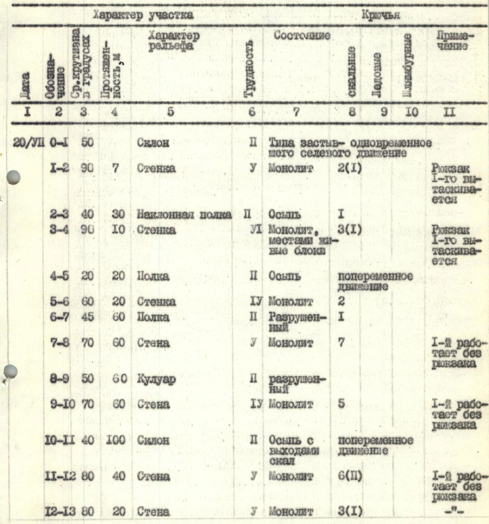
8:00 AM start on the route. Climb up a steep slope under the bastion walls, and immediately begin rock climbing:
- wall;
- move along an osypnaya polka under a new wall;
- overcome it, etc. (sections R1–R2 … R12–R13).
The walls and steep sections are quite complex. The first climber overcomes them mainly without a backpack.
His backpack is either pulled up (on short walls) or lifted using the hung ropes as handrails.
The route follows the bastion in a spiral-like manner:
- from right to left to the "neck" of the gully between the left and "our" buttresses;
- then upwards to the buttress ridge.
At 7:00 PM, a sufficiently wide, inclined osypnaya polka is found on the bastion wall above the "neck" level, where a tent platform is set up. A pair of climbers hangs ropes further, processing 150 m of the route. Water is obtained by climbing up to the gully-kuiluar with pre-hung handrails. Water is collected for the next day into flasks.
490 m of the route is covered during the day. 31 pitons are driven.
Third day. July 21, 1978.
7:00 AM ascent, 8:40 AM departure. Continue climbing the wall (section R13–R14) towards the buttress ridge, then:
- traverse the wall along the ridge (section R14–R15);
- further — along strongly destroyed rocks (section R15–R16) to the ridge, which (section R16–R17) is composed of crumbling sandstone.
The problem is driving pitons. Unpleasant maneuvering due to falling rocks.
Further:
- along ledges to the left of the ridge and along the wall (section R18–R19) — 100 m with a slight traverse left upwards — to the ridge.
Difficult maneuvering, местами very difficult. The first climber works without a backpack. Along the ridge, initially easy maneuvering, and then — 10 m vertical wall (section R20–R21) with an exit to a sharp ridge. Ladder racks are used.
Then along the ridge and ledges — to a place under a crumbling sentry, where a platform is made. A pair of climbers hangs a rope further along the route.
100 m before the platform, while moving towards it near the ridge, a dirty ice patch is found in a crevice, which is taken and used to prepare water in the evening and morning.
36 pitons are driven during the day, and 500 m of the route is covered.
Fourth day. July 22, 1978.
9:00 AM departure on the route. Along a ledge — bypassing the red sentry on the left (section R23–R24), along the wall (section R24–R25) with many "live" stones — to the ridge (section R25–R26), along which 55 m (partly difficult climbing) to a sentry with a clearly defined triangular end wall.
Further:
- traverse (~20 m) along narrow ledges of the sentry wall to the left leads to a steep gully (~40 m) with "live" stones in the upper part (section R27–R28);
- along the gully to a small shoulder. Climbing is difficult. The first climber works without a backpack.
Approach the key section of the day — an almost sheer 60 m wall (section R28–R29):
- the first climber goes in galoshes, without a backpack;
- his backpack is pulled up;
- ladder racks are used.
Exit to a sharp buttress ridge (section R29–R30), along which:
- 40 m with emotional climbing;
- then ~20 m along a ledge to the left of the ridge;
- approach a 20 m 80° wall.
The first climber overcomes it in galoshes without a backpack and exits back to the ridge.
Further:
- along a ledge (section R32–R33);
- gully (section R33–R34);
- slabs (section R34–R35);
- to the base of the next ascent, dubbed the "Camel": from below, from the sections of the second and third days, this and the subsequent ascent resemble camel humps.
A platform for a semi-reclining overnight stay is made. Water is obtained from snow preserved in a crevice.
31 pitons are driven during the day, and 460 m of the route is covered.
Fifth day. July 23, 1978.
9:00 AM departure on the route. Three hours are spent trying to bypass the tower along the walls on the left or right. The team concludes that it's necessary to climb the wall straight up (section R36–R37). Very difficult climbing. The first climber works in galoshes, ladder racks are used. All backpacks are pulled up in two stages: 50 m and 20 m. Around 5:00 PM, they reach the top of the tower. Continue processing the route further. At this time, several strong rockfalls pass along the route, reaching the tent platform on the tower's summit. It's decided to stop and set up for the night not on the platform but on a ledge at the tower's edge.
The overnight stay is semi-reclining. Water is obtained from snow preserved on the ledge.
20 pitons are driven during the day, and 160 m of the route is covered.
Sixth day. July 24, 1978.
6:00 AM departure on the route. The team decides to pass the rockfall-prone section along the northwestern wall as quickly as possible, as it's expected that the wall and upper part of the ridge will be exposed to sunlight from the west after 11:00 AM, increasing the risk of rockfall.
A simple ridge (section R37–R38) leads to the wall of the next ascent (section R38–R39), processed the previous day. Difficult climbing. Then a ridge and inclined ledge lead to a gully with many live stones, along which (difficult climbing, section R40–R41) they exit to the northwestern wall.
On the wall, several clearly visible stone columns are visible. Movement along the wall from right to left with a slight gain in height towards a protruding patch of snow-ice slope.
150 m of the route (sections R41–R42, R42–R43, R43–R44, R44–R45) with alternating movement from shelter to shelter, partly with medium climbing, and they exit to a gentler shoulder of the northwestern wall bastion, which slopes down. There's a chance to rest.
Further, the path along the wall (~300 m) to the ridge between the peaks (sections R45–R46, R46–R47) involves a slight traverse from right to left:
- ~150 m — independent movement by the rope team along pitons driven by the 1st team;
- 100 m — movement along handrails (sections with difficult climbing);
- 50 m — traverse of the wall along inclined ledges.
At 12:00 PM, the last team reaches the ridge. They rest until 1:00 PM. Then, without backpacks (planning to start descending from the ridge into the ice-rock cirque), they head towards the summit along the ridge.
The ridge is simple (3–4 category of difficulty). Alternating or simultaneous movement with belay through bends and protrusions. 2 pitons are driven in 2 places. The ascent to the summit is along a wall (section R48–R49). Initially, 60 m of very difficult climbing.
- At 6:00 PM — on the summit.
- Descent from the summit: 20 m climbing, then 60 m rope descent.
- Return to backpacks at 9:00 PM. A tent platform is set up here.
Seventh day. July 25, 1978.
9:30 AM start descending from the ridge into the ice-snow cirque between the ridges of the peaks. The descent path was planned the previous day. The upper part of the path was visible from the ridge, and the lower part was previously scouted. From the cirque, the path leads towards the Mazirsky glacier. The descent from the ridge along rocks to the snow — 150 m, sporting. Then along the snow — exit to the powerful crevasses of the icefall, which is traversed along the center, and then to the right between seracs — path to the snow slopes of the right ridge, along which — down to the base of the icefall, and then along ice-snow slopes — to the Mazirsky glacier.
2 ice pitons are driven during the descent.
The team reaches the glacier at 3:30 PM and arrives at the camp on the glacier at 6:00 PM. The ascent is complete.
No summit register, note, or other signs of human presence were found on the summit, confirming the team's assumption of a first ascent.
By right of first ascenders, the team unanimously proposes to name the peak "PEAK OF COSMONAUTS OF FRIENDLY SOCIALIST COUNTRIES" in honor of the first joint flight of cosmonauts from the USSR and Czechoslovakia.
Table of main characteristics of the climbing route
Departure time on the route — 8:00 AM. Time of stopping at the bivouac — 7:00 PM. Number of walking hours — 11. A pair of climbers processed another 150 m of the route. The platform is laid out on a ledge.
| Date | Section | Steepness, ° | Length, m | Relief | Difficulty | Condition | Rock Pitons | Ice Pitons | Bolt Pitons | Notes |
|---|---|---|---|---|---|---|---|---|---|---|
| 20/III | R0–R1 | 50 | Slope | 2 | Like a frozen mudflow | Simultaneous movement | ||||
| R1–R2 | 90 | 7 | Wall | У | Monolith | 2(1) | 1st climber's backpack is pulled up | |||
| R2–R3 | 40 | 30 | Inclined ledge | 2 | Scree | 1 | ||||
| R3–R4 | 90 | 10 | Wall | У1 | Monolith, partly with live blocks | 3(1) | 1st climber's backpack is pulled up | |||
| R4–R5 | 20 | 20 | Ledge | 2 | Scree | Alternating movement | ||||
| R5–R6 | 60 | 20 | Wall | 1У | Monolith | 2 | ||||
| R6–R7 | 45 | 60 | Ledge | 2 | Destroyed | 1 | ||||
| R7–R8 | 70 | 60 | Wall | У | Monolith | 7 | 1st climber works without a backpack | |||
| R8–R9 | 50 | 60 | Gully | 2 | Destroyed | |||||
| R9–R10 | 70 | 60 | Wall | 1У | Monolith | 5 | 1st climber works without a backpack | |||
| R10–R11 | 40 | 100 | Slope | 2 | Scree with rock outcrops | Alternating movement | ||||
| R11–R12 | 80 | 40 | Wall | У | Monolith | 6(2) | 1st climber works without a backpack | |||
| R12–R13 | 80 | 20 | Wall | У | Monolith | 3(1) |
Departure time on the route — 8:40 AM. Time of stopping at the bivouac — 7:00 PM. Number of walking hours — 10. A pair of climbers hung ropes further along the route. The tent platform is made on the ridge.
| Date | Section | Steepness, ° | Length, m | Relief | Difficulty | Condition | Rock Pitons | Ice Pitons | Bolt Pitons | Notes |
|---|---|---|---|---|---|---|---|---|---|---|
| 21/III | R13–R14 | 60 | 70 | Wall | У | Monolith, with live stones | 6 | |||
| R14–R15 | 60 | 60 | Wall, traverse at 20° | 1У | "-" | 4 | ||||
| R15–R16 | 60 | 100 | Wall | У — | Strongly destroyed | 4 | 1st climber works without a backpack, difficulties with piton placement | |||
| R16–R17 | 60 | 60 | Ridge | У | Composed of crumbling sandstone | 6(1) | ||||
| R17–R18 | 20 | 20 | Ledge | 1У | Destroyed | Alternating movement | ||||
| R18–R19 | 85 | 100 | Wall | У | Monolith | 8(2) | 1st climber works without a backpack | |||
| R19–R20 | 40 | 20 | Ridge | 1У | Monolith | Alternating movement | ||||
| R20–R21 | 90 | 10 | Steep wall with exit to a sharp ridge | У1 | "-" | 4(2) | 1st climber works without a backpack, ladder racks used | |||
| R21–R22 | 20 | 50 | Sharp ridge | 1У | Monolith, partly destroyed | 2 | ||||
| R22–R23 | 70 | 15 | Wall | У | Monolith | 2 |
Departure time on the route — 9:00 AM. Time of stopping at the bivouac — 8:30 PM. Number of walking hours — 11. Overnight stay on a ledge, semi-reclining.
| Date | Section | Steepness, ° | Length, m | Relief | Difficulty | Condition | Rock Pitons | Ice Pitons | Bolt Pitons | Notes |
|---|---|---|---|---|---|---|---|---|---|---|
| 22/III | R23–R24 | 20 | 50 | Ledge | 2 | Destroyed | Alternating movement | |||
| R24–R25 | 60 | 20 | Wall | 1У | "-" | 3 | ||||
| R25–R26 | 50 | 55 | Ridge with a 5 m wall | У | "-" | 3 | ||||
| R26–R27 | 20 | 80 | Wall, traverse at 20° | У | 2 | |||||
| R27–R28 | 75 | 40 | Gully | У | With live stones in the upper part | 5(2) | 1st climber without a backpack | |||
| R28–R29 | 85 | 60 | Wall | У — | Monolith | 9(1) | 1st climber in galoshes, without a backpack, ladder racks used | |||
| R29–R30 | 20 | 40 | Sharp ridge | 2 | "-" | Alternating movement, emotional climbing | ||||
| R30–R31 | 20 | 20 | Ledge | 2 | Destroyed | "-" | ||||
| R31–R32 | 80 | 20 | Wall | У | Monolith | 3(1) | 1st climber without a backpack | |||
| R32–R33 | 40 | 20 | Inclined ledge | 2 | Destroyed | 1 | ||||
| R33–R34 | 60 | 20 | Gully | 1У | Partly with live blocks | 2 | ||||
| R34–R35 | 40 | 40 | Slabs | 1У | Monolith | 3 |
Departure time on the route — 9:00 AM. Time of stopping at the bivouac — 6:00 PM. Number of walking hours — 9. Overnight stay semi-reclining. 80 m of the route processed.
| Date | Section | Steepness, ° | Length, m | Relief | Difficulty | Condition | Rock Pitons | Ice Pitons | Bolt Pitons | Notes |
|---|---|---|---|---|---|---|---|---|---|---|
| 23/III | R35–R36 | 50 | 80 | Inclined ledges, slabs | 1У | Destroyed | 3 | |||
| R36–R37 | 85 | 80 | Wall | У1 | Monolith | 17(7) | 1st climber in galoshes. Ladder racks used. Backpacks pulled up |
Departure time on the route — 6:00 AM. Time of stopping at the bivouac — 9:00 PM. Number of walking hours — 13. Tent platform made on the ridge. Descent from the summit to the bivouac on the ridge — along the ascent path.
July 25 — Descent from the ridge to the ice-snow cirque and through the icefall to the Mazirsky glacier took 6 hours. The ascent was made in stable, good weather.
| Date | Section | Steepness, ° | Length, m | Relief | Difficulty | Condition | Rock Pitons | Ice Pitons | Bolt Pitons | Notes |
|---|---|---|---|---|---|---|---|---|---|---|
| 24/III | R37–R38 | 10 | 20 | Ridge | 2 | Destroyed | Simultaneous movement | |||
| R38–R39 | 70 | 60 | Wall | У | Monolith | 5(1) | 1st climber without a backpack, in galoshes | |||
| R39–R40 | 10 | 40 | Ridge and inclined ledge | 2 | Destroyed | Alternating movement | ||||
| R40–R41 | 75 | 20 | Gully | У | Destroyed, rockfall-prone | 3 | ||||
| R41–R42 | 60 | 10 | Wall | 1У | Monolith, rockfall-prone | 2 | ||||
| R42–R43 | 60 | 50 | Wide gully, traverse at 20° | 1У | "-" | 2 | ||||
| R43–R44 | 60 | 10 | Wall | 1У | Monolith, rockfall-prone | 1 | ||||
| R44–R45 | 60 | 80 | Wall, traverse at 40° | 1У | "-" | 1 | ||||
| R45–R46 | 60 | 250 | Wall | 1У | Monolith, rockfalls, partly iced | 13 | ||||
| R46–R47 | 60 | 50 | Wall, traverse at 30° | 1У | Destroyed | 1 | ||||
| R47–R48 | 50 | 700 | Ridge, partly snow-ice | 2 | Alternating or simultaneous movement | 2 + protrusions | ||||
| R48–R49 | 85 | 60 | Wall | У | Monolith | 5 | ||||
| R49–R50 | 60 | 30 | Wall | 1У | "-" | 2 |
General characteristics of the route and recommendations for its passage
The route is a rock climb of considerable length (~2200 m without the ridge section) and consists of a large number of technically complex sections (the length of sections with 5–6 category of difficulty is ~990 m). The route is logical. The optimal rope length for the group is 60 m. When preparing for the ascent, the following should be considered:
- The absence of good rock climbers in the group can significantly increase the time required to complete the route.
- A safe descent from rockfall is only possible via the ascent route.
- The upper part of the route, passing along the northwestern wall, may be subject to strong rockfalls. This section should be passed early in the morning, as the ridge from which rockfalls originate is exposed to sunlight from the west after 10:00 AM.
- Water is largely absent on most of the route in late summer.
For the descent from the summit, the path taken by the group can be recommended. However, one should be cautious of rockfalls (when bypassing ice discharges to the right) from the slopes of the eastern ridge of the summit.
Kurshin A.P., Penchuk V.L., Krivoruchenko V.S., Korolkov B.S., Boyko V.V., Vasiliev S.N.
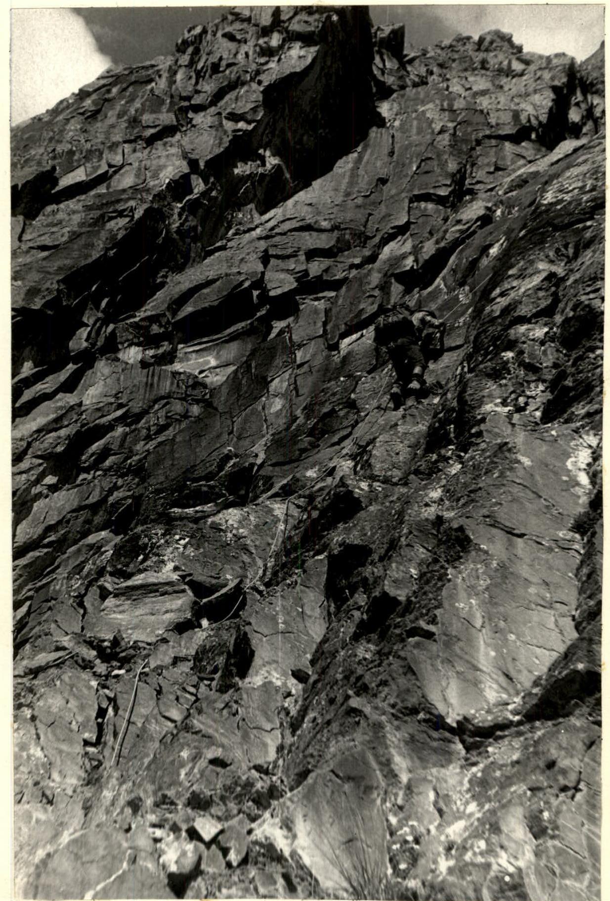
Photo 6. On section R13–R14.
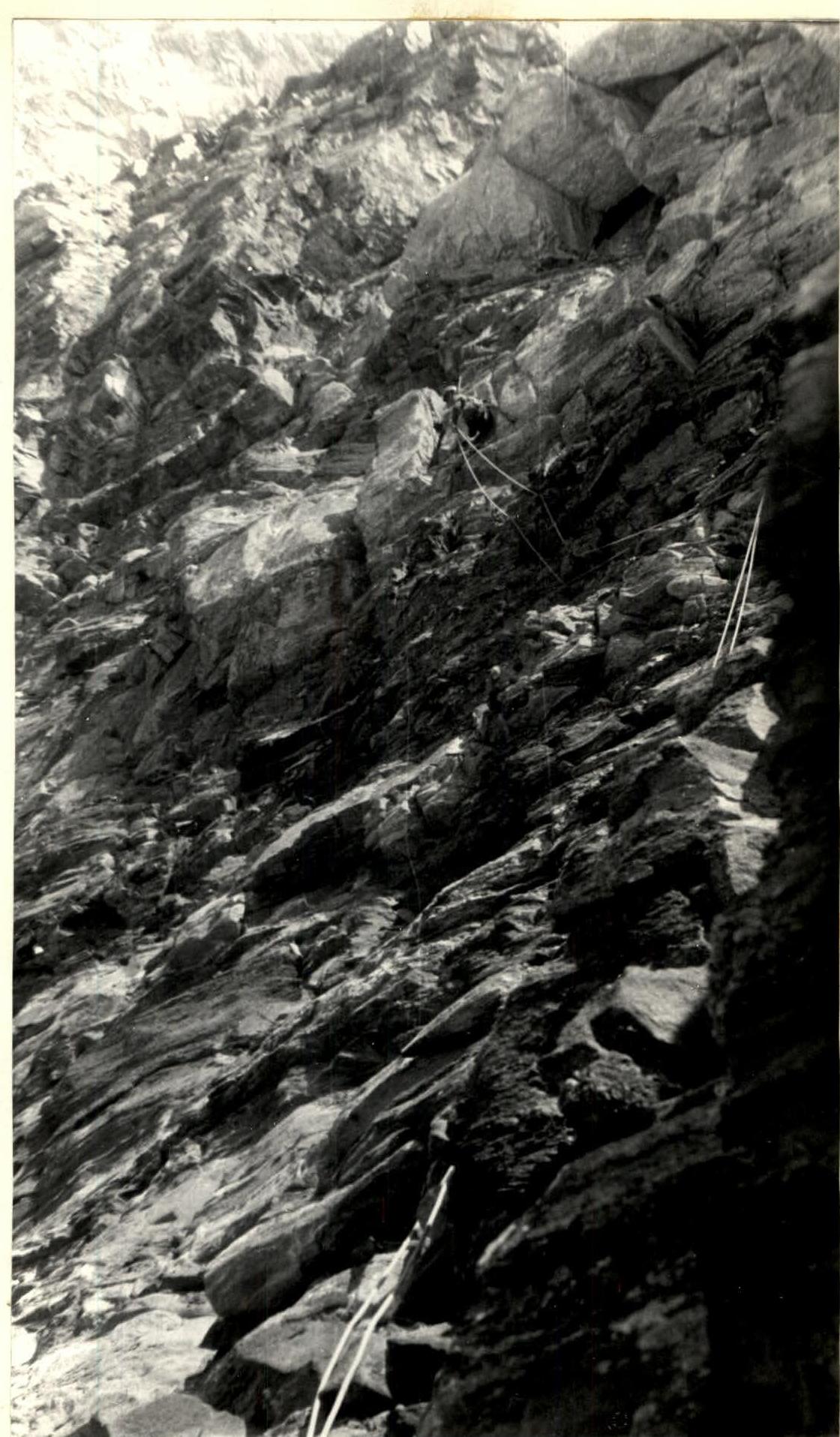
Photo 8. On section R18–R19.

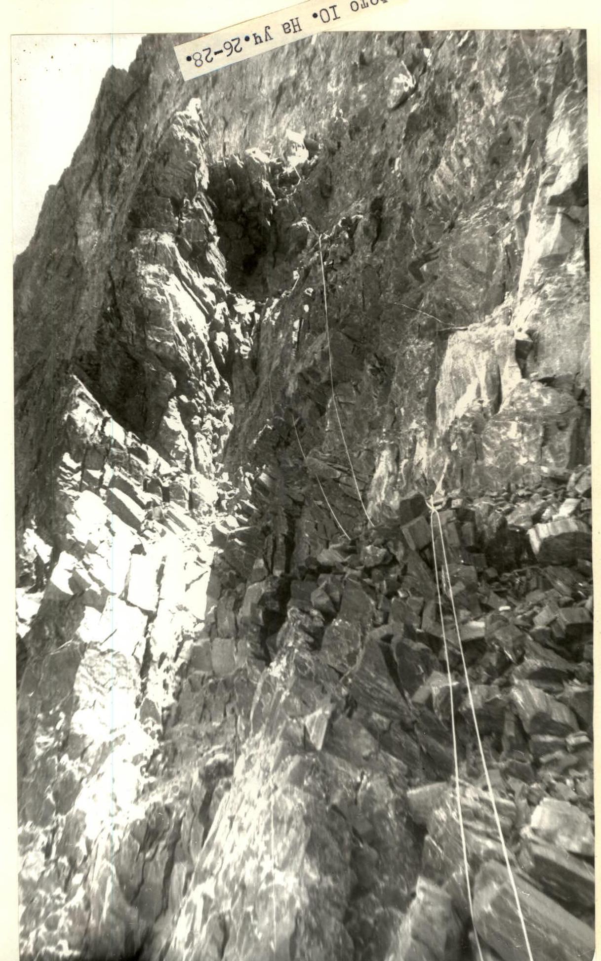
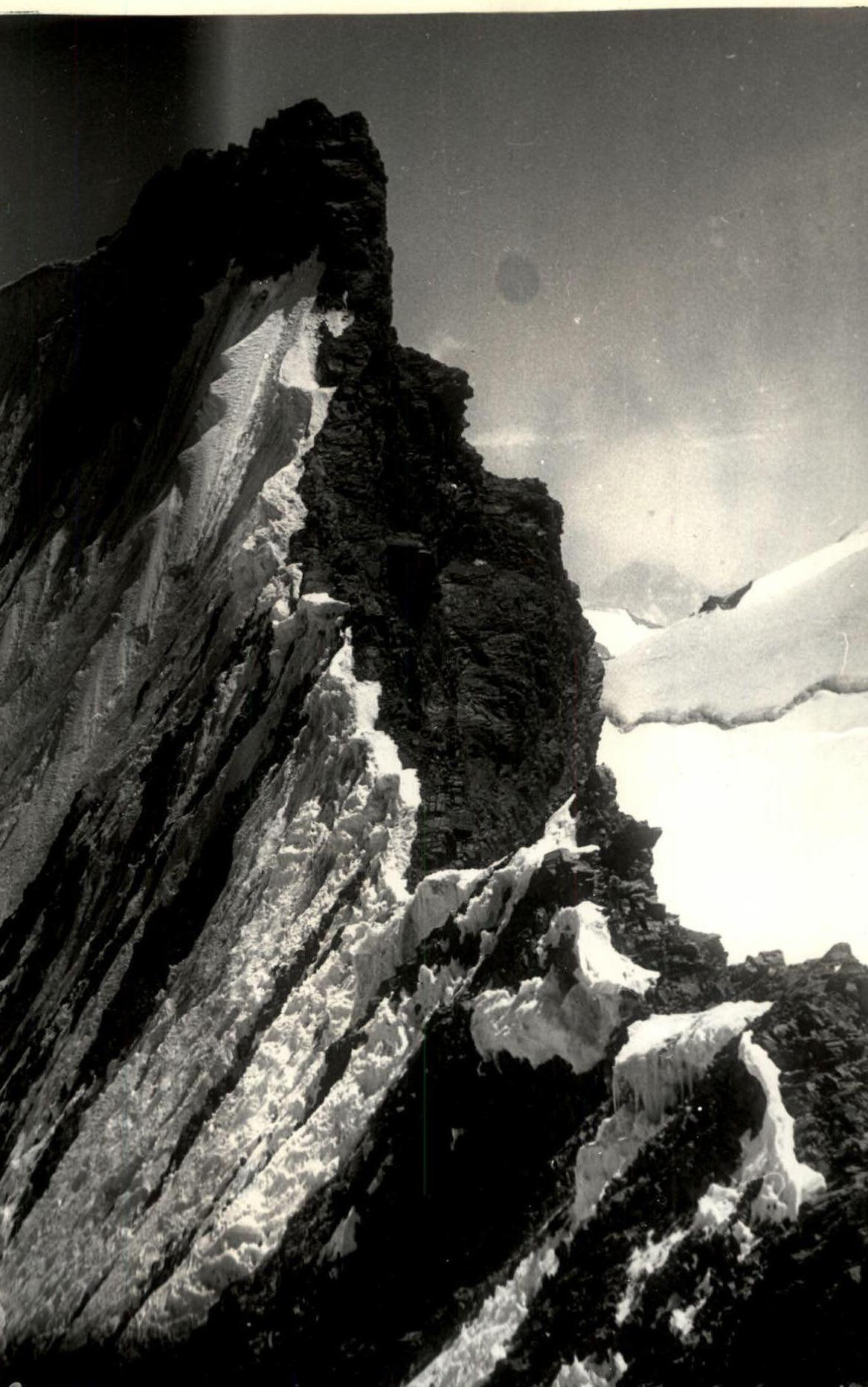
Photo 15. On section R47–R49.
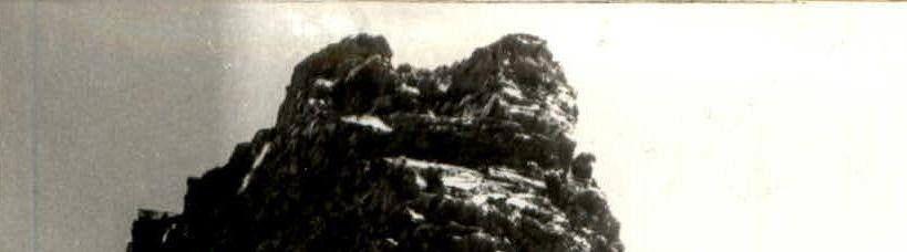
Photo 16. On section R48–R49.
