Ascent Passport
- Ascent class: technical
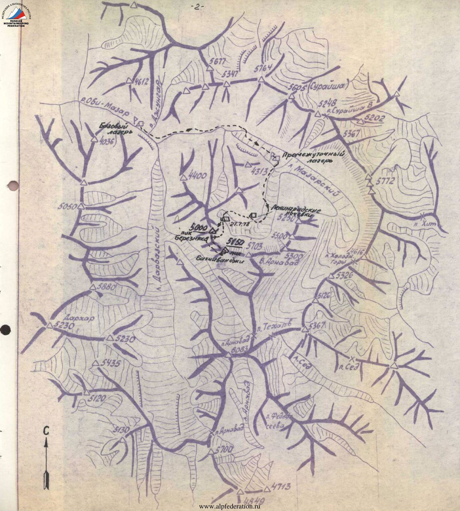
- Ascent area, ridge: Western Pamir, Darvaz ridge, Mazarsaya valley
- Peak, its height, ascent route: traverse of peaks Bereznyak (5000) and Bakhchivandzhi (5150) with ascent to peak Bereznyak via the eastern buttress
- Proposed difficulty category: 5B
- Route characteristics:
height difference 1200 length of sections with 5–6 cat. diff. — 1040 m. total route length to peak Bakhchivandzhi 3500 m
- Pitons driven:
| FOR BELAY | FOR CREATING I.T.O. | TOTAL | |
|---|---|---|---|
| Rock | 135 | 25 | 160 |
| Ice | 22 | 8 | 30 |
| Bolt | 16 | 16 | |
| Total: | 157 | 49 |
-
Number of climbing hours: 50.5 h
-
Number and characteristics of bivouacs: 27.07 4100 m, on moraine of glacier, normal, water available, prep time 1 h 30 min 28.07 4700 m, on ledge, normal, water available, prep time 40 min 29.07. 4850 m, on col, normal, snow 20 m away, prep time 1 h 30 min 30.07 5060 m, on col, normal, water available, prep time 1 h 10 min
-
Group leader: — Kuzmin Anatoly Sergeevich CMS — Ivanchin Ivan Andreevich CMS — Makhnovich Leonid Alexandrovich CMS — ROMANOV Alexander Alexandrov */ — Penchuk V.L. master of sports of the USSR
-
Team coach:
-
Date of departure to the route: July 27, 1978 return: July 31, 1978
www.alpfederation.ru↗ Arnavad and Suraysha and some other training 1–2 routes, which were not classified and even the climbers themselves could not pinpoint the location of these mountains. The second of the lateral valleys leads to the Arnavad pass. The Arnavad glacier, lying in the valley, gives rise to a full-flowing southern tributary of the river Obilazar.
Just below the confluence of these two valleys, in a shaded poplar-birch grove, the base camp was set up. Just above the base camp, in the Mazarsaya ridge, a beautiful peak was visible (somewhat reminiscent of peak Engels), which we later named the Peak of Soviet Olympians. 10 km downstream, a large tributary flows in from the left from the Darharvag valley. Halfway between Darharvag and our base camp, on the very edge of a high and gradually crumbling cliff, stands a mausoleum with the sarcophagus of Khazrati Burkh (Saint Burkh) — a place of pilgrimage for Muslims. Every other day, up to 50 or more pilgrims would come here, so the trail is well-trodden, but it was still difficult for the donkeys, and in many places it had to be literally cut out to ensure the passage of the donkeys with cargo. The journey uphill took 7 days. We had to shuttle with all participants of the gathering, as the number of donkeys was limited; this took a lot of effort and time, but at the same time, all participants acclimatized well.
A suspended ropeway was set up across one of the tributaries flowing into Obilazar from the Mazarsaya ridge, and the entire cargo and participants were ferried across this ropeway, while the donkeys were led across with great difficulty, empty, beyond the aerial crossing.
The return journey with the donkeys took about 4 days + 2 days by bus on a fairly decent road (previously, buses did not run there, so the driver was reluctant to drive). After 70 km of difficult road, the bus arrived in Tavil-Dara, and then it was already possible to quickly reach Dushanbe on asphalt. The delivery to the site and evacuation took just under 2 weeks, and this method of transportation can hardly be recommended for subsequent expeditions to this area. There are still many unclimbed peaks and unexplored cirques in the area of the expedition (e.g., Darharvag, cirque of the Arnavad glacier). But in the upper reaches of the Mazarsaya glacier, most of the main peaks and the most interesting routes — 5B category of difficulty — were climbed by participants of our gathering (5 routes 5B, 4 training routes from 3B to 5A category of difficulty).
 4713
4713
Brief description of the approach to the route
From the base camp, the path goes upstream along the left side of the valley to the Mazarsaya glacier (~ 4 h), then along the center of the glacier to a lateral valley leading south to the Arnavad massif, in one ridge with which, to the west, stand peaks 5150 (Bakhchivandzhi) and peak 5000 (peak Bereznyak), closing the valley.
To ascend into this cirque, one must first go through a gap formed by the slopes of the mountains and the right (along the way) sharp moraine, about an hour, then cross the moraine and move to the glacier, moving along its edge, and then along the center towards the rusty semi-circular moraine for about another hour; ascent along the moraine — and in 40 min we arrive at the Leningradskie bivouac (named by the expedition of the Leningrad "Trud").
From here, an ascent along grassy slopes along a chain of small lakes located on stepped terraces along the walls of peak Arnavad and peak Bakhchivandzhi, with a small gain in height, leads to peak Bereznyak.
Crossing a chain of low moraines, we exit onto the glacier. It takes about half an hour to walk to the start of the route along the glacier. Height 3900 m according to the altimeter. Overnight stay on a small moraine of the glacier near a small lake. This place is called "Podmoskovnye bivouac" by the group.
ROUTE CHARACTERISTICS TABLE
| Date | Designation | Avg. steepness in deg. | Length in m | Relief character | Difficulty | Condition | Weather conditions | Rock | Ice | Bolt |
|---|---|---|---|---|---|---|---|---|---|---|
| I | 2 | 3 | 4 | 5 | 6 | 7 | 8 | 9 | 10 | 11 |
| 28.7 | R1 | 30 | 200 | snow-ice slope | 2 | normal | good | - | - | - |
| R2 | 80 | 3 | Bergschrund | 5B | - | -"- | - | 1У | - | |
| R3 | 45 | 55 | ice slope | 4 | monolithic | -"- | - | 4 | - | |
| R4 | 50 | 40 | rocks | 4 | destroyed | -"- | 2 | - | - | |
| R5 | 80 | 50 | wall | 5B | destroyed | -"- | 8, P | - | - | |
| R6 | 80 | 50 | wall | 5B | -"- | -"- | 6 | - | - | |
| R7 | 60 | 30 | slab | 5B | glazed | -"- | 3, P | 1 | -II | |
| R8 | 45 | 120 | ledge, traverse | 4 | destroyed | -"- | 6 | |||
| R9 | 60 | 80 | buttress | 5B | destroyed | -"- | 5, cam | 1 | - | |
| R10 | 15 | 25 | inclined ledge | 3 | - | -"- | 1, cam | - | - | |
| R11 | 70 | 140 | wall | 5B | very weak rocks | -"- | 12, P | 2, P | - | |
| R12 | 20 | 20 | traverse wall to snow | 3 | destroyed | -"- | cam | - | - | |
| R13 | 45 | 45 | buttress | 3Б | destroyed | -"- | 1, cam | - | - | |
| Departure time | 6:05 | |||||||||
| Arrival at bivouac | 18:00 | |||||||||
| Climbing hours | 12 | |||||||||
| Bivouac normal | ||||||||||
| I | 2 | 3 | 4 | 5 | 6 | 7 | 8 | 9 | 10 | 11 |
| 29.7 | R14 | 50 | 30 | buttress | 4 | destroyed | good | 2 | 1 | - |
| R15 | 65 | 25 | wall | 5А | monolithic | -"- | 7, P | - | - | |
| R16 | 65 | 30 | buttress | 5А | destroyed | -"- | 1, cam | - | - | |
| R17 | 35 | 40 | buttress | 3 | destroyed | -"- | - | - | - | |
| R18 | 45 | 160 | buttress | 4 | destroyed | -"- | 4, cam | 1 | - | |
| R19 | 30 | 70 | rocks, traverse to main ridge | 3 | destroyed | -"- | 1, cam | - | - | |
| R20 | 45 | 200 | rock ridge | 4 | destroyed | -"- | 5, cam | |||
| R21 | 70 | 20 | rock wall | 5B | monolithic | -"- | 2, P | - | - | |
| R22 | 0 | 120 | ridge | 1 | destroyed | -"- | simultaneous movement | - | - | |
| R23 | 40 | 500 | ridge | 3 | destroyed | good | -"- | - | ||
| R24 | 0 | 30 | col | destroyed | -"- | cam |
Departure time 6:20. Arrival at bivouac 21:05. Climbing hours 15. Bivouac normal in a tent on a rock ledge (preparation time 1 h 30 min.)
| I | 2 | 3 | 4 | 5 | 6 | 7 | 8 | 9 | 10 | 11 |
|---|---|---|---|---|---|---|---|---|---|---|
| 30.7 | R25 | 30 | 46 | ridge | 3 | destroyed | good | cam | - | - |
| R26 | 60 | 100 | ridge | 5А | destroyed | -"- | 8, cam | - | - | |
| R27 | 80 | 6 | pinnacle | 6 | monolithic | -"- | 3 | - | - | |
| R28 | 70 | 3 | col | 5А | monolithic | -"- | - | - | - | |
| R29 | 90 | 15 | wall | 6 | monolithic | -"- | 2 | X | - | |
| R30 | 85 | 20 | -"- | 6 | glazed | -"- | 7 | 1 | 1V | |
| R31 | 75 | 10 | -"- | 5Б | -"- | -"- | 4 | |||
| R32 | 46 | 40 | ridge | 5А | -"- | -"- | 4 | - | - | |
| R33 | 30 | 20 | ridge | 4 | -"- | -"- | - | - | - | |
| R33А | 0 | 80 | 3 | -"- | -"- | simultaneous | ||||
| R34 | 70 | 30 | 1 pinnacle | 5Б | heavily destroyed | -"- | 2, cam | - | - | |
| R35 | -30 | 80 | ridge | 3 | destroyed | -"- | simultaneous | - | - | |
| R36 | 70 | 40 | 2nd pinnacle | 5Б | destroyed | -"- | 2 | |||
| R37 | -15 | 30 | ridge | 3 | -"- | -"- | cam | - | - | |
| R38 | 65 | 70 | 3rd pinnacle | 5А | -"- | -"- | 4, cam | - | - | |
| R40 | 0 | 40 | ridge | 2 | -"- | -"- | simultaneous | - | - | |
| R41 | -40 | 15 | drop | 4 | -"- | -"- | sport climb through cam | - | - | |
| R42 | 40 | 30 | ridge | 4 | destroyed | -"- | 1, cam | - | - | |
| 1 | 2 | 3 | 4 | 5 | 6 | 7 | 8 | 9 | 10 | 11 |
| R43 | 10 | 120 | wide ridge | 2 | destroyed | good | simultaneous | - | - | |
| R44 | 80 | 50 | 5th pinnacle | 6 | layered rocks | -"- | 6, ladders | 1 | - | |
| R45 | steep ascents 70–80 | 300 | ridge of 4 pinnacles | 3Б | destroyed | -"- | 4 | - | - | |
| R46 | 70 | 40 | tower of false summit | 6 | layered rocks | -"- | 4, III | 2 | - | |
| R47 | 40 | 60 | ice | 4Б | dense | -"- | 4 | |||
| R48 | 15 | 80 | traverse 70° wall | 5Б | ledges | -"- | 2 | 2 | - | |
| R49 | 80 | 20 | wall | 5Б | destroyed | -"- | 3, cam | |||
| R50 | 5 | 20 | ledge | 5А | -"- | -"- | 2 | - | - | |
| R51 | -25 | 60 | ridge | 2 | destroyed | -"- | simultaneous | - | - |
Departure time 8:00. Arrival at bivouac 21:30. Climbing hours 13.5. Bivouac on col, normal
| I | 2 | 3 | 4 | 5 | 6 | 7 | 8 | 9 | 10 | 11 |
|---|---|---|---|---|---|---|---|---|---|---|
| 31.7 | R52 | 30 | 40 | ridge | 3 | destroyed | -"- | cam | - | - |
| R53 | 50 | 40 | ridge | 4 | -"- | -"- | 3, cam | - | - | |
| R54 | -15 | 30 | ridge | 2 | -"- | -"- | cam | |||
| R55 | 30 | 30 | 3 | -"- | -"- | 3 | - | - | ||
| R56 | -20 | 15 | descent to col | 2 | -"- | -"- | - | - | - | |
| R57 | 70 | 5 | pinnacle | 5А | monolithic | -"- | 2, P | - | - | |
| R58 | -50 | 40 | ridge | 4 | destroyed | -"- | 1, cam | - | - | |
| R59 | 80 | 40 | wall | 6 | layered unstable rocks | -"- | 8, P | - | - | |
| R60 | 70 | 20 | wall | 5 | strong rocks | -"- | 2 | - | - | |
| R61 | -90 | 100 | wall | |||||||
| R62 | -80 | 240 | couloir | |||||||
| R63 | -30 | 300 | slopes | |||||||
| R64 | -20 | 500 | sheep's backs | |||||||
| R65 | 30 | 600 | ascent to col |
Departure time 8:30. Arrival at bivouac 21:00. Climbing hours 11.6 t.h. for ascent 54. Bivouac normal.
Route passage
(brief explanation of the table of sections)
1st day July 27, 1978
Departure from base camp at 7:00. We reach the Leningradskie bivouac at 14:00, and an hour later — to the place where the high-altitude tent is set up. From here to the start of the route is 40 min along the center of the glacier. Rest, and at 16:00 the duo Makhnovich—Ivanchin sets out to process the wall, taking iron and ropes with them. The duo returns at 21:00 — 2 ropes are hung: on ice to the rocks and on a difficult section of the wall.
2nd day July 28, 1978
We depart at 6:05. We follow the glacier along yesterday's tracks. We pass a 200-meter snow-ice slope. We climb the ice wall using screw pitons and ladders. We pull up backpacks. We climb a steep ice slope along a hung rope and reach the complex part of the route. The rocks, despite their great steepness, are heavily destroyed. This creates additional difficulties in terms of both passing the route, organizing belay, and safety of the entire group. We pass the processed section and gather on a small ledge. The Ivanchin—Makhnovich team moves forward and passes another rope to an inclined 30-meter slab. And here we encounter the same difficulties in this area: the rock crumbles, there are few places to drive pitons. We pass the slab using 3 ladders. We pull up backpacks. The path then goes along a 45° inclined ledge up to the right to a clearly defined buttress in the middle of the wall. The buttress ridge leads to a 120-meter wall. We traverse along a small ledge to the left for 25 m, a short rest. Then the Kuzmin—Romanov team moves forward. The second team follows the hung ropes. The wall ends with a small buttress, to the right is a large snowpatch. We reach the planned bivouac site. We prepare a site at the upper part of the snow at 18:00. Everyone is tired but satisfied — we have passed the key section of the route to the 1st peak. Tomorrow we will be on the summit.
3rd day July 29, 1978
The first team departs at 6:20. The sun is already shining on the wall. The night was warm. We pass a buttress about 1 rope length to a monolithic wall. Difficult climbing, Makhnovich climbs it in galoshes, hangs 2 ladders, backpacks have to be pulled up because the available holds are completely unreliable. Then the route gradually becomes more gentle. We move along a heavily destroyed ridge, first to the right for 30 m, then 40 m to the left, then up to the right to a gap forming an internal angle in the upper part. From it, a traverse to the right onto the ridge along heavily destroyed rocks. Belay is mostly through cams and rock fins. The path to the summit is no longer difficult, the teams move simultaneously. A small but complex wall blocks the ascent to the summit. At 12:20 we are on the summit, and by right of first ascenders, we propose to name it after aircraft designer Alexander Yakovlevich Bereznyak. The summit and ridge to the col are heavily destroyed and present no difficulties. We photograph the further path. From the summit, it is visible that taking the steep ascent of the marble belt will be difficult. We decide to bivouac on the col. We prepare a site on the western side of the tooth. The Romanov—Kuzmin duo, taking spare pitons and all ropes, sets out to process the ascent to the marble belt. We bypass the tooth on the col and ascend along black rocks, first not very steep, and then steeper, to the beginning of the white ridge. The rock is clearly stronger, although it crumbles to sand in some places. Difficult climbing. Belay through cams. In two places, we have to pull up backpacks for 8–10 m. We approach the key section of the route. The upper part of the marble belt on the north drops off with a sheer wall, on the south and west — glazed windward slopes, reminiscent of the "Sugarloaf". The ridge abuts it, ending with a small thin col after a 6-meter pinnacle. There are no cracks for pitons at all; promising large cracks turn out to be completely unreliable: these are delaminations, which are sometimes dangerous to grasp. We resort to bolt pitons, and since the rocks are not very reliable, we use extended pitons with adjustable tightening. The first climber goes on 2 ropes. The 15-meter sheer wall is climbed only on bolts, further progress is very slow, managing to drive rock and one ice piton. Despite the softness of the rock, each bolt piton takes 16 min. The first team changes. The 45-meter section of the "Sugarloaf" takes 7 h to process. We descend to the col at 21:30. The tent is already set up, and we are awaited by hot tea and friends.
4th day July 30, 1978
We rise at 7:00. The night was cold. The first team departs at 8:00 and ascends along the hung ropes. The second team dismantles the bivouac and catches up with us at the difficult spot — the beginning of the marble belt, where backpacks are pulled up. At 10:10 we gather at the start of the "Sugarloaf". We climb the sheer section using ladders (4 pieces) and stirrups fixed on jammers. In the upper part, the head becomes more gentle, and movement accelerates. We pull up backpacks. It's already 13:20. Snack. The path along the ridge is much easier. We pass 4 pinnacles. It is impossible to bypass them; the ascents, although short, require very difficult climbing. The ridge is sharp, dropping off sheer to the north. Unexpectedly, it widens. The rock has disintegrated, resembling a strip of sandy beach (about 70 m, 15°). Ahead are another 4 pinnacles. The first is 60 m and very steep. Makhnovich leads, again ladders, pulling up backpacks. At 16:00 we approach the tower of the false summit. Again, difficult climbing for 40 m, then 60 m of ice, but we fail to reach the false summit: in the upper part, the ice is almost vertical and thin. We traverse to the left along very small and inclined ledges, ascending in zigzags. Passing the rope takes 2 h due to the difficulty of organizing belay. The steepness of the wall (northern) reaches 80°. Finally, we exit onto a wider ledge (30 m), with ice ahead; we screw in an ice axe. The ledge leads to the ridge and immediately down to a col with snow. Here is a small lake, on the edge — a huge corniche, and there is a place for a tent. At 21:20 we begin to prepare a site, expanding the col. Everyone is heavily fatigued. We eat, contact the observers, and lie down. The bivouac is good.
5th day July 31, 1978
The night is cold. The first team departs at 8:30. We move along a destroyed ridge, a small drop with a sharp col and a steep 4-meter ascent. We climb another pinnacle head-on, then steeply down to a col before the summit. The col is narrow. Upward leads a 4-meter wall, which is taken with the help of a shoulder stand. Very difficult spot. 40 m to a rocky balcony Makhnovich climbs using ladders and artificial holds. We pull up backpacks onto the balcony. Another 20 m — and the ridge becomes more gentle.
The first team reaches the summit at 13:30.
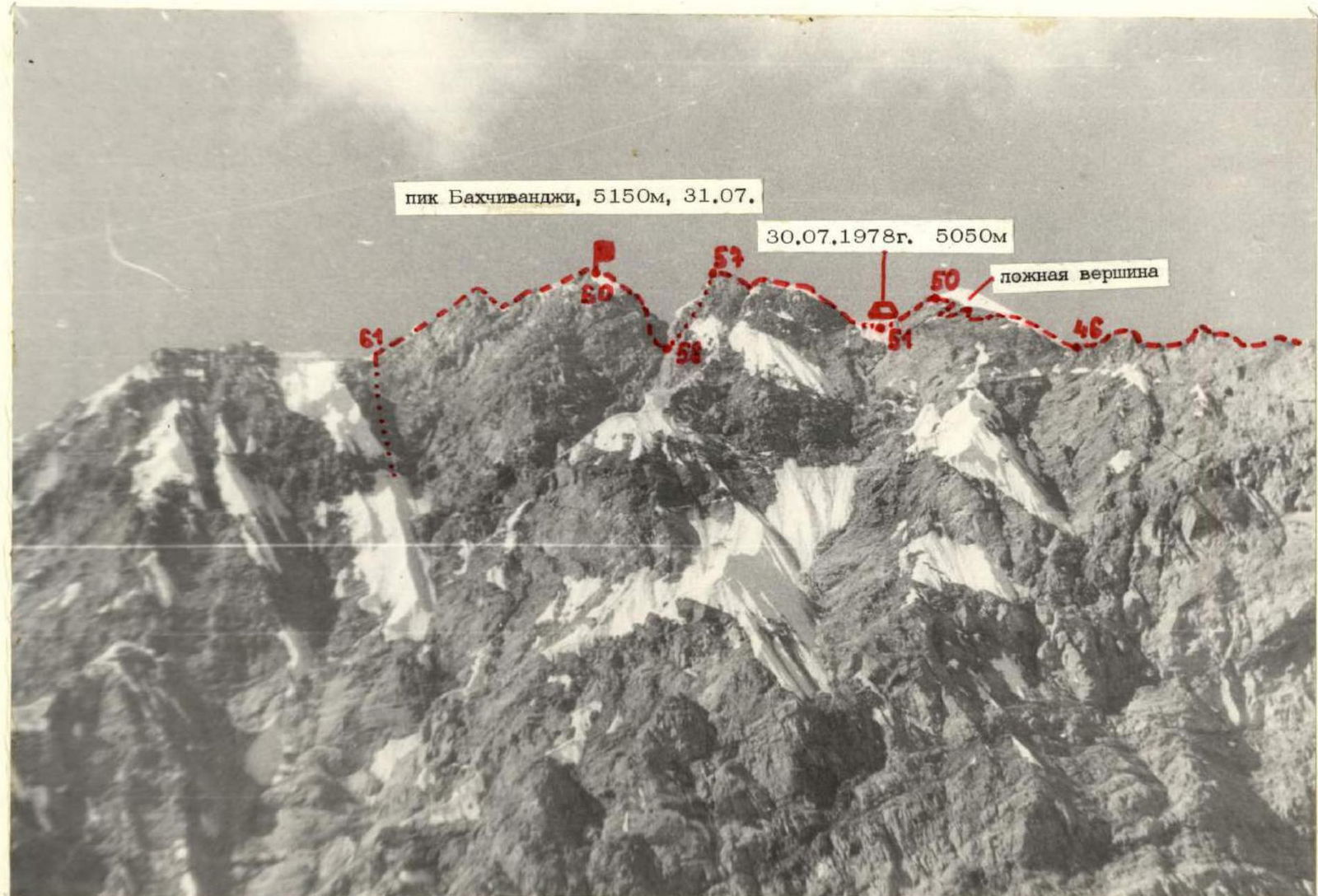
The summit is several pinnacles, heavily destroyed: — We leave a note — Having checked all pinnacles — We name the summit after the famous test pilot peak Bakhchivandzhi
Short rest. We examine the descent path. We need to descend 2 ropes along the ridge towards Arnavad and descend along a steep couloir to the south. We begin the descent. We set up 2 rappels and 4 sport climbs. Further, the couloir becomes more gentle and leads to sheep's backs. We traverse the slopes of Bakhchivandzhi, heading towards the col, and then descend along the couloir.
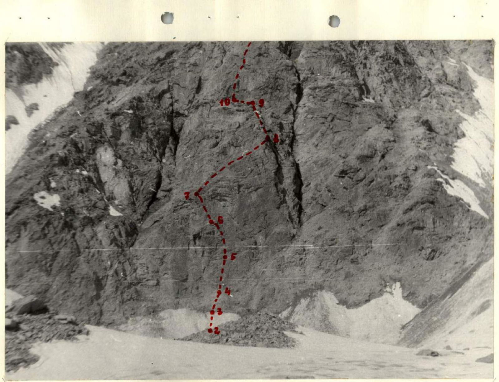
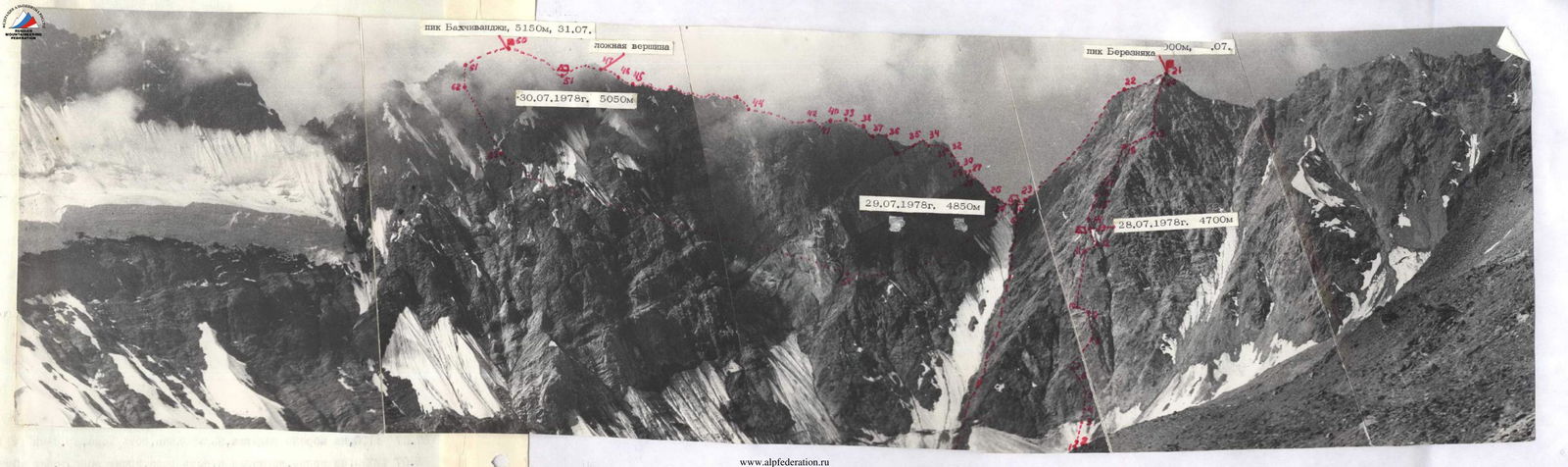
Photo 2. Lower part of the wall of peak Bereznyak sections R3–R11
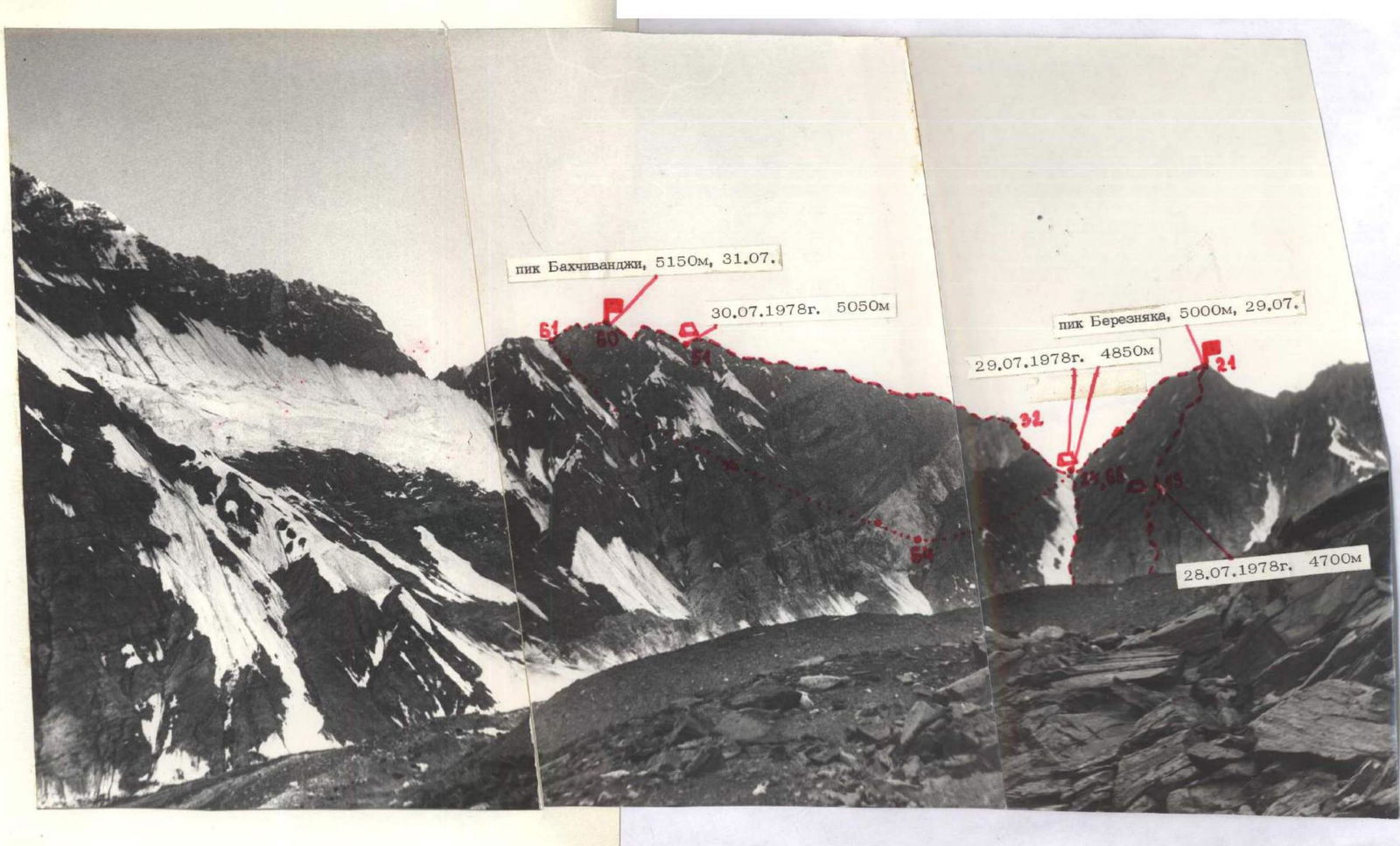
Photo 1. General view of the route.

Photo 3. Marble belt of peak Bakhchivandzhi sections R25–R36
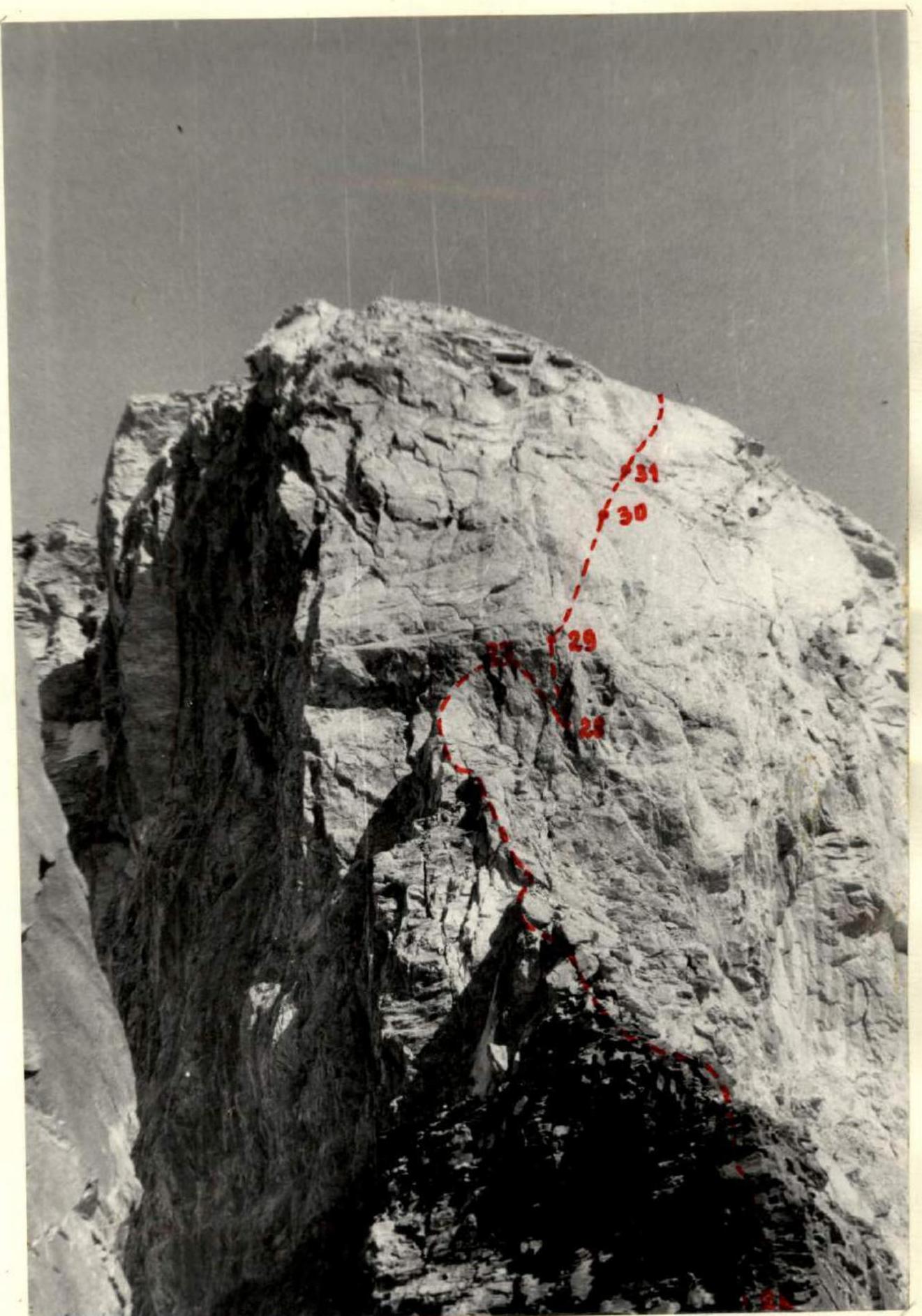
Photo 4. "Sugarloaf" of the marble belt sections R26–R31
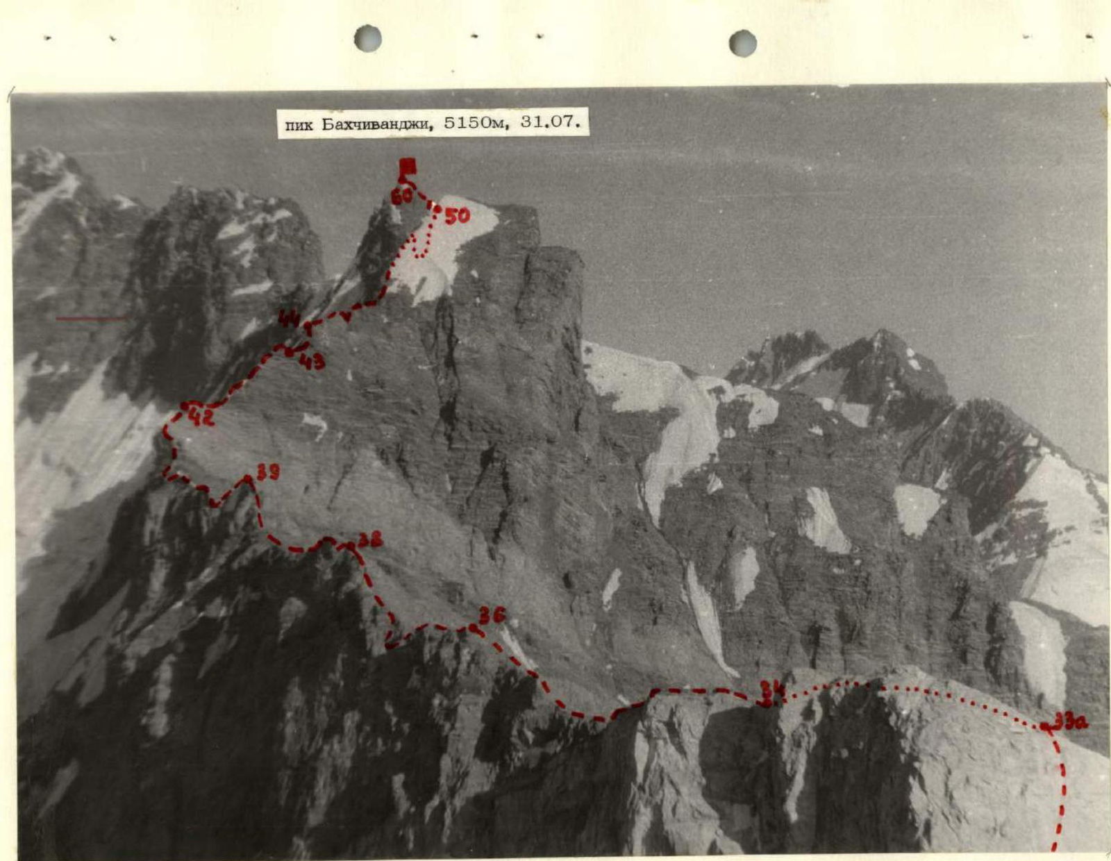
Photo 5. Ridge of peak Bakhchivandzhi sections R33–R60

Photo 7. Upper part of the ridge and summit of peak Bakhchivandzhi sections R45–R61