
Ascent Certificate
- Ascent Class: Technical
- Ascent Area: Pamir, Vanchsky Ridge
- Peak, its height, and ascent route: Shaugada 5137 m, via the North Ridge
- Proposed Difficulty Category: 4B cat. diff.
- Route Characteristics: height difference 840 m, average slope 45°. Length of sections: R1–480 m; R2–200 m; R3–160 m; R4–120 m; R5–220 m.
- Pitons hammered: — for belay: rock 22, ice 20, bolted —. — for creating ITO: —
- Number of climbing hours: 12.5
- Number of nights and their characteristics:
- Tent below the route
- Tent below the route
- Surname, name, patronymic of the leader and participants, their sports qualification:
| Surname, name, patronymic | Sports Qualification |
|---|---|
| Bakunovich Vasily Evdokimovich | 1st sports category |
| Bolotin Grigory Efimovich | 1st sports category |
| Kireev Petr Nikolaevich | 1st sports category |
| Kiselyov Georgy Konstantinovich | 1st sports category |
| Sirotin Vladimir Ilyich | 1st sports category |
| Subbotovsky Valentin Ivanovich | 2nd sports category |
| Yanitsky Lev Mikhailovich | 1st sports category |
- Team Coach: Bregman Eduard Emanuilovich
- Date of departure for the route and return: — July 15, 1979 — July 17, 1979
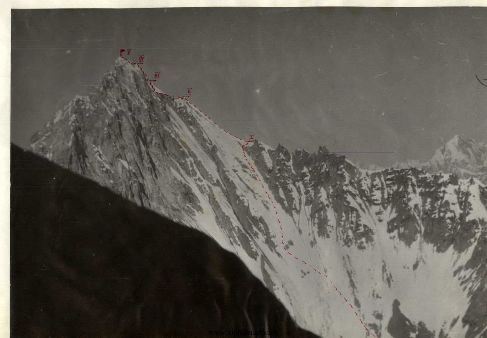
Central Pamir (diagram)
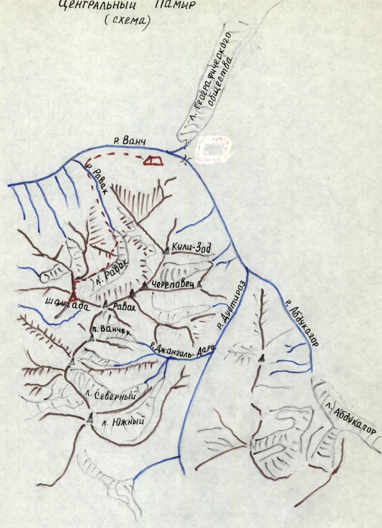
Symbols on the diagram: — base camp — path to and from the camp
Description of the approach to the route
From the base camp, located near the lakes on the bank of the Vanch River, to the Ravak gorge — 0.5–1 hour down the road. Directly from the road begins the avalanche chute, blocking the entire gorge. Ascend the avalanche chute to the Ravak glacier. Along the left moraine of the glacier, approach the icefall (2–2.5 hours). Perpendicular to the icefall is a rocky spur. Through несложным скалам, in the upper part — средней трудности, exit to the upper cirque of the Ravak glacier. Traverse along the snowy slope, through small rocky outcrops, approach the нависающие скалы (2.5–3 hours). Here is a place for overnight stays.
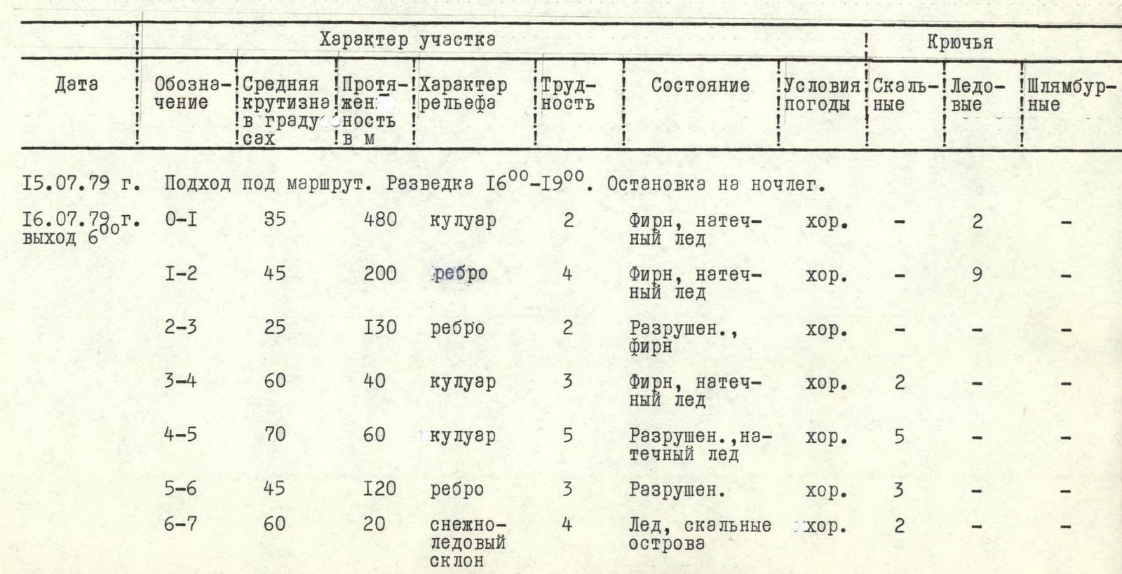
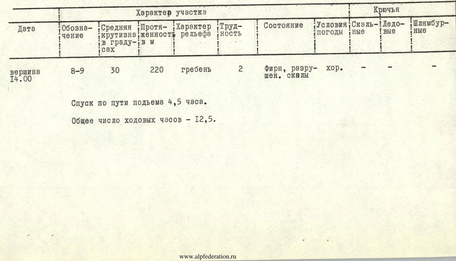
Ascent table to peak Shaugada via the North Ridge 4B cat. diff. Table I
July 15, 1979. Approach to the route. Reconnaissance 16:00–19:00. Overnight stay.
July 16, 1979. Departure 6:00.
| Designation | Average slope | Length | Terrain characteristics | Difficulty category | Condition | Weather conditions | Pitons: Rock | Pitons: Ice | Pitons: Bolted |
|---|---|---|---|---|---|---|---|---|---|
| R0–R1 | 35° | 480 m | couloir | 2 | Firn, натёчный лёд | good | — | 2 | — |
| R1–R2 | 45° | 200 m | edge | 4 | Firn, натёчный лёд | good | — | 9 | — |
| R2–R3 | 25° | 130 m | edge | 2 | Destroyed firn | good | — | — | — |
| R3–R4 | 60° | 40 m | couloir | 3 | Firn, натёчный лёд | good | 2 | — | — |
| R4–R5 | 70° | 60 m | couloir | 5 | Destroyed, натёчный лёд | good | 5 | — | — |
| R5–R6 | 45° | 120 m | edge | 3 | Destroyed | good | 3 | — | — |
| R6–R7 | 60° | 20 m | snow-ice slope | 4 | Ice, rocky islands | good | 2 | — | — |
| R7–R8 | 80° | 115 m | wall | 5 | Destroyed, натёчный лёд | good | 2 | — | — |
| Summit | |||||||||
| R8–R9 | 30° | 220 m | ridge | 2 | Firn, destroyed rocks | good | — | — | — |
Descent via the ascent route 4.5 hours. Total climbing hours: 12.5.
Brief explanation for Table I
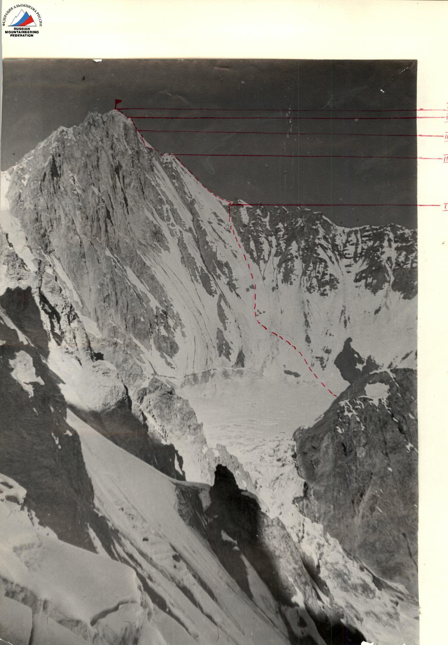
R0–R1. Snow-ice slope, in the upper part — couloir. Stay on its left side. Slope in the upper part 45–50° (crampons). Exit to the ridge.
R1–R2. Along the snow-ice slope of the ridge (45–50°) left upwards, to the flattening approximately at 200 m (crampons). Piton belay. The first person goes without a backpack.
R2–R3. Along the snowy shoulder, exit to несложные разрушенные скалы. Through them 80 m to the рыжий жандарм. Simultaneous movement.
R3–R4. Bypass жандарма to the right downwards. Belay on rocks.
R4–R5. Left upwards along the snow-ice couloir (crampons). The first person goes without a backpack. Belay on rocks on the left side of the couloir. In the upper part of the couloir, exit to the destroyed rocks средней трудности of its right side. After 20 m — exit to the ridge.
R5–R6. Along the ridge 120 m to a large stone under the yellow rocky belt. Live rocks.
R6–R7. From the large stone along the snow-ice slope — exit under the rocky wall.
R7–R8. Upwards along the strongly destroyed wall — exit to the pre-summit ridge. Live rocks. Натёчный лёд. On sections R6–R8, the first person goes without a backpack and sets up перила.
R8–R9. Along the destroyed rocks средней трудности — to the summit. Exit to the summit along snow. Caution, cornices!
No spontaneous rockfall was observed on the route, as the rocks were mostly frozen.
Comments
Sign in to leave a comment