Ascent Passport
- Ascent class: TECHNICAL CLASS.
- Ascent area: VANCH RANGE.
- Peak, its height, and ascent route: RAVAK 5232 m EASTERN RIDGE of RAVAK GLACIER.
- Estimated difficulty category: 3B
- Route characteristics:
- Height difference: 1100 m
- Average steepness: 44°
- Length I–90 m: II–990 m: III–185 m: IV–275 m: V–15 m
- Pitons driven:
- for belay
- for anchors, etc.
- Rock: 13
- Ice: 7
- Piton anchors: –
- Total travel time: 15 hours
- Number of bivouacs and their characteristics: ONE — LYING
- Full name of the leader and participants, their sports qualification:
- NAZARENKO VIKTOR GRIGORIEVICH — 1st sports category
- GRETSKY VLADIMIR VIKTOROVICH — 1st sports category
- KUKUSHKIN ALEXANDER PAVLOVICH — 2nd sports category
- Team coach: SIDELNIKOV V.N. Master of Sports of International Class
- Date of departure and return: July 30, 1979 — July 31, 1979
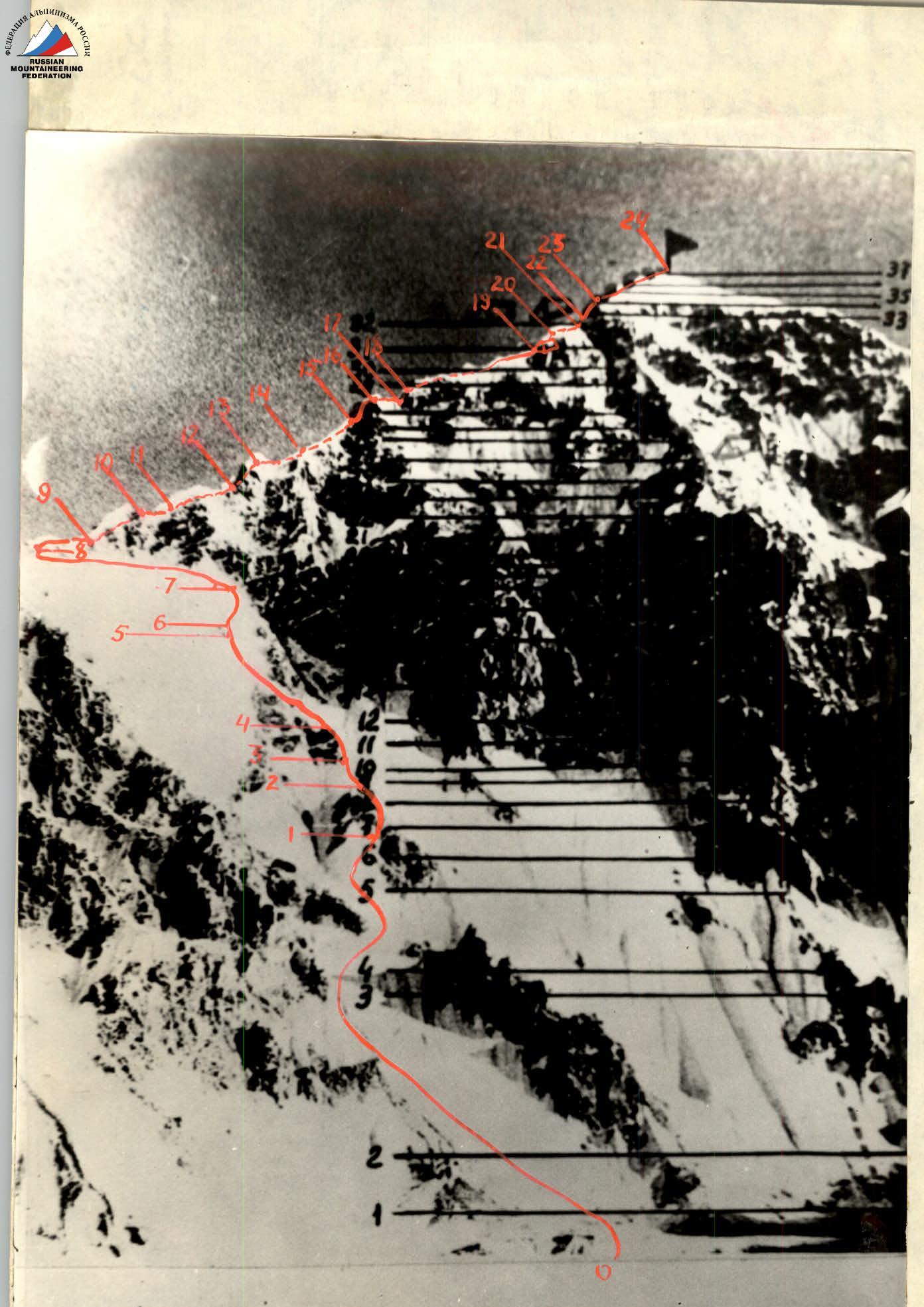
PHOTO # 1
- ASCENT ROUTE ALONG THE EASTERN RIDGE TO THE SUMMIT RAVAK.
CLASSIFIED ROUTE 5B difficulty category via the North face.
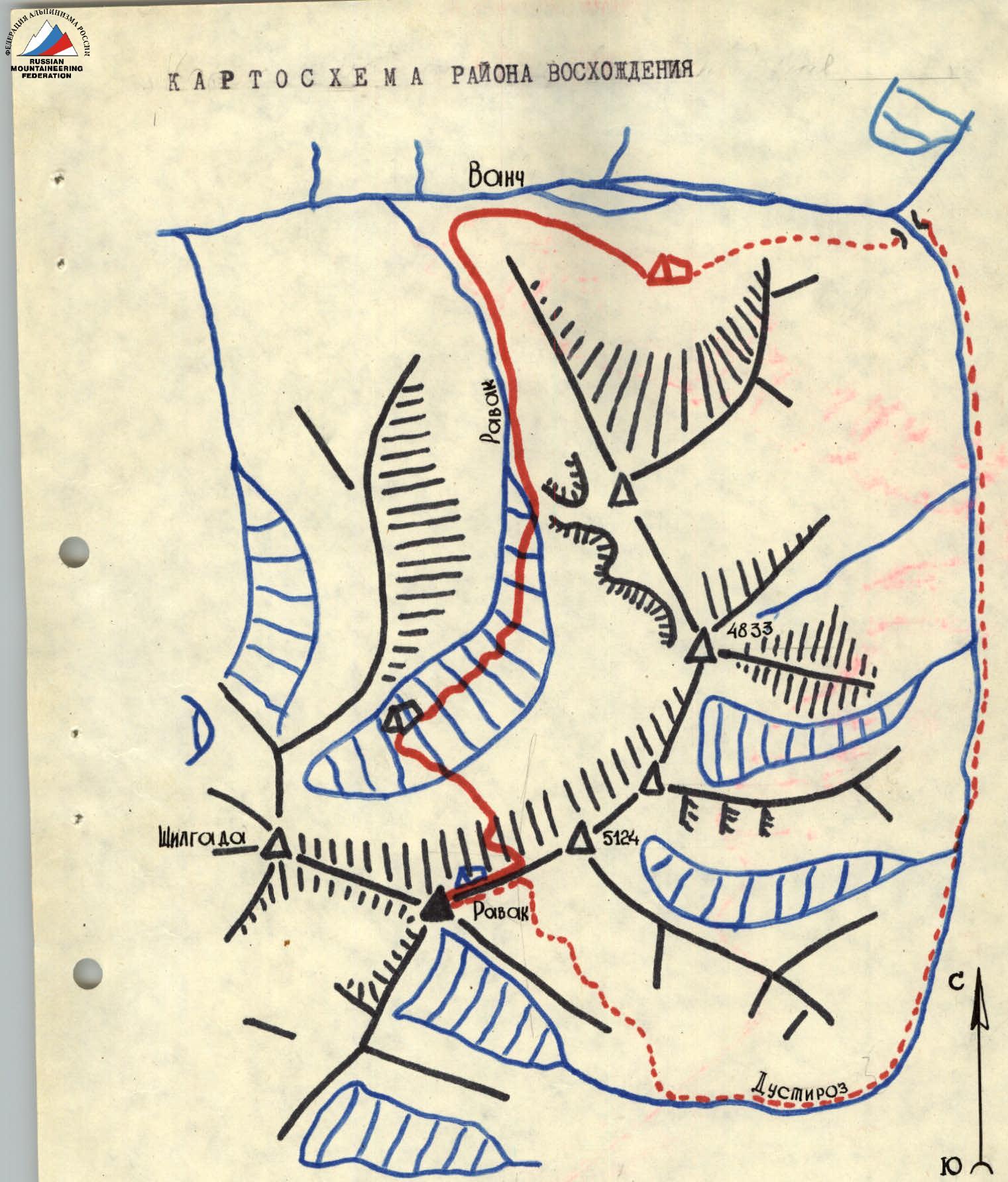
Ascent Area Map
FIG. 1
Table of Main Characteristics
| Date | Designation | Average steepness in degrees | Length in meters | Terrain characteristics | Difficulty | Condition | Weather conditions | Pitons (Rock) | Pitons (Ice) | Notes |
|---|---|---|---|---|---|---|---|---|---|---|
| 30.07.1979 | R0–R1 | 25 | 270 | Firn slope | 2 | Hard firn | good | single | – | – |
| R1–R2 | 60 | 55 | Wall | 4 | Destroyed rocks | –"– | 24 | 6В | – | |
| R2–R3 | 45 | 40 | Ice slope | 3 | Ice | –"– | transverse | 3 | – | |
| R3–R4 | 45 | 60 | Ridge | 4 | Destroyed rocks | –"– | 3 | 4В | – | |
| R4–R5 | 20 | 150 | Snow ridge | 2 | Snow | –"– | single | – | – | |
| R5–R6 | 20 | Snow shelf | 1 | Snow | –"– | single | – | – | ||
| R6–R7 | 48 | 60 | Ice slope | 4 | Ice | –"– | transverse | 3 | – | |
| R7–R8 | 15 | 230 | Snow slope | 2 | Snow | –"– | single | – | traverse | |
| R8–R9 | 35 | Snow col | 1 | Snow | –"– | single | – | col | ||
| R9–R10 | 45 | 30 | Ridge | 3 | Monolith | –"– | transverse | – | – | |
| R10–R11 | 15 | Snow shelf | 1 | Snow | –"– | single | – | – | ||
| R11–R12 | 35 | 20 | Snow ridge | 2 | Snow | –"– | single | – | – | |
| 31.07.1979 | R12–R13 | 10 | 35 | Snow ridge | 2 | Snow | –"– | single | – | – |
| R13–R14 | 30 | 20 | Ridge | 2 | Destroyed rocks | –"– | single | – | Control cairn | |
| R14–R15 | 15 | 50 | Snow ridge | 3 | Snow | –"– | single | – | – | |
| R15–R16 | 55 | 65 | Couloir | 4 | Icy rocks | –"– | 5 | 2В | – | |
| R16–R17 | 20 | 55 | Ridge | 2 | Snow-covered rocks | –"– | single | – | – | |
| R17–R18 | 70 | 15 | Wall | 5 | Monolith | –"– | 3 | – | – | |
| R18–R19 | 5 | 20 | Snow ridge | 1 | Snow | –"– | single | – | Bivouac | |
| R19–R20 | 25 | 35 | Ridge | 3 | Snow-covered destroyed rocks | –"– | transverse | – | – | |
| R20–R21 | 45 | 25 | Snow ridge | 4 | Soaked snow | –"– | transverse | – | – | |
| R21–R22 | 65 | 10 | Small wall | 4 | Snow-covered rocks | –"– | 2В | – | – | |
| R22–R23 | 45 | 30 | Snow ridge | 3 | Snow | –"– | transverse | – | – | |
| R23–R24 | 5–10 | 200 | Snow ridge | 2 | Snow | –"– | single | – | Summit |
Description of the route to peak Ravak via 3B category of difficulty (approximately)
From the base camp to the Ravak River, it takes 1 hour. Then, along the right (orographically) bank of the Ravak River into the eponymous gorge. Further, along the snowfields and moraines of the Ravak Glacier to the snow plateau of the cirque. Travel time is 4–5 hours. Bivouac. Through the icefall to the upper reaches of the Ravak Glacier under the bergschrund, time is 30–40 minutes.
The route begins with overcoming the marginal crevasse along the avalanche chute. It is recommended to start early in the morning, as rockfall from the walls of peak Ravak is possible. Movement in teams along a moderately steep firn slope to a rocky outcrop is simultaneous. The ascent to the rocky outcrop is via a moderately steep ridge; the rocks are destroyed; protection is via pitons and rock features. Further, in crampons, movement is alternate. The ice slope is traversed from left to right in the direction of the rocky outcrop. The steepness of the ice is 45°. Protection is via pitons. The ascent to the second rocky outcrop is via a ridge of moderate steepness; the rocks are destroyed; protection is via pitons and rock features. Then, along a snowy ridge crest, to a snow cushion, from where a traverse along a snowy-icy slope leads to a col. Travel time from the bergschrund to the col is 5–6 hours, depending on the condition of the snowy-icy slope.
The route continues along the ridge from east to west towards the summit. The bypass of gendarmes is mostly on the left as you go. Movement along the eastern ridge begins with overcoming a moderately steep snowy slope, to the right as you go, dropping off towards the Ravak Glacier; the slope leads under the first gendarme. It consists of monolithic snow-covered rocks with good features for organizing protection; movement is simultaneous. Further, along the snowy ridge to a rocky ridge, steepness is 30°; on the right, there are snowy cornices. Movement is simultaneous; protection is via rock features. Control cairn.
A moderately steep snowy ridge leads to the second gendarme. The gendarme is overcome by first moving 7 meters to the left along the snow, then up a rocky couloir; the rocks are partially covered with ice; protection is via pitons. Steepness is 45°; the rocks are of 4th category of difficulty; after 1.5 rope lengths, there is an exit to a snowy rocky ridge that leads to the third gendarme.
The third gendarme consists of monolithic rocks and is overcome directly upwards along a rocky wall, height is 15 m, steepness is 70°; protection is via pitons, 5th category of difficulty. Then, a gently sloping snowy ridge where a good bivouac can be organized on the snowy ridge. Travel time from the col to the bivouac is 3.5–5 hours.
The ridge leads to a heavily snow-covered talus slope, one rope length. Further, a snowy ridge with soaked wet snow. The next rocky wall is overcome to the left and upwards. Snow-covered rocks; difficult climbing; then a steep snowy ascent that becomes more gentle after 30 m and leads to the summit. Cairn on rocks to the right of the snowy cornice.
Descent is possible via two options:
- The first is down the ascent route to the snowy col to the bivouac on the Ravak Glacier. Descent is possible in the first half of the day.
- The second is down the ridge to the col, then down towards the Dustiroz gorge and along the eponymous river, initially down the left (orographically) bank to the foot of the Medvezhiy Glacier, through the glaciers, and via a detour on the road to the base camp.
Leader (Nazarenko V.G.) Coach Master of Sports of International Class (Sidelnikov V.N.)