I. Climbing class — technically challenging.
- Climbing area — Central Pamir, Northern spur of the Vanch ridge, upper reaches of the Dustiroz river gorge.
- Climbing route — peak "5307" via the Northern counterfort from the moraine of the Pravy Dustagor glacier.
- Climbing characteristics:
elevation gain — about 1600 m, average steepness — 45–50°, length of the challenging section — about 1100 m in height, starting from approximately 4000 m above sea level and up to the pre-summit ridge; total length of key sections — about 200 m.
- Pitons hammered: rock — 62, ice — 20, bolted pitons — not used.
- Total climbing hours — 36 (ascent — 27, descent — 9).
- Number of bivouacs and their characteristics: total — 3 (two during ascent, one during descent). First bivouac at an altitude of about 4200 m. Can lay out a site for one tent. No water. Snow. Second bivouac on a shelf at an altitude of about 4750 m. Sitting bivouac. Safe. No water. Snow. Third bivouac on the Western ridge, 150–200 m beyond the summit. Can lay out a site for one or two tents. No water. Ice, snow.
- Team name — sports group of the "Vysochnik" alpine camp, combined team from Gorky (SDSO "Burevestnik", DSO "Trud").
- Surname, name, patronymic of the team leader, participants, and their qualification: Rodionov Sergey Nikolaevich (leader) — 1st sports category, Vyshinsky Nikolay Nikolaevich — 1st sports category, instructor, Borisov Gennady Konstantinovich — 2nd sports category, instructor, Vavilov Alexander Ivanovich — 2nd sports category, instructor.
- Team coaches — CMS, instructor Zaplatkin Vladimir Pavlovich ("Trud"), instructor Vyshinsky Nikolay Nikolaevich ("Burevestnik").
- Date of departure to the route and return to the camp — departure from the "Vysochnik" alpine camp — August 22, 1974, departure to the route — August 23, 1974, return to the "Vysochnik" alpine camp — August 27, 1974.
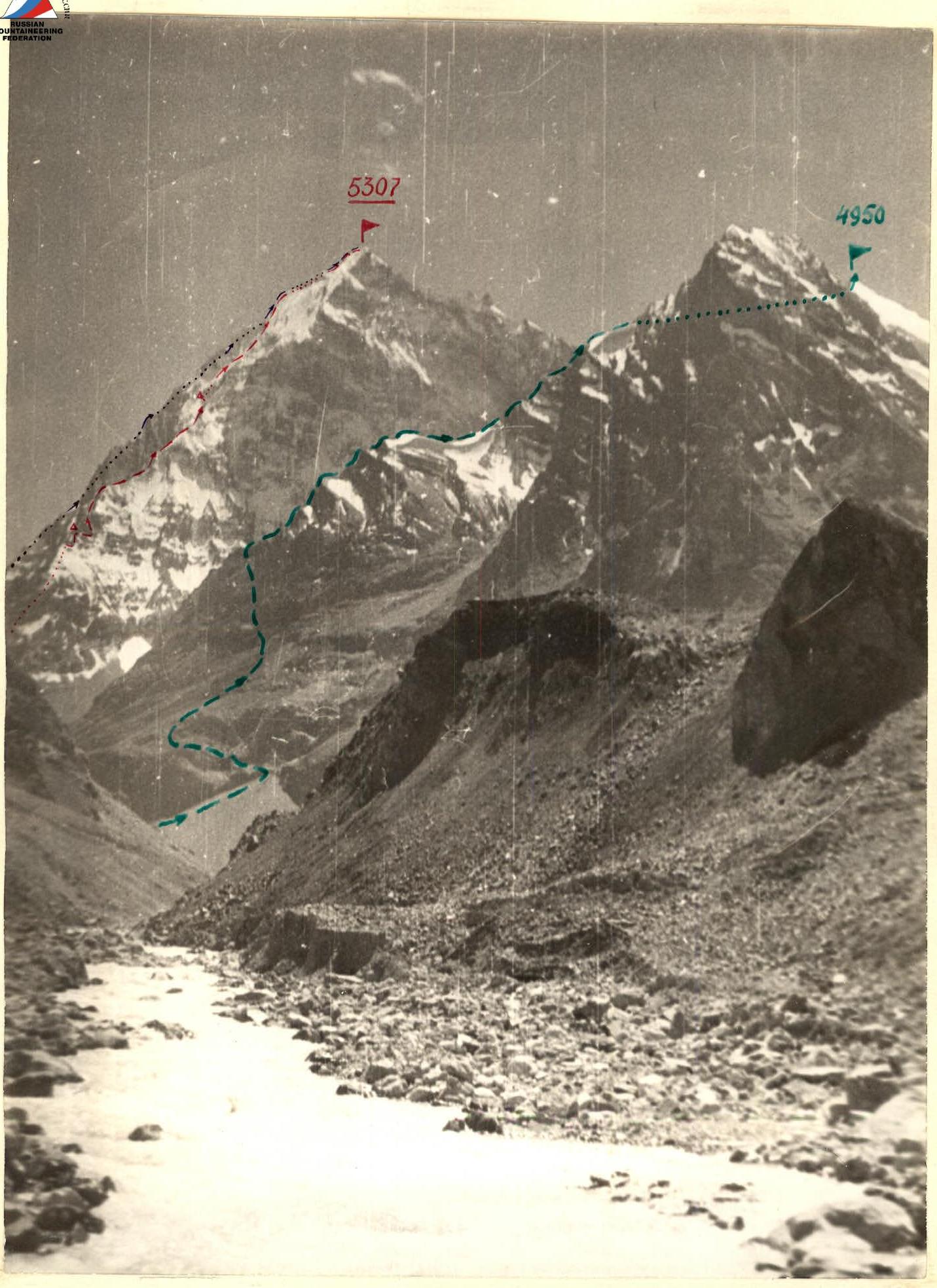
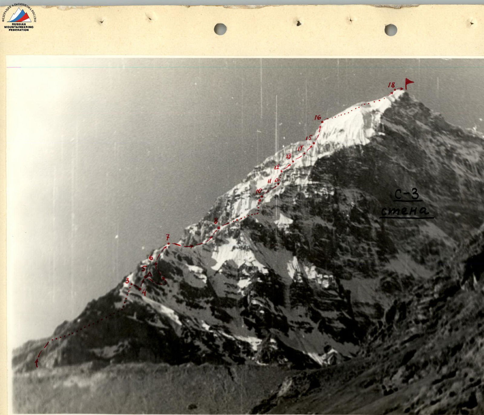
View of peaks "5307" and "4950" from NW from the Dustiroz river valley
- route to peak "5307" via N. counterfort
- route of Malyshev V.N.'s group
- route of Mironychev M.S.'s group
Brief characteristic of the area
The work of the sports groups of the "Vysochnik" alpine camp was concentrated in the area of the Geographical Society glacier, Abdukagor, and in the Dustiroz river gorge, where there are many unconquered peaks in the southern spurs of the Darvaz ridge and the northern spurs of the Vanch ridge, presenting a sporting interest. Some of them are not even marked on the map.
A peculiarity of climbs in this area is its remoteness from populated areas and alpine bases. This circumstance requires organizing supplies of equipment, food, and fuel for an extended period.
Due to the movement of the Medvezhiy glacier, some communication paths are currently disrupted. Ice avalanches are quite frequent in the area of the glacier tongue. The accompanying floods wash away bridges connecting the upper reaches of the Vanch river gorge with its tributary gorges, particularly the Dustiroz river gorge.
Like other Pamir regions, this area is characterized by sparse vegetation and a practical absence of forests. The weather is generally stable. Precipitation is low, and strong winds are frequent.
When organizing climbs, a clear plan for the interaction of sports and observation groups is necessary.
The base camp "Vyso highlighted in front of the left-bank moraine of the Geographical Society glacier, at the junction of trails coming from the Abdukagor river gorge (through the Medvezhiy glacier tongue) and from the area of the Kasal-Ayak pass.
The main object of the ascent was planned to be peak "5307", located in the northern spur of the Vanch ridge in the upper reaches of the Dustiroz river gorge. It was planned to ascend the northern counterfort of the peak with the strongest group.
Two other groups were to simultaneously start the assault:
- peak "5307" via the NE ridge,
- unnamed peak "4950" from the NE.
The observation group and the team doctor were to be based on a clearing located east of the confluence of rivers flowing from the Pravy and Levy Dustagor glaciers. This clearing is 8 hours' walk from the "Vysochnik" base camp and approximately 3.5–4 hours' walk from the bivouac near the confluence of the Djangaldara and Dustiroz rivers.
The path from the base camp to the bivouac initially follows a well-trodden automobile road towards the Medvezhiy glacier tongue along the right bank of the river. About 500 m below the tongue, there is a trail leading through two bridges to the left bank of the river.
Further, the trail:
- bypasses the glacier tongue,
- ascends in a "serpentine" to an abandoned road on the left orographic slope of the Dustiroz river gorge.
About halfway between the "serpentine" and the bivouac, the road is interrupted by a waterfall; the trail in this area follows a very steep slope composed of sedimentary rocks heavily eroded by floodwaters. Crossing to the bivouac over the Djangaldara river during the gathering did not present serious difficulties.
From the bivouac, the trail follows a meadow and sparse forest along the left bank of the Dustiroz river. After 40–50 minutes of walking, it descends to the river and follows the edge of the bank, sometimes interrupted by steep talus and mudflows. In some places, the trail disappears, and one has to navigate through rocks protruding from the water, holding onto the almost sheer clayey bank.
It should be borne in mind that high water in the second half of the day makes crossing the Levy Dustiroz river practically impossible. Convenient places for bivouacs are located:
- at the bivouac,
- on the high left bank of the Dustiroz river at the crossing over the Levy Dustiroz (there are clean lakes nearby),
- near a spring, 30–40 minutes' walk beyond the crossing.
Organizational and tactical plan
The Gorky team of climbers, upon arrival at the high-mountain base of the "Vysochnik" alpine camp, drew up a work plan, according to which a training cycle of rock and snow-ice training was conducted.
On August 15, after completing the training cycle, the group embarked on a training ascent and reconnaissance of the intended area. The camp was set up near the bivouac, 4–4.5 hours' walk from the "Vysochnik" base camp.
The first ascent to a peak of category 2B difficulty was made by the entire Gorky group on August 16. This peak is located in the upper reaches of the Djangaldara gorge.
On August 17, reconnaissance of the area was conducted by two groups. One group, led by Vyshinsky N.N., explored the area of the Djangaldara river gorge and reconnoitered the approach to the peak planned for the second ascent. This peak, with a route of approximately category 3B difficulty and a height of about 4900 m, is located in the ridge extending in a southeast direction from peak "5182".
The second reconnaissance group, led by Rodionov S.N., explored the upper reaches of the Dustiroz gorge and approached peak "5307". Two routes were examined on this peak, planned for subsequent ascents:
- via the northern counterfort,
- via the NE ridge.
Both routes are approximately category 5B difficulty. Nearby stands a peak not marked on the map, with a height of about 4950 m. A route via the NE ridge, approximately category 4B difficulty, was planned for this peak.
On August 18, two groups of 6 people each made an ascent to peak "4900" via a route of category 3B difficulty:
- One group was led by Zaplatkin V.P.
- The second group was led by Vyshinsky N.N.
On August 19, they descended to the "Vysochnik" base camp. On August 20, after discussing the completed ascents, a decision was made: two sports groups, each consisting of 4 people, would ascend peak "5307".
- One group, led by Rodionov S.N., would ascend via the northern counterfort.
- The second group, led by Malyshev V.N., would ascend via the NE ridge.
- The third group, led by Mironychev M.S., would ascend peak "4950" via the NE ridge.
All three groups were to start the route simultaneously and maintain constant radio communication. The observation group, consisting of CMS Zaplatkin V.P. and the doctor of the Gorky group, Kitaeva N.D., would maintain communication with the climbers and the "Vysochnik" alpine camp. This plan was fully approved by the camp leadership.
Equipment preparation
The route used equipment from the "Vysochnik" alpine camp, as well as a set of rock and ice pitons made of titanium, which ensured reliable insurance on all sections of the route. For a group of 4 people, the following equipment was taken on the route:
- Equipment from the "Vysochnik" alpine camp
- Set of rock pitons made of titanium
- Set of ice pitons made of titanium
Nutrition
When selecting products, the group was guided by the individual tastes of the participants and the available range of products at the "Vysochnik" alpine camp base. The product set included:
- sugar
- chocolate
- instant coffee
- condensed milk
- canned beef
- dried oscietra
- concentrates
- cereals
- fresh onions
- salt
- and others.
The group had a supply of products for 4 days.
The total weight of equipment and food was approximately 85 kg.
Route description
On August 22, the group departed from the "Vysochnik" base camp at 8:00 and reached the bivouac near the confluence of the Djangaldara and Dustiroz rivers by approximately 13:00. After a short rest, the assault groups and the observation group proceeded up the Dustiroz river gorge. Around 18:00, all participants reached the crossing over the Levy Dustiroz river and set up for the night on a high river terrace near lakes.
On August 23, at 6:30, the groups crossed the Levy Dustiroz river and reached a clearing near a spring by around 7:30. While the observation group set up a camp, the assault groups, after checking their equipment and clarifying communication and signaling conditions, set off on their routes.
Peak "5307" is located in the northern spur of the Vanch ridge, which divides the Dustagor glacier into Levy and Pravy Dustagor.
To the northwest of this peak, a ridge extends, which then:
- turns north,
- ends near the confluence of rivers flowing from the Levy and Pravy Dustagor glaciers.
The northern counterfort is bounded:
- to the east by steep, almost sheer rock descents,
- to the west by snow-ice slopes leading to the western wall.
The difference in height between the moraine at the base of the counterfort and the highest point of the peak is about 1600 m. The average steepness of the route is 45–50°.
The initial section of the route (R0–R1) is a steep talus ending in a rock wall with an internal angle (5–7 m), which is traversed with alternating belay.
Section (R1–R2) consists of heavily destroyed rocks of medium difficulty. The length of this section is about 250–300 m in height. It features steep rock slabs with few holds and sections up to 7 m long.
Further (R2–R3), the route follows steep, fairly solid rocks leading to a 40-meter internal angle. The upper part of this section is almost vertical (15–20 m). It is traversed with piton belay. Climbing is free but challenging.
Section (R3–R4) is relatively simple but requires careful belay. It leads to a vertical internal angle (R4–R5), 25–30 m long, with few holds. Climbing on this section is challenging and requires careful piton belay. This section leads to a small, snow-covered inclined platform. After clearing, it is suitable for setting up one tent.
The group reached the platform on August 23, 1974, at 17:30 and began organizing a bivouac.
- The team (Rodionov — Vavilov) went on reconnaissance and route processing.
- The others started preparing food.
On the ridge, at the start of the internal angle (R4) and above the bivouac site (R5), there are areas suitable for clearing and tent setup. No water. Snow.
At 21:00, radio communication was conducted (the last for that day) with Malyshev's and Mironychev's groups. Additionally, visual communication was established with Mironychev's group using an electric flashlight to clarify the groups' positions on the routes.
A control cairn was set up at the bivouac site (R5). On August 24, the group departed on the route at 8:00. Following the previously laid fixed ropes from the bivouac site, they moved right along a shelf and then straight up steep rock descents to the ridge, where there is a platform suitable for a bivouac.
Further, there is a snow-ice ridge ascent (R7–R8) leading to steep rock sections covered with rime ice (R8–R9). The most challenging part in this area is 40–45 m long. Climbing is very difficult. The first climber traverses this section without a backpack, with careful piton belay.
Then the route follows three rock walls, each 30–35 m long (R9–R10). Climbing is challenging, with piton belay. The last, most challenging and steep (about 80°) wall leads to a rock ridge with rime ice (R10–R11). The rocks are destroyed and covered in ice. Steepness is 60–65°. Belay is provided using ice pitons hammered into wide rock cracks. The ridge leads to a sheer wall with an inclined shelf (R11), where a sitting bivouac can be organized.
The group reached the bivouac site (R11) on August 24, 1974, at 20:30. Conditions for organizing a bivouac are satisfactory. The site is safe. At 21:00, the last radio communication was conducted with Malyshev's and Mironychev's groups and the observation group.
On August 25, the group departed on the route at 8:30. Overcoming the sheer wall above the bivouac site (R11) is done from the left (R11–R12) via ice-covered, almost vertical rocks (25–30 m). Climbing is very challenging; the first climber traverses this section without a backpack. Careful piton belay is required.
Next, there is a series of snow-ice ascents (R12–R13) and (R13–R14), each 40–60 m long, with the upper part having a steepness of up to 60°. Sections leading to the pre-summit ridge (R14–R15) and (R15–R16) are ice-covered rock descents with a steepness of 55–60°. Climbing is challenging, with piton belay; possible falling rocks.
The section of the route from the wall above the last bivouac to the snow ascents of the pre-summit dome should be traversed in crampons.
Snow ascents of the pre-summit dome (R16–R17) and (R17–R18) have an average steepness of no more than 45°. The upper part of these ascents is steeper. The ascent to the summit (R19) is made through a snow-ice cornice (R18). The group reached the summit on August 25, 1974, at 16:30. They found a note from Malyshev's group, who reached the summit an hour earlier via the NE ridge. The weather is deteriorating. They decide to spend the night near the summit. Descent from the summit began at 17:00. After 15 minutes, they stopped for the night on the Western ridge, before a dip, 150–200 m beyond the summit, and approximately the same distance below it in height. They leveled the site and set up a tent. A strong snowfall and blizzard began.
On August 26, the descent continued at 7:00. The weather is good. Descent into the dip (35 m) is done by rappelling. Further, the path continues left (about 80 m) along an icy, steep couloir to a steep ice-snow slope. This slope, about 300 m long, leads to the glacier. Along the glacier, staying on its right side, they reached a saddle. From the saddle, they descended via snow-covered slopes and "goat's foreheads" to the start of the route.
The route was completed on August 26, 1974, at 16:00.
Thus, the group consisting of:
- Rodionov S.N. (leader),
- Vyshinsky N.N.,
- Borisov G.K.,
- Vavilov A.I., made a first ascent via the northern counterfort of peak "5307" from August 23 to August 26, 1974.
Leader: Rodionov S.N. Participants: Vyshinsky N.N., Borisov G.K., Vavilov A.I.
TABLE OF MAIN CHARACTERISTICS OF THE CLIMBING ROUTE. The route of ascent to peak "5307" via the northern counterfort, traversed by the "Vysochnik" alpine camp team led by Rodionov S.N. from August 23 to August 26, 1974.
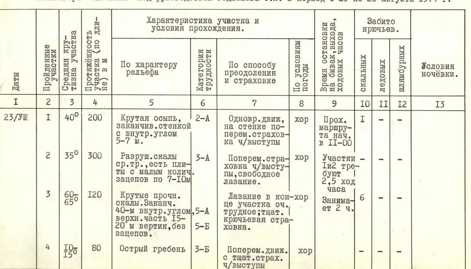
| Dates | Sections traversed | Average steepness of section | Length of section (in meters) | Character of relief | Category of difficulty | Method of traversal and belay | Weather conditions | Time of bivouac, departure, climbing hours | Pitons hammered (rock) | Pitons hammered (ice) | Pitons hammered (bolted) | Bivouac conditions |
|---|---|---|---|---|---|---|---|---|---|---|---|---|
| 23/VIII | R0–R1 | 40° | 200 | Steep talus ending in a wall with an internal angle 5–7 m. | 2А | Simultaneous movement, good belay on the wall through ledges | good | Traversal of R0–R1 began at 11:00 | 1 | – | – | |
| R1–R2 | 35° | 300 | Destroyed rocks of medium difficulty, featuring slabs with few holds up to 7–10 m | 3А | Alternating belay through ledges, free climbing | good | Sections R1–R2 require 2.5 climbing hours | – | – | |||
| R2–R3 | 60–65° | 120 | Steep, solid rocks. Ending in a 40-meter internal angle, upper part 15–20 m vertical, without holds. | 5А, 5Б | Climbing on the upper part is very challenging; careful piton belay | good | Takes 2 hours. | 6 | – | – | No suitable sites for tent setup on sections R2–R10! | |
| R3–R4 | 10–15° | 80 | Sharp ridge | 3Б | Alternating movement with careful belay through ledges | good | – | – | ||||
| 23/VIII | R4–R5 | 70–75° | 60 | Internal angle, upper part 25–30 m smooth | 5Б | Very challenging climbing using artificial holds; careful piton belay | good | Requires more than 1.5 hours. Bivouac at 17:30 | 7 | – | – | Inclined shelf, snow-covered; can lay out a site for one tent; no water, snow–ice |
| 24/VIII | R5–R6 | 55–60° | 120 | Horizontal shelf, vertical couloir | 4А | Free climbing, good piton belay | good | Departure at 8:00 | 4 | – | – | |
| R6–R7 | 55° | 120 | Steep rock descents on the ridge | 4Б | Climbing not very challenging, good piton belay | good | Traversal of R5–R7 takes about 3 hours. | – | – | |||
| R7–R8 | 35° | 320 | Snow-ice ridge ascent | 5А | Challenging climbing, good, careful piton belay | good | Requires 3 climbing hours. | 8 | 2 | – | ||
| R8–R9 | 30° | 220 | Rock sections with rime ice; sheer drop 40–45 m | More than 5Б | Challenging climbing; on the sheer drop very challenging, first traverses without backpack. Belay is combined and very careful. | good | Requires 3 climbing hours. | 6 | 2 | – | ||
| R9–R10 | 75–80° | 90 | Three rock walls, 25–30 m each | 5Б | Challenging climbing: last 30 m very challenging, careful piton belay. | satisfactory | Requires at least 2 hours. | 9 | – | – | ||
| R10–R11 | 60° | 120 | Steep rock ridge with rime ice; rocks destroyed | 5А | Challenging climbing, satisfactory, careful piton belay | satisfactory | Bivouac at 20:30 | 4 | – | – | Under wall R11, sitting bivouac on an inclined shelf; safe; no water, snow–ice. | |
| 25/VIII | R11–R12 | 75–80° | 30 | Ice-covered sheer wall | 5Б | Very challenging climbing; first traverses without backpack. | good | Departure at 8:30 | 4 | 1 | – | Sitting bivouac conditions are satisfactory. Legs need to be kept warm. Recommended to organize a belay station. |
| R12–R13 | 45° | 80 | Snow-ice slope; upper part has 60° | 4А | Alternating movement in crampons; piton belay and through ice axe. | 2 | – | |||||
| R13–R14 | 45° | 80 | Same | 4А | Same | good | 2 | – | ||||
| R14–R15 | 50° | 100 | Ice-covered rock descents. | 5А | Challenging climbing, good piton belay. | Requires about 2 hours. | 3 | 2 | – | |||
| R15–R16 | 65° | 60 | Ice-covered sheer wall | 5Б | Very challenging climbing, good, careful piton belay. | good | Requires more than 2 hours. | 4 | 4 | – | ||
| R16–R17 | 30–35° | 220 | Ascent to the pre-summit dome; upper part steeper. Cornice on the right!!! | 3А | Simultaneous and alternating movement; belay through ice axe. | satisfactory | – | – | ||||
| R17–R18 | Same | 240 | Same. Upper part features a snow-ice cornice | 3Б | Same. Particularly careful belay when traversing the cornice. | satisfactory | 1 | – | ||||
| R18–R19 | 60 | Gentle ascent to the summit. | Gusty wind, sleet, snow. | Summit reached at 16:30 | Bivouac on an inclined site, 150–200 m from the summit. |
Team captain: Rodionov S.N.
Team coaches: Zaplatkin V.P., Vyshinsky N.N.
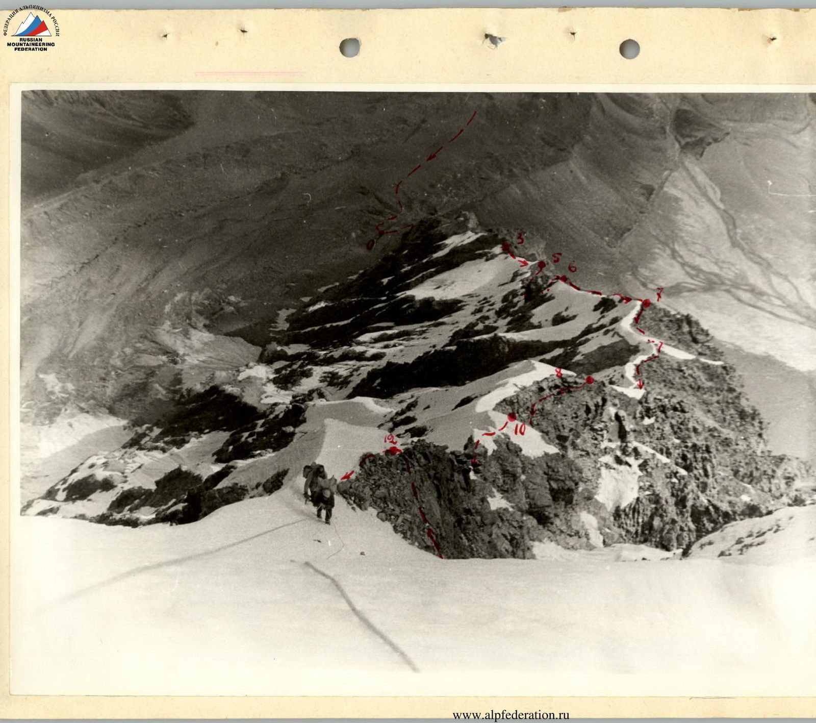
View from the top of the N. counterfort of peak "5307". Moment of traversing the snow-ice ascent (R12–R13).
Path of descent from the saddle between peaks "5307" and "4950" to the north.
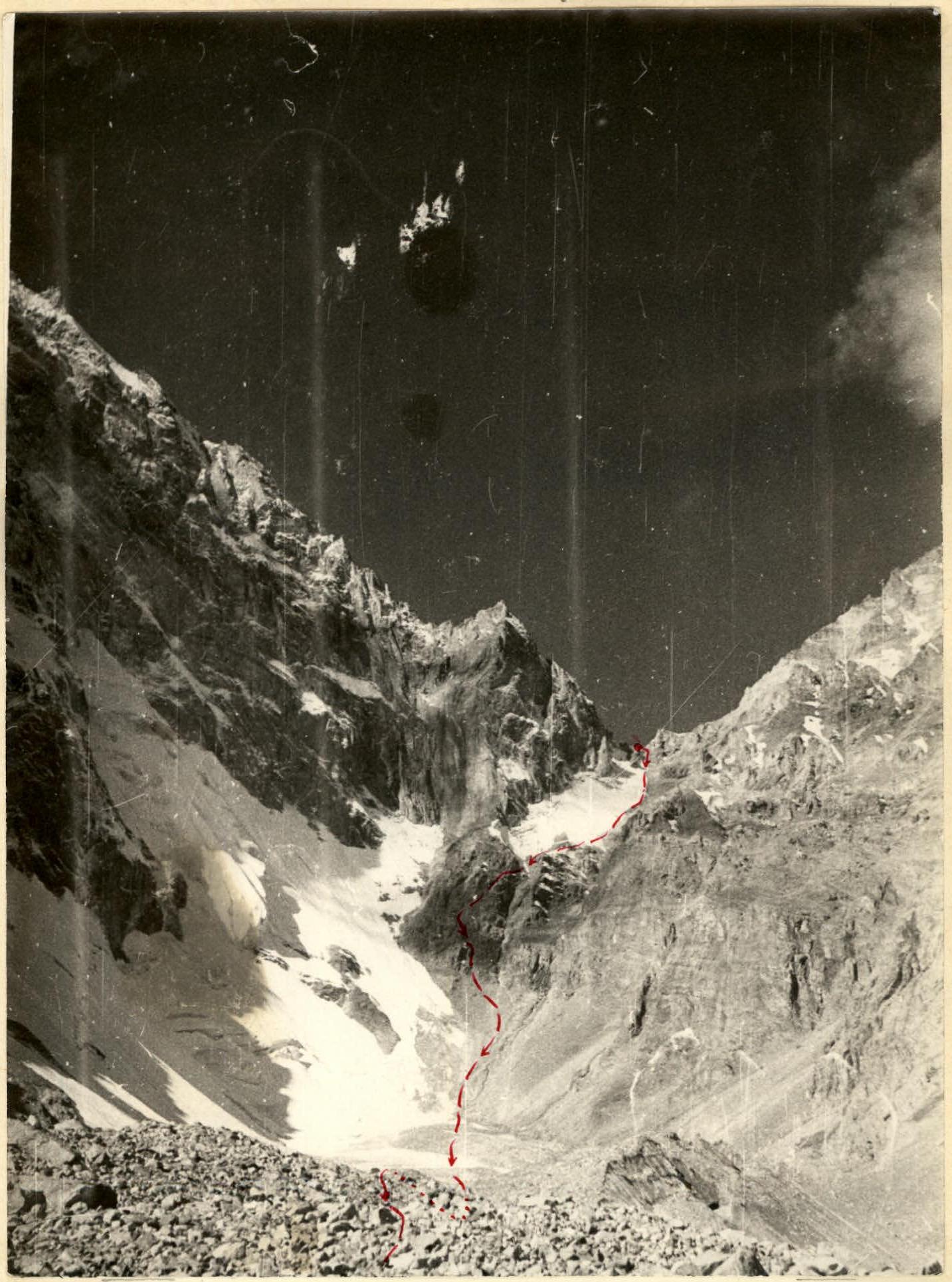
View of the N. counterfort of peak "5307" from below, from the observation group's location.
→ — visible path.
… — invisible path.
Δ — bivouac locations on the route.
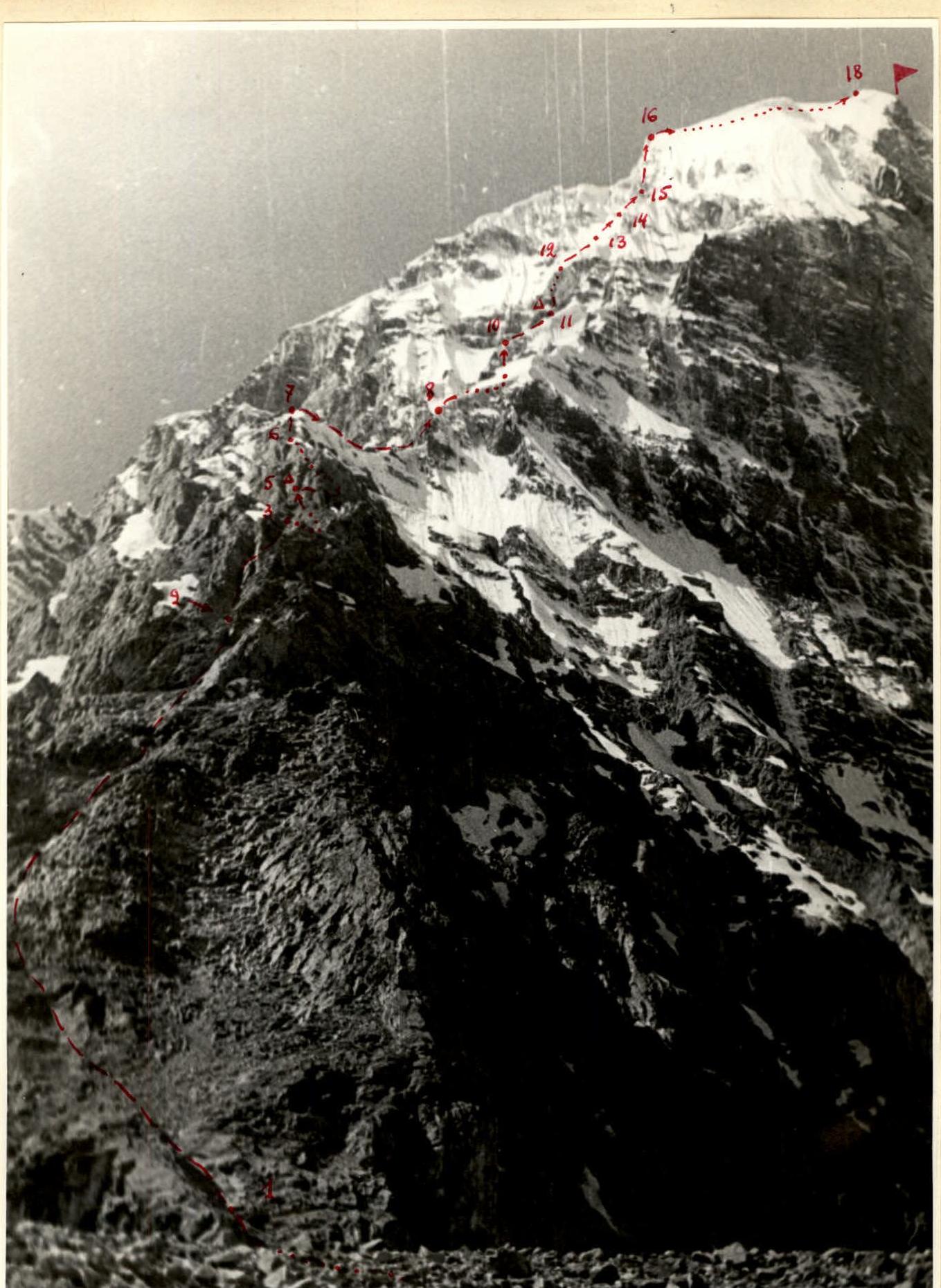
View of the Northern counterfort of peak "5307" from the terminal moraine of the Pravy Du-stagor glacier. — ascent route. — visible path. — invisible path. Δ — bivouac locations.