ASCENT PASS
- Ascent category: Technical.
- Ascent area: Central Pamir, Vanchsky Ridge.
- Peak Kuli-Zod South, height 4550 m. The route is combined.
- Estimated category of difficulty: 2B.
- Route characteristics:
- Elevation gain 1200 m.
- Average steepness 15–20°.
- No pitons were used. Belaying was done through natural features.
- Total climbing time: 11–13 hours.
- Overnight stay possible under the start of the route in the cirque of Ravak gorge.
- The ascent was made by a team of two: Drakin A.V. — Candidate Master of Sports, Derevshchikov S.A. — 1st sports category.
- Coach: Drakin A.V.
- Date of ascent: July 17, 1987.
- Organization: Altai Krai Sports Committee.
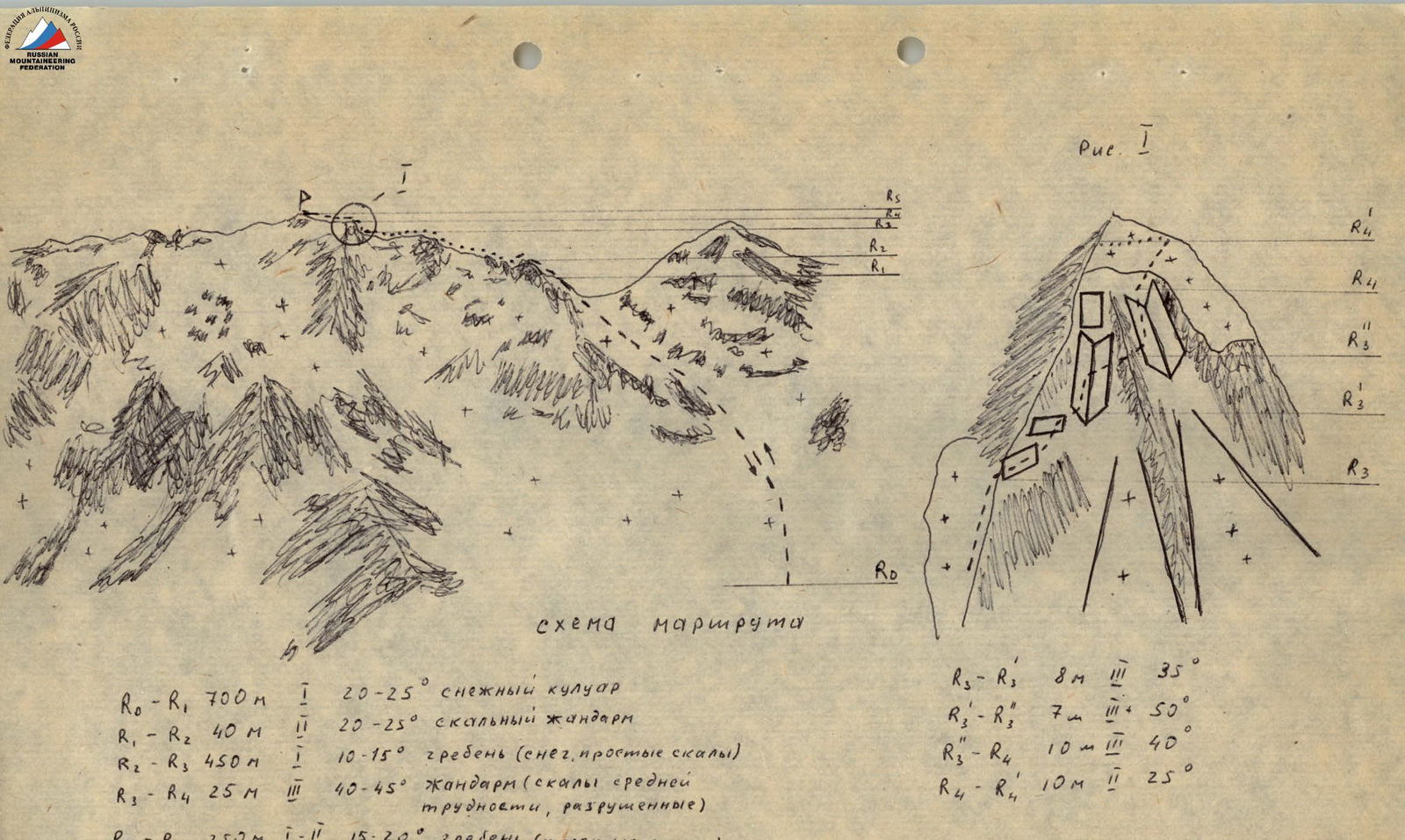
Fig. 1. Route diagram

| Section | Length | Category of difficulty | Steepness | Description |
|---|---|---|---|---|
| R0–R1 | 700 m | 1 | 20–25° | snow couloir |
| R1–R2 | 40 m | 2 | 20–25° | rocky guard |
| R2–R3 | 450 m | 10–15° | ridge (snow, easy rocks) | |
| R3–R4 | 25 m | 3 | 40–45° | guard (medium difficulty rocks, broken) |
| Details of the big guard: | ||||
| R3–R'3 | 8 m | 35° | ||
| R'3–R''3 | 7 m | 50° | ||
| R''3–R3 | 10 m | 40° | ||
| R4–R5 | 250 m | 1–2 | 15–20° | ridge (easy rocks) |
Fig. 2. Topographic map

Approach description
From the base camp, located near the bridge over the Vanch River, move down the road to the Ravak River. 1 hour walk. Ascend the Ravak gorge along the right (orographic) bank of the Ravak River. Then, via snow bridges and moraines, ascend to the snow plateau of the Ravak gorge cirque. Travel time: 5–6 hours.
Route description
Ascend a broad snow couloir to the saddle between Peak Kuli-Zod and Peak Maly Ravak. Steepness 20–25°; crampons are mandatory. The first guard is climbed directly, the rest are bypassed on the right. Simultaneous movement along a simple snow ridge and broken rocks with a steepness of 10–15° leads to the big guard (key section). It is climbed diagonally up to the right via ledges into an inner corner, then up to a small ridge and further into the second inner corner, then diagonally up to the right onto a snow slope. From the slope, ascend diagonally up to the left to the ridge behind the guard. The total length of this section is 25 m, steepness 45–50°. Rocks are of medium difficulty, very broken (difficult to organize belaying). After the big guard, move along the ridge on easy rocks with a steepness of 15–20° to the summit. Travel time from the start of the route: 5–6 hours. Descent is made via the ascent route.