- Climbing category: rock climbing
- Climbing area: Pamir, Vanch Range.
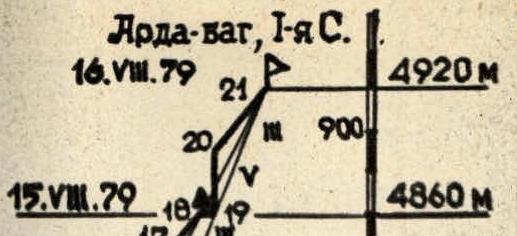
- Peak, its height, and climbing route: 1st North peak of Arda-bag (4920 m) via the West face.
- Proposed category of difficulty: 5B
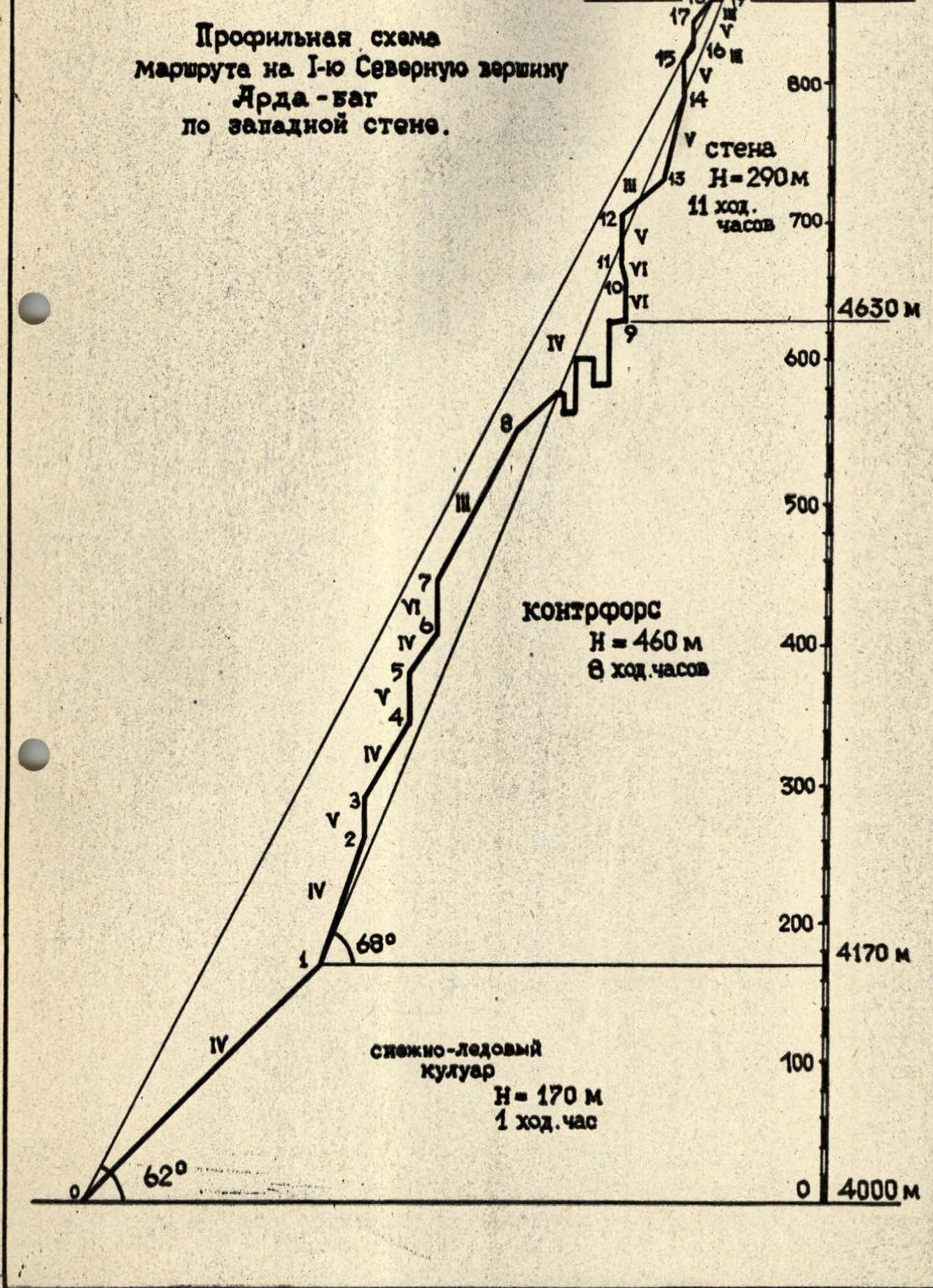
- Route characteristics: height difference — 920 m; average steepness — 68°; total length of sections — 1160 m, including R1 — none, R2 — none, R3 — 285, R4 — 510, R5 — 270, R6 — 95.
- Pitons hammered: for belaying — rock 67, ice 4; for aid climbing — 3; expansion bolts — none.
- Number of climbing hours: 20 hours.
- Number of bivouacs and their characteristics: 1 bivouac, sitting.
- Surname, name, patronymic of the team leader and participants, and their sports qualification: Nikolaichuk Oleg Leonidovich, Candidate Master of Sports, team leader; Onysko Orest Stepanovich, Candidate Master of Sports; Viter Igor Sergeevich, 1st sports category; Gusakovsky Viktor Vasilyevich, 1st sports category.
- Team coach: Bolizhevsky Valery Konstantinovich, Master of Sports of the USSR.
- Date of departure and return: from August 14 to August 17, 1979.
Brief description of the climbing area and approach routes
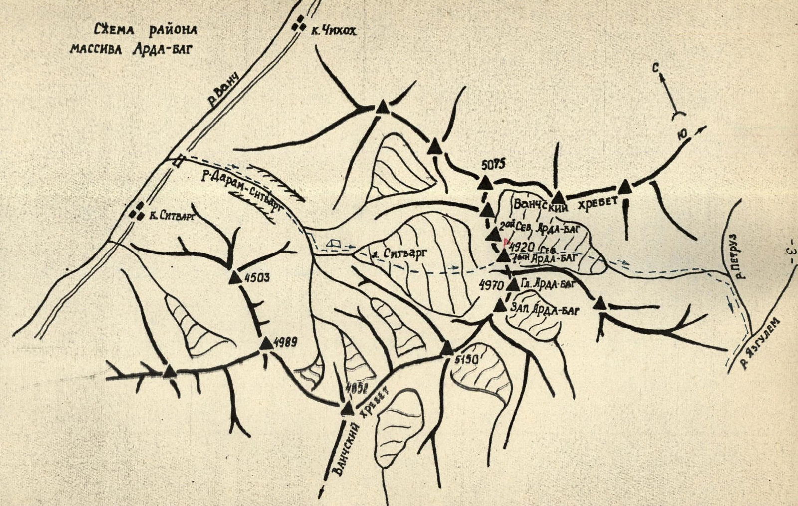
The Arda-bag massif, chosen for the climbing competition for the primacy of the Soviet Army and Navy in the rock climbing category, is located in the western part of the Vanch Range. The upper part of the massif is clearly visible from the highway in the Vanch valley between the villages of Sitvarg and Chikhakh. The approach starts from the bridge across the Daram-Sitvarg river on the left side of the valley.
Approach:
- Starts from the bridge across the Daram-Sitvarg river on the left side of the valley.
- Follow the trail, which is partially destroyed, for 2.5–3 hours to the first rock outcrop, where you need to cross to the right side.
- Cross the river by wading, on stones, or using a bridge.
- After 1–1.5 hours of walking on the right side, there is another outcrop.
- Here, cross to the left side by wading or on stones.
- Continue to the green couloir descending from the terrace and follow it to the campsite.
- Overnight here.
From the campsite, the entire Arda-bag massif is visible to the east. It stretches from north to south for approximately 5–6 km, without dropping below 4800 m. Small depressions between the peaks are 100–200 m. The massif sharply drops to 4000 m on the north and south, but there are no marked passes in this part of the Vanch Range.
- Not marked on the map.
- Locals are not aware.
To the west, the Arda-bag massif ends with a kilometer-high wall along its entire length. The entire wall is intersected horizontally by two characteristic black bands. These belts, as it turned out later, represent the most destroyed sections of the route.
The massif has five peaks with heights ranging from 4900 m to 5000 m:
- First (Main) peak
- Second North peak
- Third North peak
- Fourth North peak
- Fifth North peak
The wall between the second and third north peaks is divided by a giant internal angle. A steep ridge approaches the Main peak from the west, separated from the wall by snow and ice couloirs. The steepest part of the West face is located between the Main and 2nd North peaks.
The approach to the wall from the campsite takes 2.5–3 hours and follows the surface moraine of the Sitvarg glacier.
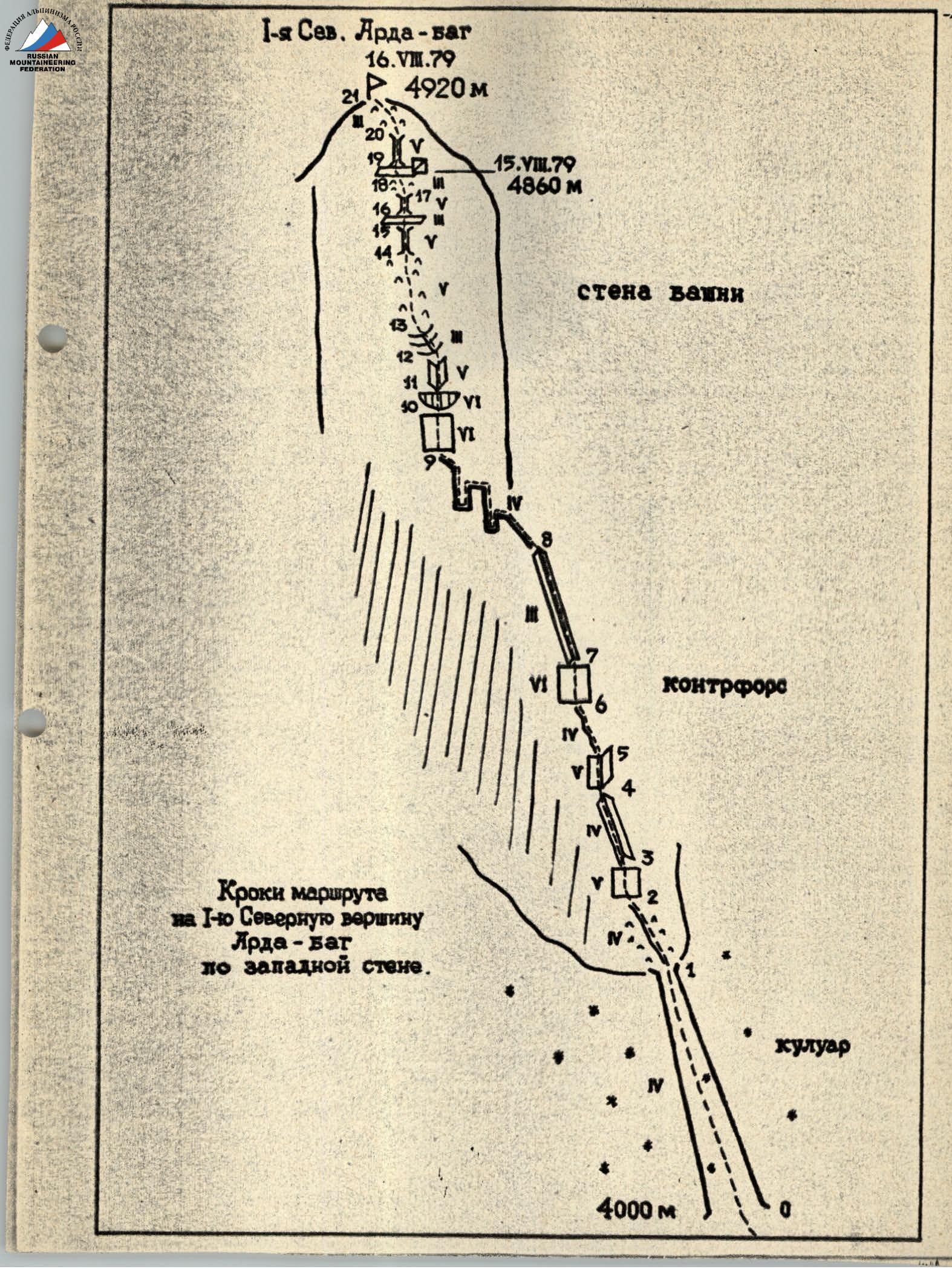 Profile diagram of the route to the 1st North peak of Arda-bag via the West face.
Explanations for the table of main characteristics
On August 15, 1979, the team reached the base of the couloir around 6:00 am after approaching via the surface moraine of the Sitvarg glacier. Here, they put on their harnesses, roped up, and began the ascent with belaying through an ice axe since the firn was very dense.
As they approached the rocks of the buttress, the firn turned into ice, and they had to organize belaying through screw pitons.
The teams moved in the following order: Nikolaichuk O.L., Onysko O., Gusakovsky V.V. — Viter I.S.
The exit to the buttress was to the right of the base of a small rock couloir on its right side. The couloir was considered dangerous due to rockfall.
They climbed very carefully through severely destroyed and steep rocks to the base of an overhanging wall that blocked the exit to the ridge of the buttress.
The first to pass the wall was O. Onysko, wearing crampons and without a backpack. The others climbed using jumar ascenders, lifting their backpacks using the "yosemite" method on a harness. This ascent required minimal energy expenditure and allowed them to move at maximum speed.
Further along the ridge of the buttress, bypassing an overhanging section to the right, they reached a vertical internal angle and followed it back to the ridge. Here, the lead climber's progress was significantly hindered by ice forming in the upper part of the angle from water flowing from small snowfields on the ridge in the second half of the day.
They approached the base of a white monolithic wall along the ridge. Bypassing it to the right or left was not considered possible due to the severe destruction and steepness of the section. They climbed the wall first to the right towards a small fracture, and then straight up to the ridge.
Belaying was complicated by a lack of cracks for pitons. Quickdraws made from nylon webbing were very helpful, as they could be attached to partially driven pitons. They also helped in pulling a single rope through a forest of pitons.
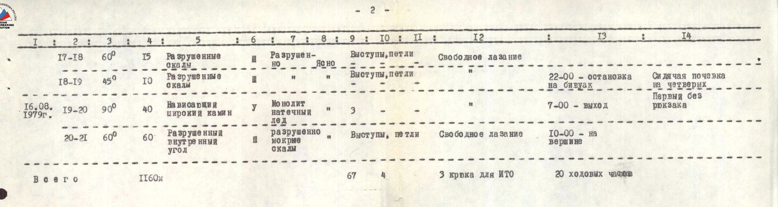
TABLE OF MAIN CHARACTERISTICS of the first ascent route to the 1st North peak of Arda-bag via the West face
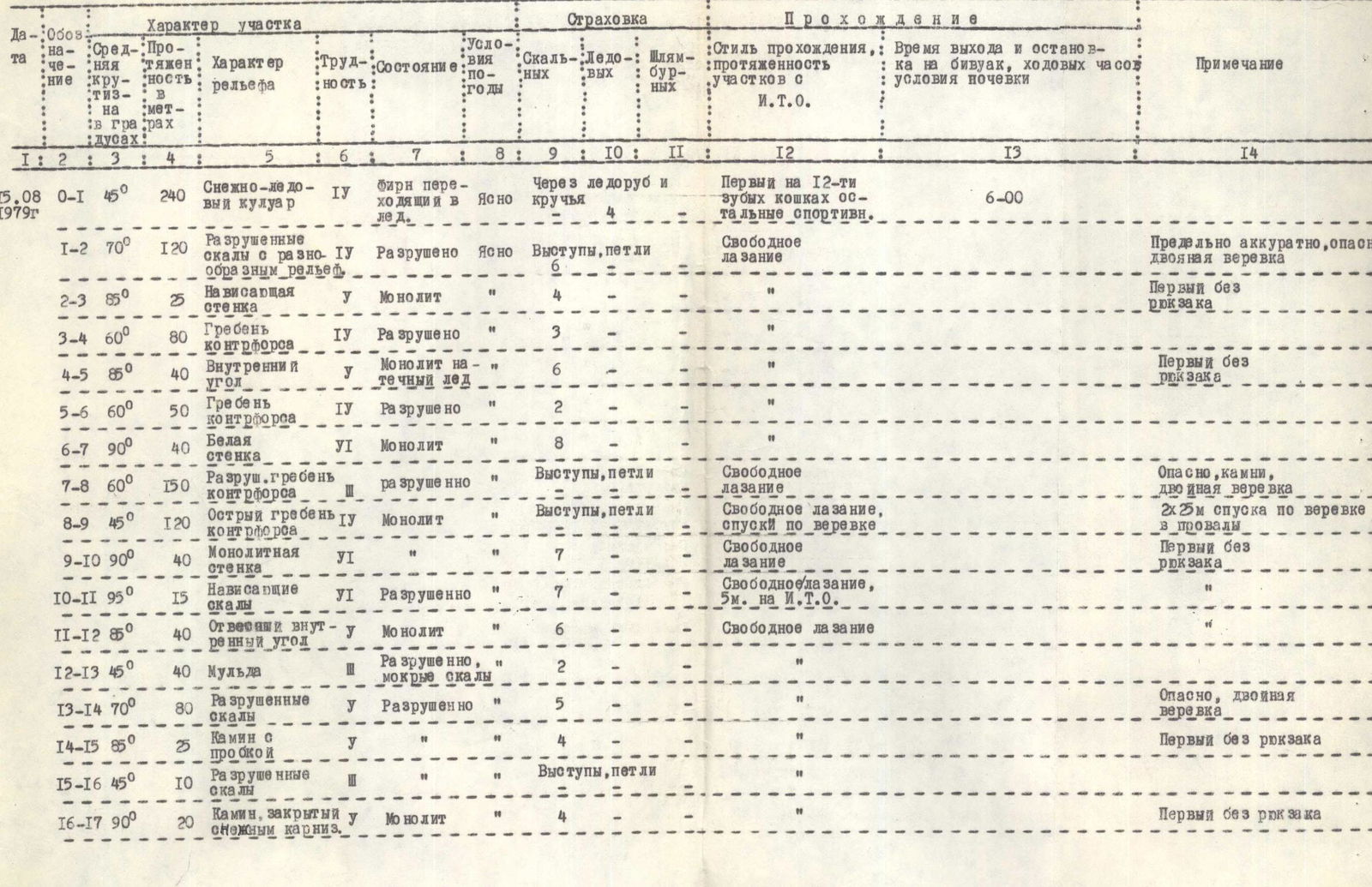
| Date | Section | Steepness | Length | Terrain characteristics | Diff. cat. | Condition | Weather | Rock pitons | Ice pitons | Expansion bolts | Aid climbing, length | Style of ascent | Time / Bivouac | Remarks |
|---|---|---|---|---|---|---|---|---|---|---|---|---|---|---|
| 15.08.1979 г. | R0–R1 | 45° | 240 м | Snow and ice couloir | 4 | Firn turning into ice | Clear | Through ice axe and screw pitons 4 | First on 12-tooth crampons, others sport climbing; free climbing | 6:00 | ||||
| R1–R2 | 70° | 120 м | Destroyed rocks with varied terrain | 4 | Destroyed | Clear | Protrusions, loops 6 | Free climbing | Very carefully, dangerous, double rope | |||||
| R2–R3 | 85° | 25 м | Overhanging wall | 5 | Monolithic | 4 | First without backpack | |||||||
| R3–R4 | 60° | 80 м | Ridge of buttress | 4 | Destroyed | 3 | ||||||||
| R4–R5 | 85° | 40 м | Internal angle | 5 | Monolithic, ice | 6 | First without backpack | |||||||
| R5–R6 | 60° | 50 м | Ridge of buttress | 4 | Destroyed | 2 | ||||||||
| R6–R7 | 90° | 40 м | White wall | 6 | Monolithic | 8 | ||||||||
| R7–R8 | 60° | 150 м | Destroyed ridge of buttress | 5 | Destroyed | Protrusions, loops | Free climbing | Dangerous, rocks, double rope | ||||||
| R8–R9 | 45° | 120 м | Sharp ridge of buttress | 5 | Monolithic | Protrusions, loops | Free climbing, rappelling | 2×25 m rappelling into hollows | ||||||
| R9–R10 | 90° | 40 м | Monolithic wall | 6 | Monolithic | 7 | Free climbing | First without backpack | ||||||
| R10–R11 | 95° | 15 м | Overhanging rocks | 6 | Destroyed | 7 | 5 м | Free climbing, 5 m aid climbing | ||||||
| R11–R12 | 50° | 40 м | Vertical internal angle | 5 | Monolithic | 6 | Free climbing | |||||||
| R12–R13 | 45° | 40 м | Mulde | Destroyed, wet rocks | 2 | |||||||||
| R13–R14 | 70° | 80 м | Destroyed rocks | 5 | Destroyed | 5 | Dangerous, double rope | |||||||
| R14–R15 | 85° | 25 м | Chimney with a plug | 5 | 4 | First without backpack | ||||||||
| R15–R16 | 45° | 10 м | Destroyed rocks | Protrusions, loops 6 | ||||||||||
| R16–R17 | 90° | 20 м | Chimney closed by a snow cornice | 5 | Monolithic | 4 | First without backpack | |||||||
| 16.08.1979 г. | R17–R18 | 60° | 15 м | Destroyed rocks | Destroyed | Clear | Protrusions, loops | Free climbing | ||||||
| R18–R19 | 45° | 10 м | Destroyed rocks | Protrusions, loops | 22:00 — stop for bivouac | Sitting bivouac for four, first without backpack | ||||||||
| R19–R20 | 90° | 40 м | Overhanging wide chimney | 5 | Monolithic, ice | 3 | 7:00 — departure | |||||||
| R20–R21 | 60° | 60 м | Destroyed internal angle | Destroyed, wet rocks | Protrusions, loops | Free climbing | 10:00 — on the summit | |||||||
| Total | 1160 м | 67 | 4 | 3 aid climbing pitons | 20 climbing hours |
Further along the ridge, they had to navigate a section of sharp ridge with hollows that led to the summit tower. The hollows were so steep that they had to organize two rappels. They did not attempt to bypass these sections due to the high risk of rockfall in both couloirs on the right and left.
Along the sharp ridge, they approached the wall of the tower:
- First, 10 m straight up;
- Then along an inclined crack to the right and up, exiting into a niche where two people could stand;
- From the niche, to the left through a cornice using ladders, to the base of an internal angle;
- Exit to a mulde via the internal angle.
The cornice and base of the internal angle, despite being very steep, were severely destroyed, so they moved using pre-fixed ropes and with top-rope belay. The first climber passed these sections on a double rope. They crossed the mulde from left to right, monitoring the top, as rocks periodically fell through it.
They climbed the steep, destroyed rocks of the tower wall to the base of a clearly visible chimney with a plug at the top. It was getting dark, and there was no suitable place for a bivouac.
They climbed the chimney and traversed to the right along a narrow ledge to the base of another chimney closed by a snow cornice. The upper part had ice. However, after the snow, there was a small platform where the first climber ascended in the dark. The others followed with headlamps. It was already 22:00. After preparing the platform for a bivouac, they quickly had dinner and went to sleep.
On August 16, 1979, they rose at 6:00. While the pair Nikolaichuk O. and Onysko O. prepared breakfast, Gusakovsky V. processed the last critical section. A wide and partially overhanging chimney led straight up. Its walls were covered in ice, which had to be chipped away with a hammer.
Finally, the rope was fixed at the exit from the chimney. Gusakovsky descended, and they all had breakfast before starting the ascent. Exiting the chimney, they entered a wide internal angle and climbed along its left side to the ridge, 10 m to the left of the summit.
At 10:00, they gathered on a small summit platform. They built a cairn, connected with observers, and began their descent to the east. They descended into the Petruz river valley and further along the Yazglem river valley to the Pyanj river, where their car was waiting.
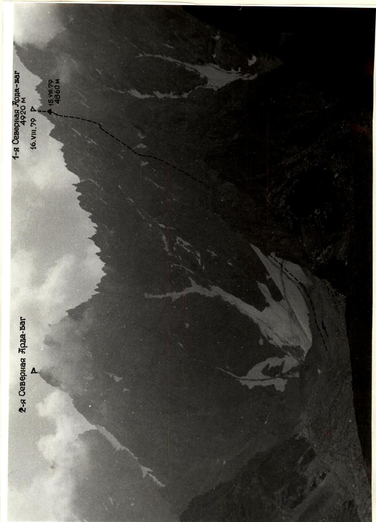
Photo 1. General view of the route.
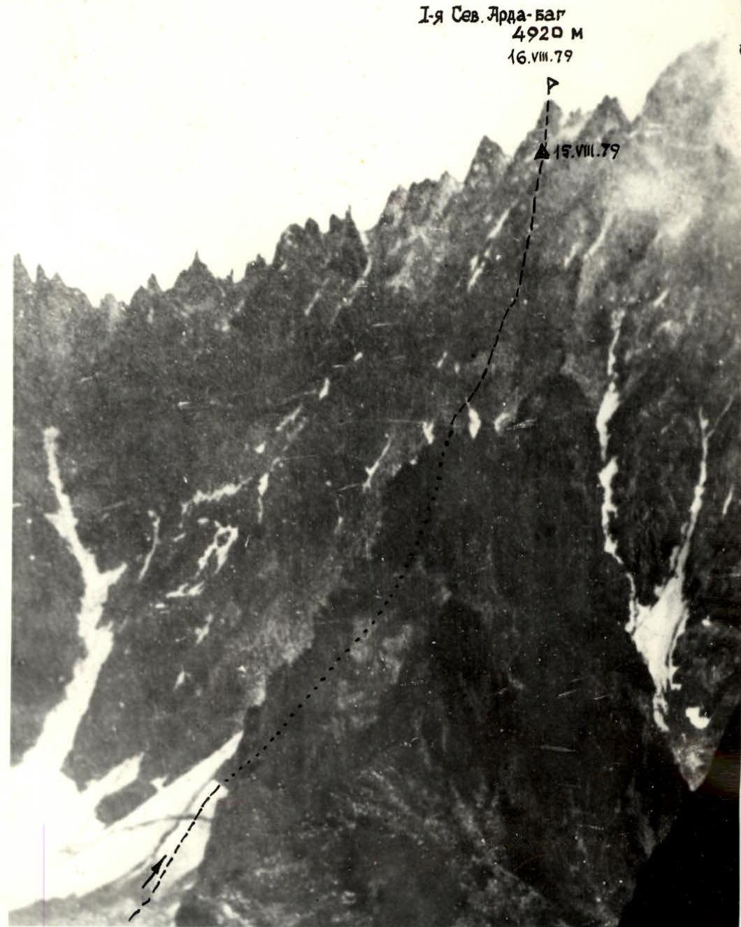
Photo 3. Semi-profile of the West face of the massif.