Ascent Passport
-
Ascent class: High-altitude technical
-
Ascent area: Pamir, Akademiya Nauk range
-
Peak, its height, route: Peak 6431, via NW wall (from Ayu-Jilga glacier)
-
Estimated difficulty category: 6B category of difficulty
-
Route characteristics:
Height difference:
- Rocky part of the route — 1850 m
- Snow-ice part of the route — 280 m
- Total height difference of the route — 2130 m
Steepness:
- Rocky part of the route — 72°
- Snow-ice part of the route — 42°
- Overall steepness of the route — 65°
Length:
- Rocky part of the route — 2215 m
- Snow-ice part of the route — 470 m
- Total length of the route — 2685 m
Length of sections:
- 1st category of difficulty — 90 m
- 2nd category of difficulty — absent
- 3rd category of difficulty — 290 m
- 4th category of difficulty — 995 m
- 5th category of difficulty — 845 m
- 6th category of difficulty — 465 m
-
Number of pitons hammered for protection: rock — 230 (including 11 for creating intermediate belay points); chocks — 53 (including 15 for creating intermediate belay points); ice screws — 12; bolt pitons — 0.
-
Number of climbing hours: 72.5 hours
-
Number of bivouacs on the route: 8 bivouacs. 6 bivouacs — lying down in tents. 2 bivouacs at camps 5400 and 5650 — semi-sitting in tents.
-
Full name of the leader, participants, their sports qualification:
- Kovtun Vasily Grigorievich — Master of Sports, Kiev, leader
- Bodnik Vitaly Nikolaevich — Master of Sports, Kiev, deputy leader
- Bychek Alexander Mikhailovich — Master of Sports, Kiev, participant
- Barsukov Valery Albertovich — Candidate Master of Sports, Kharkov, participant
- Bozhko Igor — Candidate Master of Sports, Kiev, participant
- Kharianyk Ivan Vasilyevich — Candidate Master of Sports, Kiev, participant
- Tsakanyan Oleg Semenovich — Candidate Master of Sports, Kharkov, participant
-
Team coach — Kovtun Vasily Grigorievich
-
Date of departure and return — July 16 – July 25, 1981
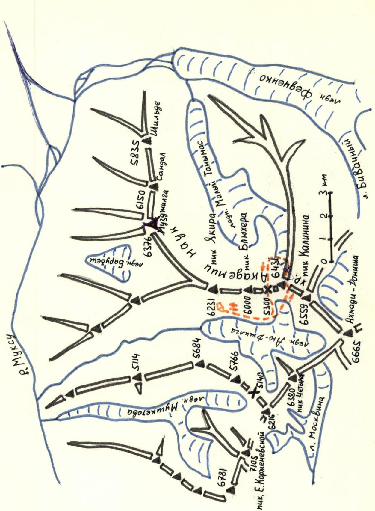
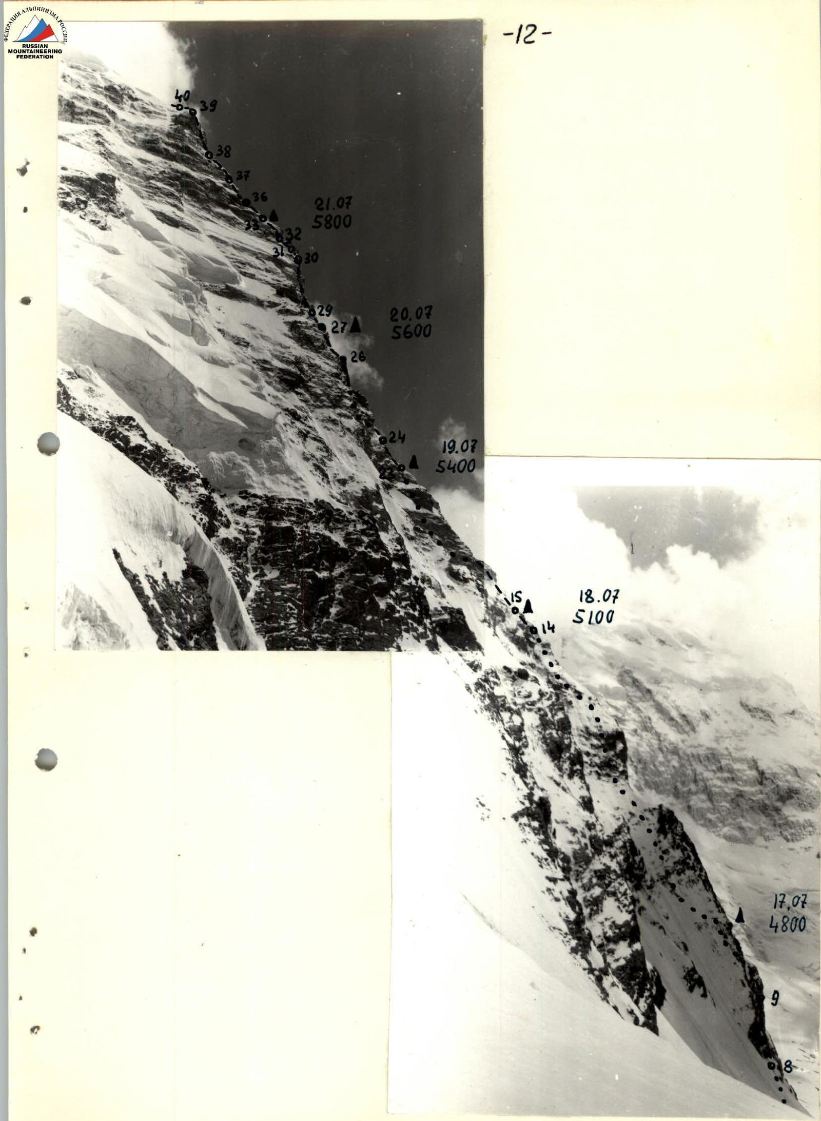
Map-scheme of the Ayu-Jilga glacier area
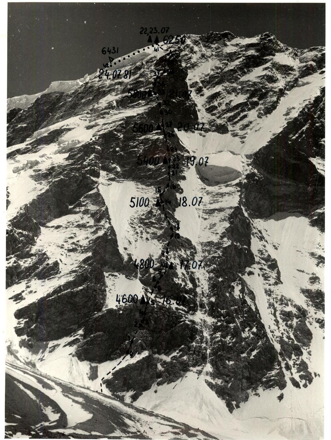
July 16, 1981
Approach along a snow ledge (250 m long, 40° steepness) to the wall.
Up an inner corner 60 m long, 75° steepness to the main shoulder (R0–R1).
From the shoulder, 120 m up the wall at 80° (R1–R2) to an inner corner (15 m long, 90°) (R2–R3).
Then 40 m up the wall at 95° — exit to a ledge (R3–R4). From the ledge, 60 m up the wall at 90° — exit to the top of the lower bastion (R4–R5).
(–295 m) Overnight stay (4600 m) (H – 300 m)
July 17, 1981
Up a snow-ice slope at 45° (pitons on rocky outcrops for protection) — 120 m (R5–R6) to the base of the large (right) rocky triangle.
Then 20 m up a sheer inner corner (R6–R7) of the left part of the triangle's wall under an overhanging rusty cornice.
The cornice is traversed on the left side for 5 m (95–100°) (R7–R8). Then straight up 40 m up the wall at 85–90°. Exit to the left edge of the triangle (R8–R9).
Up slabs at 60–70°, covered with ice, to the top of the triangle (70 m) (R9–R10).
(–255 m) Overnight stay (4800 m) (H – 200 m)
July 18, 1981
Up a rocky-snowy ridge (60 m, 45°) to the base of the first rocky ascent (R10–R11).
From here, right-up (100 m, 70°), exit to the right face of the first ascent (R11–R12).
Then 40 m up an inner corner (90°) (R12–R13). Along the ridge (140 m, 60°) to the base of the second rocky (rusty) ascent (R13–R14).
(–340 m) Overnight stay (5100 m) (H – 300 m)
Table of main characteristics of the ascent route to Peak 6431 from Ayu-Jilga glacier (via NW wall)
| Date | Designation | Average steepness in degrees | Length, meters | Terrain character | Difficulty | Condition of the section | Weather | Rock pitons | Chocks | Ice screws | Bolt pitons |
|---|---|---|---|---|---|---|---|---|---|---|---|
| July 16, 1981 | R0–R1 | 75 | 60 | Inner corner | 1 | Clean monolithic rocks | Good | 8 | – | – | – |
| R1–R2 | 80 | 120 | Wall | 5 | Rocks, partially iced | " | 17 | 10, 3 | – | – | |
| R2–R3 | 90 | 15 | Inner corner | 6 | Icy rocks | " | 4, 1 | 2 | – | – | |
| R3–R4 | 95 | 40 | Wall | 6 | Rocks, partially iced | " | 7, 2 | – | – | – | |
| R4–R5 | 90 | 60 | " | 6 | " | " | 9 | 2, 4 | – | – | |
| Departure at 6:00. Stop at 17:00. Climbing hours — 11. Overnight lying down. | |||||||||||
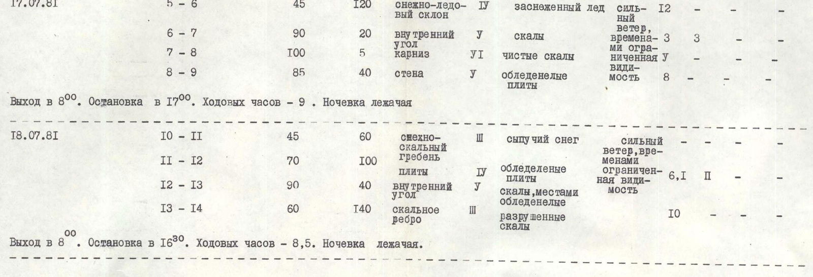
| July 17, 1981 | R5–R6 | 45 | 120 | Snow-ice slope | 4 | Snow-covered ice | Strong wind, occasional limited visibility | 12 | – | – | – |
| R6–R7 | 90 | 20 | Inner corner | 5 | Rocks | " | 3 | 3 | – | – | |
| R7–R8 | 100 | 5 | Cornice | 6 | Clean rocks | " | – | – | – | – | |
| R8–R9 | 85 | 40 | Wall | 5 | Icy slabs | " | 8 | – | – | – | |
| Departure at 8:00. Stop at 17:00. Climbing hours — 9. Overnight lying down. | |||||||||||
| July 18, 1981 | R10–R11 | 45 | 60 | Snow-rocky ridge | 3 | Loose snow | Strong wind, occasional limited visibility | – | – | – | – |
| R11–R12 | 70 | 100 | Slabs | 4 | Icy slabs | " | 6, 1 | 2 | – | – | |
| R12–R13 | 90 | 40 | Inner corner | 5 | Rocks, partially iced | " | – | – | – | – | |
| R13–R14 | 60 | 140 | Rocky ridge | 3 | Broken rocks | " | 10 | – | – | – | |
| Departure at 8:00. Stop at 16:30. Climbing hours — 8.5. Overnight lying down. |
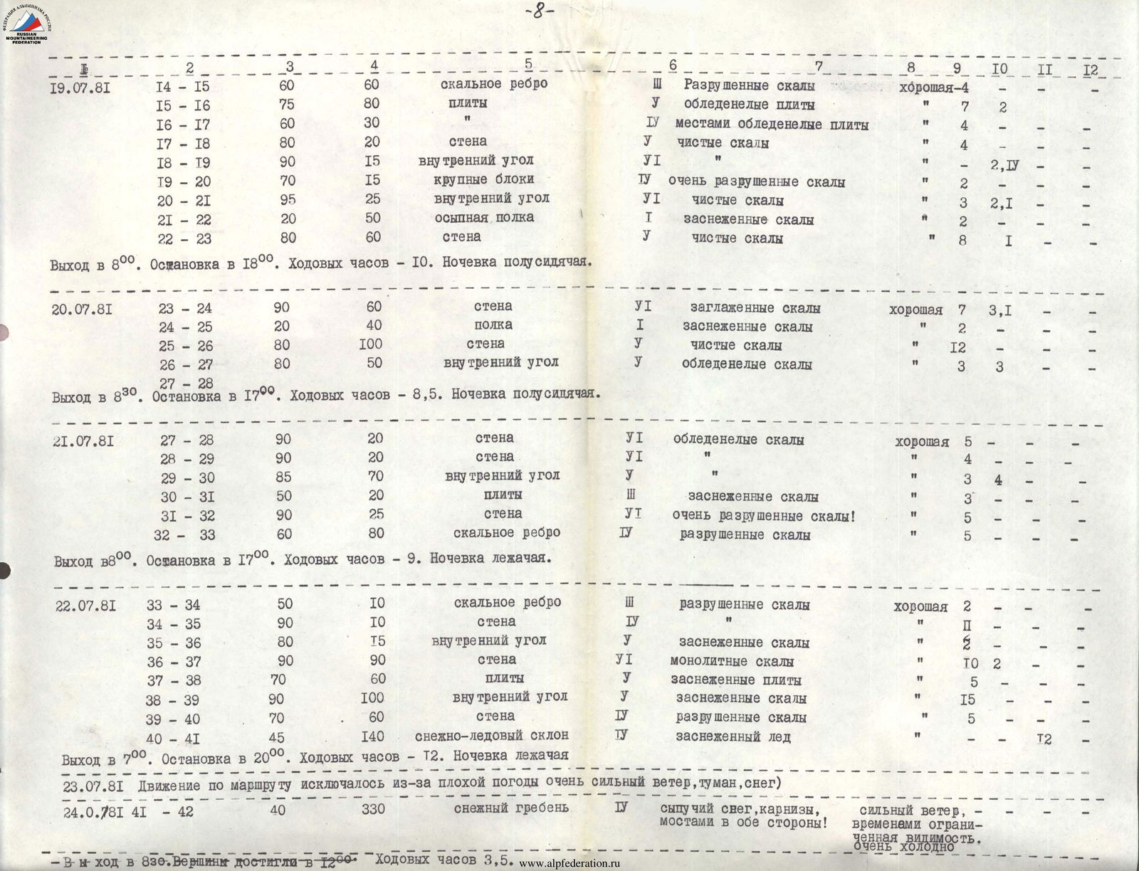
July 19, 1981
From the bivouac (60 m, 60°) along the ridge (R14–R15). Then up grey rocks at 75° straight up 80 m (R15–R16). Then right-up 30 m along grey slabs at 60° (R16–R17) to the base of a 20-meter wall (R17–R18), leading to a vertical rusty corner 15 m (R18–R19). Up this inner corner to under loose rusty rocks.
Up rusty rocks (15 m, 70°) (R19–R20) to the base of an overhanging wall 25 m, which is traversed along an inner corner (95°) (R20–R21).
Then the rocky ascent is bypassed on the right along a talus ledge (50 m, 20°) (R21–R22).
From here, 60 m up steep rocks (80°) to the shoulder of the rocky ridge (R22–R23). (–355 m) Overnight stay (5400 m) (H – 300 m)
July 20, 1981
From the bivouac up the wall (60 m, 90°) to a ledge (R23–R24). Along the ledge, traverse 40 m (R24–R25) to the base of a 100-meter rocky ascent (80°) (R25–R26), ending at a talus ledge.
From the ledge (50 m, 80°) up steep rocks (R26–R27) to a talus ridge at the base of a rocky bastion. (–250 m) Overnight stay (5600 m) (H – 200 m)
July 21, 1981
From the talus ridge 20 m up (very difficult climbing, 90°) (R27–R28) and 20 m left, difficult traverse (R28–R29) to the base of a wide inner corner.
Up it 70 m (R29–R30) to the top of the bastion.
Then up a steep rocky ascent to the second bastion 20 m, 50° (R30–R31), 25 m (wall), 90° (R31–R32), 80 m, 60° (R32–R33). (–235 m) Overnight stay 5800 m (H – 200 m)
July 22, 1981
From the bivouac 10 m (50°) (R33–R34) to under a 10-meter sheer wall (R34–R35).
The wall ends at a ledge, from which up an inner corner (15 m, 80°) (R35–R36), to the second rocky bastion.
The bastion is traversed along a sheer, partially overhanging, monolithic wall (90 m) (R36–R37), leading to a sloping ledge (70°, 60 m) (R37–R38), along which right-up to the base of an inner corner.
Up the inner corner (100 m, 90°) (R38–R39) to the left edge of the second bastion.
Then along the edge 60 m, 70° (R39–R40) to the top of the second bastion.
From the top of the bastion along a snow-ice slope (45–50°) (R40–R41), bypassing gendarmes, to the main ridge.
(–485 m) Overnight stay 6250 m (H – 450 m)
July 23, 1981
Bad weather, movement impossible.
July 24, 1981
From the bivouac along the snowy ridge with cornices (200 m) and then along snowy fields at 35–40° to the summit (R41–R42).
Descent to Maly Tanymas glacier.
Corner 4–5

Corner 0–1
Corner 36–37

Footnotes
-
— 3rd entry to the summit. Reached the summit at 12:00. ↩