
Ascent
to Peak 5585 via the northern edge from the Maly Tanymas Valley (Central Pamir, Mazarskiye Alps)
Expedition of the Odessa Regional Council DSO "Avangard"
Ascent leader — Staritsky P. I. 2. Vlasenko A. 3. Orobei I. 4. Eremenkov. 5. Novoselov E. 6. Kolomeytseva V. 7. Ingridenko A.
Odessa, 1969
General characteristics of the route
Reconnaissance.
Peak 5585 is located in the right (orographically) ridge bordering the Maly Tanymas Glacier. A broad snow-ice ridge with powerful cornices, deep crevasses, and unexpected breaks runs north from the summit directly to the Maly Tanymas Glacier.
Given its proximity to the "3500 m" base camp, Peak 5585 can be considered the most convenient training site and panoramic viewpoint for reviewing routes to the Shilbe, Sandal, and Muzdжилга peaks.
During reconnaissance trips to the areas of Muzdжилга and Sandal peaks, the northern edge of Peak 5585 was thoroughly examined, and a preliminary ascent plan was outlined.
Considering the cornices and crevasses on the ridge, as well as the variable weather, the ascent to the summit was planned along the right side of the ridge, adhering to the edge of ice and rocks.
The group did not have any information about the peak, so the ascent was planned as a multi-day endeavor, and due to the snow-ice nature of the route, with early ("Caucasian") departures.
Ascent description
Day I
Departure from the 3500 base camp at 15:30. Along the right side, in a pocket between the slope and moraine, to the second lateral valley. Ascent up the stream to the terminal moraine of a small glacier on the northern slope of Peak Cherepanov. Bivouac.
Travel time 3 hours.
Day II
At 6:00, ascent from the bivouac to the ridge along a loose couloir descending from a gap in the northern ridge of Peak Cherepanov. Terrain characteristics — loose, broken rocks, small scree, snow, ice patches. Path to the saddle — 2 hours (600–700 m). Steepness 30–45°. (Section R0–R1).
Section R1–R2 from the saddle along steep scree slopes covered with a thin layer of snow. Simultaneous movement in the direction of the snow slope of the northern ridge of Peak Cherepanov. Along the slope (steepness 40°) until ice appears under the snow.
Travel time 4 hours.
Section R2–R3. Steep ice slope 45–50°, length 400 m.
- Alternating movement
- Step cutting
- Crampons
- Piton belay
General direction to the right towards the edge of rocks. In a pocket of the ridge, on the boundary of rocks and ice, bivouac.
Day III
At the bivouac site, tents are left behind; warm clothing and food are taken. Departure at 5:30.
Section R3–R4. Ice ascent, steepness 50–55°, length 200 m. Alternating movement.
Section R4–R5. Further path along the ridge is blocked by an ice wall, which is bypassed via rocks, descending into a wide couloir to the right of the ridge. The couloir is icy with rock outcrops. Steepness 55°. Step cutting. Piton belay into rocks and ice, through rock outcrops. Length 300 m.
Ascent to the pre-summit ridge. Section R5–R6. Pre-summit ridge with numerous deep crevasses, ice sections — smooth ice. Movement along the edge of ice and rocks. Length 300 m.
Average steepness 30°. Section R6–R7. Summit section. Directly before the summit dome, the path is blocked by a rocky gendarme, which is bypassed from left to right (difficult climbing along the edge of ice and rocks, steepness 70°) followed by an ascent onto the flattening snow slope of the summit ridge — the dome.
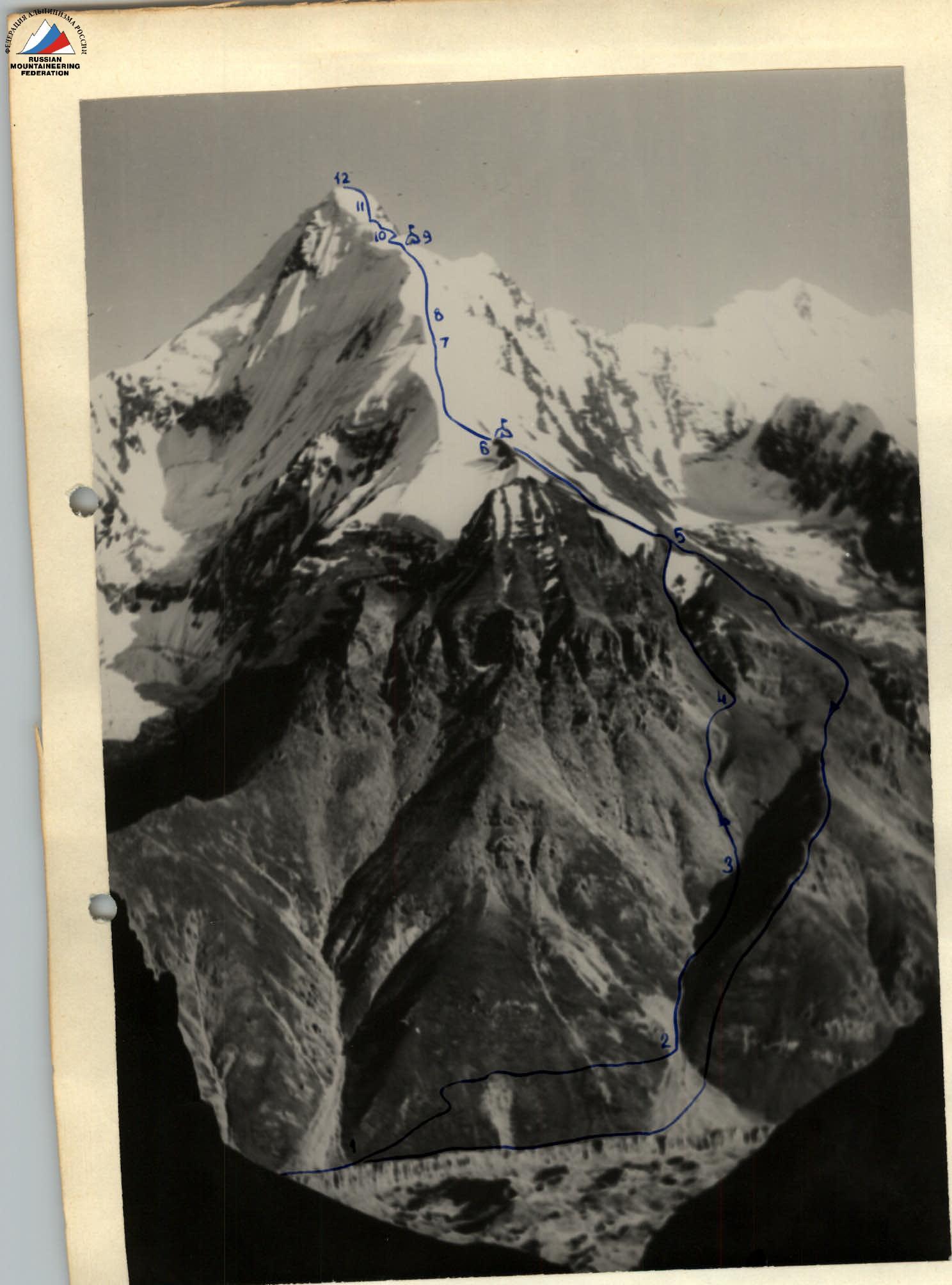
View of the peak from the north.