Kazakh Republican Council of the Spartak Voluntary Sports Society
Report
on the ascent of Peak "5570" via the NE wall.
Alma-Ata 1972
From July 28 to August 2, 1972, a group from the Kazakh Republican Council of the Spartak Voluntary Sports Society consisting of:
-
- G. A. Petrashko — Master of Sports, leader
-
- G. A. Beloborodov — Candidate for Master of Sports, participant
-
- V. P. Parfenov — Candidate for Master of Sports
-
- Yu. V. Rozin — Master of Sports
-
- M. V. Sorokin — Candidate for Master of Sports
-
- A. D. Toporkov — Master of Sports
made a first ascent of Peak "5570", located in a lateral ridge of the Academy of Sciences Range. The group dedicated the ascent to the memory of their comrade and friend E. K. Kombarov.
Peak "5570"
Currently, there is no need for detailed descriptions of well-known routes from Osh to the Fedchenko Glacier. The intricacies of helicopter, automobile, and other forms of transport have long been known. Any mountaineer of any qualification can tell you in detail how to get to Altyn-Mazar and then to the Fedchenko Glacier. When transitioning from the Fedchenko Glacier to the Bivachny Glacier (one must definitely go on foot; flying by helicopter, you won't notice anything), a beautiful peak is visible on the right, with its NE wall dropping down to the Kalinin Glacier. The further you advance towards the upper reaches of the Bivachny Glacier, the more Peak "5570" gets lost among the surrounding giants. Apparently, for this reason, and also because the goal of expeditions in this area is usually Peak Communism or, at the very least, some six-thousander, Peak "5570" has remained unnoticed until now.
Peak "5570" is the last summit in the ridge that branches off from the Academy of Sciences Range near Peak Kalinin. The same ridge is home to:
- Peak Red Army (6330 m)
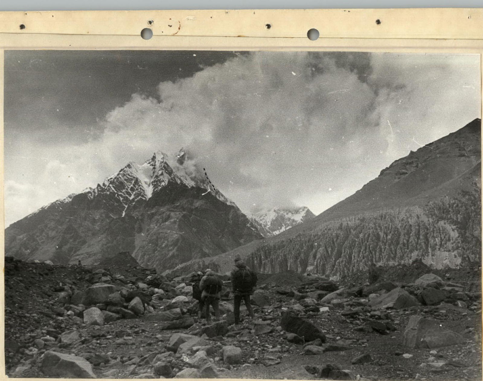 Photo 1. View of Peak 5570 from the Fedchenko Glacier.
an unnamed summit.
The ridge separates:
- the Kalinin Glacier
- the Bivachny Glacier
And in the upper reaches —
- the Kalinin Glacier
- the Odinnadtsati Glacier (Eleven Glacier)
A number of unnamed glaciers flow into these glaciers from the southern and northern sides of the ridge.
The snow-firn coverage boundary:
- on the southern side — around 5000 m
- on the northern side — at 4000 m.
Reconnaissance of the route
For the first time, the NE wall of Peak "5570" was viewed through binoculars from the point where the Bivachny Glacier flows into the Fedchenko Glacier. After setting up a base camp opposite the confluence of the Kalinin Glacier and the Bivachny Glacier, the expedition members made an exit onto the Kalinin Glacier to closely examine the NE wall of Peak "5570". This exit allowed them to understand the nature of the wall and largely correctly choose the necessary equipment.
The group left the base camp on July 26 and, according to the plan, observed the wall's behavior, its features in the second half of the day on July 26 and the whole day on July 27. Based on these observations, some details of the route were clarified.
Conditions for the ascent of Peak "5570"
Peak "5570" is located in a well-developed area for mountaineers in the Northwest Pamir. From the base camp on the Bivachny Glacier, one can reach the foot of the peak with a load in 3–4 hours.
The height of the summit allows:
- to work with acclimatization gained during the organization of the base camp;
- to conduct long-term work at heights above 5000 m, which allows for sufficient acclimatization for high-altitude ascents.
The weather conditions in this area are good. The peak is surrounded by high summits from the west and south, which shield it from strong southwest winds.
At night during the ascent, the temperature did not drop below 2–3 degrees of frost, making it possible to lighten the backpacks.
During the day, it is usually:
- warm
- windless.
Description of the route via the NE wall of Peak 5570
From the base camp on the right moraine of the Bivachny Glacier, we cross the glacier in the direction of the Kalinin Glacier. We navigate through the scree, bypassing the heavily crevassed Kalinin Glacier from the right (as seen from below) (photo 9). After 3–4 hours, we reach a large field. From this point, the upper reaches of the Kalinin Glacier and the NE wall of Peak "5570" are clearly visible (photo 2). The glacier above has a calm flow, and it can be crossed at any point. We set up camp on the shore of a small glacial lake. The camp's altitude is 4200 m.
Section R0–R1
About 30 meters above the camp, we cross the Kalinin Glacier. The glacier is flat and presents no difficulties.
Along the avalanche cone:
- We cross the bergschrund
- We reach the base of a large rocky outcrop (photo 3)
The height gain on this section is 50 m. Movement is simultaneous, with belaying through an ice axe.
Section R1–R2
The large rocky outcrop is bypassed from the left. Dense snow allows for reliable belaying through an ice axe. If necessary, belaying can be organized using rock pitons (photo 4). At the end of the section, ice is encountered in some places. The length of the section is 200–220 m, with a slope of 45°–50°. The height gain is 150 m.
Section R2–R3
Along gentle rocks at the end of the rocky outcrop, we move up to the right towards the ridge. The rocks are simple, but water flows complicate the movement. Belaying is through outcrops, with simultaneous movement. The length of the section is 100–120 m, with a slope of 45°–50°. The height gain is 70 m.
Section R3–R4
The rocks lead us to the ridge. The ridge is sometimes wide, sometimes very narrow. The average slope is 45°–50°, sometimes reaching 60°. In some places, solid firn appears, but generally, the movement is through deep snow with variable belaying through an ice axe (photo 5). The length of the section is 100–120 m. The height gain is 70 m.
Section R4–R5
The slope of the snowy ridge increases. Rocky outcrops appear, becoming more frequent. The rocks are destroyed, and some are filled with ice. Rock steps of 2–3 m do not present serious difficulties. Belaying is through outcrops and rock pitons. The length of the section is 80–100 m, with an overall slope of 50°–60°. The height gain is 60 m. 4 rock pitons were hammered.
In the middle of the section, there is a small platform that, after considerable effort, becomes our first overnight stop (Photos 6, 7).
Over 7 hours of work, we gained 400 m in height. The sections are generally simple. Movement is mostly simultaneous. 4 rock pitons were hammered.
Second day
Section R5–R6
Staying on the left side, we continue moving along the ridge. Destroyed rocks lead us to a gentle rocky ridge with small snow drifts. Belaying is through outcrops and rock pitons.
- Ridge length: 50–60 m
- Height gain: 15 m
- 3 rock pitons were hammered on this section
Section R6–R7
At the end of the ridge, there is a steep ascent. The upper part transitions into an ice-firn slope with a slope of 55°–60° over 40 m. Then, there is another steep ridge where we have to cut steps (photo 8). We deviate from the ridge to the right by 10 m to a large rocky outcrop. Here, we can organize belaying through rock pitons. There is not enough space for the entire group. Further, there is a very steep ice-firn slope with rare rock outcrops. The slope reaches 70°. This section is very complex. The height gain is 60 m. The average slope is 55°–60°, with the last 10 m reaching 70°. 2 ice pitons and 8 rock pitons were hammered.
Section R7–R8
Then, the path goes along an ice-firn slope, the steepness of which varies from 45° to 50°. In some places, we have to cut steps, which slows down the group's movement. Belaying is through an ice axe and ice pitons, with the overall length of the section being 160–180 m. The height gain is 100 m. 3 ice pitons were hammered.
At the end of the section, before a rocky tower in the ridge, we can cut out a platform. Here, we spent the second night.
Over 8 hours of work on the second day:
- We covered 290 m.
- Gained 175 m in height.
- Hammered 11 rock pitons and 5 ice pitons.
Third day
Section R8–R9
Immediately after the overnight stop, we begin working on the rocks of the lower bastion. We ascend 40 m along difficult rocks. On a small ledge, we can organize belaying. Here, we left a control cairn. Further, along sheer large-block rocks to an inclined ledge that goes up to the right. It is very difficult. The last 30 m are pulled up with ropes.
- The steepness of the rocks is from 60° to 70°
- Height gain is 100 m
- 15 rock pitons were hammered
Section R9–R10
Along the inclined ledge to the right and up. At the beginning of the ledge, there is a large snow drift. One must move with great caution. After 40 m, we approach a counterfort, behind which a wide couloir is located. The height gain is 20 m. 4 rock pitons were hammered.
Section R10–R11
Straight up along the counterfort for 40 m. The steepness of the rocks is 65°–70°. Many "live rocks" greatly complicate the climb. On a platform before steep marbleized limestone slabs, two people can rest. Despite the difficult section, we have to move with backpacks.
Rock pitons on the section:
- 8 rock pitons were hammered.
Further ascent up the rocks of the bastion is very complicated. The steep (up to 70°) slabs are made of marbleized limestone that layers and crumbles easily under hands (photo 9). It is very difficult to organize reliable belaying. In this regard, the group decided to traverse the slabs and couloir and exit to the right part of the wall to the base of the rocks of the second bastion.
Section R11–R12
Traverse to the right along the slabs. Climbing is very difficult. The rocks are so "soft" that sometimes a kick with a foot can create a foothold. There are few cracks for pitons. The section is very complex, and some pitons are not removed. The last one passes through the peripherals, and the rope holds. A platform where 2–3 people can stand is located behind the slabs near the couloir. The length of the section is 50 m. 16 rock pitons were hammered.
Section R12–R13
Up the couloir for 15 m. The rocks are steep, monolithic. Further, traverse to the right for 20 m. The length of the section is 35–40 m. The height gain is 15 m. The average steepness of the rocks is 60°–65%. 5 rock pitons were hammered. If viewed from section R11–R12, it seems that there should be a platform in this place. However, it is just a small section with less steep rocks. Up close, there is nothing better. The time is already 18:00. So, we decide to stop here. While one pair processes the further path, the others prepare for the night. On two small inclined ledges, we spend the night.
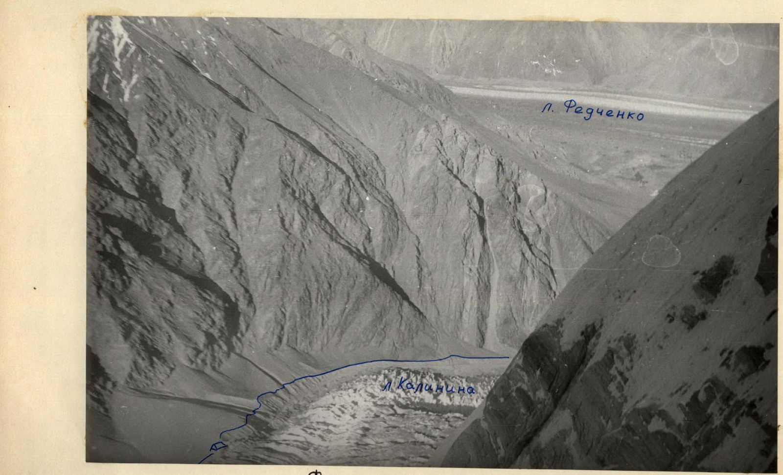 Photo 2. Rocks above section R11–R12. Below is the Kalinin Glacier, Fedchenko Glacier.
Over 9 hours of work, we covered 260 m. Gained 175 m in height. 48 rock pitons were hammered.
Fourth day
Section R13–R14
From the overnight spot to the right and up (photo 10), and then up parallel to the couloir. The rocks are very difficult. We have to hammer pitons for support. At the end of the section, there is a small overhang, but we can hammer pitons, hang ladders, and pass 2–3 m. The first person goes without a backpack. Before the overhang, there is a spot on the rocks for the second person, which significantly eases the work. After the overhang, there are several meters of formed ice and further along a small inner corner to a scree ledge. Here, everyone can gather. The lower half is sheer, the upper is 50°–55°. The height gain is 80 m. 20 pitons were hammered. One of the most complex sections of the route. Work on it took the group 4.5 hours.
Section R14–R15
We cross a small couloir and, under the base of the wall, move 20 m to the right, and then 60 m up along an ice-firn slope. To the left remain the rocks of the upper bastion, to the right — a ridge with large snow drifts. Belaying is through rock and ice pitons, sometimes through an ice axe. The steepness is 45°–55°. The height gain is 70 m. 2 ice pitons and 3 rock pitons were hammered.
Section R15–R16
We exit onto a counterfort made of schist. Belaying is through rock pitons. In the upper part, the counterfort transitions into an ice slope with embedded stones (photos 11, 12). Some rocky outcrops appear. We reach the ridge. The steepness of the section is from 45° to 60°. The length is 180 m. The height gain is 130–140 m. 9 rock pitons and 2 ice pitons were hammered.
There is no convenient spot for an overnight stay on the ridge, so we descend 40 m down and, under a large drift to the right on the ridge, cut out a platform.
Over 8 hours of work on the fourth day, we gained 290 m in height. 32 rock pitons and 4 ice pitons were hammered.
Fifth day
Section R16–R17
Along the ridge to the left and then down an ice slope to the base of a rocky belt. We have to cut steps. Some rock outcrops appear. The difficulty is medium, but it takes a lot of time. The length of the section is 100 m. The steepness is 45°–50°. The height gain is 70 m. 2 ice pitons and 10 rock pitons were hammered.
Section R17–R18
Traverse to the right with a slight height gain. We move along a strongly inclined rocky, and then ice ledge in the direction of a large gray rock. Under the base of the rock, there are several stones embedded in the ice. By cutting a platform in the ice, we can accommodate several people. Further, there is a horizontal traverse of 40 m along slabs made of tile-like rocks. The slope steepness is 65°–70%. The rock structure is fine-grained. When hammering pitons, the blocks flake off at the last moment. Organizing belaying requires a lot of patience and perseverance. We continue the traverse for 20 m along complex rocks. After a narrow couloir, we descend 2–3 m down and traverse again along a small ledge to a steep, heavily snowed-in rocky ridge. The spot is very complex. Pitons go in poorly. There are many cracks, but they are shallow, and the rocks flake off. Organizing reliable belaying requires significant effort. The length of the section is 100–110 m. 32 rock pitons and 2 ice pitons were hammered. The section is very complex, especially in the middle part.
Section R18–R19
Up the ridge, first along rocks for 40 m, and then along ice formed on the rocks. The ice on the ridge is covered with a thick layer (up to 1.5 m) of snow that needs to be cleared. Under the snow, the ice has a "lace-like" structure. Several kicks with a foot can create a step.
The ridge is steep, and we have to make handholds. For belaying, we move away from the ridge to the right, where we can hammer ice pitons. After 60 m, we reach two large rock outcrops. Here, everyone can be accommodated. The first person goes up along the icy ridge. The ridge is steep, and we have to cut steps to the left and right of the ridge. Ahead, a large snow drift is visible where we can make a platform. However, it's already dark, and, not reaching 20 m to the drift, we have to descend to rocky outcrops and, cutting a ledge in the ice, spend the night.
In total, on the section up to the overnight stop, 6 rock pitons and 5 ice pitons were hammered. After the overnight stop, up to the snow drift, another 6 ice pitons were hammered. The steepness is 60°–65°. The height gain is 140 m.
In total, over 10 hours of work on the fifth day, we gained 170 m in height. 48 rock pitons and 16 ice pitons were hammered. Sections R17–R18 and R18–R19 took a lot of effort, where very complex rock and ice work was performed.
Sixth day
The overnight stop has a northern exposure. The sun is hidden by a small ridge in the morning. We leave early. Everyone has a strong desire to finish the route. We quickly cover the processed section.
Section R19–R20
The icy ridge leads to a large snow drift. We ascend to the top of the drift and move 20 m towards the saddle (photo 13). The length of the section is 40 m. The steepness is 30°–45°. The height gain is 30 m. Belaying is through an ice axe.
Section R20–R21
The last 40 m before the ridge turned out to be very complex. The ridge is initially gentle, then becomes very steep again. We have to clear a thick layer of snow again. For 15 m, the first person digs a trench to their height. The ridge leads to a belt of rocks 3 m high, with a steepness of 65°–70°. The rocks are filled with ice and are completely smooth. There are no cracks. We have to deviate 5 m to the right, where we can hammer ice pitons and exit to the top of the slope. There are 6 m of pure formed ice left to the ridge. In the upper part, there is a three-meter section with a steepness of 75°–80°. In the lower part of the ice wall, we managed to hammer ice pitons. When attempting to exit to the ridge, the first person is thrown back. It's not possible to hammer a piton because one hand is occupied. We had to cut part of the ridge and only then exit onto it. The last 10 m of very complex ice work took 2 hours. 5 ice pitons were hammered on this section. The entire group reached the ridge at 13:00.
Section R21–R22
The group reached the ridge between two summits (photo 14). The western summit is 50 m higher than the eastern one. The summit is accessible via a ridge with cornices to the right.
- Length: 200 m
- Height gain: 70 m
- Belaying: through an ice axe
A note was left on the saddle on a large stone. The cairn is clearly visible.
Over 6 hours, we covered 270 m. Gained 170 m in height. 5 ice pitons were hammered. A very complex section, R20–R21, was passed.
The descent route does not present particular difficulties. First, along the ridge through the eastern summit, and then to the right along firn fields to an unnamed glacier. The upper reaches of the glacier are heavily crevassed. There are many hidden crevasses. Here and further down to the middle of the glacier, it's advisable to stick to the left side. Below the second step of the icefall, we cross the glacier almost to the middle and then straight down. In the lower, steep part of the icefall, there are many calgaspars that can be used to hang a rope for descent. The last lower step of the icefall is bypassed from the left. Further, along a narrow gorge, we exit onto the Bivachny Glacier.
The descent to the Bivachny Glacier takes 4–5 hours.
The NE wall of Peak 5570, with a height difference of approximately 1370 m, was climbed by the group in 48 hours of work with five overnight stops. Two overnight stops were sitting, one on a rocky, and two on snow-ice platforms. During the movement, 141 rock pitons and 29 ice pitons were hammered for belaying and artificial footholds. Sections R8–R9, R11–R12, R13–R14, R17–R18, R18–R19, and R20–R21 were particularly difficult. Most of the difficult sections are located in the upper part of the wall. The route is combined, with complex rock and ice sections. The group members have experience climbing peaks of 5B category difficulty:
- 10-3 Talgar (Snesarev's path)
- 6th Tower of the Crown
- Soviet Kyrgyzstan
- Trud
- Free Korea
- Karapolsky Peak
The group believes that the route they have taken can be rated as 5B category difficulty.
As the first ascenders, the participants request that the summit with the mark 5570 m be named "Spartak".

Characteristics of the sections
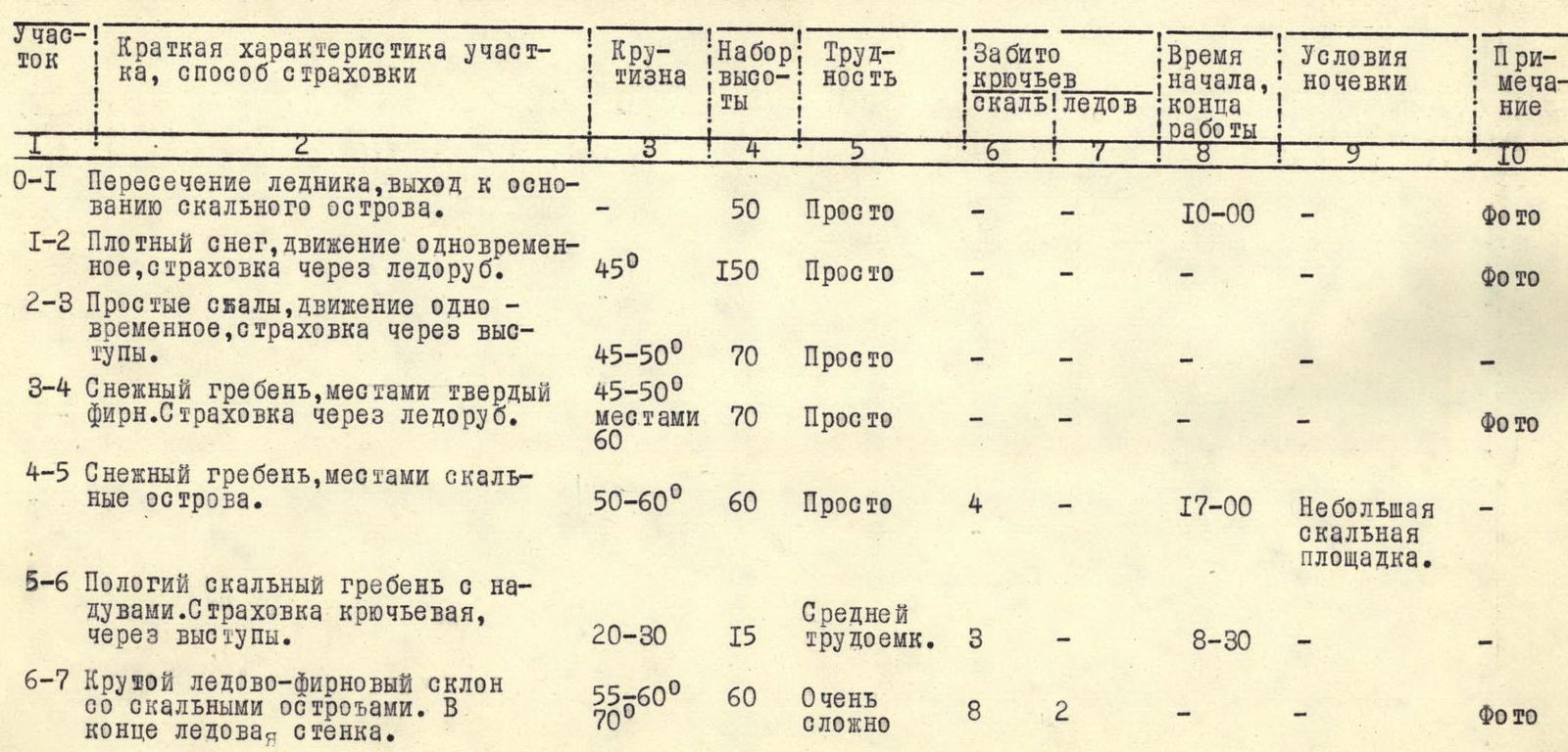
| Section | Brief characteristic of the section, belay method | Steepness | Height gain | Difficulty | Pitons (rock) | Pitons (ice) | Time (start / end of work) | Overnight conditions | Note |
|---|---|---|---|---|---|---|---|---|---|
| R0–R1 | Crossing the glacier, reaching the base of the rocky outcrop. | — | 50 m | Easy | — | — | 10:00 | — | (photo) |
| R1–R2 | Dense snow, simultaneous movement, belaying through an ice axe. | 45° | 150 m | Easy | — | — | — | — | (photo) |
| R2–R3 | Simple rocks, simultaneous movement, belaying through outcrops. | 45°–50° | 70 m | Easy | — | — | — | — | — |
| R3–R4 | Snowy ridge, sometimes firm snow. Belaying through an ice axe. | 45°–50°, sometimes up to 60° | 70 m | Easy | — | — | — | — | (photo) |
| R4–R5 | Snowy ridge, sometimes rocky outcrops. | 50°–60° | 60 m | Easy | 4 | — | 17:00 | Small rocky platform. | — |
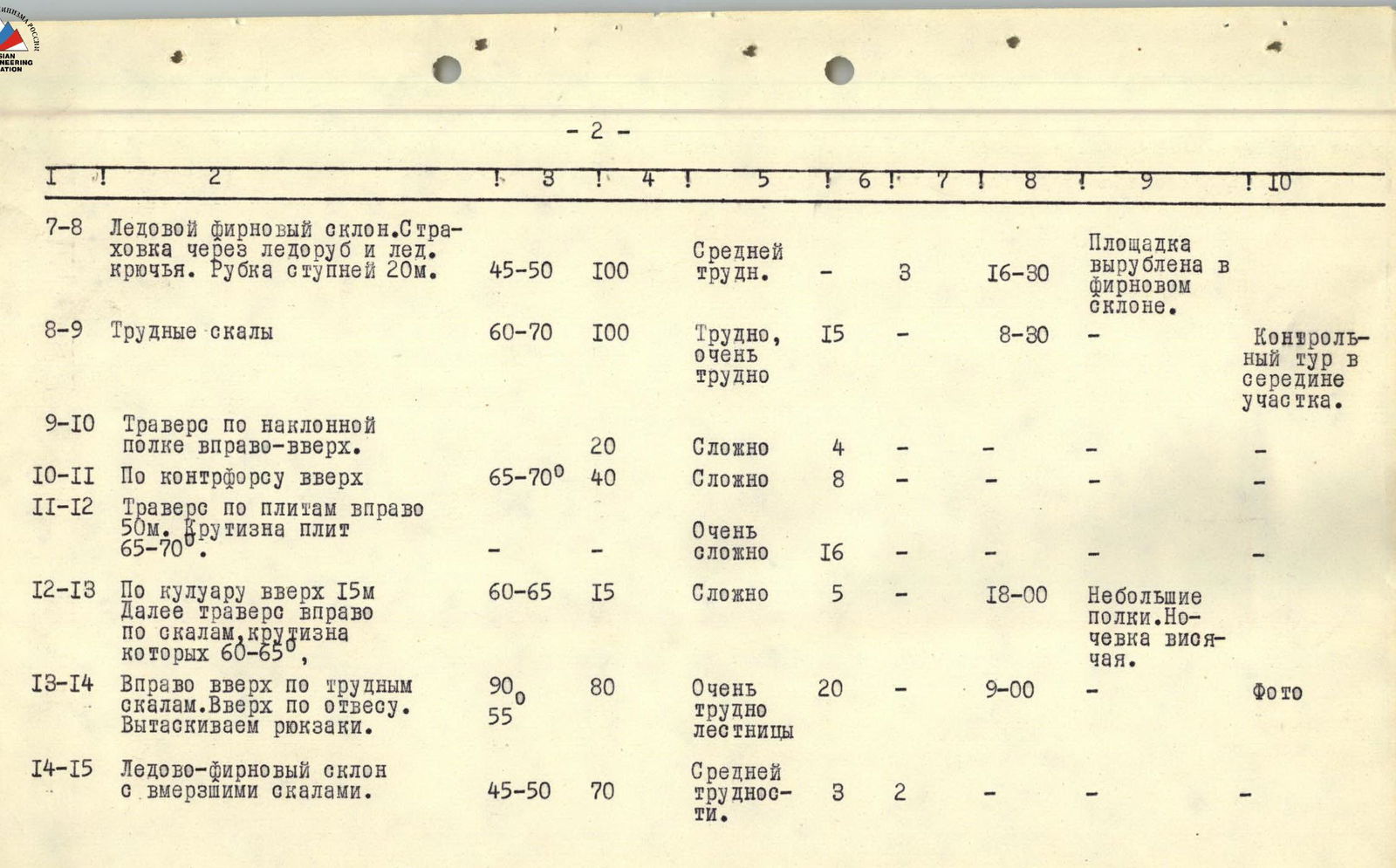
| Section | Brief characteristic of the section, belay method | Steepness | Height gain | Difficulty | Pitons (rock) | Pitons (ice) | Time (start / end of work) | Overnight conditions | Note |
|---|---|---|---|---|---|---|---|---|---|
| R5–R6 | Gentle rocky ridge with snow drifts. Belaying through pitons and outcrops. | 20°–30° | 15 m | Medium labor intensity | 3 | — | 8:30 | — | — |
| R6–R7 | Steep ice-firn slope with rocky outcrops. At the end, an ice wall. | 55°–70° | 60 m | Very complex | 8 | 2 | — | — | (photo) |
| R7–R8 | Ice-firn slope. Belaying through an ice axe and ice pitons. Step-cutting 20 m. | 45°–50° | 100 m | Medium difficulty | — | 3 | 16:30 | Platform cut in the firn slope. | — |
| R8–R9 | Difficult rocks | 60°–70° | 100 m | Difficult, very difficult | 15 | — | 8:30 | Control cairn in the middle of the section. | — |
| R9–R10 | Traverse along an inclined ledge to the right and up. | — | 20 m | Complex | 4 | — | — | — | — |
| R10–R11 | Up along the counterfort | 65°–70° | 40 m | Complex | 8 | — | — | — | — |
| R11–R12 | Traverse along slabs to the right 50 m. Steepness of the slabs 65°–70°. | — | — | Very complex | 16 | — | — | — | — |
| R12–R13 | Up the couloir 15 m. Then traverse to the right along rocks with a steepness of 60°–65°. | 60°–65° | 15 m | Complex | 5 | — | 18:00 | Small ledges. Overnight stop is hanging. | — |
| R13–R14 | To the right and up along difficult rocks. Up a sheer face. Pulling up backpacks. | 90°–55° | 80 m | Very difficult, with ladder use | 20 | — | 9:00 | — | (photo) |
| R14–R15 | Ice-firn slope with embedded rocks. | 45°–50° | 70 m | Medium difficulty. | 3 | 2 | — | — | — |

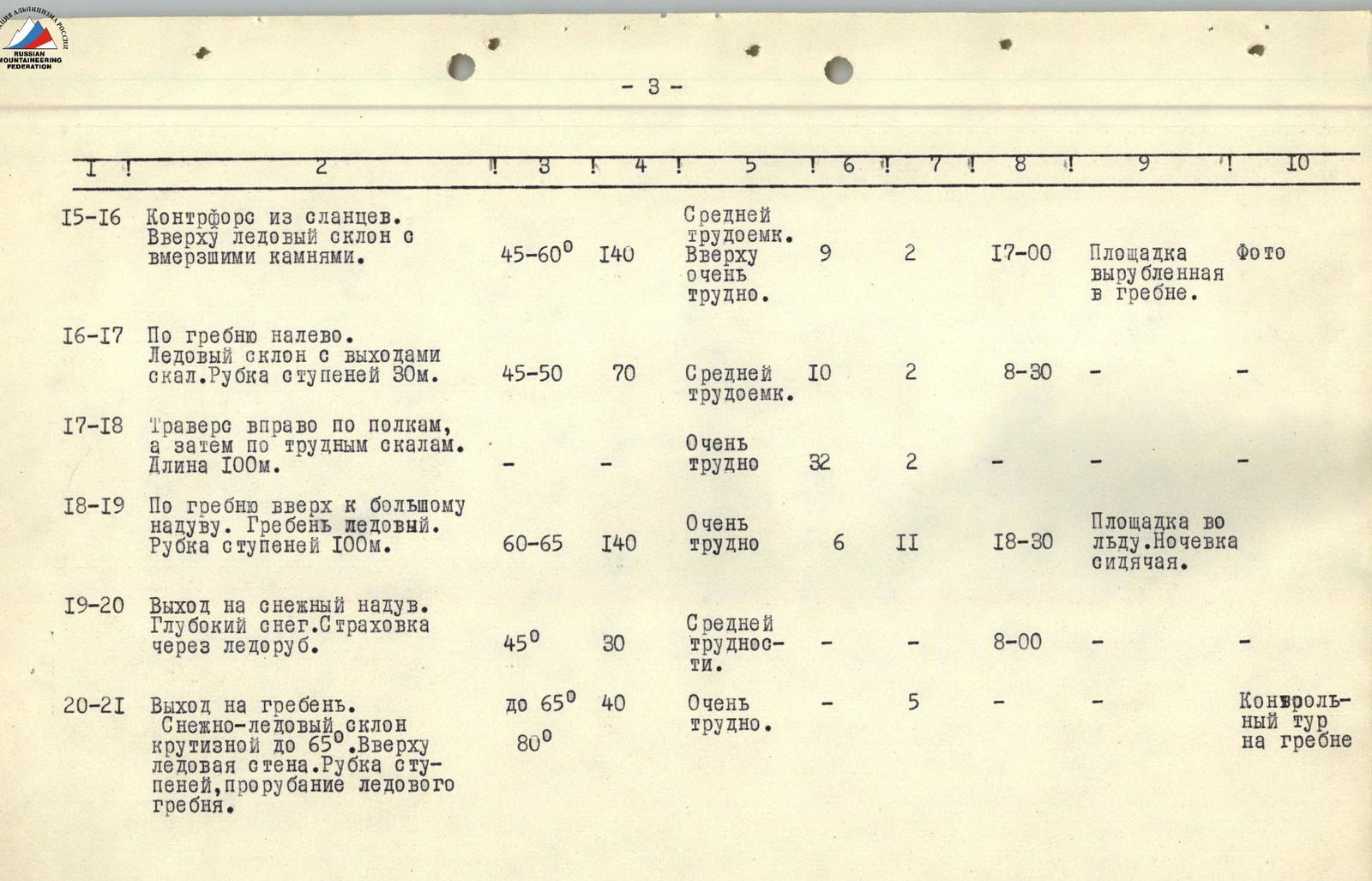
| Section | Brief characteristic of the section, belay method | Steepness | Height gain | Difficulty | Pitons (rock) | Pitons (ice) | Time (start / end of work) | Overnight conditions | Note |
|---|---|---|---|---|---|---|---|---|---|
| R15–R16 | Counterfort made of schist. At the top, an ice slope with embedded stones. | 45°–60° | 140 m | Medium labor intensity. Very difficult at the top. | 9 | 2 | 17:00 | Platform cut in the ridge. | (photo) |
| R16–R17 | Along the ridge to the left. Ice slope with rock outcrops. Step-cutting 30 m. | 45°–50° | 70 m | Medium labor intensity. | 10 | 2 | 8:30 | — | — |
| R17–R18 | Traverse to the right along ledges, and then along difficult rocks. Length 100 m. | — | — | Very difficult | 32 | 2 | — | — | — |
| R18–R19 | Up the ridge to a large snow drift. Icy ridge. Step-cutting 100 m. | 60°–65° | 140 m | Very difficult | 6 | 11 | 18:30 | Platform in the ice. Overnight stop is sitting. | — |
| R19–R20 | Reaching a snow drift. Deep snow. Belaying through an ice axe. | 45° | 30 m | Medium difficulty. | — | — | 8:00 | — | — |
| R20–R21 | Reaching the ridge. Snow-ice slope with steepness up to 65°. At the top, an ice wall. Step-cutting, clearing the icy ridge. | up to 65°, 80° | 40 m | Very difficult. | — | 5 | — | Control cairn on the ridge | — |
| R21–R22 | Ridge with cornices to the right. Belaying through an ice axe. | — | 70 m | — | — | — | 14:00 | — | — |
| Total | 1370 m | 141 | 29 | 48 h 30 min |