Ascent Passport
- Ascent category: technical
- Ascent area: Central Pamir, Akademiya Nauk Range.
- Ascent via the western ridge of Peak 5320 m.
- Ascent characteristics:
- elevation gain – 2000 m
- average steepness – 50°
- length of complex section – 500 m
- Pitons used:
- rock – 18 pcs.
- ice – 10 pcs.
- bolted –
- Time to summit – 25 h.
- Number of bivouacs: two
- first in a tent on a rocky ridge.
- second in a snow-ice depression in a tent.
- Team from "Vysotnik" sports camp, Novosibirsk
- Leader – Nikolai D. Kopytin, 1st sports category
- Participant – Vladimir M. Avdoshin, 1st sports category
- Participant – Yuri N. Korenkov, Candidate Master of Sports
- Participant – Oleg V. Endelin, 1st sports category
 www.alp-federation.ru↗
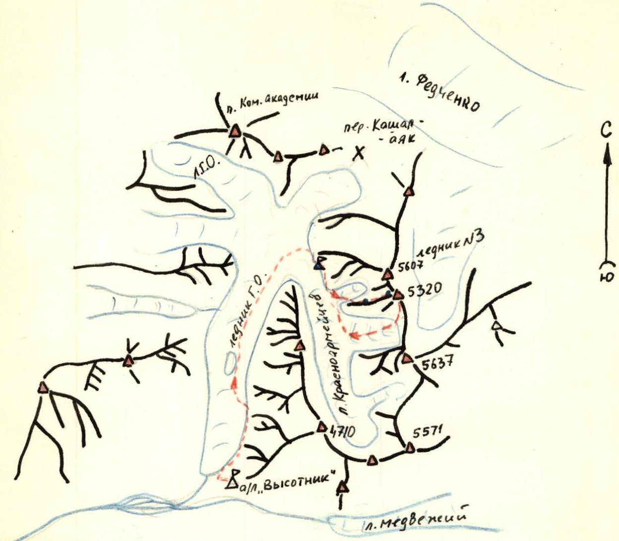
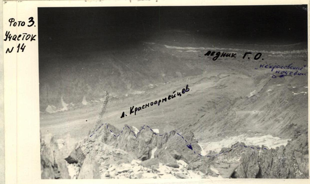
Area map of the ascent. Legend:
- б – initial bivouac;
- --- – overnight stays on the route;
- — Group's route;
- — summit;
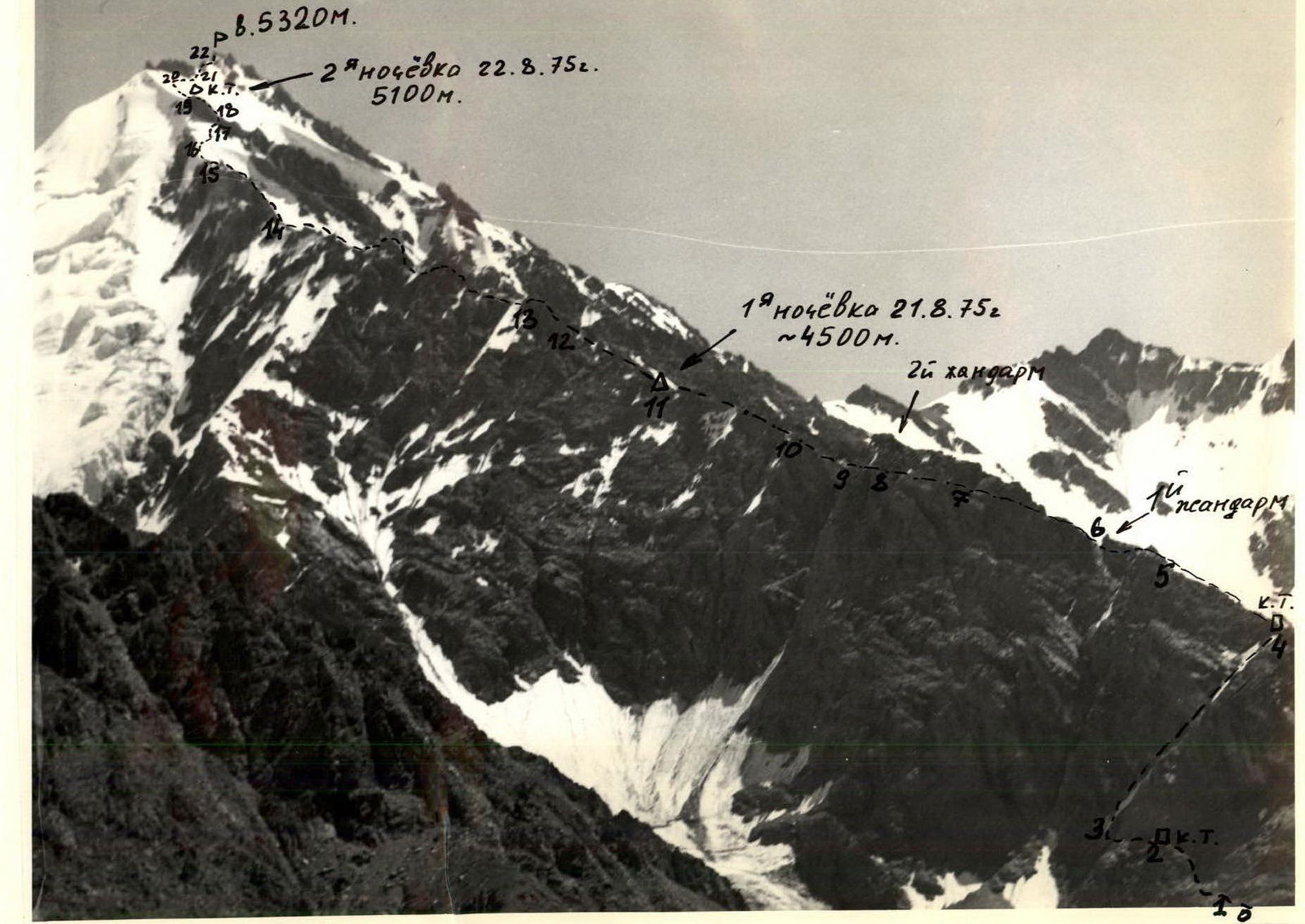
Peak 5320 m is located in the Central Pamir in the Akademiya Nauk Range, on the ridge separating the Lednik Krasnoarmeytsev and Lednik #3, which flows into Lake Fedchenko (see map). The approach from the "Vysotnik" sports camp base in the upper reaches of the Vanch valley via the Lednik Geograficheskogo Obshchestva (GO) to the overnight stays at the confluence of the GO and Krasnoarmeytsev glaciers takes 5–6 h ("Nekrasovskie" overnight stays). From the overnight stays, moving along the right (orographic) grassy moraines of the Krasnoarmeytsev glacier, crossing two streams flowing from the glaciers on the western slopes of Peaks 5604 m and 5320 m, to the start of the route takes 2 h.
Day 1. August 21, 1975
Ascent to the ridge
Along a grassy slope with a slope angle of up to 40° along the 2nd stream in the direction of a characteristic triangular gendarme on the ridge to the rocks.
Rocks of medium difficulty to the left and upwards 40 m, exit to a wide ledge. Traverse left to a rocky couloir, ascent through it to the left 40 m to a characteristic outcrop. Here is the 1st control point.
A platform, possible overnight stay (3 h from "Nekrasovskie" overnight stays).
Further:
- Traverse left along the ledge 80 m to a couloir leading to the right onto the ridge.
- In the upper part of the couloir – ice, 80 m, steepness 55°–70°.
- Ascent via slabs in the right part of the couloir.
- Piton protection!
Upon exiting onto the ridge – 2nd control point. Total length of the couloir – 200 m. 3 h from the "outcrop".
Movement along the ridge
Initially, a very broken wide ridge. Movement along it – 1 h.
Bypassing a not very pronounced 1st gendarme:
- via ledges on the left.
Then movement:
- to the right along the ridge – about 1 h.
Protection methods:
- simultaneous;
- alternate via outcrops.
The second gendarme is bypassed to the right via a traverse. 60 m of complex climbing (photo #1).
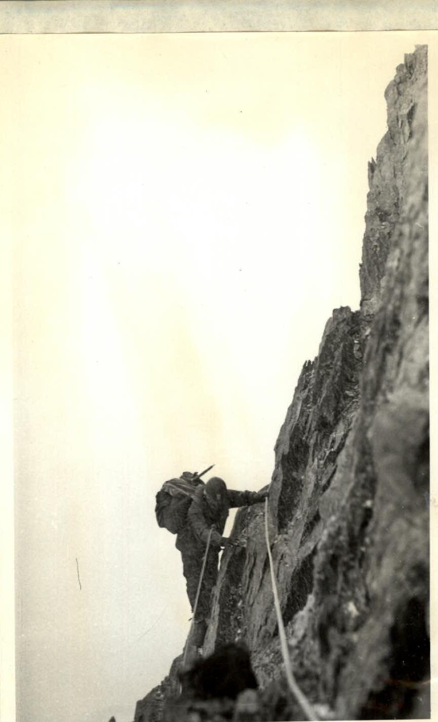
Section 8. Traverse of the 2nd gendarme. 4 pitons used. 60 m.
Piton protection. Descent via climbing 40 m on rocks of medium difficulty to the base of a narrow rocky couloir, which turns into a chimney in its upper part (photo #2).
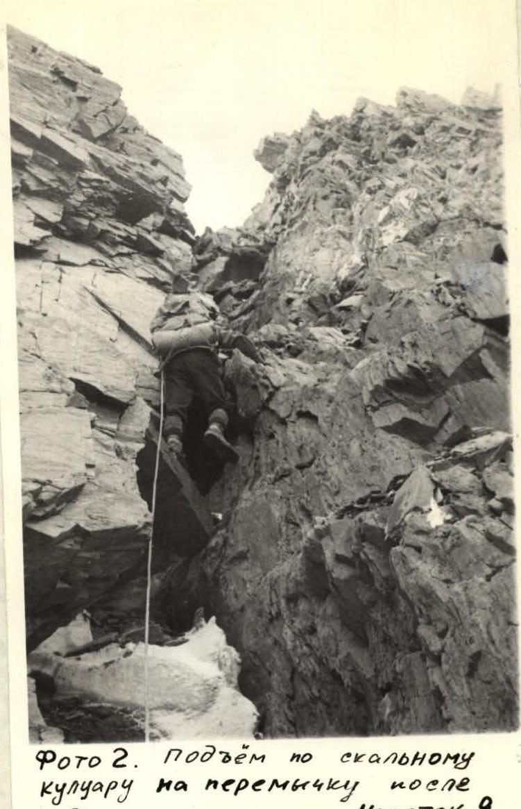
The length of the couloir is 50 m. The chimney leads to a narrow saddle after the 2nd gendarme.
From the saddle, a 20 m rocky wall. Broken rocks!!! Further, the broken ridge is traversed with alternate protection.
1 h of movement along the ridge – a platform for an overnight stay.
10–12 h from "Nekrasovskie" overnight stays.
Day 2. August 22, 1975
From the overnight stays:
- upwards
- to the right, bypassing a not very pronounced gendarme
Movement for about 1 h. Exit to the ridge before a wide couloir separating the main ridge from the southwestern one.
Exit to the base of a yellow gendarme, which is climbed directly. 15 m of complex climbing with piton protection. Then movement along a sharp ridge, overcoming several gendarmes (photo #3).
3 h of movement – approach to an icy ridge. 60 m to a rocky outcrop. Ice steepness – up to 70°. From the rocky outcrop – 2 ropes on an icy slope with a steepness of 50° – towards a rocky gendarme. Ice sections are overcome in crampons with protection via ice and rock (on the rocky outcrop) pitons. The gendarme is overcome to the right via an inner corner with flowstone, 30 m – complex climbing with piton protection. Then 1.5 ropes on broken rocks – to the top of the gendarme. Overnight stay in a snow-ice depression. 10 h from the overnight stays on the ridge.
Day 3. August 23, 1975
From the overnight stays – 5 ropes on an icy slope with three rocky outcrops. Slope steepness 50°–60°. Climbed in crampons with ice pitons. From the last rocky outcrop, a traverse to the right bypasses several gendarmes on broken rocks towards a pre-summit gendarme, which is climbed directly via rocks of medium difficulty.
The summit is a 10 m rocky tower, which is climbed with piton protection (complex climbing) (photo #4).

5 h from the last overnight stays.
Descent from the summit
Along a wide broken southern ridge, transitioning into a steep snow-ice descent to a saddle. From the saddle, along a wide snow-ice couloir and then along a gentle glacier to the Krasnoarmeytsev glacier. Descent from the summit to "Nekrasovskie" overnight stays takes 7–8 h.
Conclusion
The ascent via the western ridge of Peak 5320 m, leading directly to the summit, represents a logical route not lower than category 4B.
Recommendations
- For a team of four, the necessary equipment is:
- Main rope – 2×40 m
- Rock pitons – 10 pcs.
- Ice pitons – 7 pcs.
- Crampons – 4 pairs
- Hammers – 2 pcs.
- Tent, stove
- Food supply – 3 days.
- Initial bivouac – "Nekrasovskie" overnight stays on the moraine at the confluence of the Geograficheskogo Obshchestva and Krasnoarmeytsev glaciers.
- Ice sections in the upper part of the route should be climbed early in the morning.
- Number of participants – 4 people.
- Possible bivouac locations – on the ridge after the 2nd gendarme, on the ridge before the icy section, on the top of the gendarme after the 1st icy section, on the summit.
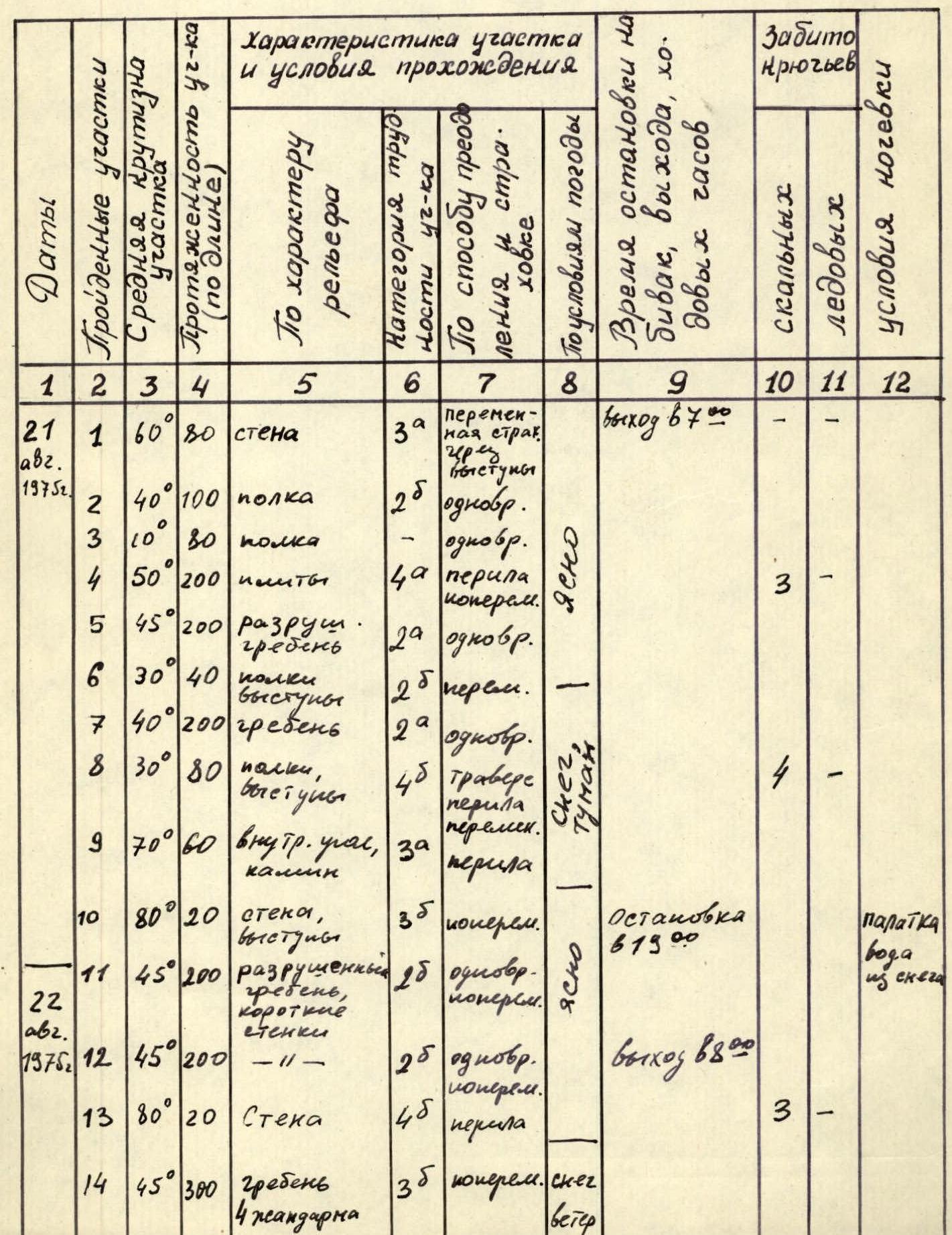
Table of main characteristics of the ascent route
Ascent to Peak 5320 m via the western ridge
| 1 | 2 | 3 | 4 | 5 | 6 | 7 | 8 | 9 | 10 | 11 | 12 |
|---|---|---|---|---|---|---|---|---|---|---|---|
| Dates | |||||||||||
| Aug 21, 1975 | 1 | 60° | 80 | wall | 3 | alternate protection via outcrops | Departure at 7:00 | ||||
| 2 | 40° | 100 | ledge | 2 | simultaneous | ||||||
| 3 | 10° | 30 | ledge | 2 | simultaneous | ||||||
| 4 | 50° | 200 | slabs | 4 | rope, alternate | clear | – | 3 | |||
| 5 | 45° | 200 | broken ridge | 2 | simultaneous | ||||||
| 6 | 30° | 40 | ledges, outcrops | 2 | alternate | ||||||
| 7 | 40° | 200 | ridge | 2 | simultaneous | ||||||
| 8 | 30° | 80 | ledges, outcrops | 4 | traverse, alternate, rope | – | 4 | ||||
| 9 | 70° | 60 | inner corner, chimney | 3 | rope | fog | 2 | – | |||
| 10 | 80° | 20 | wall, outcrops | 3 | alternate | clear | Stop at 19:00 | ||||
| Aug 22, 1975 | 11 | 45° | 200 | broken short walls | 2 | simultaneous, alternate | – | 3 | tent, water from snow | ||
| 12 | 45° | 200 | - // - | 2 | simultaneous, alternate | Departure at 8:00 | |||||
| 13 | 80° | 20 | wall | 4 | rope | 3 | |||||
| 14 | 45° | 300 | ridge, 4 gendarmes | 3 | alternate | snow, wind | |||||
| 15 | 60° | 150 | broken ridge | 2 | alternate | snow, simultaneous wind | |||||
| 16 | 60° | 60 | ice | 4 | crampons, clear, rope | 2 | 4 | ||||
| 17 | 45° | 70 | ice | 3 | -//- | 1 | 3 | ||||
| 18 | 70° | 30 | inner corner, flowstone | 4 | rope | 2 | – | ||||
| 19 | 50° | 60 | broken rocks | 2 | alternate | Stop at 19:10 | |||||
| Aug 23, 1975 | 20 | 50° | 200 | ice, rocky outcrops | 4 | crampons, clear, rope | departure at 6:30 | – | 3 | tent, wind, frost, water from snow. | |
| 21 | 40° | 100 | ice, rocky walls | 3 | alternate | -//- | |||||
| 22 | 60° | 40 | rocky walls | 5 | rope, clear, alternate | reached the summit at 13:00 | 3 | – |
Team Captain
Kopytin


