Ascent Passport
- Ascent class — high-altitude
- Ascent area — Pamir, Academy of Sciences Range (4.1)
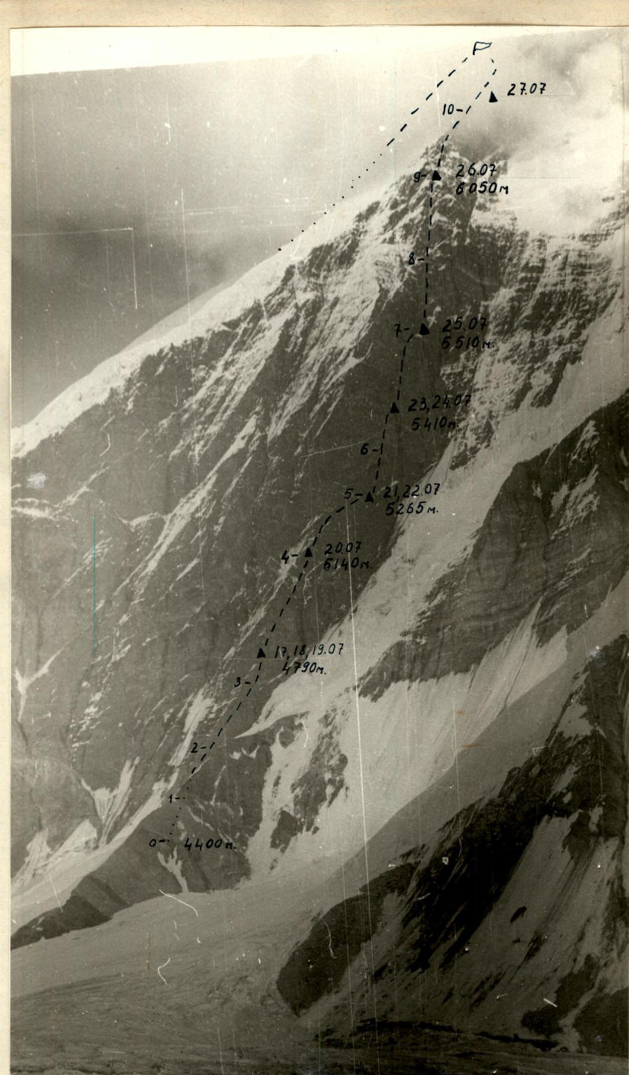
- Peak, its height, and ascent route — Peak K. Zetkin, 6680 m, West face.
- Difficulty category — 6B
- Route characteristics: height difference — 2280 m, average steepness — 73°, length of complex sections — 834 m.
- Pitons hammered for insurance: rock — 249, ice — 12.
- Number of travel hours — 77.
- Number of nights — 13.
- Surname, name, patronymic of the leader and participants: Dyachenko Nikolai Nikolaevich — MS USSR, Pugachev Alexander Lvovich — CMS, Koraunin Yuri Konstantinovich — CMS, Ovchinnikov Alexey Nikolaevich — CMS.
- Team coach — N.N. Dyachenko.
- Exit to the route — July 17, return to base camp — July 30.
Route Description
07/17. We set out on the route at 5:00. The path goes along a snow-firn slope. We crossed the bergschrund along a fresh avalanche debris. The slope steepness increases, turning into a rock wall. The rock is grey shale, heavily destroyed, but the overall steepness is close to 65°. Movement is carried out by independent rope teams. At 10:00, the weather sharply deteriorated — wet snow, fog. At 12:00, we stopped hoping to wait out the bad weather. However, the snowfall did not stop, we cleared a site, the place is inconvenient — a semi-reclining overnight stay.
07/18. The weather is not improving, 20 m slightly to the right we found a more convenient place for a tent. Overnight stay is comfortable — a wide site (the construction of which took 2–2.5 hours) is protected from above by a 40-meter wall.
07/19. It snowed at night, fog in the morning. From 9:00 to 11:00, we hung two ropes. The entire route is clogged with snow. From 11:00, avalanches and stones went down, movement is very dangerous.
07/20. We left at 8:00. The rocks are covered with snow. The most difficult section is when approaching the main wall, to the second overnight stay of the army climbers. An inner corner turning into a chimney, the overall steepness of this section is close to 90°, the rocks are covered with a thin layer of ice. We stopped for the night at 14:00. Further movement or processing is impossible due to the melting of freshly fallen snow.
07/21. We left at 9:00. Ascent under the rock ledge along the wall with a vertical slit. Then transition to a shelf (1–1.5 ropes). The movement is not technically difficult, but the rocks are heavily destroyed, there are many loose stones.
- 40 m from the beginning of the shelf, a transition (step 5 m).
- Further up and to the right.
We stopped for the night at 17:00, the site is convenient (we descended a bit lower onto a shelf with snow).
07/22. We left at 8:00, but the rocks are covered with rime, galoshes do not hold, so we postponed the exit until 10:00. Exit through a chimney under an overhanging wall. Technically difficult exit through a chimney, and then along an inclined slab, from above an overhanging cornice facilitates movement, as you can hammer pitons into it. Further movement along the wall to the right and upwards "around the corner". This is perhaps the most psychologically unpleasant section of the entire route, as the wall is very steep (80°), and the rock is heavily destroyed, making both passage and organization of reliable insurance difficult. At 16:00, we finished processing as stones and huge icicles began to fall from above. Overnight stay at the old place.
07/23. We passed the processed route, hung two more ropes. The route is technically difficult, but unlike the previous section — the rocks are strong with many cracks and ledges. We stopped for the night early (at 14:00), as in one of the sections water cascades down from above (the first ascenders suffered in these areas due to lack of water).
07/24. Continued processing the rock ledge. The average steepness is close to vertical. This is technically the most difficult section of the entire route, especially the exit along a smooth wall with some negative slope (90–95°, 20–25 m). Many pitons of previous climbers (8 rock, 1 — bolt).
07/25. We left at 9:00. Passing the processed route, even on a fixed rope, is very laborious — constantly being "thrown back". In six travel hours, we reached the area of the "white patch", considering that the previous two overnight stays were very uncomfortable (each person was separate), we decided to stop for the night. Convenient and safe wide shelf.
07/26. Exit at 9:00. From the "white patch" exit upwards along a heavily destroyed, not clearly defined ridge, then along slabs with an exit to a shale wall. Further path upwards and to the left under pronounced "yellow" blocks. The rocks are warm with many ledges. Before exiting to the ridge, a short "yellow-grey" wall, at the top — a piton of army climbers. We stopped for the night at 17:00. Overnight stay is comfortable.
07/27. Exit at 9:00. According to the plan, we were supposed to reach the summit and descend to the saddle on this day. However, progress was complicated by the fact that the ridge is mostly composed of shale rocks. A layer of fresh snow lies very unsteadily on the slabs, and the tile-like structure of the slabs ("fish scales") made it impossible to climb in crampons (which we had hoped for). The Vibram sole is frozen — another surprise. Therefore, the first person climbs in galoshes with careful piton insurance. In the second half of the day, the weather deteriorated. By 18:00, the first rope team reached the summit, the second — stopped, not reaching one rope length to the summit, in a convenient snow mulde, which is overlapped from the north by a sheer rock.
07/28. Exit at 10:00. Descent to the saddle along a snowy ridge. Wind, snow in the morning. Two hours after the exit, thick snow started falling, visibility is zero. To the right along the path — huge cornices, to the left — a steep snow-firn slope turning into drops. Often had to stop and wait for the next clearing. Around 15:00, we descended to the saddle.
07/29. It snowed all night. We began the descent from the saddle at 11:00 along the rocks. The rocks are covered with ice, many pitons of previous climbers. After four hours, we were forced to stop under the protection of a rock wall. Visibility is zero, further descent is very dangerous, as snow is constantly falling from above in the form of small avalanches.
07/30. Early in the morning, we saw that 70–80 m separated us from the glacier. Having hung two rappels, by 7:00 we descended to the glacier. 40 minutes later, approaching the overnight stays under Peak "Chetyrekh", we met our observers.
Table of main characteristics of the ascent route.
| № | Passed sections | Average steepness of section in degrees | Length of section in m | Characteristics of section and passage conditions | Difficulty category | By method of overcoming and insurance | By weather conditions | Time of stop for bivouac, exit, travel hours | Hammered rock pitons | Hammered ice pitons | Hammered bolt pitons | By bivouac conditions |
|---|---|---|---|---|---|---|---|---|---|---|---|---|
| 1 | 2 | 3 | 4 | 5 | 6 | 7 | 8 | 9 | 10 | 11 | 12 | 13 |
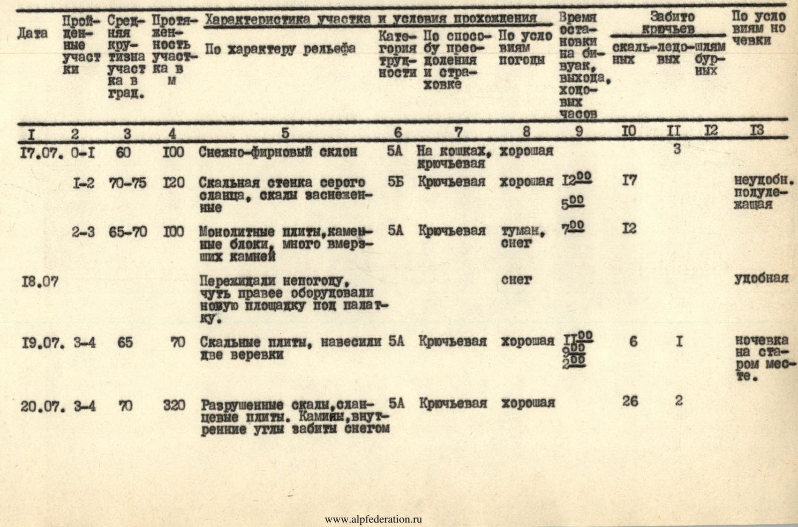
| 17.07 | 0–1 | 60 | 100 | Snow-firn slope | 5А | On crampons, good piton insurance | 3 | |||||
| 1–2 | 70–75 | 120 | Rock wall of grey shale, rocks snow-covered | 5Б | Piton insurance | good | 12:00, 5:00 | 17 | uncomfortable, semi-reclined | |||
| 2–3 | 65–70 | 100 | Monolithic slabs, stone blocks, many embedded stones | 5А | Piton insurance | fog, snow | 7:00 | 12 | ||||
| 18.07 | Waited out bad weather, slightly to the right equipped a new site for the tent. | snow | comfortable | |||||||||
| 19.07 | 3–4 | 65 | 70 | Rock slabs, hung two ropes | 5А | Piton insurance | good | 11:00, 2:00 | 6 | 1 | overnight stay at old place | |
| 20.07 | 3–4 | 70 | 320 | Destroyed rocks, shale slabs. Chimney, inner corners clogged with snow | 5А | Piton insurance | good | 26 | 2 | |||
| 75–85 | 30 | Inner corner turns into a sheer chimney | 5Б | In galoshes, piton insurance | 14:00, 6:00, 8:00, 6:00 | 7 | comfortable | |||||
| 21.07 | 4–5 | 80 | 40 | Rock wall turning into stepped blocks — exit under ledge | 5Б | In galoshes, piton insurance | 9 | |||||
| 20 | 40 | Rock shelf, traverse to the right | 4А | 2 | ||||||||
| 90 | 5 | "Step" — slab with few ledges | 6 | " | 17:00, 9:00, 2:00 | 3 | comfortable | |||||
| 85 | 40 | Wall of tile-like structure | 6 | 12 | ||||||||
| 22.07 | 5–6 | 85 | 50 | Inner corner, chimney, exit under overhang (1.5–2 m). Along a narrow shelf up and to the right (crawling under overhang) | 6 | " | good | 14 | ||||
| 80–90 | 40 | Wall of fragile, heavily destroyed rocks, ledges and cracks very unreliable | 6 | " | 16:00, 10:00, 6:00 | 13 | overnight stay at old place | |||||
| 23.07 | 6–7 | 80 | 55 | Passed processed section. Wall of block structure, many ledges. Sloping shelf under overhanging wall with large ledge (army climbers' bolt) | 5Б | In galoshes, good piton insurance | 14:00, 8:00, 6:00 | 7 | hanging, uncomfortable | |||
| 24.07 | 6–7 | 90–95 | 25 | Overhanging wall | 6 | " | good | 17:00, 6:00 | 17 | hanging, uncomfortable | ||
| 60 | 20 | To the right and upwards rocks of block structure | 5А | 8:00 | 2 | |||||||
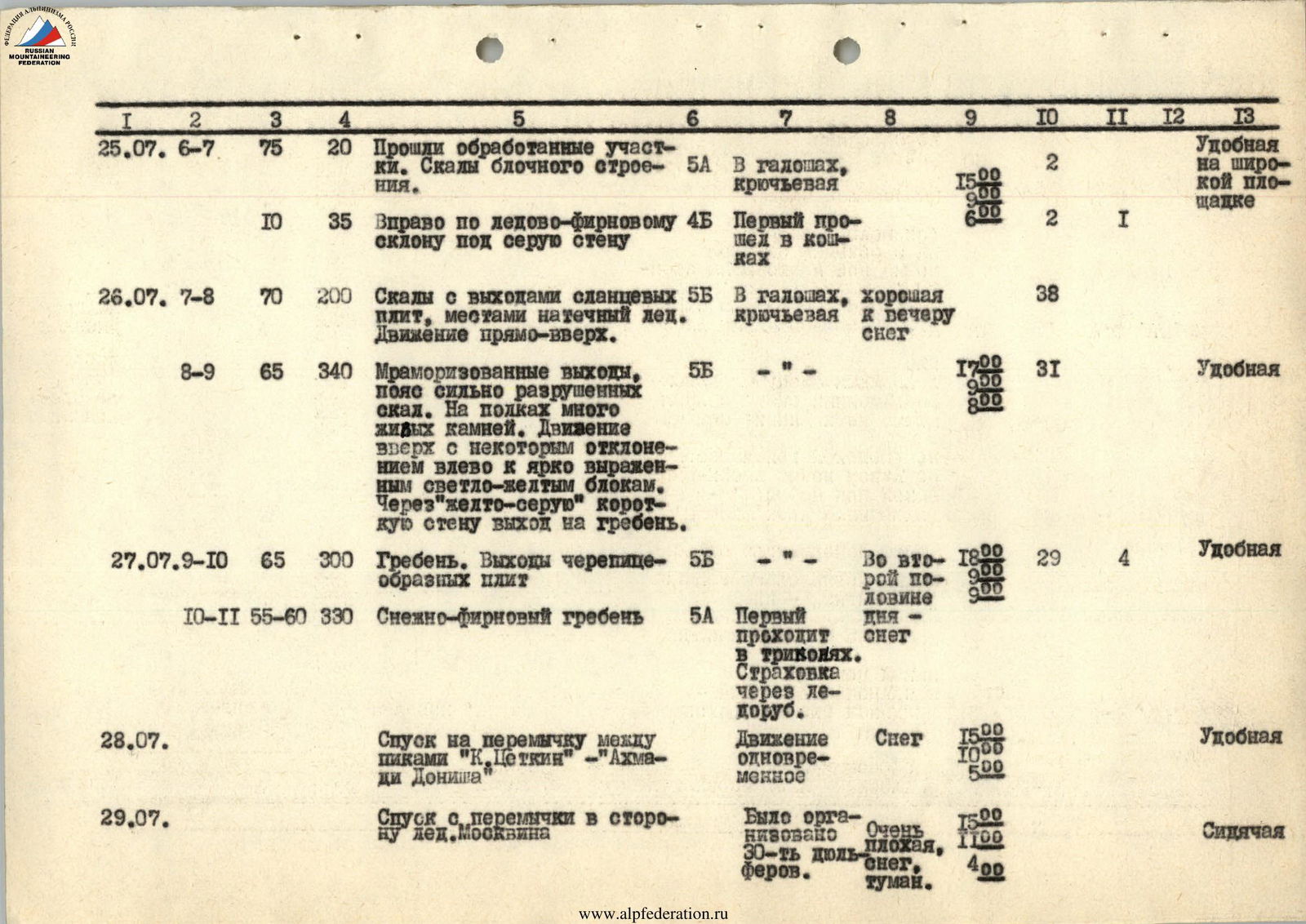
| 25.07 | 6–7 | 75 | 20 | Passed processed sections. Rocks of block structure. | 5А | In galoshes, piton insurance | 15:00, 9:00 | 2 | comfortable on a wide site | |||
| 10 | 35 | To the right along ice-firn slope under grey wall | 4Б | First passed in crampons | 6:00 | 2 | 1 | |||||
| 26.07 | 7–8 | 70 | 200 | Rocks with outcrops of shale slabs, местами натёчный лёд. Movement straight up. | 5Б | In galoshes, piton insurance | towards evening snow | 38 | ||||
| 8–9 | 65 | 340 | Marmorized outcrops, zone of heavily destroyed rocks. On shelves many loose stones. Movement upwards with some deviation to the left towards pronounced light-yellow blocks. Through "yellow-grey" short wall exit to the ridge. | 5Б | " | 17:00, 0:00, 8:00 | 31 | comfortable | ||||
| 27.07 | 9–10 | 65 | 300 | Ridge. Outcrops of tile-like slabs | 5Б | " | In the second half of the day | 18:00, 9:00 | 29 | 4 | comfortable | |
| 10–11 | 55–60 | 330 | Snow-firn ridge | 5А | First passes in crampons. Insurance via ice axe. | snow | ||||||
| 28.07 | Descent to the saddle between peaks "K. Zetkin" — "Akhma-di Donish" | Simultaneous movement | Snow | 15:00, 10:00, 5:00 | comfortable | |||||||
| 29.07 | Descent from the saddle towards Moskvin glacier | 30 rappels were organized. | Very bad, snow, fog. | 15:00, 11:00, 4:00 | sitting |