Climbing Passport
- Climbing category — high-altitude
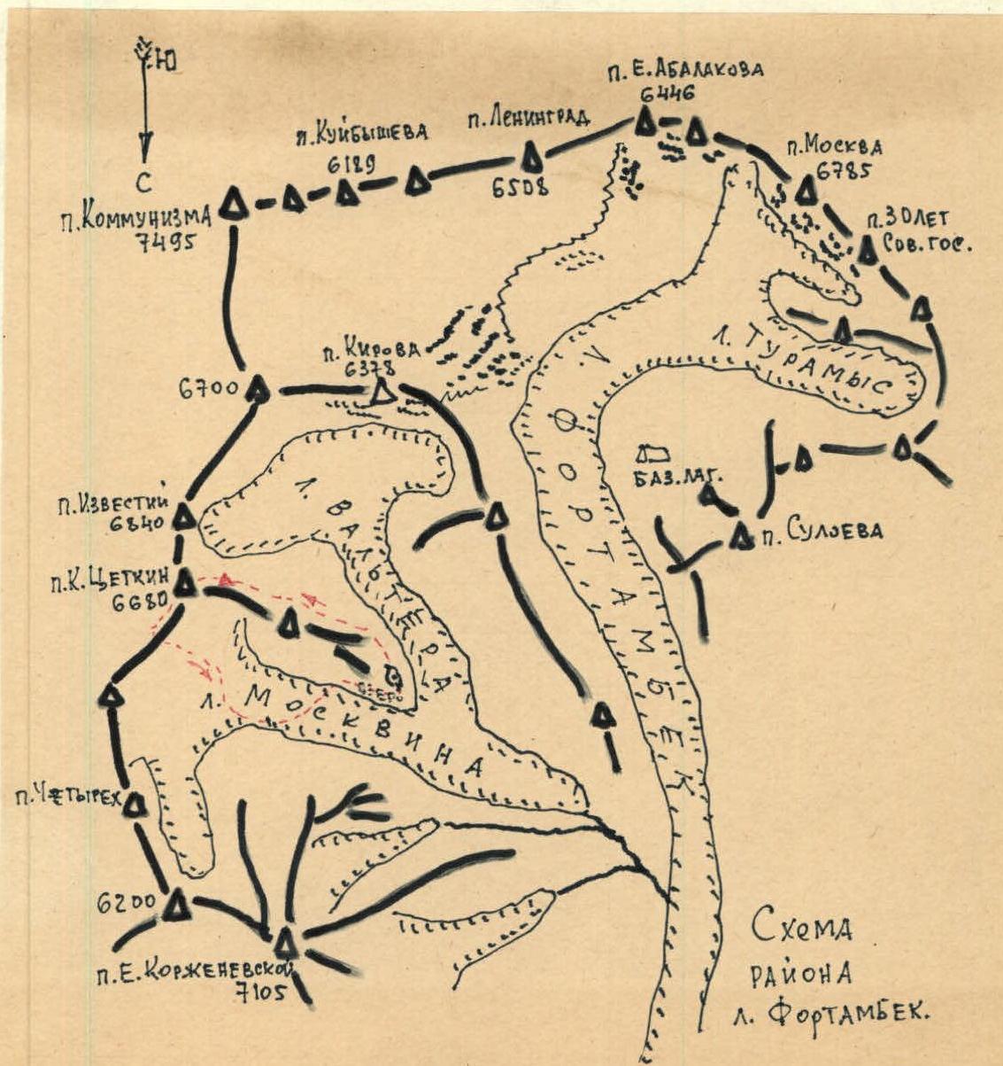
- Climbing area, ridge — Pamir, l. Walter, Academy of Sciences ridge
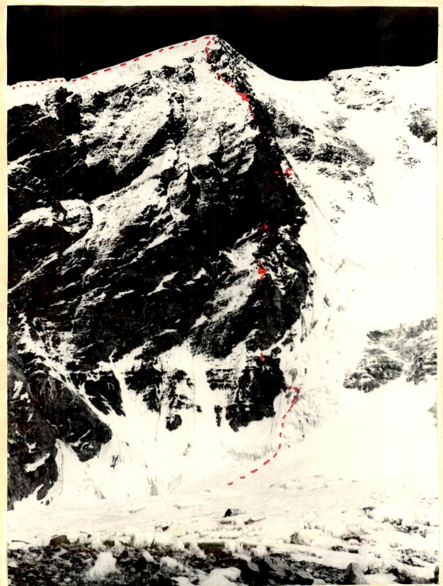
- Peak, its height, route — p. K. Zetkin, 6680 m, via the W wall
- Proposed difficulty category — 6 (second ascent)
- Route characteristics:
height difference — 2150 m. length of sections with 5–6 diff. — 1200 m. average steepness — 70° (the wall itself is 75°)
- Pitons hammered: for belaying — 202 (36 on descent and 20 for bivouac) for creating ITO — 6 rock — 202 ice — 6 bolt — 0 (1 used by first ascenders for ITO)
- Number of climbing hours: 62.5, including 12 on descent.
- Number of bivouacs and their characteristics: 5 on ascent, including 3 sitting, 2 on descent
- Surname, name, patronymic of the leader, participants, and their qualification
Bobrov Vladimir Ivanovich — Candidate Master of Sports, leader
Kurochkin Gennady Alexandrovich — Candidate Master of Sports, participant
Khomutov Valery Vasilyevich — Candidate Master of Sports, participant
Chernoy Nikolai Dmitrievich — Candidate Master of Sports, participant
Team of MGS SDDO "Burvestnik"
10. Team coach: Honored Master of Sports of the USSR, Honored Coach of the RSFSR A. G. Ovchinnikov.
11. August 3 – August 10, 1978
Brief Geographical Overview of the Climbing Area
Peak K. Zetkin is located in the Pamir Mountains in the Academy of Sciences ridge in the upper reaches of the Walter Glacier, which is a tributary of the Moskvina Glacier. The western wall of the peak drops over 2 km vertically onto the Raltsera Glacier. Previously, peak K. Zetkin was ascended only during traverses (Bozhukov's group in 1968). In 1976, the western wall was climbed by a group from SAVO led by Yu. Popenko, for which the team was awarded the Golden Medals of the USSR Climbing Championship 1976.
Approach to the wall:
- From the camp by the lake at the fork of the Walter – Moskvina glaciers, the approach is relatively straightforward.
- Recently, alpinists have been helicoptered to the camp.
Route Description
August 2, 1978. At 11:30, the group was helicoptered to l. Walter by the lake. They departed from the lake at 13:30 and approached the route in the upper reaches of l. Walter. To the right, orographically, on scree near rust-colored rocks, they stopped for the night at 17:00. Radio contact was established with the camp on Fortambek. The connection remained reliable throughout the ascent. August 3, 1978. They departed at 6:30 and around 8:00, after crossing an ice-firn slope, reached the rocks. The group had a very accurate and detailed description of the route, compiled by the first ascenders, Popenko's group. It should be noted that this year there was very little snow, and as a result, the risk of rockfall increased. They covered about 600 m that day, with the last 160 m being very challenging (see table). They stopped at 18:30 on a scree ridge, setting up a tent. However, rockfalls from the left and right of the ridge forced them to descend 40 m along the ridge and re-pitch the tent in a safer, albeit less convenient, location. August 4, 1978. They departed at 10:00. Initially, they moved simultaneously, then alternately across the destroyed rocks of the ridge, which led them to a rocky slope transitioning into a steep rock wall, which then led to an indistinct ridge where they bivouacked, finding a note from the first ascenders. They stopped at 16:00. Movement was alternate. Except for the first person, everyone else climbed using a rope with jumar assistance. The bivouac was sitting in a tent. While setting up the bivouac, the pair Khomutov—Chernoy hung three ropes and returned to the bivouac by 19:00. August 5, 1978. Departure at 10:00. Ahead lay the key section of the route — a sheer rock wall. The main direction was upwards to the right. This was natural since rocks were continuously falling from the left. Initially, they followed the pre-fixed ropes; the first rope went up-left onto a narrow inclined shelf, then right-up another rope, and then through a system of ledges and walls, another rope under a sheer smooth plate (a bolt piton was hammered by the first ascenders). They climbed the fixed ropes using jumars, which took 6 hours. The next rope was very challenging. Backpacks were pulled up 40 m. The first climber went in galoshes. The plate was climbed using a ladder and 1 piton for support. Then another 15 m up through destroyed rocks, and the backpacks were pulled up. It was 19:00, and the location was very uncomfortable, but there was nothing suitable nearby for a bivouac. They had to settle in a sitting position, each person separately, as there was no other option. By 21:00, they finally settled in, fortunately, it was warm. August 6, 1978. They departed late in the morning. The pair Khomutov—Chernoy processed the next rope (described by the first ascenders as very difficult). Indeed, it took 2 hours 30 minutes to process, and then another 2 hours 30 minutes to climb and pull up the backpacks. By 15:00, they reached a simple traverse rope to the right, into the base of a large internal angle. Here, they found a note and a piton from the first ascenders. They constructed a platform and could sit in a tent. While the platform was being built, the Khomutov—Chernoy pair fixed three ropes on the right side of the internal angle. August 7, 1978. Departure at 10:00. In two hours, they climbed 120 m of fixed ropes on a rock wall with fairly solid rocks but had to be cautious of loose stones. Then another 80 m on similar terrain to platforms in the upper part of the internal angle. Then a 40 m traverse to the left under the wall. Further, 20 m up a wall to a system of plates. Under them, 40 m to the left along a scree shelf to a rocky couloir. Then another 40 m of rocks leading to a ridge. Along the rocky ridge, about 160 m, they reached an osypnoy slope with snow by 18:00. They built a platform for a tent and set it up properly. August 8, 1978. Departure at 10:00. Initially, 80 m along a snowy ridge with rock outcrops, then about 180 m along a rock wall, and further approximately 240 m along a rock wall to a firn-ice slope. Along this slope, about 400 m to the summit. Belaying on the slope was with pitons, and then on snow with an ice axe. They reached the summit at 16:00, finding a note from Popenko's group. They began their descent at 16:30 towards the saddle between peak K. Zetkin and Akhmaty Donish. By 18:00, they stopped near a large boulder. The bivouac on snow in a hollow was comfortable. August 9, 1978. Departure at 10:00. By 12:30, they descended to the saddle. Continuing their descent using sports technique on pitons left by the first ascenders (re-hammering and changing slings). By 16:30, having climbed down 10 ropes, they had to take cover under rocks on an indistinct ridge due to the onset of rockfall. They couldn't continue. They bivouacked sitting on a narrow ledge. August 10, 1978. Departure was early at 6:00, while the rocks were quiet. Another 20 sports descents, and they reached l. Moskvina by 12:00 and the lake by 15:00.
TABLE OF MAIN CHARACTERISTICS OF THE ASCENT ROUTE
Ascent route: West wall of peak K. Zetkin-6, second ascent Height difference: 2150 m. Length of complex sections: 1200 m. Average steepness: 70° (average steepness of the wall itself is 75°)
Characteristics of section R2–R3
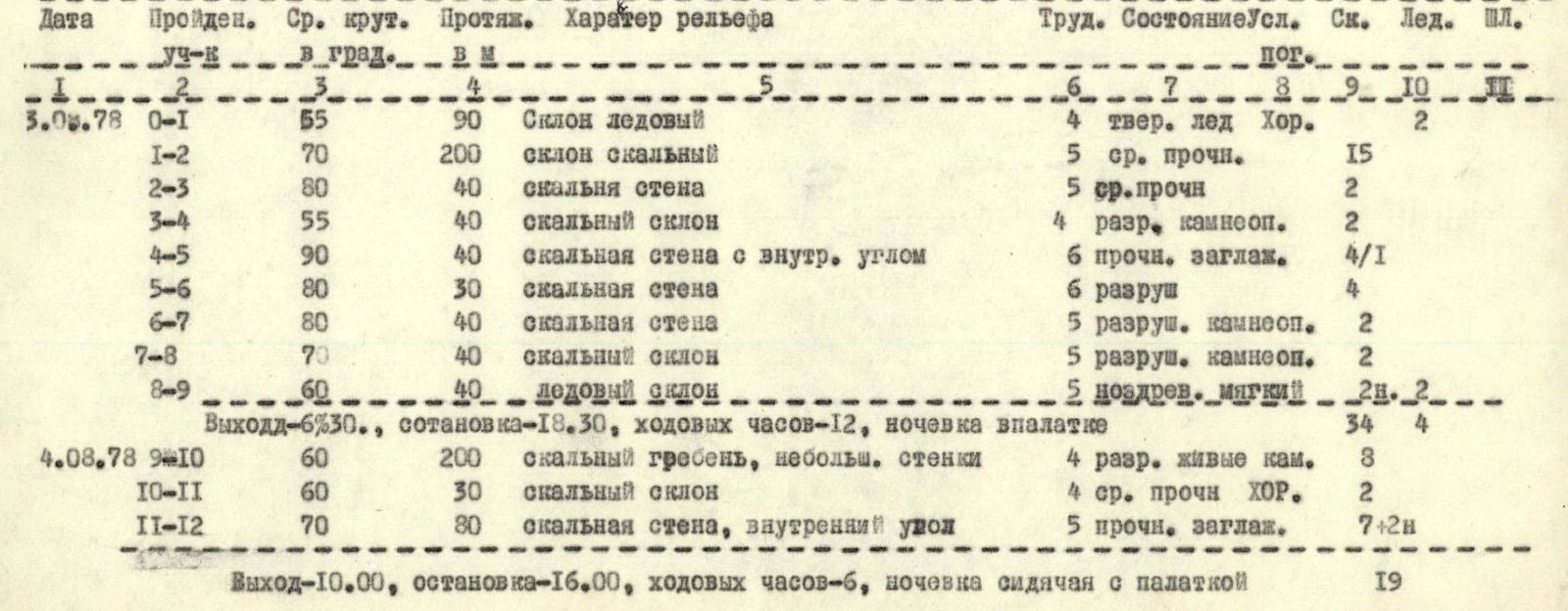
| Date | Section passed | Avg. steepness in degrees | Length in m | Terrain characteristics | Diff. cond. | State of conditions | Rock | Ice | Bolt |
|---|---|---|---|---|---|---|---|---|---|
| 3.08.78 | 0–1 | 55 | 90 | Ice slope | 4 | firm ice Good | 2 | ||
| 3.08.78 | 1–2 | 70 | 200 | Rocky slope | 5 | medium strength | 15 | ||
| 3.08.78 | 2–3 | 80 | 40 | Rock wall | 5 | medium strength | 2 | ||
| 3.08.78 | 3–4 | 55 | 40 | Rocky slope | 4 | destroyed, rockfall | 2 | ||
| 3.08.78 | 4–5 | 90 | 40 | Rock wall with internal angle | 6 | strong, smooth | 4 | 1 | |
| 3.08.78 | 5–6 | 80 | 30 | Rock wall | 6 | destroyed | 4 | ||
| 3.08.78 | 6–7 | 80 | 40 | Rock wall | 5 | destroyed, rockfall | 2 | ||
| 3.08.78 | 7–8 | 70 | 40 | Rocky slope | 5 | destroyed, rockfall | 2 | ||
| 3.08.78 | 8–9 | 60 | 40 | Ice slope | 5 | porous, soft | 2Б | 2 | |
| Departure–6:30, stop–18:30, climbing hours–12, overnight in a tent | 34 | 4 | |||||||
| 4.08.78 | 9–10 | 60 | 200 | Rocky ridge, small walls | 4 | destroyed, loose rocks | 8 | ||
| 4.08.78 | 10–11 | 60 | 30 | Rocky slope | 4 | medium strength Good | 2 | ||
| 4.08.78 | 11–12 | 70 | 80 | Rock wall, internal angle | 5 | strong, smooth | 7 | 2Б | |
| Departure–10:00, stop–16:00, climbing hours–6, sitting bivouac with tent | 19 | ||||||||
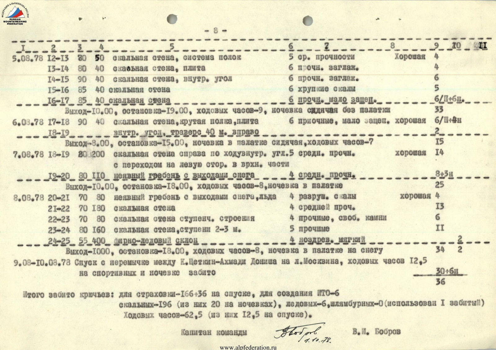
| 5.08.78 | 12–13 | 80 | 50 | Rock wall, system of ledges | 5 | medium strength Good | 4 | ||
| 5.08.78 | 13–14 | 80 | 40 | Rock wall, plate | 6 | strong, smooth | 4 | ||
| 5.08.78 | 14–15 | 90 | 40 | Rock wall, internal angle | 6 | strong, smooth | 6 | ||
| 5 | 15–16 | 85 | 40 | Rock wall | 6 | fragile rocks | 5 | ||
| 5.08.78 | 16–17 | 85 | 40 | Rock wall | 6 | strong, few holds | 6 | П+БН | |
| Departure–10:00, stop–19:00, climbing hours–9, sitting bivouac without tent | 33 | ||||||||
| 6.08.78 | 17–18 | 90 | 40 | Rock wall, steep ledge, plate | 6 | strong, few holds Good | 6 | П+ЗН | |
| 6.08.78 | 18–19 | Internal angle, 40 m traverse to the right | 2 | ||||||
| Departure–8:00, stop–15:00, sitting bivouac with tent, climbing hours–7 | 15 | ||||||||
| 7.08.78 | 18–19 | 80 | 200 | Rock wall on the right side of the internal angle, 5 medium strength | Good | 14 | |||
| 7.08.78 | 19–20 | 80 | 110 | Indistinct ridge with snow outcrops | 4 | medium strength | 8 | ЗН | |
| Departure–10:00, stop–18:00, climbing hours–8, overnight in a tent | 25 | ||||||||
| 8.08.78 | 20–21 | 70 | 80 | Indistinct ridge with snow and ice outcrops | 4 | destroyed rocks Good | 4 | ||
| 8.08.78 | 21–22 | 70 | 180 | Rock wall | 4 | medium strength | 13 | ||
| 8.08.78 | 22–23 | 70 | 80 | Rock wall with step-like structure | 4 | strong, loose stones | 6 | ||
| 8.08.78 | 23–24 | 80 | 160 | Rock wall, steps 2–3 m | 5 | strong | 11 | ||
| 8.08.78 | 24–25 | 55 | 400 | Firn-ice slope | 4 | porous, soft | 2 | ||
| Departure–10:00, stop–18:00, climbing hours–8, overnight in a tent on snow | 34 | 2 | |||||||
| 9.08–10.08.78 | Descent from the saddle between K. Zetkin–Akhmaty Donisha to l. Moskvina, climbing hours 12 hours 30 minutes on sports technique and overnight | 30 | 6Б | ||||||
| Total pitons hammered: for belaying–166+36 on descent, for ITO–6 rock–196 (20 on bivouacs), ice–6, bolt–0 (1 used) Climbing hours–62 hours 30 minutes (12 hours 30 minutes on descent). Team Captain V.I. Bobrov 1.10.78. | 36 |
Protocol
Analysis of the ascent to p. K. Zetkin via the W wall, 6 diff. category, second ascent (SAVO route) group led by Bobrov V. I.
Bobrov. Bobrov's group, including Kurochkin, Khomutov, and Chernoy, was helicoptered to the "lake" on August 2, 1978. The same day, the group approached the route. On August 3, starting early at 6:00, the group reached the first bivouac of the first ascenders by 18:30, moving much faster. This was understandable as the group knew the route, having a detailed description, and was smaller with lighter gear. On August 4, they approached the key section — 260 m of the sheer wall. It took two days to overcome this very challenging section. On the 6th day, they were at the summit. They planned to descend in a day but couldn't. At 17:00 on August 9, during the descent, rocks started falling, and they couldn't continue. They quickly found a safe spot and had to bivouac. Overall, the route this year was low on snow and required special attention due to increased rockfall danger. The route was steep, complex, and interesting, corresponding to the 6th category. There were no remarks about the participants; everyone worked well. Stepanov. What were the bivouac conditions like? Bobrov. Bivouacs on the wall were mostly sitting with tents. However, they twice bivouacked sitting in different locations without tents, once on descent. Medvedev. What was the descent like? Bobrov. The descent was unpleasant. 30 sports descents on a potentially rockfall-prone slope. It might be safer to descend via p. Izvestiy and then follow Chernoy's route from 1977; it's more complex but safer. Kurochkin. The route is good but requires careful monitoring of rockfall, especially under conditions like this year's. Ovchinnikov. Indeed, on other routes, it's also necessary to consider the possibility of increased rockfall due to specific seasonal conditions. I believe the group handled the route's complexities and propose:
- to validate the ascent;
- to validate Bobrov V. I.'s leadership.
Chairman Head of Sports Section MAL "Pamir-78" l. Fortambek A. Ovchinnikov August 12, 1978