- Climbing category — high-altitude.
- Climbing area — Pamir, Academy of Sciences Range.
- Peak, 30th by height, climbing route — Peak Communism, 7495 m above sea level, via the counterfort from Walter Glacier, route by N. Chyorny.
- Estimated difficulty category — 5B category of difficulty.
- Route characteristics: height difference — 3495 m, length of category difficulty sections: 5 — 2500 m, category difficulty 6 — 300 m, average steepness — 40°.
- Pitons hammered for safety: rock — 10, ice — 30, bolt — C.
- Number of travel hours — 41.
- Number of nights and their characteristics — 4 nights on snow in a tent.
- Surname, name, patronymic of the team leader, participants, and their qualifications:
- Studenin B. A., Master of Sports of International Class, team leader.
- Marchenko Yu. T., Master of Sports, participant.
- Stepanov I. V., Master of Sports, participant.
- Shindyaykin A. P., Candidate for Master of Sports, participant.
- Team coach — Honored Master of Sports, Honored Coach of the RSFSR A. G. Ovchinnikov.
- Date of departure and return: departure on August 5, 1978, return on August 10, 1978.
 Peak Communism is located in the central part of the Pamir, at the junction of the Peter I Range and the Academy of Sciences Range. Its northwestern slopes descend to the Pamir Firn Plateau. The latter drops northward to the Walter and Traube Glaciers. The northern slopes of the peaks 50th Anniversary of Komsomol (6700 m) and Izvestia descend to the first glacier. Three routes to Peak Communism are laid from the Walter Glacier: the Borodkin route with an exit to the plateau, the Bezzubkin route with an exit to the 50th Anniversary of Komsomol Peak, the Chyorny route along the snow-ice counterfort, exiting to the ridge between the Izvestia Peak and the 50th Anniversary of Komsomol Peak, with a descent through the 50th Anniversary of Komsomol Peak and further along the northeastern ridge of Peak Communism to its summit. Descent along the ascent route to the saddle between Peak Communism and the 50th Anniversary of Komsomol Peak, then to the Pamir Firn Plateau and along the "Burevestnik" ridge to the Fortambek Glacier.
The group departed from the base camp with the following composition:
-
- Studenin B. A., Master of Sports of International Class, team leader.
-
- Marchenko Yu. T., Master of Sports — participant.
-
- Stepanov I. V., Master of Sports — participant.
-
- Shindyaykin A. P., Candidate for Master of Sports — participant.
Preliminarily, the group completed acclimatization and sports ascents to:
- Lenin Peak (7134 m) 5A category of difficulty.
- Peak Korzhenevskaya (7105 m) 6A category of difficulty.
Day I
August 4, 1978. The group flew from the base camp by helicopter at 14:00 to the Moskvina Glacier and landed near a lake at the foot of the MFTI Peak. Within 2 hours, the group reached the right (orographic) moraine of the Walter Glacier, where they set up camp for the night.
Day II
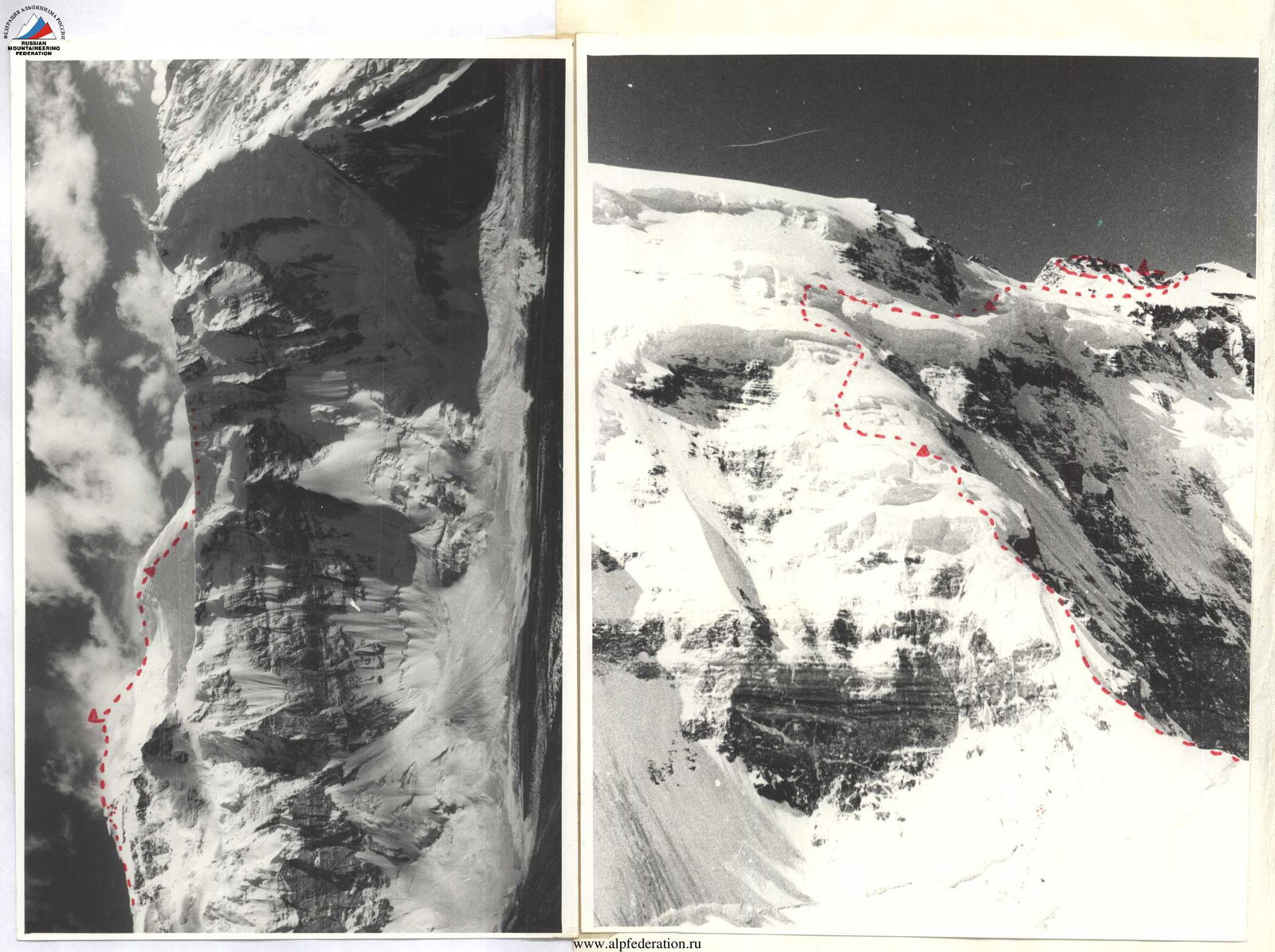
August 5, 1978. The group departed from the campsite at 6:00 and, moving along the right moraine of the Walter Glacier, approached the route in one hour. The lower part of the counterfort appears as a snow-ice cushion rising approximately 500 m above the glacier. After crossing the glacier, the group ascended via a talus slope to the right and approached the beginning of the snow-ice ridge, starting above the snow-ice cushion. The steepness of the couloir was 40–45°. They moved along the left edge of the couloir along the boundary between rocks and snow. Movement was simultaneous, with occasional turns, using ice screws for belays, and step cutting, wearing crampons. They reached the snow cushion, where they stopped for a meal and rest. From the snow cushion, they ascended to a sharp ice ridge with a steepness of 45–50°. Movement was alternating, using ice screws for belays. The first rope team reached the base of a rock wall along the lateral ridge. The rock wall, with a steepness of up to 75°, was heavily destroyed with sections of flow ice.
The entire group passed it without backpacks, which were then pulled up. Belays were hook belays, using "Jumar" ascenders. The wall led to a short, rubble ridge and further along a wide snow-ice ridge; the group approached the first ice ascent. The ice ascent appears as a sheer drop of the counterfort, and the ascent was made along the right slope, oriented northwest and covered with ice, where the ascent was carried out with step cutting. Along the ridge, movement was alternating, with hook belays upwards about one rope length; the route led to the upper part of the counterfort and further to section R7, representing an alternation of individual snow ascents with more gentle sections, where the group stopped for the night in a snow hollow.
Day III
August 6, 1978. From the campsite, the group began moving upwards along the ridge from the upper part of the counterfort. In some places on steep sections — ice. They encountered:
- crevasses,
- individual drops,
- which were bypassed.
Movement was mostly alternating, in some sections simultaneous, with belays via ice axe or ice screws. At an altitude of 6000 m — a relatively flat spot (15–20°). The weather was good, clear. Further movement was straight up the snow slope. They approached the firn drops encircling the shoulder of the Izvestia Peak. At this point, there is a passage to the right in the drops, leading to a snow slope with a steepness of 15–25°. The slope ends in drops below and is also limited above by a series of crevasses and drops. They moved up and to the right along this slope, towards the saddle between the Izvestia Peak and the 50th Anniversary of Komsomol Peak until 20:00, where they stopped for the night in a snow hollow between large seracs in the upper part of the slope.
Day IV
August 7, 1978. A morning reconnaissance showed that the firn drops above the slope were impassable. They then moved under the rocks of the Izvestia Peak's shoulder along their boundary with the drops. Upon reaching the rocks, they overcame a bergschrund using a rock bridge, from which they ascended a 5-meter vertical rock wall with a cleft, using hooks as footholds, and then moved up and to the right along icy rocks to a rocky shoulder, from where they reached snow slopes above the drops, descending directly from the saddle between the Izvestia Peak and the 50th Anniversary of Komsomol Peak. The slopes were steep, covered with ice and shallow snow. They reached the slope descending directly from the saddle between the Izvestia Peak and the 50th Anniversary of Komsomol Peak. Moving up and to the right along the slope, the group reached the ridge between the indicated peaks by 13:00. The snow on the slope was shallow, alternating with ice sections in places. Movement was alternating, wearing crampons, with belays:
- through ice axe,
- through ice screws.
Upon reaching the ridge, they approached the rocks at the beginning of the ascent to the 50th Anniversary of Komsomol Peak and stopped for a rest day. After lunch, moving under the summit tower along an inclined ice slope to the right and upwards along the direction of movement, they bypassed the 50th Anniversary of Komsomol Peak. The weather was good, clear. Movement was alternating, with belays:
- on snow sections — through ice axe,
- through rocks — via rope,
- on ice sections — through ice screws.
Having bypassed the summit tower of the 50th Anniversary of Komsomol Peak to the right, they reached rock ledges overhanging the Pamir Firn Plateau to the northwest. Along the destroyed rock ledges, they reached the saddle between the 50th Anniversary of Komsomol Peak and Peak Communism, where they stopped for a short rest around 17:00 on the camping sites of N. Chyorny's group in 1976. Then, they began the ascent along the northern ridge of Peak Communism to a height of 6900 m. The ridge is a chain of ascents with a steepness of 20–40°, alternating with more gentle sections. They moved along the talus on the right part of the ridge and along the snow on its left part. The snow was very dense. Movement was in crampons. The wide ridge allowed them to pass most of it without being tied together. The weather was good. At 20:00, the group stopped for the night on a talus ridge.
Day V
August 8, 1978. The morning was clear, with no wind. At 8:00, they began the ascent to the summit. Movement was along the northeastern ridge of Peak Communism. At 14:00, they approached the final ascent, a sharp snow ridge with a cornice towards the Bivachny Glacier. Here, they caught up with a group of climbers from Hungary and MAL instructors V. Tkach and V. Petiforov.
Moving alternately with belays through ice axes and rock outcrops, both groups reached the summit at 16:05. They retrieved a note from the Hungarian athletes' group. The weather was good. After taking photos on the summit, the group began descending along the ridge, following the ascent route to the saddle with a snow cornice. They started descending along the northwestern slope towards the Pamir Firn Plateau, in the direction of the Dušanbe Peak 6950 m. The descent to the saddle through deep, sinking snow was simultaneous. Overcoming two snow-ice ascents with a steepness of 20–30°, the group arrived at the Dušanbe Peak for the night.
Day VI
August 9, 1978. At 8:00, they began descending to the plateau from the Dušanbe Peak along the northwestern ridge. From 6950 m to 6400 m, they dropped 550 m in 30 minutes. Movement was simultaneous and alternating in rope teams. At a height of 6300 m, they met a trio of climbers from Poland.
At 11:00, they descended to the plateau, where they provided medical assistance to an injured climber from Czechoslovakia. After resting and having lunch at the "Vostok" station, they crossed the plateau longitudinally together with climbers from Hungary and Czechoslovakia and reached the Parashutist Peak by 20:00, where they spent the night.
Day VII
August 10, 1978. At 10:00, they began descending along the "Burevestnik" ridge, making a stop for rest on the Verblud Peak. At 19:00, having crossed the Fortambek Glacier, they arrived at the base camp of the "Pamir-78" MAL on Suloev Square.
Route Assessment
Based on the experience of previous ascents, the group assesses the route as 5B category of difficulty. The group compared it to the Borodkin route on Peak Communism. The route they passed is more complex than the aforementioned. Considering the complex snow-ice conditions this year, it is more dangerous than the Borodkin and Chyorny routes of 1976.
List of Equipment Taken by the Group for the Ascent
- Main ropes 2 × 40 m.
- Rock hammers — 2 pcs.
- Ice axes — 4 pcs.
- Various titanium rock pitons — 8 pcs.
- Ice screws — 6 pcs.
- High-altitude nylon tent — 1 pc.
- "Febus" primus stove — 1 pc.
- "Lastochka" radio — 1 pc.
- Gasoline — 8 liters.
- Pots 2 liters, 2.5 liters — 2 pcs.
- Carabiners — 15 pcs.
- Safety harness — 4 pcs.
- Crampons — 4 pairs.
The group was provisioned for 8 days at a rate of 450 g per person.
Table of Main Characteristics of the Ascent Route to Peak Communism from Walter Glacier

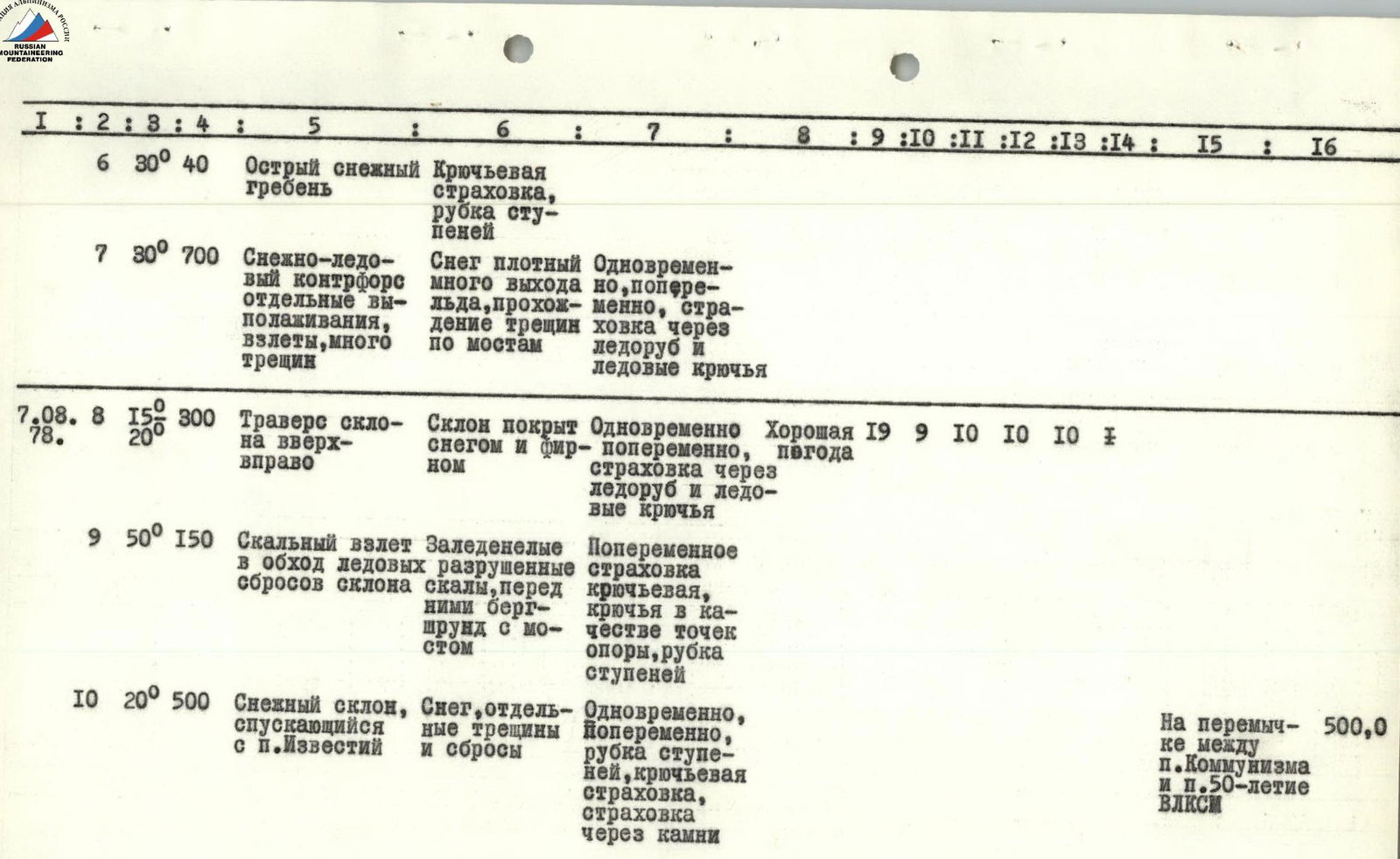
| Date | Section No. | Average Steepness | Length, m | Characteristics of Sections and Conditions of Passage | Method of Overcoming and Belays | Weather Conditions | Stop Time | Travel Hours | Pitons Hammered (Rock) | Pitons Hammered (Ice) | Pitons Hammered (Bolt) | Camping Conditions | Daily Ration Weight |
|---|---|---|---|---|---|---|---|---|---|---|---|---|---|
| 05.08.1978 | R1 | 40° | 600 | Snow-ice couloir. Movement along rocks, ice to the left of the couloir. | Simultaneous, some turns. Belays via outcrops, pitons. Alternating on crampons, step cutting. | Good weather | 18:00 | 12 | 3 | 3 | On a talus snow ridge | 700.0 | |
| R2 | 45° | 400 | Snow-ice ridge. | Alternating on crampons, step cutting. | |||||||||
| 06.08.1978 | R3 | 65° | 20 | Rock wall.6 | Rock wall. Steep, destroyed rocks, many loose stones. | Alternating, hook belays. | Good weather | 19:00 | 11 | 10 | 4 | Between large seracs | |
| R4 | 30° | 200 | Snow-ice ridge. Snow lying on ice holds well. | Simultaneous, alternating. | |||||||||
| R5 | 45° | 40 | Ice ascent. Steep ice with crevasses in the lower part. | Alternating with step cutting, hook belays. | |||||||||
| R6 | 30° | 40 | Sharp snow ridge. | Hook belays, step cutting. | |||||||||
| R7 | 30° | 700 | Snow-ice counterfort, individual flattening, ascents, many crevasses. Snow is dense, much ice exposed, passage of crevasses on bridges. | Simultaneous, alternating. Belays via ice axe and ice screws. | |||||||||
| 07.08.1978 | R8 | 15° | 300 | Traverse of slope up and to the right. Slope covered with snow and firn. | Simultaneous, alternating. Belays via ice axe and ice screws. | Good weather | 19:00 | 9 | 10 | 10 | 10 | ||
| R9 | 50° | 150 | Rocky ascent. Icy, destroyed rocks, bergschrund with a bridge before them. | Alternating, hook belays, hooks as footholds, step cutting. | |||||||||
| R10 | 20° | 500 | Snow slope descending from Izvestia Peak. Snow, individual crevasses, and drops. | Simultaneous, alternating. Step cutting, hook belays, belays via rocks. | On the saddle between Peak Communism and 50th Anniversary | 500.0 | |||||||
| 08.08.1978 | R11 | 45° | 100 | Rock ledges, towers on 50th Anniversary of Komsomol. Destroyed slate rocks, many loose stones. | Simultaneous, alternating. Belays via rock outcrops and stones. | ||||||||
| R12 | 30° | 120 | Northern ridge of Peak Communism and its shoulder. Wide ridge, alternation of talus and snow, individual rocks. | Simultaneous, some turns alternating. | Good weather | 18:00 | 10 | 8 | On the descent from the summit on the ridge of Peak Communism, height 6900 m | 500.0 | |||
| R13 | 10° | 200 | Northeastern ridge of Peak Communism. Gentle snow ridge with individual ascents. Dense snow. | Simultaneous. | |||||||||
| R14 | 25° | 200 | Pre-summit ridge. Sharp snow ridge with a cornice on Bivachny Glacier. | Alternating. Belays via ice axe, rock outcrops. |
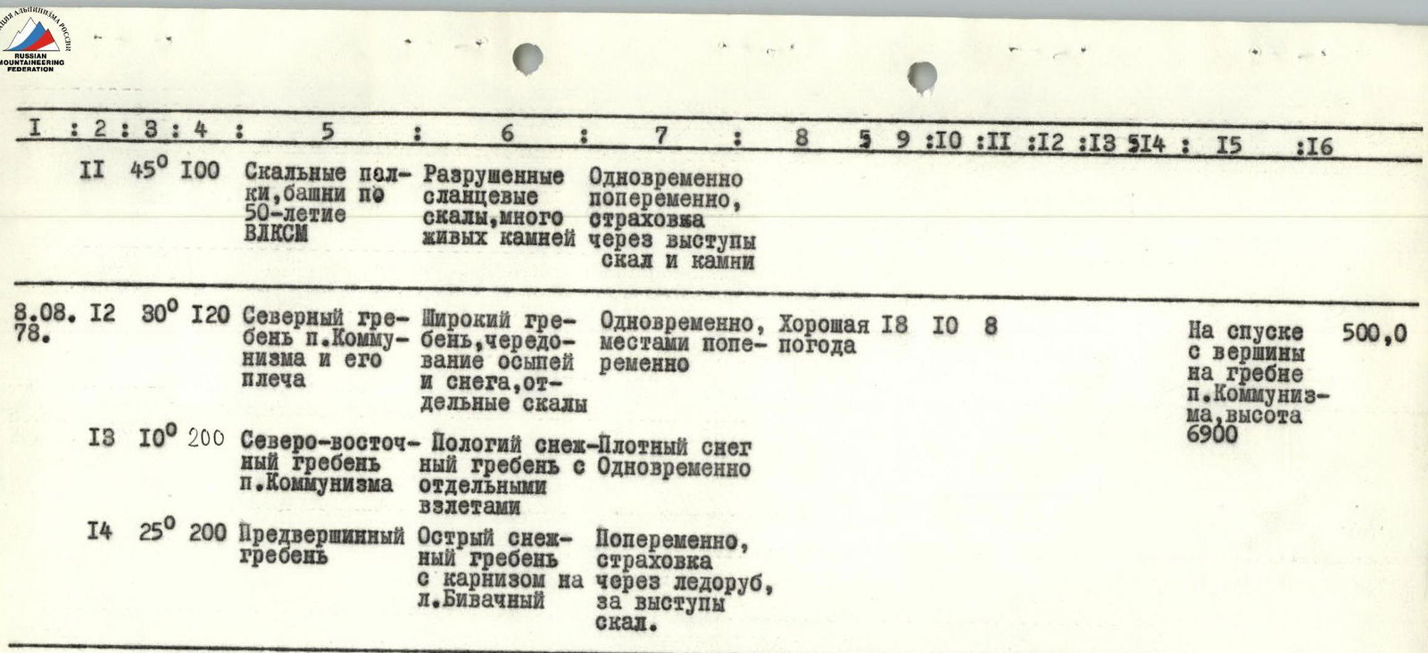
Total hammered:
- 30 ice screws
- 10 rock pitons