Ascent Passport
- Ascent class — high-altitude technical
- Ascent area — Pamir, Vanchsky Ridge.
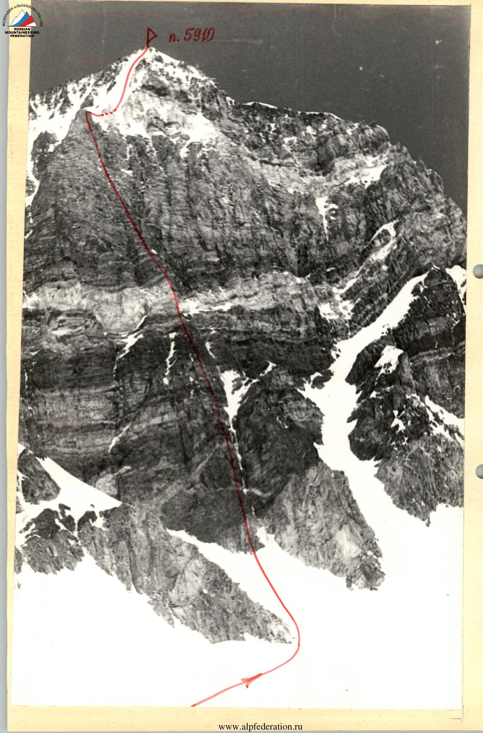
- Peak, its height, ascent route — p. 5910 m via the southern wall.
- Proposed difficulty category — 5B.
- Route characteristics: total altitude difference — 810 m. wall altitude difference — 610 m. length of sections with 5th cat. diff. — 260 m. 6th cat. diff. — 246 m. average steepness of the entire route — 67°. average steepness of the wall — 77°.
- Pitons hammered: for belaying, for creating ITO Rock: 68 (for belaying), 2 (for creating ITO) Ice: 6 (for belaying) Chocks: 27 (for belaying), 10 (for creating ITO)
- Total climbing hours — 27.
- Number of bivouacs and their characteristics: 2 bivouacs, one sitting on a rock shelf, the second on snow, comfortable.
- Surname, Name, Patronymic of the team leader, participants, and their qualification: team leader: SERPAK Alexander Alexandrovich, CMS participants: — GORBENKO Mstislav Mstislavovich, CMS — ZIMOV Valery Nikolaevich, CMS — OROBEI Igor Alexandrovich, MS — KHOLOPTSEV Alexander Vadimovich, CMS.
- Team coach — Sviridenko Vadim Sergeevich, MS, instructor-methodologist 1st cat. diff.
- Date of departure and return
July 23–25, 1980
II. Brief description of the approach to the route
The path to p. 5910 m passes through the Pyandzh river gorge, then along the Vanch river valley to the geologists' settlement "Dalniy Khrustalny". Then, via tourist and geological trails on either side of the Abdukagor glacier to the Abdukagor-I pass (10 hours).
From the pass, the southern wall of p. 5910 m is clearly visible. This black wall stands out against the backdrop of snow-covered Pamir peaks. From the pass, a large firn plateau leads to the wall with minimal elevation gain (2.5 hours).
III. Selection of the ascent object
This year's Odessa expedition, apart from its main goal — ascending Peak Revolyutsii — participation in the USSR Championship, set out to complete an ascent as part of the All-Union "Avangard" Sports Society Championship in the high-altitude technical ascents category.
Considering the experience and recommendations of the Odessa expedition in 1970, and the Leningrad and Rostov expeditions in 1979, two objects were identified in this area for ascent:
— the southern wall of peak 5910 m (east of Vysokiy Tanymas peak); — the western wall of peak Zlatoust.
Extensive work was done to detail the reconnaissance of these walls.
The western wall of peak Zlatoust has a good altitude difference but is dissected by ribs and couloirs, and the rock is not very solid, posing an objective rockfall hazard. The southern wall of peak 5910 is much steeper, the rock is clearly better (with many outcrops of light and dark granite), and allows for a safe route.
The southern wall of peak 5910 is fully visible from the Abdukagor-II pass and inevitably draws attention, standing out sharply against the white Pamir background with its blackness. 
On July 19 and 20, the team was under the southern wall of p. 5910 m. A bivouac was set up at a new campsite for this area — on the scree of the southern spur of Vysokiy Tanymas peak, an hour from the start of the route. The campsite was named "Odessa". It was convenient, with stone-lined platforms and water available. The wall was observed using binoculars. They made one exit directly under the wall and another to the southern spur of Vysokiy Tanymas peak for observation and photography of the wall profile.
The route was chosen as the shortest path to the peak via a steep counterfort that transitions into an overhanging wall (upper bastion) and then along a snow-ice slope to the summit. The route is logical, unambiguous, and safe, passing through relatively solid rocks (especially the upper bastion — monoliths). In our opinion, there is no second route on this wall that meets these requirements.
IV. Table of main route characteristics
| Date | Designation | Average steepness | Length, m | Terrain character | Difficulty | Condition | Weather conditions | Rock | Ice | Chocks |
|---|---|---|---|---|---|---|---|---|---|---|
| July 23, 1980 | R0–R1 | 40° | 60 | Snow slope | 2 | Firn | Good | — | Simultaneous via ice axe | — |
| R1–R2 | 50° | 60 | Snow-ice slope | — | Dense firn | — | — | via ice axe | — | |
| R2–R3 | 65° | 50 | Inner corner | 4 | Monolith | — | 3 | — | 5 | |
| R3–R4 | 75° | 20 | Wall | 5 | Destroyed | — | 3 | — | 2 | |
| R4–R5 | 80° | 70 | Wall | 6 | Monolith | — | 10 (+4 for ITO), "heavenly" pitons | — | 3 (+2 for ITO) | |
| R5–R6 | 50° | 15 | Couloir | 4 | Inflow ice | — | — | 3 | 1 | |
| R6–R7 | 90° | 45 | Wall | 5 | Monolith | — | 5 | — | 2 | |
| R7–R8 | 50° | 25 | Ridge | 4 | Destroyed | — | 1, via outcrop | — | — | |
| R8–R9 | 60° | 20 | Ridge | 4 | Destroyed | — | 2, via outcrops | — | — | |
| R9–R10 | 80° | 60 | Wall | 5 | Destroyed | — | 3 | — | 2 | |
| R10–R11 | 90° | 15 | Cleft | 6 | Destroyed | — | 3 (+1 for ITO) | — | 1 | |
| R11–R12 | 80° | 20 | Chimney | 5 | Destroyed | — | 2 | — | — |
Departure on the route at 6:30, stop for bivouac at 16:00. From 16:00 to 20:00, processing sections R9–R12 by a "double" team. Climbing hours — 12. Bivouac on a rock shelf — sitting.
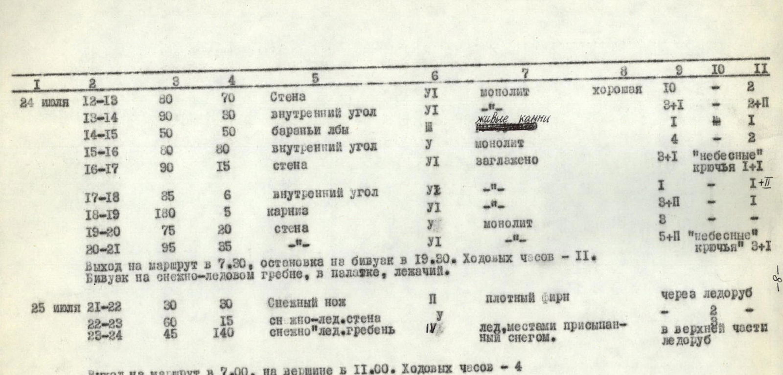
| Date | Designation | Average steepness | Length, m | Terrain character | Difficulty | Condition | Weather conditions | Rock | Ice | Chocks |
|---|---|---|---|---|---|---|---|---|---|---|
| July 24, 1980 | R12–R13 | 80° | 70 | Wall | 6 | Monolith | Good | 10 | — | 2 |
| R13–R14 | 90° | 80 | Inner corner | 6 | Loose rocks | — | 3 (+1 for ITO) | — | 2 (+2 for ITO) | |
| R14–R15 | 50° | 50 | "Sheep's foreheads" | 1 | — | — | 1 | — | — | |
| R15–R16 | 80° | 80 | Inner corner | 5 | Monolith | — | 4 | — | 2 | |
| R16–R17 | 90° | 15 | Wall | 6 | Smoothed | — | 3 (+1 for ITO), "heavenly" pitons | — | 1 (+1 for ITO) | |
| R17–R18 | 85° | 6 | Inner corner | 5 | — | — | 1 | — | 1 (+1 for ITO) | |
| R18–R19 | 180° | 5 | Cornice | 5 | — | — | 3 (+1 for ITO) | — | 1 | |
| R19–R20 | 75° | 20 | Wall | 5 | Monolith | — | 8 | — | — | |
| R20–R21 | 95° | 35 | Wall | 6 | — | — | 5 (+1 for ITO), "heavenly" pitons | — | 3 (+1 for ITO) | |
| Departure on the route at 7:30, stop for bivouac at 19:30. Climbing hours — 11. Bivouac on a snow-ice ridge, in a tent, lying down. | ||||||||||
| July 25, 1980 | R21–R22 | 30° | 30 | Snow knife-edge | 2 | Dense firn | — | — | via ice axe | — |
| R22–R23 | 60° | 15 | Snow-ice wall | 5 | — | — | — | — | — | |
| R23–R24 | 45° | 140 | Snow-ice ridge | 4 | Ice, partly covered with snow | — | — | in upper part via ice axe | — |
Departure on the route at 7:00, on the summit at 11:00. Climbing hours — 4.
V. Brief explanations for the table
July 23. Departure on the route at 6:30. The route along the southern wall of p. 5910 is bounded on the right by a steep couloir filled with ice. The ascent begins 40 meters to the left of the couloir.
Along a steep snow-ice slope through a snow-filled bergschrund — approach under the wall to the light granites.
The first participant is in crampons. Along an inner corner (R2–R3), which becomes steeper higher up, upwards to the right under the first cornice. The cornice is traversed on the right using ladders. Rucksacks are pulled up using the American method. Here and further until the end of the wall, the first climber goes without a rucksack.
Further, the wall with few handholds leads to a chimney with an overhang 10 meters high, transitioning into an inner corner. This section of the wall (R4–R5), 70 m long, with an average steepness of 80°, is very complex, requiring the use of ladders not only when traversing the cornice but also on other elements of the rock relief.
Movement in the chimney with a rucksack is impossible, so here is the only place where rucksacks were pulled up using the conventional method.
After the wall — exit into a couloir with inflow ice (R5–R6), from it — onto a destroyed ridge leading under a sheer wall (R7–R8). The wall is overcome via a cleft and leads to a destroyed ridge. Along the ridge (R8–R9) — straight up under the quartz belt. Time — 16:00.
The only place on the wall where a normal sitting bivouac can be organized. Prepared in 3 hours. A. Serpak and A. Kholoptsev worked ahead.
"Double" team: V. Zimov and A. Kholoptsev processed another 3 difficult rope lengths of the quartz belt. Sections R9–R12. Returned by 20:00.
The rock is fragile, and the climbing is very tense, using large channel and ice pitons for belaying.
The belt is overcome: — along the wall (R9–R10) with a general direction from left to right towards the cleft; — then along the cleft (R10–R11) — straight up to a small inclined shelf at the base of the chimney; — along it — straight up under the overhanging live blocks of dark rocks and through them — exit to a narrow shelf at the base of the wall (R12–R13).
July 24. Departure on the route at 7:30. After the fixed ropes, M. Gorbenko works ahead.
The wall is traversed straight up via very small handholds. There are few cracks for piton placement. "Heavenly" pitons are used successfully here.
The wall becomes steeper in its upper part and leads under destroyed overhanging rocks. Under them — a traverse to the right under the base of the overhanging inner corner (R13–R14). Along it, we move upwards. In the upper third of the corner, we transition to the right wall with a wide crack and further — to an outcrop under the wall. Along the wall — left and upwards to a narrow shelf.
Along a couloir filled with snow — approach to the key sections of the route — the bastion of the wall.
The bastion overhangs (average steepness not less than 95°). Huge icicles occasionally break off and fly over our heads (like on the bastion of South Ushba).
Along large-block rocks with overhangs — exit into a huge inner corner "book" (R15–R16).
Along the corner 5 meters up and a traverse along the sheer wall of the "book" — to the left. Straight up, overcoming small cornices and overhangs — exit to a platform — a balcony sized 0.5 × 1 m. A convenient place for belaying.
Further — a 6-meter inner corner (R17–R18), closed from above by a huge cornice — "roof" (R18–R19). The cornice is overcome "head-on" (ladders) and along steep rocks (R19–R20) — to a shelf, from which 35 meters along a smoothed overhanging wall — exit to the ridge. Time — 19:30.
Bivouac on snow, platforms for a tent. Climbing hours — 11.
July 25. Departure on the route at 7:00. I. Orobei works ahead. A snow-ice ridge leads to the summit. Crampons and ice pitons are necessary. A snow knife-edge (R21–R22) abuts a 20-meter light-brown rock sentinel "Old Man". The sentinel is bypassed on the left along a steep ice wall (R22–R23). Along the wall, we exit to the pre-summit snow-ice ridge. Along it — to the summit. Time — 11:00. Climbing hours — 4. The summit is a snow dome, dropping off with cornices to the east towards led. Fedchenko. A cairn is built on small rock outcrops 15 meters west of the summit.
Descent along the snow-ice south-eastern ridge towards p. 5430 m. The first and last are always in crampons. From the saddle between p. 5910 m and p. 5430 m — descent to the right along the icefall onto led. Fedchenko. On steep sections, 3 rappels of 80 meters each are organized. Descent to led. Fedchenko took 6 hours.
VI. Equipment table
| № | Name | Quantity | Used on section | Total weight |
|---|---|---|---|---|
| 1 | Main rope (UIAA) — 42 m | 1 | R2–R21 | 2.5 |
| 2 | Main rope VTsSPS — 40 m | 4 | R1–R24 | 10.0 |
| 3 | Reepschnur 25 m | 1 | — | 0.7 |
| 4 | Carabiners | 60 | R2–R24 | 6.3 |
| 5 | Rock pitons | 50 | R2–R21 | 5.7 |
| 6 | Ice pitons VTsSPS | 3 | R5–R6, R23–R24 | 0.6 |
| 7 | Ice axes | 4 | R22–R23 | 0.3 |
| 8 | "Heavenly" pitons | 2 | R4–R5, R16–R17, R20–R21 | 0.1 |
| 9 | Chocks — set | 15 | R2–R5, R7–R8, R9–R11; R12–R19, R20–R21 | 1.0 |
| 10 | Rock hammers | 2 | R2–R21, R23–R24 | 1.8 |
| 11 | Ice axes | 4 | R1–R2, R21–R24 | 6.0 |
| 12 | Ice pick | 1 | R1–R2; R5–R6; R21–R24 | 1.2 |
| 13 | Ladders | 6 | R4–R5, R10–R11; R13–R14; R16–R19; R20–R21 | 0.9 |
| 14 | Platforms | 1 | — | 1.5 |
| 15 | Drill | 2 | — | 0.1 |
| 16 | Bolt pitons | 15 | — | 0.2 |
| 17 | Extensions | 15 | R2–R21 | 0.8 |
| 18 | Crampons | 2 | R0–R2; R21–R24 | 3.0 |
| 19 | Gas burner with 2 cylinders | 1 | R9–R10, R21–R22 | 1.5 |
| 20 | Radio station "Nedra" | 1 | during communication hours | 2.0 |
| 21 | Pamirka tent | 1 | R9–R10; R21–R22 | 4.0 |
| 22 | Medical kit | 1 | — | 0.8 |
| 23 | Cameras | 2 | filming on the route | 2.0 |
| 24 | Down sleeping bag | 3 | R9–R10, R21–R22 | 4.5 |
| 25 | Down jacket | 5 | R9–R24 | 4.0 |
| 26 | Down "leg" | 2 | R9–R10; R21–R22 | 0.8 |
| 27 | "Truba" rucksack | 5 | R0–R24 | 3.5 |
| 28 | Helmet | 5 | R0–R24 | 2.5 |
| 29 | Belay harness | 5 | R0–R24 | 2.5 |
| 30 | "Vibram" type boots | 5 | R0–R24 | 7.5 |
| 31 | Galoshes | 3 | R2–R21 | 1.2 |
Total for a group of 5 — 68.5 kg
Sr. coach Sviridenko V. S.
Team captain Serpak A. A.


