Ascent Log
- Type of ascent: High-altitude technical climb.
- Region of ascent: Central Pamir, Yazgulemsky Range, Peak Sentyabrsky (Szent-Ekzyuperi) northwest of the Abdukagor-2 pass.
- Peak, its height, ascent route: Peak Sentyabrsky (Szent-Ekzyuperi), 6063 m, combined route via the left edge of the western wall.
- Estimated difficulty category: 5B.
- Route characteristics: Height difference 1160 m, average steepness up to the summit ridge 54°. Length of sections with 6th category complexity — 50 m, 5th category complexity — 500 m, 4th category complexity — 800 m, 3rd category complexity — 300 m.
- Number of pitons hammered:
For belaying and creating artificial holds
rock — 30 ice — 87 bolts — 6
- Number of climbing hours: 26.
- Number of bivouacs and their characteristics: total bivouacs — 3; 1 — after the icefall at the base of the wall in a tent; 2 — on a shoulder above the triangle in a tent; 3 — on the descent beyond the summit in a tent.
- Surname, name, patronymic of the group leader, participants, and their sports qualification:
- Trasevich Alexey Ivanovich — Candidate for Master of Sports of the USSR.
- Mazarchuk Mikhail Alexandrovich — Candidate for Master of Sports of the USSR.
- Nedosekova Svetlana Stepanovna — Candidate for Master of Sports of the USSR.
- Platkov Valery Yakovlevich — Candidate for Master of Sports of the USSR.
- Cherevko Vladimir Leonidovich — Master of Sports of the USSR.
- Forostyan Vitaly Yuryevich — Master of Sports of the USSR.
- Team coach: Master of Sports of the USSR, Honored Coach of the Ukrainian SSR Polevoy Grigory Vladimirovich.
- Date of departure on the route and return: July 10–13, 1979.
Peak Sentyabrsky (Szent-Ekzyuperi) (6063 m) is located in the Yazgulemsky Range northwest of the Abdukagor-2 pass and is one of the most beautiful and attractive peaks in the region from an alpinist's perspective. Until now (apparently due to inaccessibility), only one route of 4A category difficulty had been laid to the summit via the Southern ridge.
To the west, Peak Sentyabrsky (Szent-Ekzyuperi) drops off with a sheer wall. In 1976, a sports group from the Chelyabinsk Mountain Sports Committee attempted a first ascent via the left part of the wall but remained unsuccessful for several reasons. However, the ascent participants unanimously stated that the route, although difficult (approximately 5B category), is logical and entirely passable with proper preparation.
Indeed, preliminary observation of the wall revealed a logical path along the left edge of the western wall, on the border between rock and ice, leading to the steep western ridge and further along the summit ridge to the peak. The center and right part of the wall appear dangerous to traverse as, despite their great steepness, they are much more destroyed. The first ascent via the left edge of the western wall was achieved by a group from the Ukrainian SSR Sports Committee:
| Trasevich A. I. | — leader, Candidate for Master of Sports of the USSR |
|---|---|
| Mazarchuk M. A. | — participant, Candidate for Master of Sports of the USSR |
| Nedosekova S. S. | — participant, Candidate for Master of Sports of the USSR |
| Platkov V. Y. | — participant, Candidate for Master of Sports of the USSR |
| Forostyan V. Y. | — participant, Master of Sports of the USSR |
| Cherevko V. L. | — participant, Master of Sports of the USSR. |
The nearest alpine base (very remote) — "Varzob" tourist center. The group left the expedition's base camp of the Ukrainian SSR Sports Committee on July 10 at 6:30 and approached the start of the route by 11:00. On the same day, the lower, simpler part of the route was traversed (icefall to the bergschrund). The ascent was completed in full composition from July 10 to 13, 1979. Weather conditions were good.
Brief description of the approach to the route
From the settlement of Khrustalny, follow up the gorge along the road crossing the Medvezhy Glacier in the direction of the Abdukagor Glacier. The road leads to a helicopter pad located 30 minutes' walk from the start of the glacier. From the settlement to the helicopter pad is about 3 hours. Then, follow the left (in the direction of travel) side of the river, gaining height along the talus, leaving the "tongue" and lateral moraine of the glacier to the right. The path follows a trail that sometimes disappears. About 2 hours into the journey, the glacier turns west (i.e., left in the direction of travel) towards the Abdukagor pass. Move in the direction of the pass along the left (in the direction of travel) part of the glacier. Crevasses! As you advance and ascend towards the pass, the pass itself comes into view, and to its left, the peak — Sentyabrsky (Szent-Ekzyuperi) with its characteristic dark, sheer western wall. From the glacier's bend to the start of the route is about 2 hours.
Route description
Follow the left part of the Abdukagor Glacier towards the characteristic sheer western wall of Peak Sentyabrsky (Szent-Ekzyuperi). The route begins with a steep (up to 50°) ice slope, cut by wide crevasses, which adjoins the western wall in its left part (section R0–R1 according to Table 1). At the base of the wall, the slope becomes gentler, forming a small plateau in the cirque of peaks: Peak Bespokojny — Peak Sentyabrsky (Szent-Ekzyuperi). A convenient bivouac site can be set up on this gentler slope. From the start of the route to the bivouac site is about 4 hours. The western wall is bounded on the left by a wide and steep ice couloir, intersected in its lower part by a bergschrund. From the bivouac, move up the right part of the couloir to the bergschrund, ice at 45°, 100 m (section R1–R2). The bergschrund is overcome via a very unreliable snow bridge (careful belay!). Further up, ascend the ice slope (50°) with occasional exits onto rocks (where convenient), towards a small rock outcrop closely adjacent to the rock massif of the wall, in the part of the couloir where it gradually narrows and becomes steeper (section R2–R3). Belay using pitons on ice and rock. From the bergschrund to the rock outcrop is about 200 m. An early departure from the bivouac is recommended as the ice slope is sometimes exposed to falling rocks. From the rock outcrop, ascend directly upwards along the boundary between "ice and rock". The steepness of the ice is about 60°, the rocks to the right are occasionally overhanging, which, however, does not hinder belaying in many places via rock pitons. Belay positions can be conveniently chosen under overhanging rocks, providing protection from falling stones. After about 100 m, the edge of the rocks gradually begins to veer to the right. A 200-meter ice wall (60°) comes into view, leading to a shoulder on the steep western ridge (section R4–R5). On the shoulder of the ridge, there is a convenient site for a bivouac. From the first bivouac site below the bergschrund, it takes 12–14 hours. From the bivouac on the shoulder, ascend directly upwards along the right boundary of "rock and ice" on the western ridge, first for 100 m with a steepness of about 45° (section R5–R6), then more steeply for about 200 m — with ice steepness and rock inclusions up to 60° (section R6–R7), and finally, in the upper part, the ice upon exiting onto the summit ridge reaches 70° (last 50 m, section R7–R8). Then, ascend leftwards and upwards, with a slight gain in height, towards the summit along a rather complex ice-and-snow ridge, about 400 m (section R8–R9). Cornices! From the bivouac site to the summit takes 8–10 hours. The descent is via the southern ridge, category 4A difficulty. On the descent, there are many convenient platforms for overnight stays.
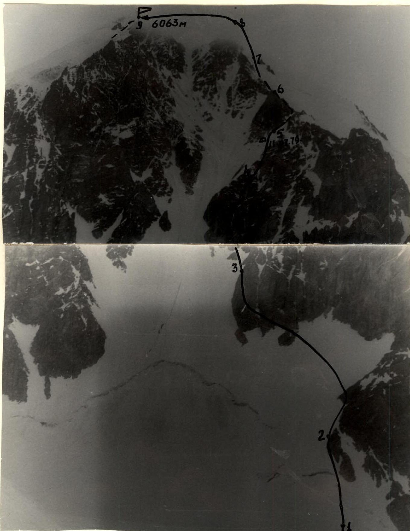
Photo 1. Photo of the peak from the base to its height.
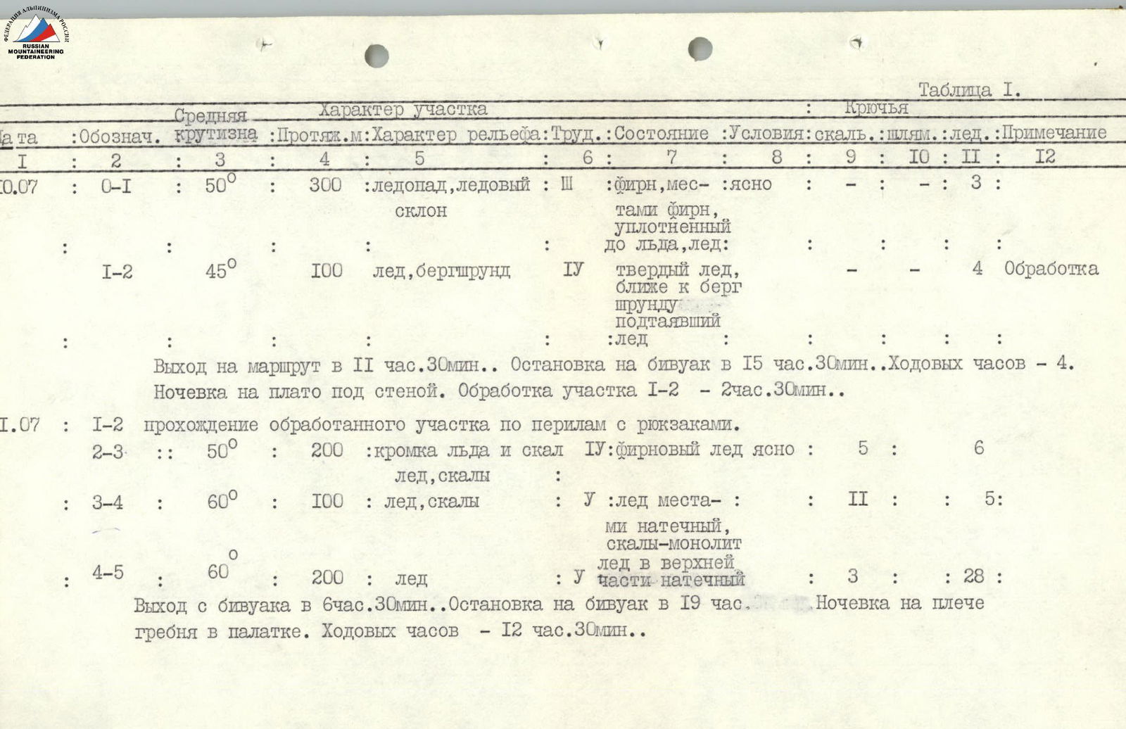
Table 1
| Date | Section | Steepness | Length (m) | Terrain | Difficulty Category | Condition | Weather | Rock Pitons | Bolt Pitons | Ice Pitons | Remarks |
|---|---|---|---|---|---|---|---|---|---|---|---|
| July 10 | R0–R1 | 50° | 300 | Icefall, ice slope | 3 | Firn, местами фирн, уплотненный до льда, лед | Clear | — | 3 | ||
| R1–R2 | 45° | 100 | Ice, bergschrund | 4 | Hard ice, closer to bergschrund, thawed ice | 4 Processing | |||||
| Departure onto the route at 11:30. Stop for bivouac at 15:30. Climbing hours — 4 hours. Overnight at the plateau under the wall. Processing of section R1–R2 — 2 hours 30 minutes. | |||||||||||
| July 11 | R2–R3 | 50° | 200 | Edge of ice and rocks, ice, rocks | 4 | Firn ice, clear | 5 | 6 | |||
| R3–R4 | 60° | 100 | Ice, rocks | 5 | Ice местами натечный, скалы-монолит | 2 | 5 | ||||
| R4–R5 | 60° | 200 | Ice | 5 | Ice in the upper part is wet | 3 | 28 | ||||
| Departure from bivouac at 6:30. Stop for bivouac at 19:00. Overnight on the ridge shoulder in a tent. Climbing hours — 12 hours 30 minutes. | |||||||||||
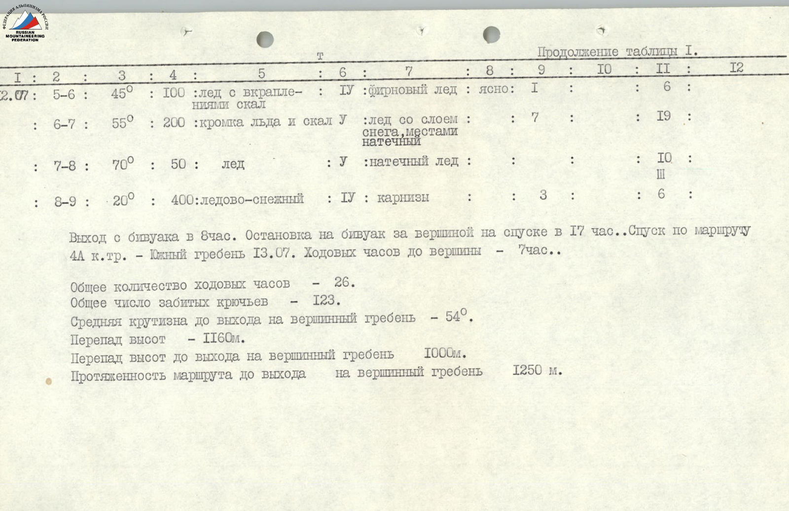 |
Continuation of Table 1
| Date | Section | Steepness | Length (m) | Terrain | Difficulty Category | Condition | Weather | Rock Pitons | Bolt Pitons | Ice Pitons | Remarks |
|---|---|---|---|---|---|---|---|---|---|---|---|
| July 12 | R5–R6 | 45° | 100 | Ice with rock inclusions | 4 | Firn ice | Clear | 1 | 6 | ||
| R6–R7 | 55° | 200 | Edge of ice and rocks | 5 | Ice with a layer of snow, местами натечный | 7 | 19 | ||||
| R7–R8 | 70° | 50 | Ice | 5 | Wet ice | 10 | 3 | ||||
| R8–R9 | 20° | 400 | Ice-and-snow | 4 | Cornices | 3 | 6 |
Departure from bivouac at 8:00. Stop for bivouac beyond the summit on the descent at 17:00. Descent via the 4A category route — the Southern Ridge on July 13. Climbing hours to the summit — 7 hours.
Total climbing hours — 26. Total number of pitons hammered — 123. Average steepness up to the exit onto the summit ridge — 54°. Height difference — 1160 m. Height difference up to the exit onto the summit ridge — 1000 m. Route length up to the exit onto the summit ridge — 1250 m.