Ascent
to the peak Russia via the Southeast ridge (first ascent) by the team of Moscow City Council of the DSO “Spartak”
Central Pamir, 1972
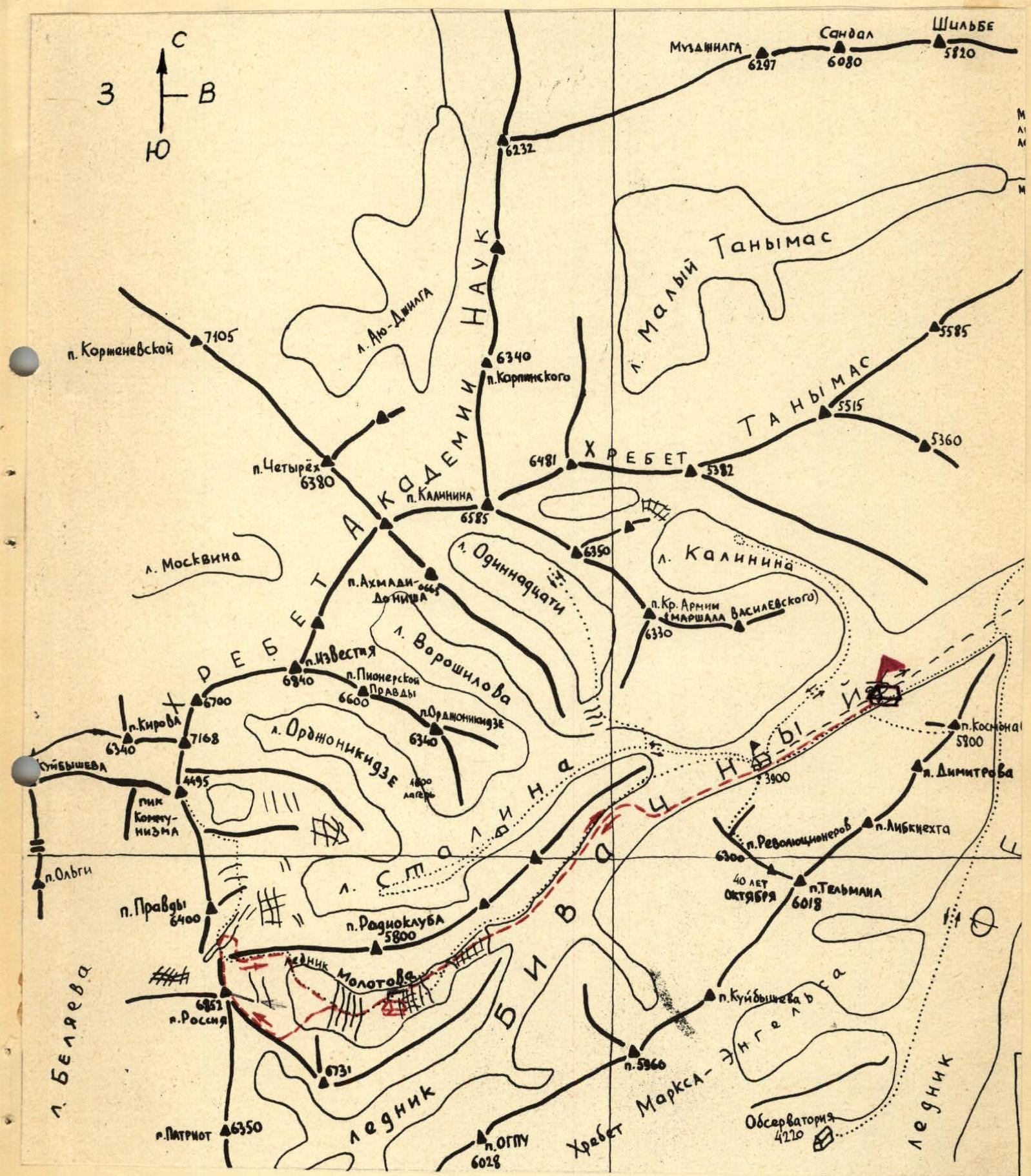
Map of the area
From August 1 to 10, 1972, the Central Council of the Spartak society conducted an expedition of climbers in the area of Peak Communism. Due to a delay in the helicopter, the expedition found itself in a very difficult situation, as the valleys of the Muksu and Sauk-sai rivers with numerous tributaries presented a serious obstacle even for a caravan, let alone the transportation of goods by people. The caravan did not have the necessary number of horses, and time was clearly insufficient. Transporting five hundred kilograms of food and equipment by horse to the confluence of the Bivachny and Fedchenko glaciers for an expedition of over fifty people did not change the situation much.
The base camp on the Bivachny glacier (3900 m) was only established on July 24, and the route planned for the USSR championship had to be changed. A new route, never before attempted, was chosen - the Southeast ridge of Peak Russia (6852 m).
Brief characteristics of the area
The Central Pamir is bounded to the north by the Muksu River and to the south by the Bartang River. To the east, the area is bounded by the Zulumart range, and to the west by the western spurs of the Petra Pervogo and Darvaz ranges, as well as the Pyanj River near Khorog. The relief of the Central Pamir is heavily dissected. It is home to:
- the highest ranges in the USSR;
- peaks;
- powerful glaciers.
Most of the ranges in the area have a latitudinal direction. The northernmost of these is the Petra Pervogo range, followed by the Darvaz range to the south, and then the Vanch and Yazgulyam ranges, with the impressive Peak Revolyutsii (6974 m), the fourth highest peak in the Pamir, which has been a frequent target for ascents in the USSR championship.
All the aforementioned ranges are connected to the east by the very high, meridionally oriented Akademii Nauk range, along which the Fedchenko glacier flows northward - the longest valley glacier in the world (71 km).
Peak Russia (6852 m) is the third highest peak in the Akademii Nauk range, located at the junction of the Petra Pervogo and Akademii Nauk ranges.
Near Peak Russia, separated from it by a firn plateau (6200 m) and Peak Pravdy (6406 m), stands Peak Communism (7495 m) - the highest peak in the Pamir and the USSR.
The summit of Peak Russia was first reached from the firn plateau (6200 m) by a group led by I. Gvarliani from the Georgian Alpine Club's expedition in 1955, which aimed to conquer Peak Communism via the southern ridge.
Organizational and tactical plan
I. Organization of interaction and communication.
For the main part of the route, starting from the camp at 5200 m, the Moscow City Council (MGS) group planned to take 7 days. Direct interaction was planned with a group of climbers from the Moscow section of alpinism, led by V. Klimashin, who were to ascend Peak Communism via the route of E. Tamm.
The departure times of both groups were planned so that, in addition to radio communication:
- visual observation;
- interaction on the initial section of the ascent;
- interaction during the descent from Peak Russia by the MGS group.
Meanwhile, along with the MGS team, participants from the Central Council of the DSO Spartak expedition set out on their routes. The Leningrad Spartakovites team aimed for Peak Communism, while the combined team from Alma-Ata and Kabardino-Balkaria targeted Peak OGPU.
At the base camp on the Bivachny glacier, a group led by Honored Master of Sports N.A. Gusak coordinated communication with the teams and observation groups.
Leaders of the teams and observation groups had a schedule for main and emergency radio communication, as well as communication by flares, which allowed constant monitoring of the location of all sports groups and the ability to provide necessary assistance quickly if needed.
II. Organization of the base camp and transportation of goods to the start of the route.
By the time the helicopter began operating, i.e., by July 23, the situation was as follows. Most of the food and equipment remained in Daraut-Kurgan, while the expedition participants were in Altyn-Mazar with some provisions. In anticipation of the helicopter, active acclimatization was carried out, including training ascents to a peak over 5000 m - Peak Rogova.
July 23-25:
- Establishment of the base camp on the Bivachny glacier (3900 m);
- Transportation of goods by helicopter.
Team members: Yu. Piskulov, O. Abalakov, V. Koprov.
July 25:
- Departure from the base camp to establish an intermediate camp at 5200 m;
- Receipt of cargo dropped by helicopter;
- Tasks included reconnaissance, observation, and preliminary clarification of route details.
July 26:
- O. Abalakov's group reached the foot of Peak Russia;
- Establishment of an intermediate camp under the first step of the Molotov glacier's icefall on the left moraine (orographically) at an altitude of 5200 m.
The main part of the team and V. Klimashin's group left the base camp and, moving along the left side of the Bivachny glacier, reached the area where the glacier turned into a chaos of seracs and ice walls. They then crossed the glacier and approached the confluence of the Molotov and Bivachny glaciers along the right side. By this time, the weather had deteriorated significantly, with wet snow falling, and they decided to set up camp despite the relatively early hour (16:00).
July 27. In the morning, O. Abalakov's group observed the dropping of cargo from the helicopter and organized a food depot. Then, after a second breakfast, they ascended to the first step of the Molotov icefall, from where they observed the Southeast ridge of Peak Russia.
In the afternoon, the weather began to deteriorate rapidly, and the group members descended to the 5200 m camp, where the rest of the team and V. Klimashin's group were arriving.
During the ascent along the ledge between the Molotov glacier and the "pyramid," special attention was paid to the possibility of rockfall from the "pyramid," but this danger seemed to be greatly exaggerated.
At 19:00, they held a celebratory dinner to mark the successful delivery of cargo and the reunion of the team.
For the next morning, they planned a light resupply of food (6 kg per person) to 6500 m and a return to the 5200 m camp.
July 28. A sunny morning found them at the foot of the first step of the icefall. V. Kavunenko and O. Abalakov went ahead, carefully choosing their path. The backpacks were light, and morale was high. After 3 hours of work, the first step of the icefall was passed (section R1).
After a 40-minute rest and tea, they moved along the snow-ice plateau towards the snow cushion under the Southeast ridge of Peak Russia (section R2). They established a temporary food depot, observed the summit, and clarified the route.
Initial options for the route passage, such as going straight up the rocks or bypassing the lower rock island to the right, were discarded due to rockfall and avalanche hazards.
They decided to bypass the lower rock island to the left along a steep ice-snow slope where there were no signs of rockfall or avalanches, and the lower part of the slope had been cleared by a recent avalanche.
Having made this decision, they began their descent back to 5200 m and were back in camp within two hours, where V. Klimashin's group was waiting, having just completed a resupply to the second step of the Molotov glacier's icefall.
III. Ascent plan by days
1st day - camp 5200 m - resupply to 5600 m. 2-7th day - passage along the ridge, reaching the summit. 8-10th day - reserve for bad weather. 11-12th day - descent and return to the 5200 m camp.
IV. Equipment preparation
Titanium equipment was used on the route. A diverse set of rock and ice pitons and wedges ensured reliable belays on all sections of the route. On the most complex sections of rock and ice relief, ladders, jammers, and self-braking blocks were used for pulling up backpacks.
Potential camping sites were chosen after prolonged observation of the route and were selected with maximum safety in mind.
Two "Pamirka" tents were taken on the route. For a group of 8 people, 160 m of rope (4 × 40 m) was taken, allowing for autonomy and speed in the work of the rope teams on the route. Much attention was given to the participants' equipment. All participants had insulated boots such as "Vibram" or "Shaklton," fitted with trikon spikes.
Equipment used
Group:
- "Pamirka" tents - 2 pcs.
- Main rope 40 m - 4 pcs.
- Auxiliary rope 5 m - 8 pcs.
- Ladders - 2 pcs.
- Block-brake - 1 pc.
- 4-seat down sleeping bag - 2 pcs.
- Belay harness - 8 pcs.
- Carabiners (titanium) - 30 pcs.
- Rock pitons (titanium) - 30 pcs.
- Ice pitons, screw and tubular, titanium - 10 pcs.
- Ice axes - 8 pcs.
- Rock hammers - 2 pcs.
- Petrol stoves - 2 pcs.
- Saucepans - 2 pcs.
Personal:
- Down suit - 8 pcs.
- Woolen underwear - 8 sets.
- Underpants - 8 pcs.
- Woolen sweater - 8 pcs.
- Down mittens - 8 pairs.
- Woolen mittens - 8 pairs.
- Helmets - 8 pcs.
- Sunglasses - 9 pairs.
- "Vibram" boots - 4 pairs.
- "Shaklton" boots - 4 pairs.
- Crampons - 8 pairs.
Nutrition
When selecting products, the group was guided by the individual tastes and preferences of the participants. The food was high-calorie (up to 4000 kcal per day), easily digestible, and vitamin-enriched. A significant part of the ration consisted of dehydrated products - meat, vegetables, soups, cottage cheese, etc. The weight of the daily ration was 450-600 g per person. The group had a supply of food for 12 days, including the resupply to the snow plateau at 5600 m.
Group composition
The team has extensive experience in ascents in the Pamir and Caucasus, including ascents of the highest difficulty category. Initially, a storming group of 10 people was planned, but two members were unable to start the route:
- G.S. Kainov was called to Moscow by telegram;
- D.A. Filippov fell ill.
Thus, the group started the route with 8 people.
| № | Full Name | Year of birth | Sports rank | DSO | Insurance certificate № | | : | :----------------- | :----------- | :---------- | :--------- | :---------------------- | | 1. | Kavunenko V.D. | 1935 | MSМК | “Spartak” | — | | 2. | Abalakov O.V. | 1938 | MS | — | — | | 3. | Piskulov Yu.V. | 1933 | MS | — | — | | 4. | Koprov V.M. | 1938 | MS | — | — | | 5. | Gumenyuk V.A. | 1937 | MS | — | — | | 6. | Zayd P.S. | 1935 | CMS | — | — | | 7. | Asfendiarov Z.Kh. | 1937 | CMS | — | — | | 8. | Smirnov E.G. | 1940 | CMS | — | — |
All participants in the summer season of 1971 completed an ascent of category 5B difficulty or an ascent for the USSR championship.
Route description
July 29. At 6:00, they left the 5200 m camp. The weather was excellent. Backpacks were heavier than the day before, but they were already on a familiar path, following the steps they had made the previous day.
Having ascended to the upper part of the icefall, they took a rest. It was very warm, even hot, with practically no air movement. They removed their clothing and took a 10-minute sunbath.
By 12:00, they approached the food depot, trampled down a platform in the snow, and set up tents. After lunch, two pairs - Kavunenko-Asfendiarov and Abalakov-Piskulov - went to process the lower part of the ice-snow slope, while the others clarified the details of the route passage and potential camping sites.
Having processed the lower part of the ice-snow slope up to the ice ledges (section R3), the foursome returned to camp at 16:00 to rest properly before the next day.
July 30. The morning was unpleasant. The sky was clear, but there was a very strong wind, with drifting snow, and it was cold. They dismantled the iced-up tents and began their ascent along the snow-ice slope, following the barely visible tracks from the previous day, moving up to the left of the lower rock island of the ridge (section R3). The tracks here became more distinct, and the wind somewhat subsided.
It was quite steep, but the snow was good and dense, with the ice axe sinking in up to the head. Ahead, the walls of ice ledges appeared, going up in steps (section R4).
They passed these, traversing to the right and left, and then, overcoming short steep sections head-on with the use of ice pitons and ladders, they reached a smooth section of the ice-snow slope (section R5).
The weather began to deteriorate: cirrus clouds appeared in the sky, a strong wind blew, and snow charges were being blown away.
Ahead loomed a massive ice wall, which was easily bypassed on the left. Under it was a small depression. Around the corner, they couldn't see suitable places for camping. It was 16:00, and they decided to camp under the wall. The wall was slightly overhanging. They chopped out ice, expanding the depression for the tents. Preparing the platforms took 2 hours.
After dinner, V. Kavunenko felt unusually tired, complaining of a poor appetite. They went to sleep in relatively comfortable conditions (6000 m).
July 31. In the morning, it became clear that Volodya Kavunenko would not be able to continue the ascent. He had a high temperature, headache, and throat pain. They sent Volodya down accompanied by doctor V. Gumenyuk.
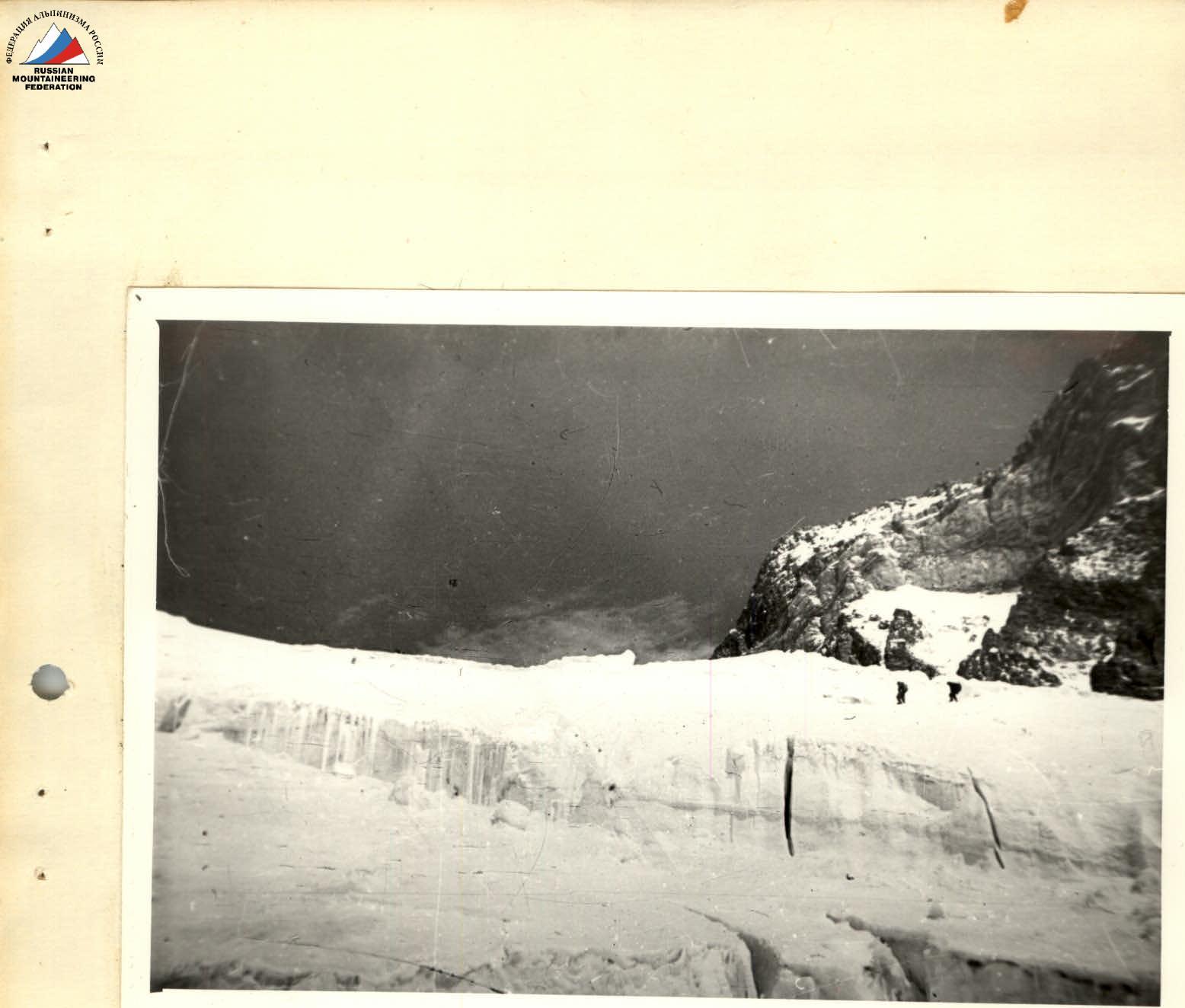
They were left with six people. They packed up the camp and around 9:00 began their ascent along the ice-snow slope, heading towards the pass between the rock island and the continuation of the ridge (section R6), to a practically vertical section that looked like a very wide internal angle filled with snow (with piton insurance).
Having overcome the internal angle (7 m) along a trench dug in the snow and pulled up their backpacks, they approached an ice crevasse with a steep upper edge. The first person crossed it without a backpack, the rest followed along the fixed ropes.
The further path was clear - an ascent along the snow-ice slope to the pass (section R7). As they moved up, the slope became steeper, and the snow layer on the ice thinner; O. Abalakov led the way.
Insurance was provided using ice pitons, and near the boundary with the rocks, rock pitons were used. They reached the pass and settled on top of the rock island. Pasha Zayd prepared tea.
Before them lay a very steep ice-snow couloir with rock outcrops, bounded on the left by part of the Southeast ridge and on the right by rock walls. The rocks of the ridge were heavily destroyed. They decided to go along the couloir (section R8).
The sun went behind the ridge, it became cold, and it started to freeze. They began their ascent to the left along the edge of the rocks and ice, using rock pitons for insurance. Soon it became clear that it was more convenient to go along the middle of the couloir, where the snow was dense and deep enough to use an ice axe for insurance.
After one rope length, the snow depth became insufficient - they hammered in ice pitons. It was already felt that the couloir was starting to flatten out. At this moment, Abalakov's voice came from above.
On the flattening part of the ridge, there were suitable platforms for tents. At the top, it was very cold, with a strong wind tearing at the tents. At 19:00, they settled in for the night.
Pasha Zayd's boots were so frozen that they had to be removed with the help of an ice axe. They restored blood circulation, had dinner, and climbed into their sleeping bags (6200 m).
August 1. They left late, around 8:00. Before them lay a section of the ridge leading to a wall that ended in the pre-summit ridge.
They came to a general agreement that it was more convenient:
- to bypass the counterfort to the left along the ice slope (section R9);
- then turn right;
- and return to the ridge.
Passing the steep ice slope on crampons with step-cutting took a lot of time and effort. In the lower part, there was formation ice (1 rope length). In the upper part, there was ice covered with shallow snow (1 rope length). Insurance was provided with a piton. Along the rocks, sprinkled with snow, rising in steps, they reached the ridge (section R10).
Along the ridge, they passed three rope lengths with difficult climbing (section R11), overcoming:
- a vertical narrow chimney (10 m);
- ladders;
- pulling up backpacks.
They reached the flattening part of the ridge before the wall.
Further, four rope lengths up the wall (section R12), rising in steps, with insurance through wedges and pitons. Having convinced themselves that the ridge was still far away, they cleared platforms for two tents and camped on the wall at a distance of one rope length from each other.
August 2.
- Completed the passage of the wall, using pitons and wedges for insurance, and in the upper part, ledges.
- The rocks were heavily destroyed; they moved with extreme caution.
- Along the gentle, almost horizontal part of the ridge (section R13), they reached a snow rise leading to the summit dome.
- Under the summit dome, they camped (6600 m).
August 3.
- Ascended to the summit dome along a steep snow-ice rise (section R14). Insurance was provided through an ice axe.
- Then, along an almost horizontal ridge with rock outcrops, turning left (section R15), they reached the summit of Peak Russia, which is represented by rock outcrops in the ridge, composed of heavily destroyed rock.
- At 16:00, they began their descent from the summit to the 6200 m plateau.
- Noticed members of V. Klimashin's group at the cave under Peak Pravdy.
- Exchanged a pre-arranged signal that everything was fine and, without entering the cave, camped on the 6200 m plateau a little lower.
August 4.
- Began their descent along part of E. Tamm's route, following the tracks of Klimashin's group.
- By midday, they descended to the 5200 m camp.
August 5. Descent to the base camp on the Bivachny glacier.
Overall conclusion on the route:
The route traversed is logical and safe throughout, passes at a high altitude, and is saturated with sections featuring a wide variety of rock, snow, and ice relief. The route length is about 3 km with a sufficient average steepness.
Not counting the resupply and observations of the route, the group spent 6 days on the ascent, with 62 working hours, 35 rock pitons hammered, and 21 ice pitons.
The significant height, length, and complexity of the route place high demands on the tactical, technical, and physical preparation of the participants.
The route traversed is a first ascent and can be classified as category 5A difficulty.
Team coach: MSМК V.D. Kavunenko Team captain: MS O.V. Abalakov Participants: MS and CMS Yu.V. Piskulov V.M. Koprov V.A. Gumenyuk P.S. Zayd Z.Kh. Asfendiarov E.G. Smirnov
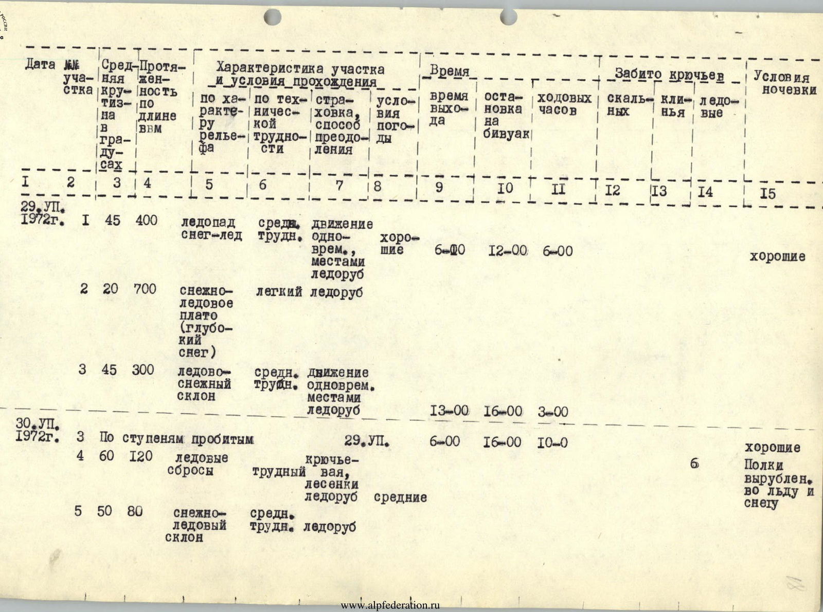
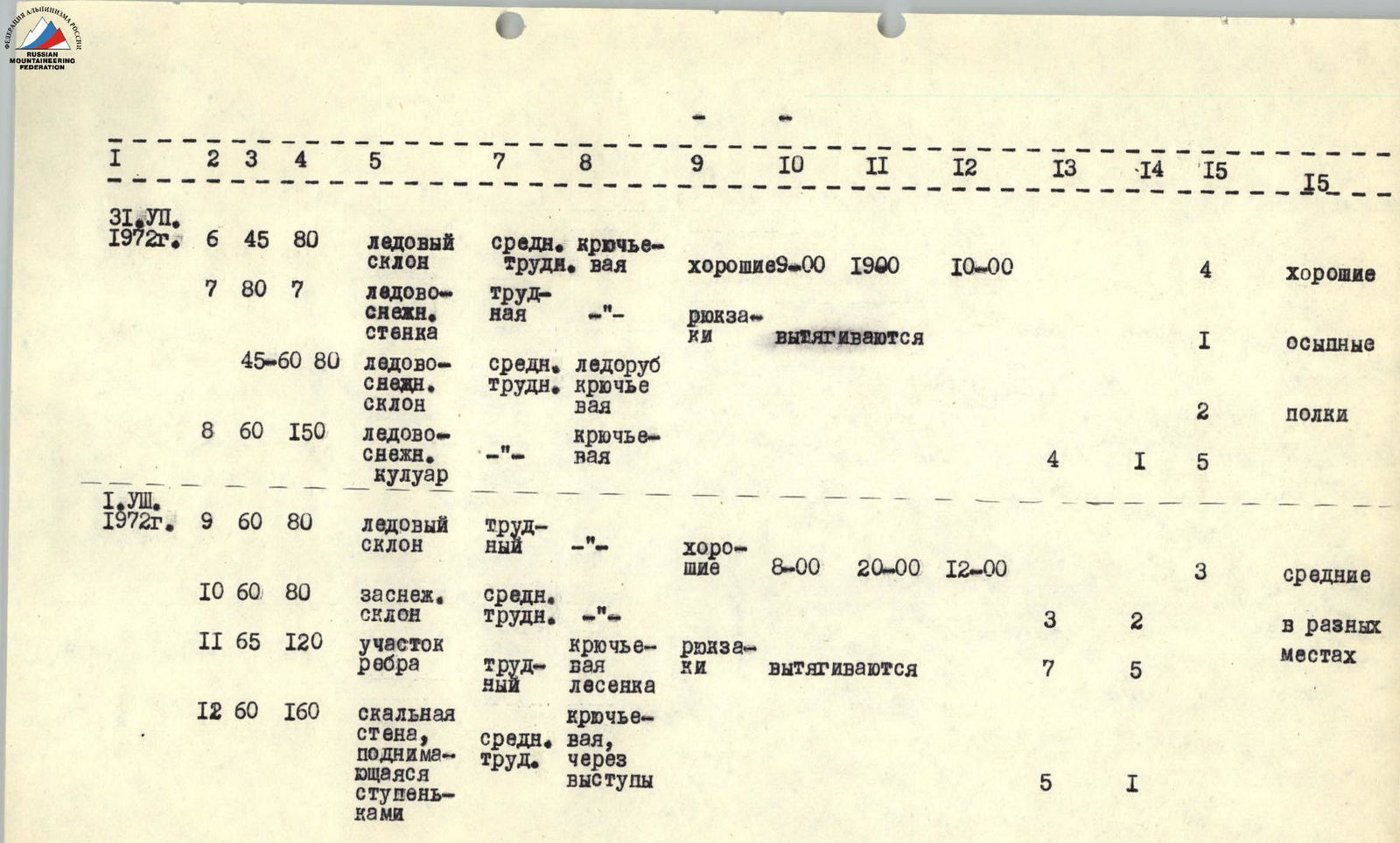
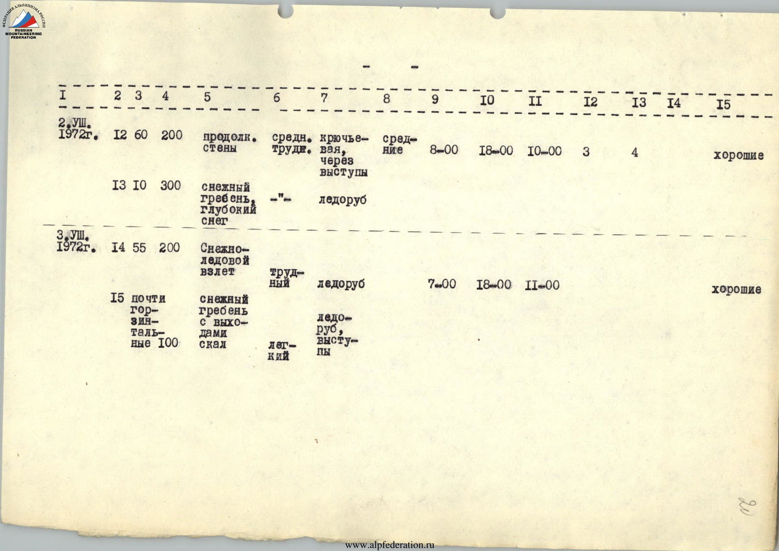
Route passage table
| Date | Section (№) | Average steepness (°) | Length (m) | Characteristics of the section and passage conditions | Departure time | Stop time | Working hours | Pitons used | Camping conditions |
|---|---|---|---|---|---|---|---|---|---|
| July 29 | R1 | 45 | 400 | Icefall, snow-ice, medium difficulty, single rope, occasional ice axe | 6:00 | 12:00 | 6:00 | — | Good |
| R2 | 20 | 700 | Snow-ice plateau (deep snow), easy ice axe | — | — | — | — | — | |
| R3 | 45 | 300 | Ice-snow slope, medium difficulty, single rope, occasional ice axe | 13:00 | 16:00 | 3:00 | — | — | |
| July 30 | R3 (continued) | — | — | Along steps made | 6:00 | 16:00 | 10:00 | — | Good |
| R4 | 60 | 120 | Ice ledges, piton insurance, difficult, ladders, ice axe, average | — | — | — | 6 | Platforms carved out in ice and snow | |
| R5 | 50 | 80 | Snow-ice slope, medium difficulty, ice axe | — | — | — | — | — | |
| July 31 | R6 | 45 | 80 | Ice slope, medium difficulty, piton insurance | 9:00 | 19:00 | 10:00 | 4 | Good |
| R7 | 80 | 7 | Ice-snow wall, difficult, backpacks pulled up, difficult ice axe, piton insurance | — | — | — | 1 | Rocky | |
| R8 | 60 | 150 | Ice-snow couloir, piton insurance | — | — | — | 4 (1/5) | Platforms | |
| August 1 | R9 | 60 | 80 | Ice slope, difficult | 8:00 | 20:00 | 12:00 | 3 | Average |
| R10 | 60 | 80 | Snow-covered slope, medium difficulty | — | — | — | 3 (2) | In different places | |
| R11 | 65 | 120 | Ridge section, difficult, piton insurance, ladder, backpacks pulled up | — | — | — | 7 (5) | — | |
| R12 | 60 | 160 | Rock wall, rising in steps, medium difficulty, piton insurance through ledges | — | — | — | 5 (1) | — | |
| August 2 | R12 (continued) | 60 | 200 | Continuation of the wall, medium difficulty, piton insurance through ledges, average | 8:00 | 18:00 | 10:00 | 3 (4) | Good |
| R13 | 10 | 300 | Snow ridge, deep snow, ice axe | — | — | — | — | — | |
| August 3 | R14 | 55 | 200 | Snow-ice ascent, difficult, ice axe | 7:00 | 18:00 | 11:00 | — | Good |
| R15 | — | 100 | Almost horizontal snow ridge with rock outcrops, ice axe, ledges, easy | — | — | — | — | — |