Report
On the ascent of the North Face of Pik OGPU (First Ascent) 5B
Kiev — 1966
Introduction
The object of the ascent, Pik OGPU, is located in the upper reaches of the Biivachny Glacier in the central Pamirs. This area is frequently visited by mountaineering expeditions and is quite well studied both geographically and sportingly. However, until this season, no attempts had been made to ascend Pik OGPU.
Our team became interested in Pik OGPU as an object of ascent back in 1964. Then, after a successful ascent of Pik Engels, our team leader V. M. Abalakov first told us about the north face of Pik OGPU, and also provided initial information about the face itself, the rocks, and the nature of ascents in this area. Over the past period, we managed to gather extensive material that gave a fairly complete picture of organizing an expedition to the upper reaches of the Biivachny Glacier, as well as the peaks, the nature of ascents, relief conditions, weather, etc. As a result of this preparatory work, the Central Council of the Spartak Sports Society announced Pik OGPU for the USSR championship in the 1966 season.
| № | Surname, First Name, and Patronymic | Sports Rank | Year of Birth | Party Membership | Sports Experience | Profession | Place of Residence |
|---|---|---|---|---|---|---|---|
| 1. | KUSTOVSKY Anatoly Alekseevich (team leader) | Master of Sports | 1925 | Non-partisan | Since 1949 | Engineer | Kiev, Druzhby Narodov St., 18a, apt. 14 |
| 2. | CHEREVKO Vladimir Leonidovich (deputy team leader) | Candidate for Master of Sports | 1934 | CPSU member | Since 1953 | Engineer | Kiev, Elektro-technichesky per., 10, apt. 50 |
| 3. | KARLOV Gennady Stepanovich | Master of Sports | 1935 | Non-partisan | Since 1958 | Engineer | Krasnoyarsk, Svobodny Prospect 65, apt. 14 |
| 4. | YAKOVENKO Yuri Filippovich | Candidate for Master of Sports | 1935 | CPSU member | Since 1954 | Lecturer | Kiev, Yakira St., 17-a, apt. 17 |
| 5. | SEMOCHKIN Georgy Andreevich | Master of Sports | 1933 | CPSU member | Since 1953 | Builder | Kiev, Molodezhnaya St., 33 |
| 6. | SHALAEV Gennady Ivanovich | Master of Sports | 1933 | CPSU member | Since 1953 | Engineer | Lvov, Nalivaika St., 9, apt. 26 |
| 7. | NAUMENKO Igor Mikhailovich | Master of Sports | 1934 | Non-partisan | Since 1953 | Doctor | Kiev, Belorusskaya St., 114b, apt. 2 |
Organizational Plan of the Ascent
The organizational plan of the ascent included a whole range of activities.
- Gathering all participants in Osh and starting the expedition's work — July 5.
- Organizing and relocating the expedition, setting up a base camp on the Biivachny Glacier — July 12.
- Acclimatization and reconnaissance trips, training ascents, organization of preventive and rescue measures, ascent, evacuation, and end of the expedition's work — August 20.
Natural disasters and the resulting significant delay of the helicopter introduced substantial corrections to our plan and caused some unnecessary tension. The organization of the base camp was completed on July 22. One of the two acclimatization and reconnaissance trips was combined with the ascent attempt.
A training ascent was made by Yu. YAKOVENKO and G. SEMOCHKIN, who had not been to the mountains in the previous season. The other participants, due to their excellent health and fitness, limited themselves to acclimatization trips up to an altitude of about 5000 m.
The base camp was set up at an altitude of about 3600 m on the right side (orographic) of the Biivachny Glacier, within a day's journey from Pik OGPU. It should be noted that a significant drawback of helicopter transportation is its dependence on suitable landing sites. In this regard, the old caravan method has a significant advantage.
The reconnaissance of the ascent object began on July 22 with an overflight of the peak by helicopter. The deputy team leader V. CHEREVKO and the expedition leader, Honored Master of Sports of the USSR V. A. KIZEL, examined the north face of Pik OGPU and familiarized themselves with the state of the Biivachny Glacier.
The next day, the group headed to the ascent area. A large quantity of supplies and equipment was transported, and an approximate ascent route was planned.
During the second trip, the Pik OGPU area was thoroughly studied. A descent route was planned down to the ridge between Pik OGPU and Pik Borovshi Vyetnam. The rockfall regime on the face and the nature of the rocks were studied for two days. The rocks, as expected, turned out to be soft, something between sandstone and marble. Part of the route passed through granite outcrops. The ascent route was finally planned, and the necessary equipment was determined.
On the evening of July 30, the group headed under the route. Preventive and rescue measures were ensured by the expedition's forces. The ascent calendar was planned so that during our ascent, either a group led by V. KAVUNENKO was in the base camp or on preparatory work, and vice versa — during the ascent of KAVUNENKO's group on Pik Kommunizma, our group was in the base camp.
During the assault, the group was under constant observation by qualified first-class climbers: V. ZHADAN and I. BATMANOVA. The observers had a 30x telescope and maintained radio contact with us using a "Kievlanka" radio station. The observers were in touch with the base camp and KAVUNENKO's group, if it was on its way. The base camp had regular communication with Osh. The group included a doctor, I. NAUMENKO, a candidate of medical sciences.
Tactical Plan of the Ascent
The tactical plan of the ascent, drawn up before leaving for the mountains and adjusted based on observations and reconnaissance, was as follows.
- Taking into account the experience of ascending Pik Engels, the ascent group should consist of no less than 8 people. Unlike Caucasian routes, where a group of 8 people is somewhat cumbersome, in high-altitude technical ascents, a group of 8 people increases safety and is more flexible in distributing loads.
- The ascent should last 8–9 days.
- The reconnaissance descent route will take about one day, so no supplies will be cached at the summit.
- The nature of the route assumes mostly individual overnight stays and food, which must be taken into account when selecting equipment and organizing food.
- Due to the sufficient snow cover on the face, no special measures will be taken to ensure water supply on the route.
Equipment and Food
Along with the usual equipment, we used some types of equipment successfully employed by teams participating in the championship.
Hooks
The main type were conventional hooks for vertical and horizontal cracks made of titanium. For working with ordinary hooks, weighted hammers (weighing 1100 g) were used. For working with drill hooks and hooks, lightweight hammers (weighing 300 g) were used.
The route made extensive use of:
- Titanium wedges
- Wooden wedges
In addition, the following were used:
- Titanium ice hooks
- Drill hooks made of Amg6 alloy with steel cores and titanium eyes
The drill hooks were manufactured at the Institute of Superhard Alloys of the Academy of Sciences of the Ukrainian SSR. Platforms made of Amg6 aluminum alloy weighed about 300 g.
- Blocks for pulling up backpacks with automatic braking, weighing 125 g.
- Clamps (Abalakov-type) for climbing ropes and pulling up backpacks.
All participants wore "Vibram" boots, either with rubber crampons or with insulation made of foam rubber covered with canvas. Each participant wore a down suit and had a down sleeping bag. The necessary set of woolen clothing (sweater, leggings, etc.) complemented the participants' equipment.
Food organization in the expedition conditions was based on the principle: one person — one day — one package (weighing 600 g). Based on the tactical plan, food was taken for 8 days and 2 reserve days. Thanks to this rational organization, we were able to ensure a normal diet for all participants throughout the ascent.
This principle can be recommended for technical and high-altitude technical ascents.
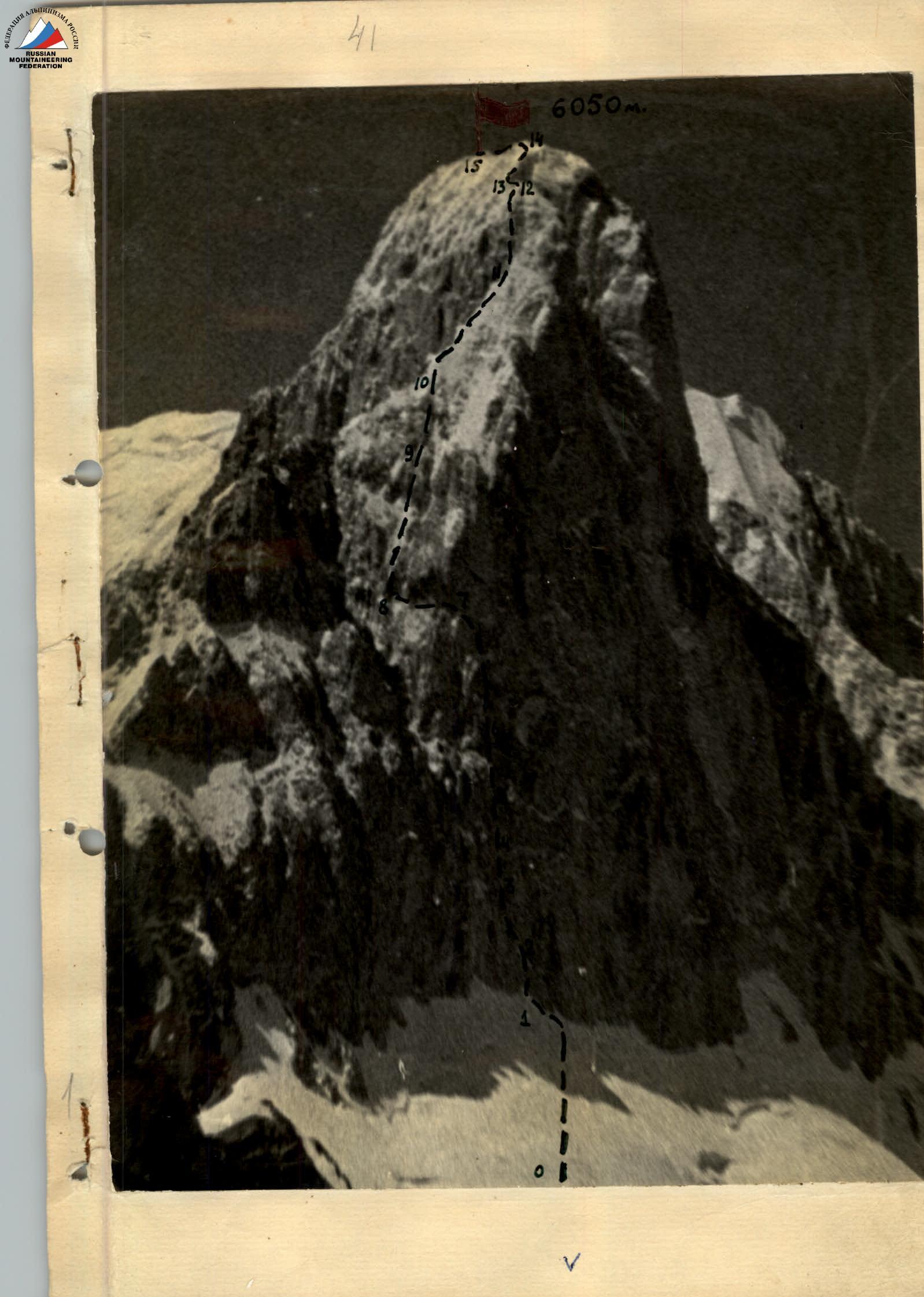
Description of the Ascent
The route begins directly from the Biivachny Glacier with a snow-ice slope with a small rocky island in its lower part. The height of the beginning of the route is about 4200 m. The average steepness of the slope is 50–60°, reaching 70° in the upper part. In the upper part, the slope is intersected by a bergschrund, which is relatively easy to overcome. In general, passing this section does not cause particular difficulties. We reach the route in the evening and, after two hours, the entire group gathers on the rocky island.
July 31. At 8:00, two pairs start and, on crampons with piton protection, begin the ascent. Crampons generally hold well. In some places on exposed ice, we cut steps. Over 9 hours, two pairs have traversed the entire path under the rocks and, having hung ropes in the upper part and across the bergschrund, descend to convenient overnight stays.
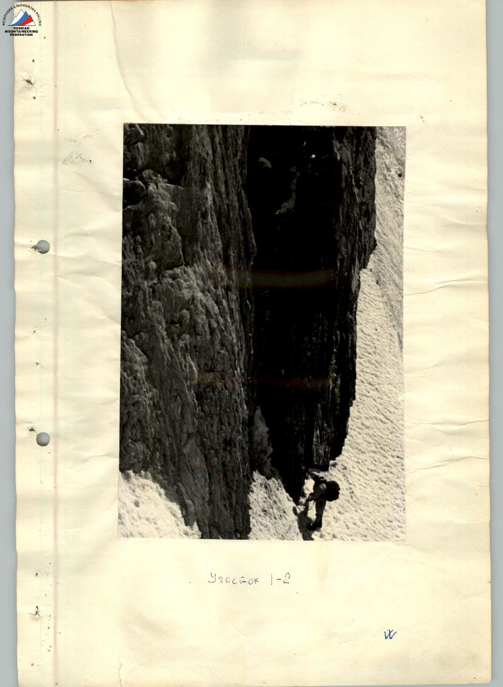
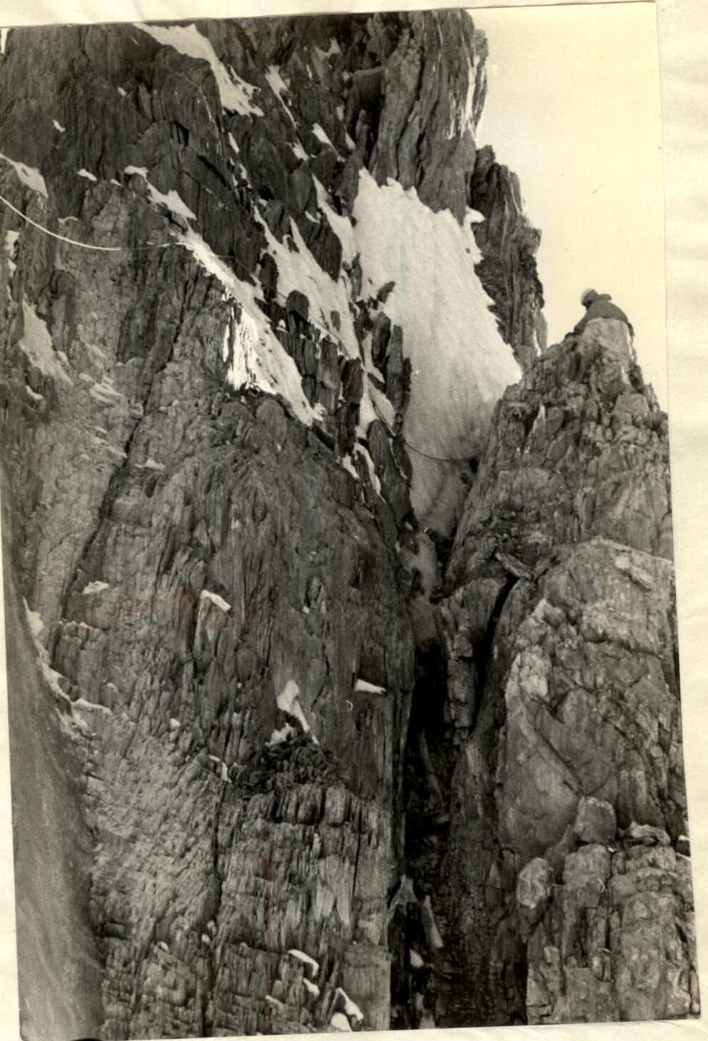
August 1. Along the processed slope, the first pair reaches the rocks by 11:00, hangs their backpacks, and starts ascending the wall. The wall is sheer and almost perfectly smooth, but in its middle part, there is a fissure that can be climbed by free climbing. Climbing is very difficult, we progress slowly; in several places, the first climber hangs and leaves ladders. The fissure leads to an inclined ledge. We organize a two-stage retrieval of backpacks and start preparing for the night. Lying along a stretched rope, we spend the night sitting apart on small ledges.
August 2. Above the ledge, the fissure turns into an ice-filled chimney, blocked by a large ice plug. The width of the chimney and the ice formation do not allow the use of chimney technique, and we have to go along the left (in the direction of travel) wall of the chimney. The entire arsenal of rock climbing techniques is used — drill hooks, ladders, and platforms. This section, about 120 m long, required 11 hours of intense work and was perhaps one of the most challenging sections on the route. Backpacks are pulled up in two stages with an intermediate re-attachment organized on three suspended platforms. Generally, organizing the retrieval of backpacks, despite the use of special blocks and catches, continues to be a "bottleneck" and takes a lot of time and effort. We spend the night again sitting apart on ledges and in hammocks.
August 3. The next section is similar in character to the previous one, but there is no ice formation. At first, we climb using holds, then the chimney widens, and for about 10 m, we have to go on platforms along the right side of the chimney. The chimney is stone-dangerous; one rope was hit by a stone. The chimney leads to the base of an 80-meter wall, which we climb by free climbing. In the middle part of the wall, we had to organize intermediate protection on a platform. After another retrieval of backpacks, we start passing the next section. This is again a 60-meter wall with a very difficult overhanging inner corner at the exit. Here, three ladders and a platform were hung. By 8:00, we finally reach a small balcony where we spend the night sitting in two groups.
All three sections passed during the day are located strictly one under the other, and to reduce stone danger, we had to pass these sections in stages, as a whole group.
August 4. From the overnight stay, a grandiose 700-meter wall with overhangs and cornices stretches upwards to the right, leading almost to the pre-summit ridge. We gaze longingly at the wall, perfectly aware that with the current state of rock climbing techniques, at such an altitude, going there is pure madness. We continue moving in the direction of the left edge of the wall. The path goes along an inner corner with a steepness of about 70°.
An attempt by the second climber to pass this section with a backpack was unsuccessful, and we have to organize another retrieval of backpacks. By 12:00, we approach a 200–250-meter sheer section leading to the edge. From the left, a simpler path is visible, but to reach it, we need to cross a very peculiar vertical ice column made of ice formation. The column resembles a frozen waterfall about 15 m in diameter. We decide that this is still a more straightforward option.
In our practice, we have not encountered passing such columns, and we had to find a way to pass it and organize a crossing for backpacks on the spot. To the left of the ice column, the path goes along a short 10-meter rock wall. The wall gradually turns into a rib with a steepness of up to 70°. We spend the night on this rib, again stretched along a rope.
August 5. We start earlier than on previous days. The rocks are covered in frost, but today the sun should appear earlier, as we have already passed almost half of the wall. The rocky rib leads to an ice groove that gives rise to the ice column. We move along the groove, cutting steps and driving hooks into the left rock wall of the groove. By 18:00, the entire group finally reaches the edge. We see that the path along the edge is relatively simpler; we can go with backpacks. Further on, we even encounter platforms where we can set up a tent. But now, we have to adapt to the conditions again, and we spend the night "scattered" once more.
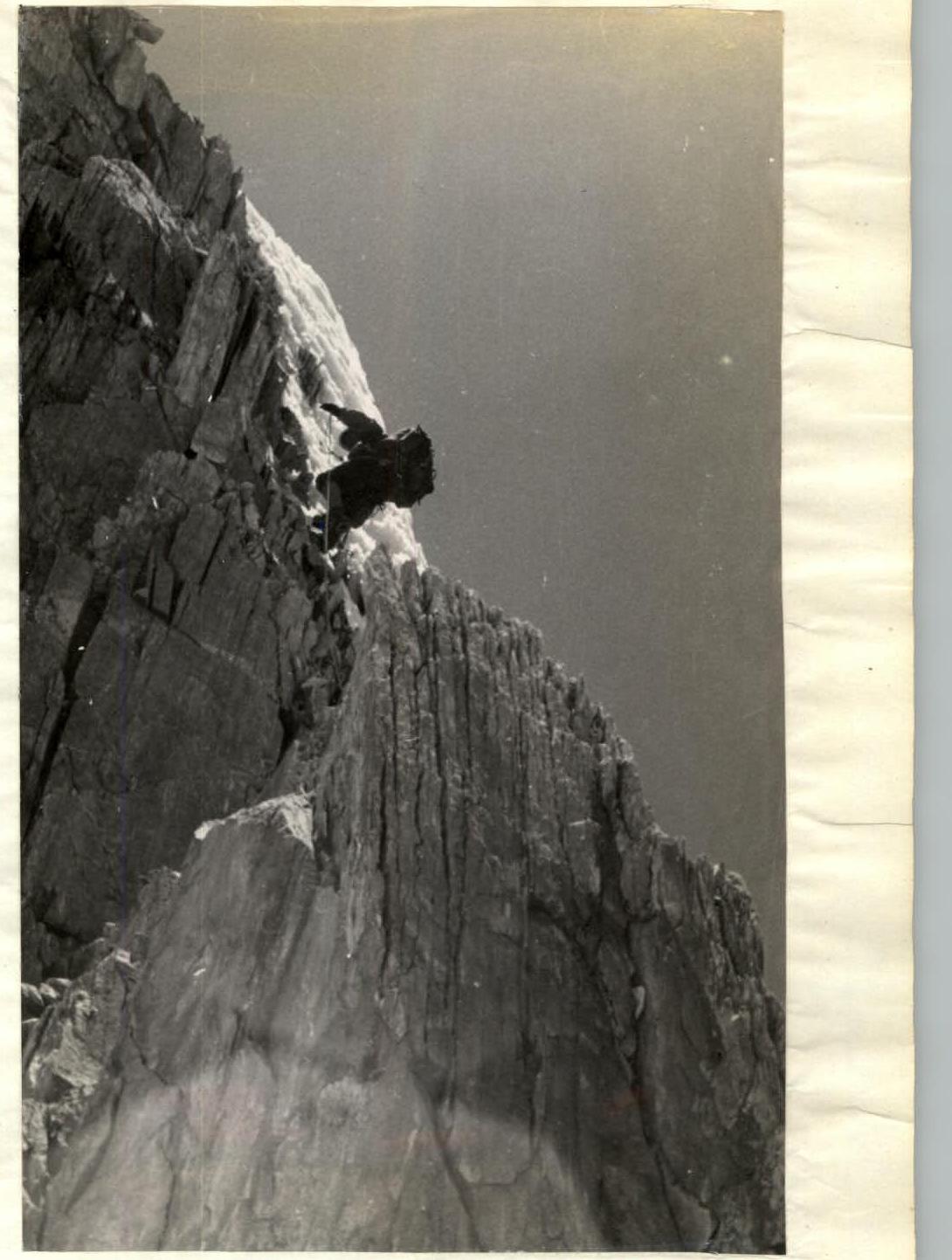
August 6. The path along the edge is a series of steep (up to 70°) ascents of a ridge character with cornices and individual rock outcrops. Despite the high altitude, we progress relatively quickly. Gradually, the steepness of the edge increases, and by evening, we reach a 200-meter ascent leading to the shoulder of the wall. Here, we manage to cut down a cornice and set up tents. For the first time, we spend the night together.
August 7. Our worst fears regarding this section, expressed during observations, unfortunately, were confirmed. The section is a series of smooth rocks like "ram's foreheads," covered in snow and ice. The average steepness is about 80°; some areas are sheer. We have to clear a lot of ice and snow to get to the rocks. There are few holds and even fewer cracks. The rock is very soft, and we cannot use drill hooks. We are saved only by ice hooks, which are driven into the rocks right into the "living flesh." We hang all our stock of ladders, as well as ladders from platforms. Finally, after about 5 hours, we reach the shoulder. From here, the pre-summit ascent is clearly visible, to which a nearly horizontal ridge with two small "gendarmeries" leads. The ridge itself, except for the "gendarmeries," does not cause particular difficulties. The "gendarmeries" cannot be bypassed, and we have to take them head-on and pull up the backpacks. We spend the night in three groups on the ridge.
August 8.
We are awakened by the bright Pamir sun, illuminating everything around, and only to the north does the dark abyss of the wall yawn. From the end of the horizontal ridge, the final 200-meter ascent begins, leading to the pre-summit ridge. The ascent is a rib of a ridge type with alternating sections of steepness 75–85° with chaotic accumulations of cornices and snowdrifts, and with individual rock outcrops. The snow is somewhat deceptive. A huge cornice turns out to be completely empty, and we keep sinking waist-deep into the snow, literally digging a trench in it. In two places, we had to cut through cornices.
Finally, after several hours of this snowy "swimming," we reach the pre-summit ridge. From here, the summit is visible, to which a nearly horizontal snow ridge about 300 m long leads. A few more hours of walking, and finally, at 2:00, we are on the summit. The weather starts to deteriorate, and we, without lingering on the summit, write a note, build a cairn, and begin our descent.
We descend in the direction of the ridge between Pik OGPU and Pik Borovshi Vyetnam. The weather deteriorates completely; a solid fog sets in. At first, we sit and wait for "windows"; then, we decide to set up for the night. We cut out two excellent platforms and set up tents.
August 9. In the morning, it clears up a bit, and the descent route is clearly visible. The descent is of a ridge type, rock-ice, approximately 4–5 category of difficulty. We descend using a sport climbing method, in two places — through a carabiner. By 2:00, we descend to the ridge. From here, a snow-ice slope about 60° steep, ending in an icefall, leads to the Biivachny Glacier. On this day, we do not manage to reach our observers and spend the night right on the Biivachny Glacier.
August 10. We descend to the observers, dismantle their camp, and, along the glacier and then along the trail, return to the base camp.
Table
Main characteristics of the ascent route on the north face of Pik OGPU
The height difference of the route is 1855 m, including 1205 m of complex sections.
The steepness of the route, including complex sections, is 85–100°.

| Date | Section | Steepness in degrees | Height along the route | Characteristic of the section | Technical difficulty | Weather conditions | Insurance type | Departure time | Stop time for bivouac | Hiking hours | Rock climbing | Ice climbing | Drill hooks | Wedges | Overnight stay conditions | Daily ration weight |
|---|---|---|---|---|---|---|---|---|---|---|---|---|---|---|---|---|
| 31.07 | 0–1 | 60 | 320 | Snow-ice slope, bergschrund | Medium difficulty | clear | piton insurance | 17:00 | 9 | 3 | 18 | – | – | Platform on the island | 800 | |
| Total for the day | 320 | 11 | 3 | 18 | – | – | 800 | |||||||||
| 01.08 | 0–2 | 90 | 80 | Smooth sheer wall with few holds | Free climbing, ladders. Backpacks pulled up twice | clear | " | 11:00 | 18:00 | 7 | 19 | – | – | – | ||
| Total for the day | 80 | 10 | 19 | – | – | – | 600 | |||||||||
| 02.08 | 2–3 | 90–100 | 120 | Chimney, smooth rocks covered in ice | Extremely complex climbing. In some places with platforms | clear | piton insurance | 8:00 | 19:00 | 11 | 38 | – | 12 | – | Sitting apart and in hammocks | 600 |
| Total for the day | 120 | 11 | 38 | – | 12 | – | ||||||||||
| 03.08 | 3–4 | 85 | 60 | Wide chimney with exit to a vertical wall without holds. Stone-dangerous | Complex climbing. All go without backpacks. Ladders and platforms used | clear | " | 8:00 | 12:00 | 4 | 18 | – | 5 | 3 | ||
| 4–5 | 80–85 | 60 | Wall made of soft rocks with live stones | Complex free climbing. Insurance in the middle from a suspended platform | " | " | 12:00 | 14 | – | 3 | 2 | |||||
| 5–6 | 80 | 80 | Wall consisting of stepped vertical sections. In the middle — an overhang about 5 m | Climbing with ladders. Backpacks pulled up | " | " | 14:00 | 19:00 | 4 | 14 | – | 2 | 3 | Sitting on ledges in two groups | ||
| Total for the day | 200 | 11 | 43 | – | 10 | 8 | 600 | |||||||||
| 04.08 | 6–7 | 70 | 140 | Inner corner, "live" stones | Free climbing. Backpacks pulled up | " | " | 8:00 | 12:00 | 4 | 19 | – | – | 6 | ||
| 7–8 | 80 | 65 | Section of complex ice-covered rocks with traverse of an ice "column" | Free climbing, ladders. Backpacks pulled up | clear | piton insurance | 12:00 | 18:00 | 6 | 12 | 9 | 1 | 2 | Sitting apart, part of the group on suspended platforms | ||
| Total for the day | 205 | 10 | 31 | 9 | 1 | 8 | 600 | |||||||||
| 05.08 | 8–9 | 70–80 | 200 | Steep rocky rib leading to an ice groove. Up the groove along its left rock wall | Complex climbing — first without a backpack, others (except 20 m) with backpacks | " | " | 7:00 | 18:00 | 11 | 32 | 6 | – | – | Sitting in pairs | |
| Total for the day | 200 | 11 | 32 | 6 | – | – | 600 | |||||||||
| 06.08 | 9–10 | 70 | 100 | Rocks covered in snow and ice | First without a backpack, others with backpacks | " | " | 8:00 | 12:00 | 4 | 19 | – | – | 2 | ||
| 10–11 | 70 | 180 | Snow-ice edge with cornices and rock outcrops | Medium complexity. First with a light backpack | " | piton and ice axe insurance | 12:00 | 18:00 | 6 | 11 | 2 | – | – | On platforms cut out of ice in tents | ||
| Total for the day | 280 | 10 | 30 | 2 | – | 2 | 600 | |||||||||
| 07.08 | 11–12 | 80 | 200 | Rocky ascent, rocks like "ram's foreheads," snow, ice, few cracks | Extremely complex and dangerous. Soft rocks. Ladders used | " | piton insurance | 7:00 | 17:00 | 10 | 27 | 14 | – | 2 | Sitting in three groups on the ridge | 600 |
| Total for the day | 200 | 10 | 27 | 14 | – | 2 | ||||||||||
| 08.08 | 12–13 | 5 | 10 | Horizontal ridge, soft, heavily destroyed rocks | Alternating movement with backpacks | clear | through ledges and pitons | 8:00 | 10:00 | 2 | 2 | – | – | – | ||
| 13–14 | 75–85 | 200 | Pre-summit ascent with large cornices, snowdrifts, and rock outcrops | Powdery snow, cornices, and snowdrifts. First without a backpack | windy, cloudy | combined | 10:00 | 14:00 | 4 | 10 | 8 | – | 1 | |||
| 14–15 | 5 | 40 | Snow ridge leading to the summit about 300 m long | Alternating movement in rope teams | windy, cloudy | through ice axe | 14:00 | 16:00 | 2 | 12 | 1 | – | – | |||
| Total for the day | 250 | 8 | 24 | 9 | – | 1 | 600 | |||||||||
| 09.08 | 15–16 | 70 | 400 | Descent to the ridge to Pik Borovshi Vyetnam | Rock and snow-ice route 4–5 category of difficulty | windy, cloudy | combined | 8:00 | 14:00 | 6 | 19 | – | – | 2 | ||
| 16–17 | 60 | 1250 | Descent to the Biivachny Glacier along a snow-ice slope | Medium difficulty | through ice axe | 14:00 | 19:00 | 5 | – | – | 2 | – | ||||
| Total for the ascent | 1650 | 11 | 19 | 2 | – | 2 | 600 | |||||||||
| Total for the climb: | 1855 | 90 | 247 | 58 | 22 | 23 |
Evaluation of the Route and Participants' Actions
During the preparation for the ascent of Pik OGPU, our team carried out an extensive program of physical and technical training.
The team has regularly participated in the USSR championship in the class of technical and high-altitude technical ascents since 1961. Participating in the USSR championship, the team has repeatedly taken prize places, and in the 1964 season, it was awarded the title of champions for the ascent of Pik Engels.
Thorough preparation and clear, purposeful actions of the team members ensured the successful passage of the complex high-altitude wall route.
The route taken by the team on the north face of Pik OGPU is a logical, beautiful, and interesting path to the summit in sporting terms. Given the team's extensive experience in complex wall ascents, it is considered that this route is undoubtedly a route of 6B complexity category.
On behalf of the team,
Team leader KUSTOVSKY A.
 32.6
32.6
 Section 2.10–11
 Section 2.10–11