PASSPORT
- High-altitude class
- Central Pamir
- Peak Korzhenevskaya, via the Southwest Ridge
- Proposed - 5B category of difficulty, first ascent
- Elevation gain: 2800 m, route length 5000 m. Length of sections with 5th category of difficulty - 3000 m. Average steepness of the main part of the route 50° (5100–6100 m).
- Pitons used: rock 23/0 chocks 12/2 ice 34/3
- Team's travel hours: 29 hours and 4 days
- Overnights: 1st on a scree shelf, 2nd and 3rd on a platform, carved out on the snow-ice ridge for 8 people.
- Team leader: Viktor Viktorovich Markelov — Master of Sports
Team members:
- Vladimir Nikolaevich Puchkov — Master of Sports of International Class
- Valery Vasilievich Khomutov — Master of Sports of International Class
- Yuri Borodkin — Master of Sports
- Sergey Georgievich Bogomolov — Master of Sports
- Viktor Vasilievich Sklyarov — Master of Sports
- Pavel Antonovich Chochia — Master of Sports
- Gennady Georgievich Bogomolov — Candidate for Master of Sports
- Coach: Nikolai Dmitrievich Cherny
- Start of the route: July 17, 1984. Summit — July 19, 1984, return — July 20, 1984.
- Organizing body — MAL — "Pamir-84"
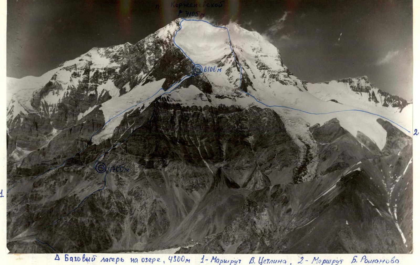
General photo of the summit. Taken on July 31, 1984, from Yu. Borodkin's route on Peak
Kommunizma. Height about 6000 m. 12:00. Lens T-22, F = 75 mm. Distance to the object ≈ 10 km. Shooting point No. 1.

Photo 3. Profile of the Southwest Ridge. Taken from the West from a helicopter (height about 4500 m). Distance to the object approximately 2 km. August 3, 1984, 11:00. Lens I-26m. F = 52 mm. Shooting point No. 2.
Tactical Actions of the Team
The team's tactical actions were developed during preparation for the ascent and were not deviated from during the climb. The rope teams were formed and worked on sections in a specific order, with the lead climbers changing as follows:
Markelov V., Chochia P. — sections 3–4, 4–5; Borodkin Yu., Bogomolov S. — sections 1–2, 5–6; Puchkov V., Khomutov V. — section 6–7; Sklyarov V., Bogomolov G. — section 2–3. There was no preliminary processing of the sections, but fixed ropes were set up on sections 1–2 — 20 m and 3–4 — 80 m.
The regime of movement and rest followed established tradition: breakfast and dinner at 7:00 and 19:00, respectively, and lunch during the hottest part of the day — 13:00.
Overnight stays were organized for two tents, fully set up to ensure a good night's rest.
Safety measures were fully in line with the state of the snow, ice, difficulty of the rock section (5100–6100 m), and weather conditions; there were no falls or injuries.
The solution to overcoming the rock tower on section 3–4 was ensured by:
- appropriate selection of rock climbing equipment;
- excellent technical and physical preparedness of the participants.
To pass the ice part of the route on sections 1–2 and 5–6, the following were used:
- improved design ice screws;
- a device for screwing them in.
The team's actions in bad weather on section 6–7 (snow, fog) fully complied with necessary safety measures:
- movement of rope teams within visibility;
- marking of crevasses;
- organization of alternate belays where necessary.
Communication with observers (base camp) was strictly according to schedule. There were no communication disruptions.
These issues are reflected in photos No. 6–11.
|  |
|  |
|  |
|  |
|  |
|  |
|  |
|  |
|  |
|  |
|
Description of Movement by Sections
Section 0–1
From the base camp, transition to the right moraine of the Moskvina Glacier and then via scree slopes and ridges to the approach under the "reddish" triangular rock, marking the start of the Southwest Ridge. Ridge sections with rocks are climbed using free climbing. On the scree slope under the "reddish" rock, a platform is laid out for an overnight stay.
Section 1–2
From the overnight stay platform, transition left across a stream (rockfall, mudflow hazard) into a couloir. Ascent up the couloir (200 m) via its right side and at the point of lowering, ascend to the ridge. Cross the ridge towards the Southwest Ridge and a large snow-ice couloir. Fixed ropes 20 m. Descend from the ridge into the narrowing part of the snow-ice couloir (crampons), cross it, and ascend via its right side to the Southwest Ridge. On the ascent up the snow-ice field (45–50°) of the couloir (300 m), piton belays are necessary, crampons. Exit onto the Southwest Ridge.
On the ridge:
- Overnight stay platform
- Control cairn
Height: 5100 m. From the overnight stay — 3 hours.
Section 2–3
From the control cairn, move exactly along the ridge towards the tower. There are no options to bypass the tower. Movement in rope teams with alternate belays through outcrops and using rock pitons and chock stones. The ridge is composed of granite. Rocks are large-block and monolithic. Very pleasant for climbing.
Approach under the tower exactly along the ridge.
Meeting point for the group under the tower.
Piton belay.
Section 3–4
Overcoming the tower starts from the right via an internal corner turning into a chimney with a plug. Piton belay using chock stones as artificial footholds. Backpacks are pulled up. For movement, a fixed rope is used. Ascent to the top of the tower. Meeting point for the group.
Section 4–5
From the top of the tower, move along the ridge towards a snow cornice. On the ridge — a "gendarme" 40 m high. Rock is friable, unreliable; holds are formed using an ice axe, hammer. Belay point at the top of the "gendarme". Climbing is extremely attentive and cautious.
From the top of the "gendarme", move along the ridge under a snow cornice 5–6 m high. The cornice is traversed on artificial footholds using ice screws, ice axe, and axe. Meeting point for the group.
Section 5–6
From the top of the cornice, along the right edge of the snow field, move towards the 6100 m saddle. At the point where the field transitions into the rock ridge, move left of the ridge via an ice slope with piton belays (400 m). Exit onto the 6100 m saddle. Overnight stay platform.
Section 6–7, descent
From the saddle, move to the summit along the ridge via Tsetlin's route. Return from the summit to the saddle via the ascent route and then via Tsetlin's route to the "Dusty Meadow" and to the base camp.
Technical Characteristics of the Route (by Sections)
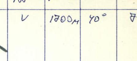
| Category of difficulty | Length, m | Steepness, ° | Section | Rock pitons (units) | Chock stones (units) | Ice screws (units) |
|---|---|---|---|---|---|---|
| V | 1700 | 40 | 7 | 25 | 13 | |
| V | 560 | 45 | 6 | 2 | 2 | 5/3 |
| V | 115 | 60 | 5 | 15 | 8/2 | 10–11 |
| V–VI | 110 | 70 | 4 | 4 | 2 | 90 |
| V | 520 | 50 | 3 | 80 | 70 | |
| III–IV | 600 | 40 | 2 | 2 | 4 | |
| I–III | 1300 | 20–30 | 1 | 2 |
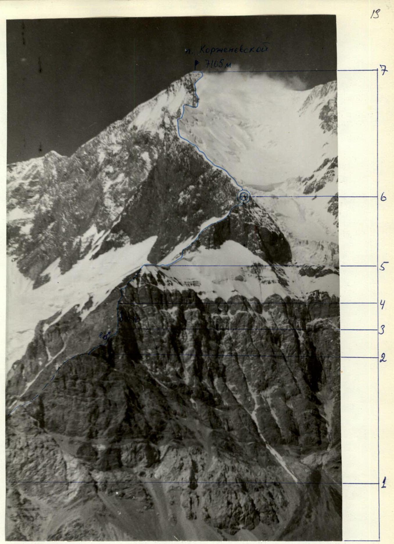
Technical photo of the route. Taken on July 31, 1984, from Yu. Borodkin's route on Peak Kommunizma. Height about 6000 m. Lens T-22, F = 75 mm. Distance to the object ≈ 10 km. Shooting point No. 1.