Ascent Passport
- Ascent category — high-altitude.
- Region — Pamir, Academy of Sciences Range.
- Peak Communism, 7495 m, via the left buttress of the SW wall. V. Onishchenko, 1970.
- Proposed — 6B cat. diff., second ascent.
- Elevation gain: 2595 m, length — 2870 m (to reaching the summit ridge). Average steepness of the main part of the route — 64° (5400–7200 m), including 6B cat. diff. 90° (6020–6140 m), 80° (6370–6460 m), 80° (200 m long on other sections), total 6B cat. diff. — 420 m.
- Pitons hammered:
| Rock | Bolts | Nuts | Ice screws |
|---|---|---|---|
| 229 | 0 | 114 | 33 |
| 28 | 0 | 27 | 3 |
-
Team's total climbing hours — 100 and 10 days (including a rest day).
-
Overnight stops: 2 sitting and 7 lying on prepared ledges.
-
Team leader: Viktor Vladimirovich Zhak, Master of Sports
Participants:
- Nikolai Rufovich Ivanov, Master of Sports
- Valery Anatolyevich Sokolov, Candidate for Master of Sports
- Sergey Alekseyevich Belykh, Candidate for Master of Sports
- Sergey Viktorovich Kotin, Candidate for Master of Sports
- Boris Mikhailovich Mednik, Candidate for Master of Sports
- Sergey Viktorovich Kuznetsov, Candidate for Master of Sports
-
Team coach — Yuri Georgievich Dzhibraev.
-
Date of departure on the route — August 12, 1988.
Summit reached — August 21, 1988, return — August 22, 1988.
-
Organization — Physical Culture and Sports Committee of the Leningrad City Council Executive Committee.

Photo 1. General photo of the summit. Taken on August 6, 1988, at 12:00. Focal length — 5 cm from a distance of 5.5 km, shooting point on scheme 2. Shooting height 6389 m (from Patriot peak). The route, overnight stops, and elevations are shown.
The team's movement on the route was carried out in a mode that ensured the fulfillment of the stated intense tactical plan. Work on the wall was conducted almost throughout the daylight hours for 12–14 hours for the first rope and for 10–12 hours for the rest of the team members. This mode of movement, on the one hand, made it possible to prepare overnight stops, and on the other hand, ensured the creation of a "reserve" for the next day's work. In total, the team spent 100 climbing hours to complete the route. The implementation of the tactical ascent plan was seriously complicated by unstable weather during the ascent period, as well as a sharp cold snap that began on August 13. Air temperature measurements taken at 9:00 each day of the ascent gave the following results: 12.08 — –2°C, 13.08 — –5°C, 14.08 — –10°C, 15.08 — –15°C, 16.08 — –9°C, 17.08 — –17°C, 18.08 — –17°C, 19.08 — –15°C, 20.08 — –17°C. In addition, from the evening of August 14 to the middle of the night on August 15, there was a sharp deterioration in the weather with a significant amount of snowfall — this did not allow the team to start moving on August 15, and on August 15 — to change the overnight location. In the second half of the day on August 16, 17, 18, 19, 20, 21, it also snowed. These circumstances forced the team to use 2 reserve days provided for in the tactical plan and significantly slowed down the team's movement on the route. This overall led to the team reaching the summit on the 10th day of the ascent.
Overall, the ascent developed according to the following scheme: 1st day (August 12). Main task — passage of the lower part of the wall with an elevation gain of about 500 m. Sections R0–R5 were covered. The first rope to work was Zhak–Sokolov–Kuznetsov. Work was carried out from 6:00 to 21:00.
2nd day (August 13). Main task — reaching the rocks of the first triangle. Sections R5–R10 were covered. The first rope to work was Ivanov–Belykh. A bivouac was set up at the beginning of section R7 due to the presence of a small ledge under an overhang. Work was carried out from 9:00 to 21:00.
3rd day (August 14). Main task — reaching overnight stops near the base of the second triangle. Sections R10–R18 were covered. The first rope to work was Zhak–Sokolov. Snowfall started at 18:00. Work was carried out from 9:00 to 20:30.
4th day (August 15). Snowfall continued throughout the day and the previous night. No movement was made on this day.

Photo 3. Photopanorama of a section of the Academy of Sciences Range. Taken on August 5, 1988, at 16:00, focal length — 5 cm from a distance of 6 km. Shooting point on scheme 1. Shooting height 6100 m. Routes are marked. (Right photo from the archive of the USSR Alpine Federation).
5th day (August 16). Main task — passage of the steep inner corner on the second triangle and reaching the "sickle". Sections R18–R23 were covered. The rope Belykh–Ivanov worked ahead. It was decided not to change the overnight location. Work was carried out from 9:30 to 20:00. Snow started at 16:00.
6th day (August 17). Main task — reaching the base of the "pencil". Sections R23–R27 were covered. The rope Zhak–Sokolov worked ahead. A bivouac was set up on a steep ice ridge (section R26–R27). Work began at 9:00, ended at 20:30. Snowfall and fog started at 17:00.
7th day (August 18). Main task — passage of the "pencil". Sections R27–R29 were covered. The rope Ivanov–Belykh worked ahead. The terrain was extremely difficult, and snow was falling from 16:00. Very cold. Overnight stop remained at the same location. About 20 m left to ease the route. Worked from 9:30 to 20:00.
8th day (August 19). Main task — reaching the base of the "pie". Sections R29–R37 were covered. The rope Zhak–Sokolov worked ahead. Snowfall continued throughout the night. The route condition was difficult. Work was carried out from 9:00 to 20:30. Snow started at 17:00.
9th day (August 20). Main task — reaching a ledge in the upper third of the "pie". Sections R37–R43 were covered. Ivanov–Belykh worked ahead. About 2.5–3 ropes left to reach the "roof". Information was sent down that they would spend the night almost on the ridge. Work began at 9:00, ended at 20:00. Weather deteriorated from 15:00 — snow, fog.
10th day (August 21). Main task — reaching the summit. Sections R43–R46, summit were covered. The rope Mednik–Kotin worked ahead. Work began at 9:30. Reached the ridge at 12:00. Snow ("graupel") started at 13:00. Reached the summit at 16:00. Descended to the serac zone above the Pravda peak plateau by 22:00.
The safety of the ascent was ensured by stable, uninterrupted radio communication with observers, double-rope belays on exposed sections, and the first climber also using a double rope. The team had two first-aid kits and spare batteries for the radio station. Great attention was paid to the selection of bivouac sites. The main criteria for this were safety and convenience. Almost throughout the entire ascent, the team spent significant time preparing overnight stops — this fully justified itself: out of 9 overnight stops, only 2 were semi-reclining.
There were no falls or injuries during the ascent period.
Route scheme in UIAA symbols

| № | Rock | Nuts | Ice screws | Bolts | Steepness | Length | Category of difficulty | Remarks |
|---|---|---|---|---|---|---|---|---|
| 2 | 3 | 1 | - | - | 45° | 40 | IV | Elevation 4900 m, 12.08.88 |
| 3 | 4 | 3 | - | - | 60° | 40 | V+ | |
| 4 | 1 | 4 | - | - | 70° | 40 | V+ | |
| 5 | 5 | 2 | - | - | 60° | 60 | V- | Elevation 5450 m, 12.08.88 |
| 6 | 9 | - | - | - | 60° | 60 | V+ | Elevation 5550 m |
| 7 | 5 | 1 | - | - | 70° | 40 | V+ | |
| 8 | 8 | - | - | - | - | 60 | V | |
| 9 | 8/2 | 6/4 | - | - | 90° | 50 | VIA1 | 13.08.88 |
| 10 | 4/1 | 4/3 | - | - | 80° | 30 | VIA1 | Elevation 5620 m |
| 11 | 4/2 | 1/1 | 2 | - | 80° | 20 | VIA1 | |
| 12 | 3 | 1 | 1 | - | 60° | 40 | V | |
| 13 | 4 | - | - | - | 80° | 30 | VI | |
| 14 | 9 | 6 | - | - | 50° | 80 | V- | |
| 15 | 1 | 4/2 | - | - | 30° | 20 | II | |
| 16 | 3 | 3 | - | - | 80° | 10 | VIA1 | 14.08–16.08.88 (15.08 — rest) |
| 17 | 4 | 2 | - | - | 60° | 40 | V- | Elevation 5930 m |
| 18 | 1 | 4 | - | - | 70° | 40 | V+ | |
| 19 | 5 | 2 | - | - | 50° | 40 | V+ | |
| 20 | 4 | 1 | - | - | 50° | 40 | V+ | |
| 21 | 9/3 | 8/4 | 1 | - | 90° | 60 | VIA1 | |
| 22 | 12/3 | 8/4 | - | - | 90° | 60 | VIA1 | 16.08.88 (6140 m processed) |
| 23 | 2/2 | 5 | - | - | 60° | 20 | V+ | |
| 24 | - | - | 3 | - | 45° | 80 | IV | |
| 25 | 6 | 1 | - | - | 70° | 40 | V+ | |
| 26 | - | - | 3 | - | 45° | 80 | IV | |
| 27 | - | 3 | - | - | 70° | 40 | V+ | 17.08.88 (6300 m) |
| 28 | 17/2 | 8/8 | - | - | 80° | 80 | VIA1 | 18.08.88 |
| 29 | 6 | 2 | - | - | 90° | 20 | VIA1 | Elevation 6440 m, 18.08.88 (processed) |
| 30 | 3 | - | 1 | - | 70° | 30 | V- | |
| 31 | 9/2 | 4 | 1 | - | 70° | 80 | V+ | |
| 32 | 3/2 | 1 | 2/2 | - | 80° | 20 | VI | |
| 33 | 2 | - | 1 | - | 90° | 20 | V+ | |
| 34 | 3 | 3 | - | - | 70° | 40 | V+ | |
| 35 | - | - | 3 | - | 55° | 40 | V- | |
| 36 | 5/2 | 2 | - | - | 50° | 40 | V+ | |
| 37 | - | - | 3 | - | 45° | 80 | IV | Elevation 6680 m, 19.08.88 |
| 38 | 5/3 | 3/1 | 1/1 | - | 80° | 40 | VIA1 | |
| 39 | 7 | 2 | - | - | 80° | 40 | V | |
| 40 | 2 | 4 | - | - | 70° | 50 | V+ | |
| 41 | - | - | 3 | - | 40° | 50 | IV+ | |
| 42 | 4 | 1 | - | - | 70° | 40 | V+ | |
| 43 | - | - | - | - | 40° | 40 | IV | Elevation 6960 m, 20.08.88 |
| 44 | 6 | - | - | - | 70° | 40 | V+ | |
| 45 | 8 | 2 | - | - | 60° | 80 | V+ | |
| 46 | - | 5 | - | - | 45° | 160 | IV | |
| 47 | - | - | - | - | Climbing time 4 h, cat. diff. 111, elevation 7200 m, summit 7495 m |
Route description by sections
R0–R1 Snow-ice slope leading to the base of the rock "paw".
R1–R2 System of walls and ledges. Rocks are crumbling, starting from the 3-4 rope. Organizing belays is extremely difficult. Exit to the left part of the "paw".
R2–R4 Rock ridge abutting against the wall of the 1st triangle, a gentle wall.
R4–R5 Inclined (left–right) inner corner. Exit to a small ledge under a steep wall. Overnight stop (uncomfortable).
R5–R7 Movement on slabs bypassing the steep wall on the right–left. Overnight stops under an overhanging wall.
R7–R8 Bypass on the left on a slab of the overhanging wall. Live rocks.
R8–R9 Traverse to the right — 60 m on a narrow (no more than 0.3 m) ledge. Belaying is difficult. Climbing with extreme caution — possible rockfall from above. Exit to the base of the inner corner.
R9–R10 Steep inner corner. Extremely difficult climbing. Crumbling rocks.
R10–R12 Steep (almost vertical) slab. Extremely difficult climbing. Upper part of the slab is iced. Belaying is difficult due to the friability of the rock and ice.
R12–R13 Slab easing in steepness, iced.
R13–R14 Steep inner corner. Possible bypasses on the left and right are impossible due to the significant destruction of rocks.
R14–R18 Slab leading to the base of a small ridge abutting against a steep wall with extremely difficult aid climbing. After the wall, on a slab, exit to the right–left on a ledge. Overnight stop.
R18–R21 System of walls iced. Belaying is difficult. Exit to the base of the inner corner on the edge of the 2nd triangle.
R21–R23 Steep inner corner divided by a cornice into 2 sections. Extremely difficult climbing. Almost the entire corner is passed using aid climbing.
R23–R24 Wall leading to the base of the ridge. Ice on the ridge.
R24–R25 Ice ridge — wall — ice ridge abutting against the wall of the "pencil". Overnight stop on the ridge.
R25–R27 System of walls. Few cracks, mostly "blind". Extremely difficult aid climbing.
R27–R30 System of walls. Few cracks, mostly "blind". Extremely difficult aid climbing.
R30–R32 System of walls iced. Aid climbing on some sections.
R32–R35 System — inner corner — wall — inner corner. Movement from left to right. Rocks are iced.
R35–R36 Ice slope leading under the wall.
R36–R37 Wall iced. No cracks. Belaying is difficult.
R37–R38 Ridge. Overnight stop at the base of the ridge.
R38–R39 Practically vertical wall in ice. Extremely difficult aid climbing.
R39–R41 Two inner corners divided by a small ledge. Corners lead to a snow-ice field, where an overnight stop is set up.
R41–R42 Snow-ice field.
R42–R43 Wall leading to the last field of the "pie".
R43–R44 Snow-ice field.
R44–R46 System of walls leading to the "roof". Wide crevices.
R46 Summit — snow-ice field leading to the summit ridge. Movement from left to right.
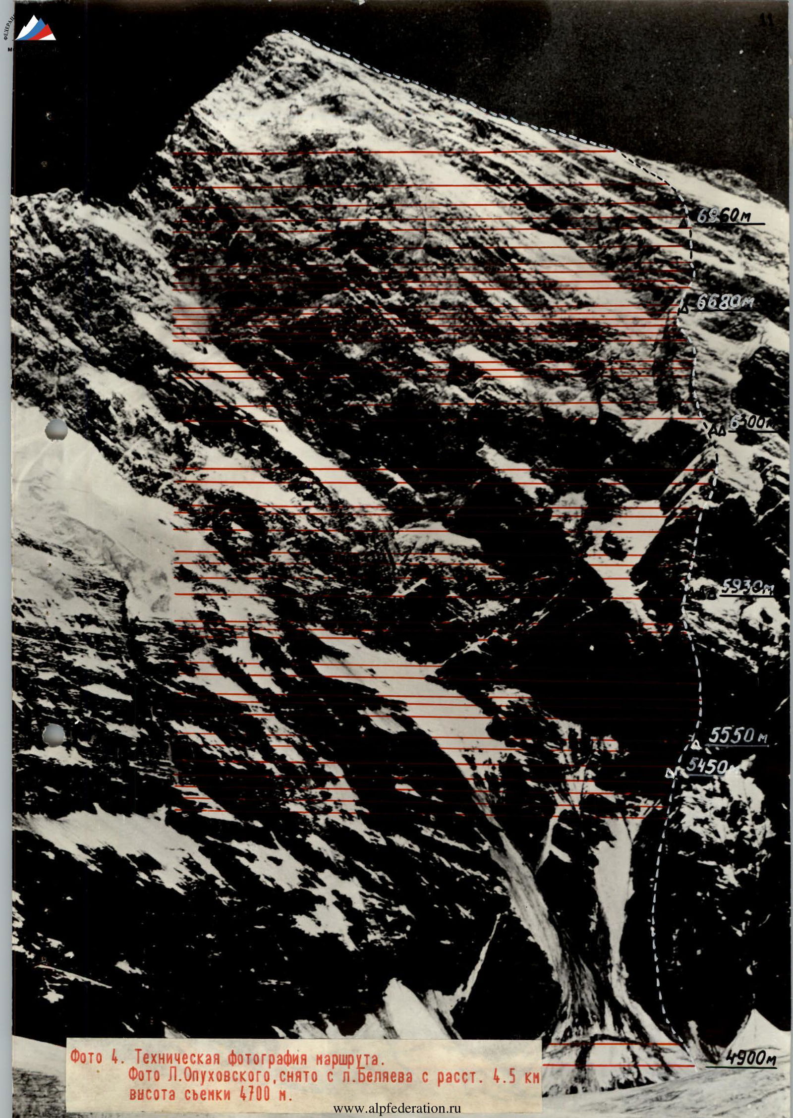
Photo 4. Technical photo of the route. Photo by L. Opukhovsky, taken from Belyaev peak from a distance of 4.5 km (elevation 4700 m).
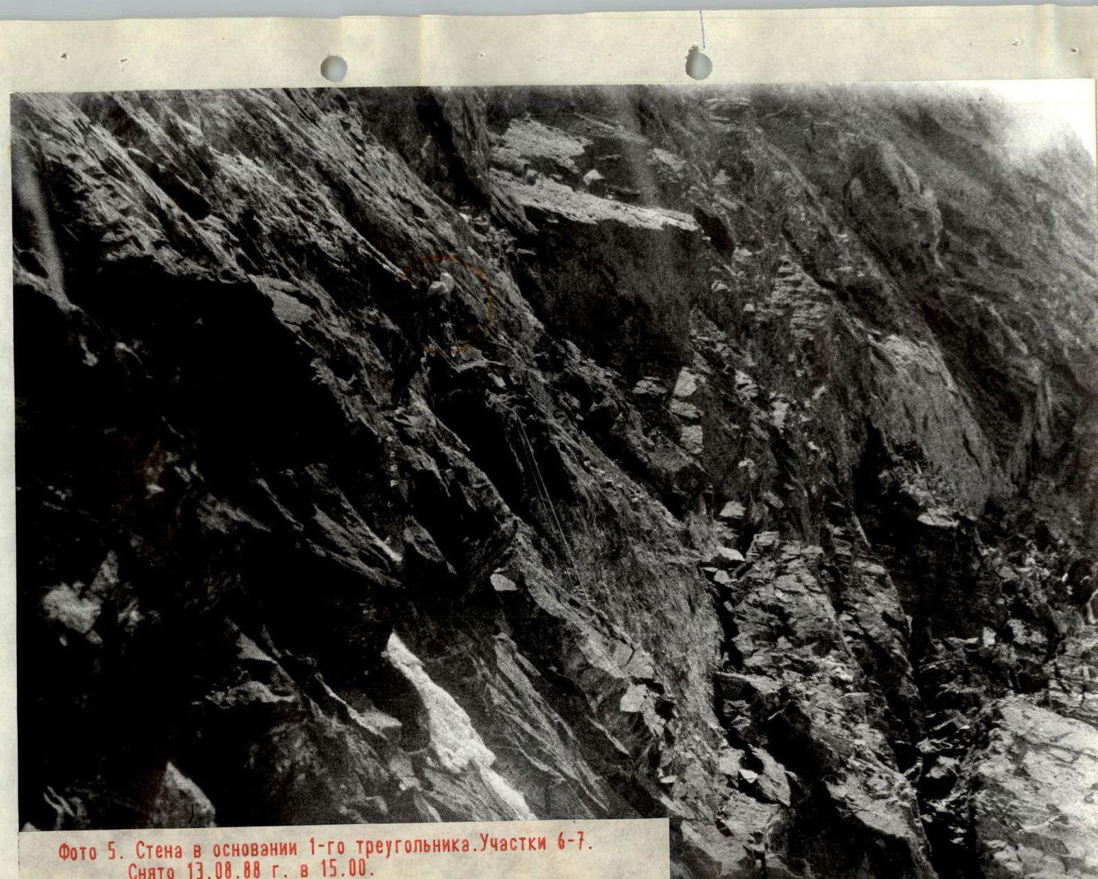
Photo 5. Wall at the base of the 1st triangle. Sections R6–R7. Taken on August 13, 1988, at 15:00.
Photo 6. Section R7–R8. Taken on August 13, 1988, at 16:00.
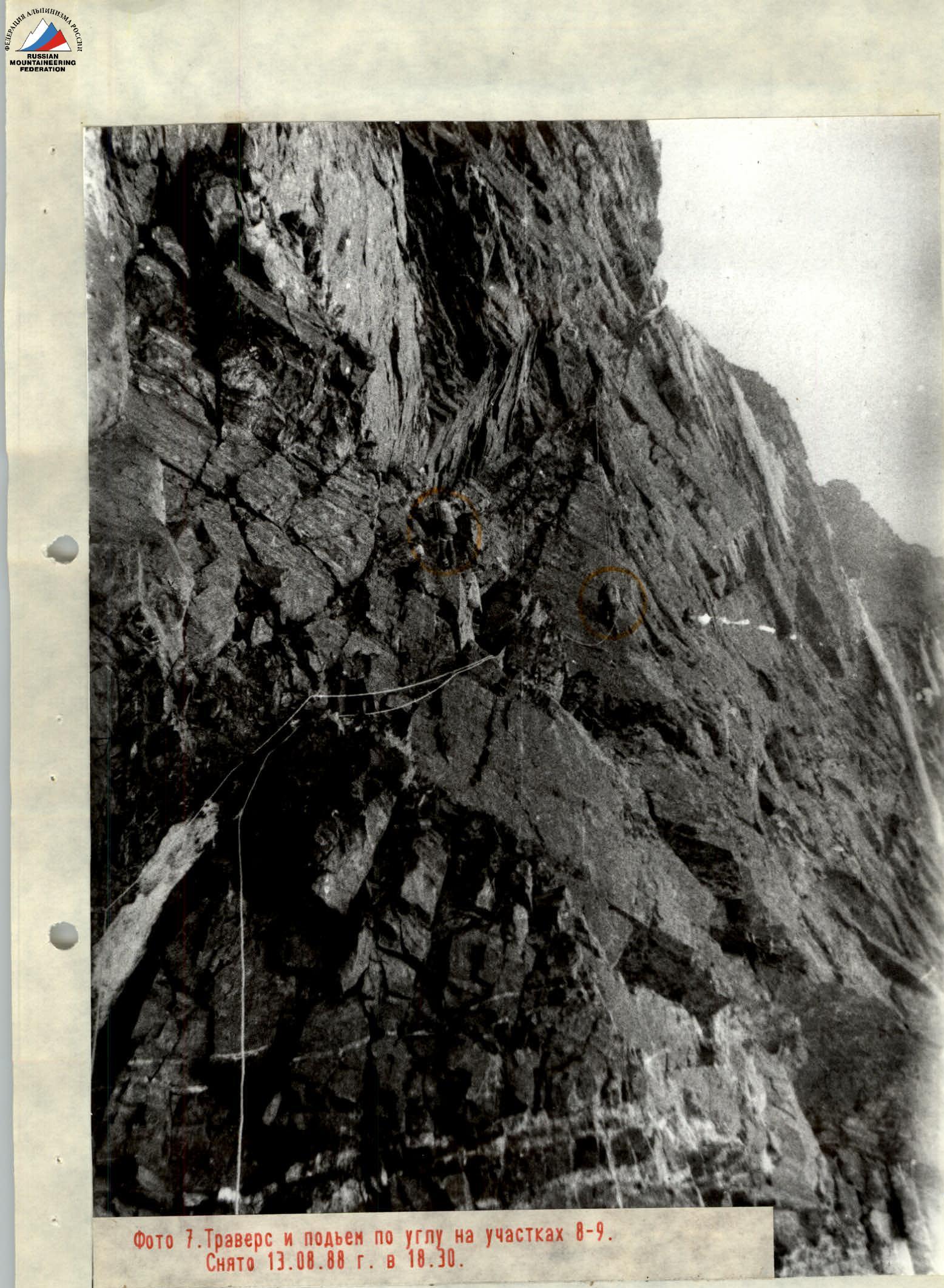
Photo 7. Traverse and ascent on the corner in sections R8–R9. Taken on August 13, 1988, at 18:30.

Photo 8. Section R23, passage of the processed path. The photo shows how sharply the ledge ends; the general profile of the wall is also visible here.
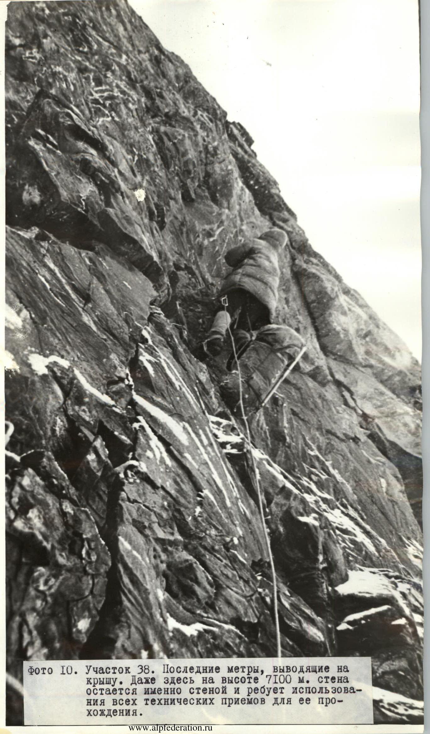
Photo 9. Section R38. Last meters leading to the "roof". Even here, at an elevation of 7100 m, the wall remains just that — a wall — and requires the use of all technical techniques to pass it.