Report
Ascent to Peak
Stalin
Group of CS SDSO "Burvestnik" Pamir, July – August 1961
Table of Contents
Introduction...........................................1 Brief Description of the Area............................1 Preparatory Period............................4 Assault.............................................11 1st Day..........................................12 2nd Day..........................................14 3rd Day..........................................16 4th Day..........................................19 5th Day..........................................21 6th Day..........................................23 7th Day..........................................25 8th and 9th Days.....................................25 General Characteristics of the Route......................27 Equipment........................................28 List of Participants in the Assault Group..................30
Introduction
In July and August 1961, the Central Council of the Student Voluntary Sports Society "Burvestnik" conducted a high-altitude expedition to the Pamir region in the area of the Bivachny Glacier. One of the main objectives of the expedition was to ascend to Peak Stalin (7495 m) via a new route. The expedition involved 19 climbers, including:
- Comrades Tamm E.I.,
- Comrade Smith V.A.,
- Comrade Bongard M.M.,
- Comrade Bragin O.V.
Brief Description of the Area
The Bivachny Glacier, where the expedition's base camp was located, is one of the largest tributaries of the Fedchenko Glacier. Bivachny flows from southwest to northeast and merges with the Fedchenko Glacier on its left (orographically) side, approximately 20 km from the tongue of the Fedchenko Glacier. In turn, the glaciers Kalinin, Stalin, and Molotov flow into Bivachny from the west and northwest. The Bivachny Glacier is sandwiched between the Akademii Nauk range to the north and northwest, the Darvaz range to the west, and the Fedchenko range to the south. The most significant alpinist interest in this area is drawn to the:
- Akademii Nauk range, which includes Peak Stalin (7495 m), Peak Molotov (6858 m), Peak Izvestiy (6840 m), and Peak Voroshilov (6665 m).
- Darvaz range, where Peak Garmo (6595 m) is located.

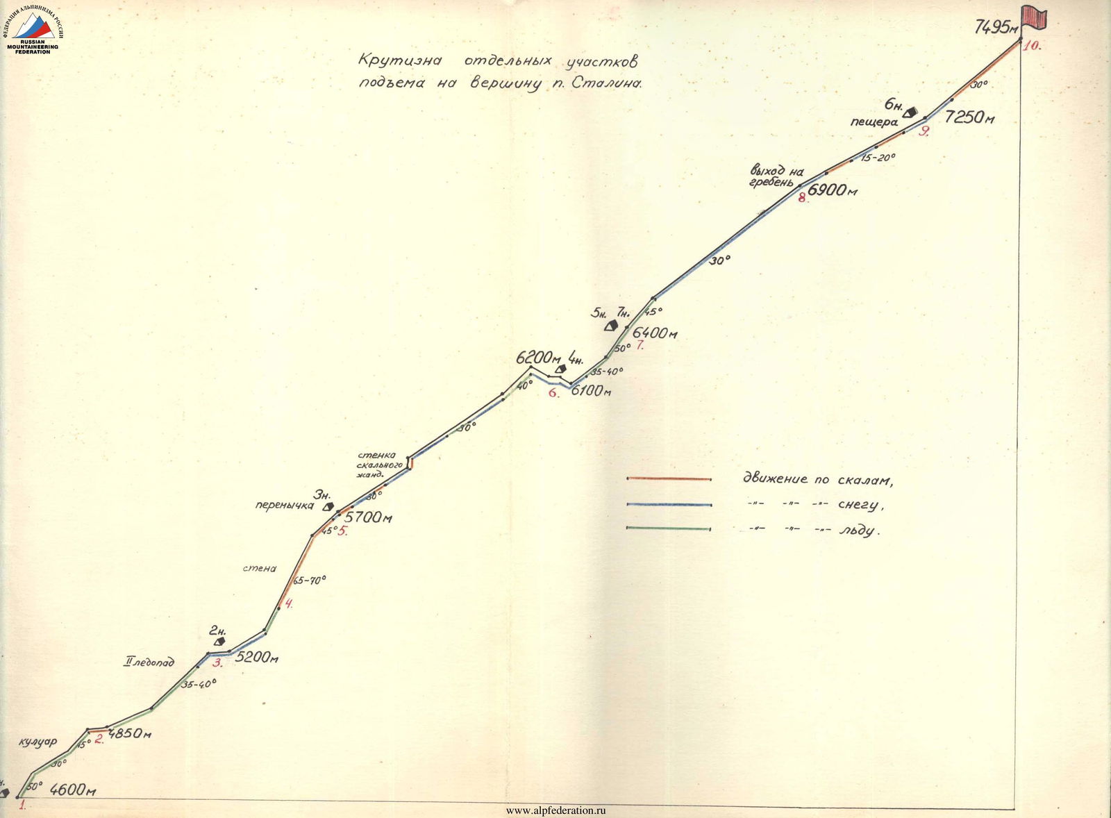
1–10. Parts of the route. 1–8 overnight stops.
Of the three major tributaries of the Bivachny Glacier, the Kalinin Glacier is the smallest. It has two distinct steps separated by a serac zone. The passage through this serac zone is extremely dangerous, as revealed by a reconnaissance conducted this year. The only possible bypass involves a multi-day, technically challenging traverse.
The next tributary, the Stalin Glacier, into which the Ordzhonikidze and Voroshilov glaciers flow, has been relatively well explored and visited by numerous expeditions that have ascended Peak Stalin, Peak Voroshilov, and Peak Ordzhonikidze. This year, ascents were made to Peak Krasnoy Armii and Peak Pioneer Pravdy, located between Peaks Izvestiy and Ordzhonikidze.
The Molotov Glacier, following the Stalin Glacier, is the largest of the tributaries. Until this year, it had not been visited by anyone. It arcs from the west to the north and has three distinct steps with powerful serac zones in between.
The Stalin and Molotov glaciers are separated by a long, highly serrated ridge, the uppermost point of which, named Peak Radioklub this year, has an elevation of 5800 m.
Preparatory Period
July 3. The expedition departed from Moscow. By August 8, the main contingent and all cargo had arrived in Daraut-Kurgan, but strong winds prevented the helicopter from flying out on the 8th or 9th.
July 10. The helicopter transported four people across the Muks-Su River along with some cargo. They proceeded up the Fedchenko and Bivachny glaciers to finalize the location for the base camp and receive the cargo, which was to be largely airdropped directly into the base camp.
July 11. The weather was cloudy, allowing the helicopter to transport people but not to drop cargo into the Bivachny Glacier. All but six people departed. These six remained to work on loading and dropping cargo. A second helicopter arrived.
July 12. The weather was ideal, but they ran out of fuel. The fuel tanker had gone to Osh. The six people sat idle, cursing the airport officials. The cargo was weighed; without personal belongings, it totaled 2.5 tons.
July 13. It was a "big helicopter day." The helicopters made six trips (three for us and three for the "Trud" expedition). As soon as one helicopter left, another was loaded.
The main cargo was dropped at the base camp.
July 14. The final drop was made. On the return trip, the helicopter picked up the remaining six people. An agreement was made with the pilots to meet at the same location on August 20. A farewell circle by the helicopter, and we were cut off from the rest of the world for a month. Communication was now only by radio. Loaded with items that couldn't be dropped (medications, fuel, etc.), the group headed to the base camp (at the confluence of the Bivachny and Stalin glaciers).
July 15. The entire expedition gathered at the base camp. They assessed the "shrinkage" and "loss" of cargo during the drop. All equipment was intact. Gas cylinders were dented, but the gas was preserved. They managed to recover 80% of the food supplies.
July 16. The camp was fully set up. Everyone headed to a panoramic viewpoint, a ridge on a peak above the camp. It took a couple of hours to ascend the slope and reach the ridge. Peak Molotov was clearly visible, along with the ridge that was to be ascended to reach the plateau between Peaks Molotov and Stalin.
July 17. Three groups set out on reconnaissance. Tamm, Bragin, Simolin, Smirnov, Florinisky, Kolodin, Baranov, and Milshtein headed to the Molotov Glacier to find a route to the upper cirque and then to the col between the Molotov and Stalin glaciers.
Vinokurov, Tkach, Dubinin, Efimov, Lyubimov, Kuznetsova, and Makora went to the Stalin Glacier to check if there was a route to the col from the north and to survey the southern ridges of Peak Stalin.
Bongard, Belopukhov, Tsetlin, Bozhukov, Zatrutina, and Goryacheva were to recon the Kalinin Glacier, as their backup plan was to ascend Peak Kalinin.
July 20. All groups returned to the base camp. It was decided that the Kalinin Glacier was not a viable option due to the danger of avalanches and difficult terrain.
The group led by Tamm found a route to the ridge of Peak Molotov from the south (via the Molotov Glacier), involving the passage of two complex serac zones and a wall leading to the ridge.
July 22. Bragin, Smirnov, Kolodin, Bozhukov, and Belopukhov set out on a second reconnaissance. Baranov, Dubinin, Bongard, Tkach, Florinisky, and Efimov ascended Peak Ordzhonikidze (6350 m).
July 25. Bragin, Bozhukov, Belopukhov, Smirnov, Kolodin, and Tsetlin set out on an ascent. They were to traverse via Peak Ordzhonikidze to Peak Izvestiy.
July 28. A group led by Bongard departed for the Molotov Glacier to set up an advanced base.
July 29. Kuznetsova, Goryacheva, and Makora returned to the base camp. The remaining group members ascended the couloir found by Tamm's group, stashed some gear, and prepared for further ascent.
July 31. The group led by Bongard reached the ridge. They encountered challenging ice and rock sections but successfully ascended.
August 1. The group began their descent, carefully navigating the couloir and icefall.
August 2. The group returned to the base camp. All participants in the future ascent were well acclimatized, having ascended peaks over 6300 m.
The preparatory period concluded. All necessary equipment was in place, and the team was ready for the ascent, pending suitable weather conditions.
Assault
The plan for ascending Peak Stalin, developed based on reconnaissance and consultation with participants of earlier expeditions, was as follows:
1st Day. Move from the base camp along the Bivachny Glacier upstream to the confluence with the Molotov Glacier. Pass the first serac zone of the Molotov Glacier on the right, near the boundary between the ice and rock. Overnight under the second step of the glacier.
2nd Day. Bypass the second serac zone via an ice couloir. The couloir is rockfall-prone after 7:00; the passage should start at dawn, with pairs moving simultaneously.
3rd Day. Ascend to the col between the Molotov and Stalin glaciers. Move in pairs with piton protection along the edge of the ice and rock.
4th Day. Traverse the plateau between Peaks Molotov, Pravda, and Stalin. Overnight on the plateau.
5th Day. Ascend the southwest ridge of Peak Stalin, pass the serac zone, and reach a height of around 7200 m. Overnight on the ridge.
6th Day. Reach the summit and descend to the plateau. Overnight on the plateau.
7th Day. Ascend to the shoulder of Peak Molotov and descend to the col, then to the third step of the Molotov Glacier.
8th Day. Return to the base camp on the Bivachny Glacier.
9th Day. Reserve day.
August 7. The group departed the base camp at 10:00. They followed the planned route, navigating through the Bivachny and Molotov glaciers.
August 8. The group passed the ice couloir and continued up the glacier, establishing their second camp.
August 9. They ascended the wall leading to the col between the Molotov and Stalin glaciers, a technically challenging section.
August 10. The group traversed the snowy and icy ridge to reach the plateau.
August 11. They ascended the serac zone on the southwest ridge of Peak Stalin and established their fifth camp at around 6400 m.
August 12. The group ascended further, navigating steep ice and snow slopes, and established their sixth camp at around 7200–7300 m.
August 13. They reached the summit of Peak Stalin. Visibility was excellent, and they found a note left by Cassin.
August 14–15. The group descended, carefully navigating the serac zones and couloirs, and returned to the base camp.
The ascent took 9 days, with 74 man-hours of climbing, of which 46 hours were spent ascending and 28 hours descending. The height difference from the base camp to the summit was approximately 3700 m.
Throughout the ascent, all participants demonstrated good technical preparation and excellent acclimatization.
General Characteristics of the Route
The route taken by the group of the Central Council of SDSO "Burvestnik" starts from the Bivachny Glacier at its confluence with the Molotov Glacier. The most technically challenging section is the ascent to the plateau at a height of 6200 m.
The route is a combination of rock and ice climbing, with the most difficult section being the wall leading to the col between the Molotov and Stalin glaciers (category 4B).
Equipment
The group was well-equipped with necessary gear, including high-altitude tents, warm clothing, and sufficient food and fuel.
The equipment used included:
- 3 high-altitude tents made of colored, waterproofed canvas
- Warm clothing, including down jackets and sleeping bags
- Crampons and ice axes
- 20 rock pitons and 15 ice pitons
- 3 "Febus" type primus stoves with high-quality fuel
The group's equipment was in good condition, and they had no cases of frostbite.
List of Participants in the Assault Group
| № | Name | Year of Birth | Nationality | Party Membership | Sports Rank | Alpine Experience | Main Profession | Address |
|---|---|---|---|---|---|---|---|---|
| 1 | Tamm Evgeny Igorevich | 1926 | Russian | Non-party | 1st Sports Rank | Since 1947 | Researcher | Moscow, M. Gorky embankment, 4/22, apt. 63. |
| 2 | Smith William Arturovich | 1930 | Russian | Non-party | Master of Sports | Since 1951 | Researcher | Moscow, Chistye Prudy, 1st, apt. 42. |
| 3 | Bragin Oleg Vladimirovich | 1931 | Jewish | Non-party | 1st Sports Rank | Since 1952 | Researcher | Moscow, Mira Ave., 108, apt. 56. |
| 4 | Bongard Mikhail Moiseevich | 1924 | Jewish | Non-party | Master of Sports | Since 1949 | Researcher | Moscow, 4th Tverskaya-Yamskaya, 20, apt. 42. |
| 5 | Smirnov Yuri Ivanovich | 1931 | Russian | Non-party | 1st Sports Rank | Since 1956 | Researcher | Moscow, City of Moscow Soviet, 1st passage, 16, apt. 64. |
| 6 | Tsetlin Valentin Mikhailovich | 1927 | Jewish | Non-party | 1st Sports Rank | Since 1957 | Researcher | Moscow, Tolbuzin St., 3/2, apt. 29. |
| 7 | Dubinin Vadim Alekseevich | 1934 | Russian | Komsomol | 1st Sports Rank | Since 1952 | Researcher | Moscow Region, Dolgoprudny, MFTT hostel, "V". |
| 8 | Baranov Boris Sergeevich | 1932 | Russian | Non-party | 1st Sports Rank | Since 1952 | Engineer | Moscow, 9th Proezd, 23, apt. 11. |
| 9 | Bozhukov Valentin Mikhailovich | 1933 | Russian | Komsomol | Master of Sports | Since 1953 | Engineer | Moscow, Pisatsova St., 16/45, apt. 176. |
| 10 | Belopukhov Andantin Konstantinovich | 1929 | Russian | Non-party | Master of Sports | Since 1948 | Engineer | Moscow, Uzkoye, 25, apt. 5. |
| 11 | Kolodin Vladimir Alekseevich | 1926 | Russian | Non-party | Master of Sports | Since 1947 | University Lecturer | Alma-Ata, Kalinin St., 83, apt. 50. |
| 12 | Vinokurov Vladimir Konstantinovich | 1929 | Russian | CPSU | Master of Sports | Since 1951 | Engineer | Moscow, Studencheskaya, 42, apt. 55. |
| 13 | Florinisky Arnold Borisovich | 1933 | Russian | Non-party | Master of Sports | Since 1953 | Engineer | Moscow, Lefortovsky Val, 7/6, apt. 4. |
| 14 | Tkach Vadim Borisovich | 1932 | Ukrainian | Non-party | Master of Sports | Since 1952 | Engineer | Moscow, Khomnichesky Tupik, 4, apt. 7. |
| Date | Sections Covered | Average Steepness | Height Difference | Terrain Character | Technical Difficulty | Insurance Method | Weather | Departure Time | Stop Time | Climbing Hours | Pitons Driven Rock: Ice | Camping Conditions | Daily Ration Weight |
|---|---|---|---|---|---|---|---|---|---|---|---|---|---|
| Aug 7 | R1–R2 | 40° | 250 m | Ice Couloir | 4 | Rock Piton, Protrusions | Good | 4:30 | 14:00 | 7 h | 1 : — | Good | 1.5 kg × 14 |
| R2–R3 | 35° | 350 m | Serac Zone | 4 | Glacier Bends, Ice Pitons | — : 2 | |||||||
| Aug 9 | R3–R4 | 25–50° | 100 m | Snow, Ice | 4 | Rock Pitons | Good | 7:00 | 15:00 | 8 h | 2 : — | Good | 1.2 kg × 14 |
| R4–R5 | 65° | 400 m | Loose Rocks | 4 | Rock Pitons | — : 2 | |||||||
| Aug 10 | R5–R6 | 30° | 700 m | Snow-Ice Ridge | Rock Protrusions | Snowfall from 12:00, Fog | 9:00 | 14:00 | 5 h | — : — | Good | 1 kg × 14 | |
| Rock "Gendarmes" | 3 | ||||||||||||
| Aug 11 | R6–R7 | 35–50° | 200 m | Snowy Serac Zone | 4 | Ice Axe, Ice Pitons | Fog | 9:00 | 17:00 | 8 h | — : 3 | Good | 1 kg × 14 |
| Aug 12 | R7–R8 | 45–50° | 500 m | Ice, then Snow Slope | 3 | Ice Pitons, Ice Axe | Clear. Strong Wind | 7:00 | 15:00 | 8 h | — : 3 | Cave | 0.7 kg × 14 |
| R8–R9 | 20° | 300 m | Sharp Snow Ridge | 3 | Ridge Bends | ||||||||
| Aug 13 | R9–R10 | 30° | 300 m | Snowy Rocks | 2 | Alternating Movement | Good | 8:00 | 16:30 | 8.5 h | — : — | Camp 5 | 1 kg × 14 |
| R10–R7 | |||||||||||||
| Group Leader E. Tamm |