1917–1967
In honor of the 50th anniversary of the Great October Socialist Revolution
Report
on the ascent of Peak Communism (7495 m) from the Bivachny glacier by the sports team of the Dnepropetrovsk Regional Sports Union. Materials for the USSR Climbing Championship 1967. Dnepropetrovsk 1967
 Thus, the final composition of the assault group after adjustments was as follows:
- Sinkovsky A.B. — MS — captain
- Zaydler A.M. — MS — participant
- Pechenin V.M. — MS — participant
- Verbitsky G.G. — CMS — participant
- Shabokhin V.A. — CMS — participant
- Dubinin V.N. — CMS — participant
- Vitko A.P. — CMS — participant
- Grabar I.A. — 1st sports category — participant
Ascent route to Peak Communism
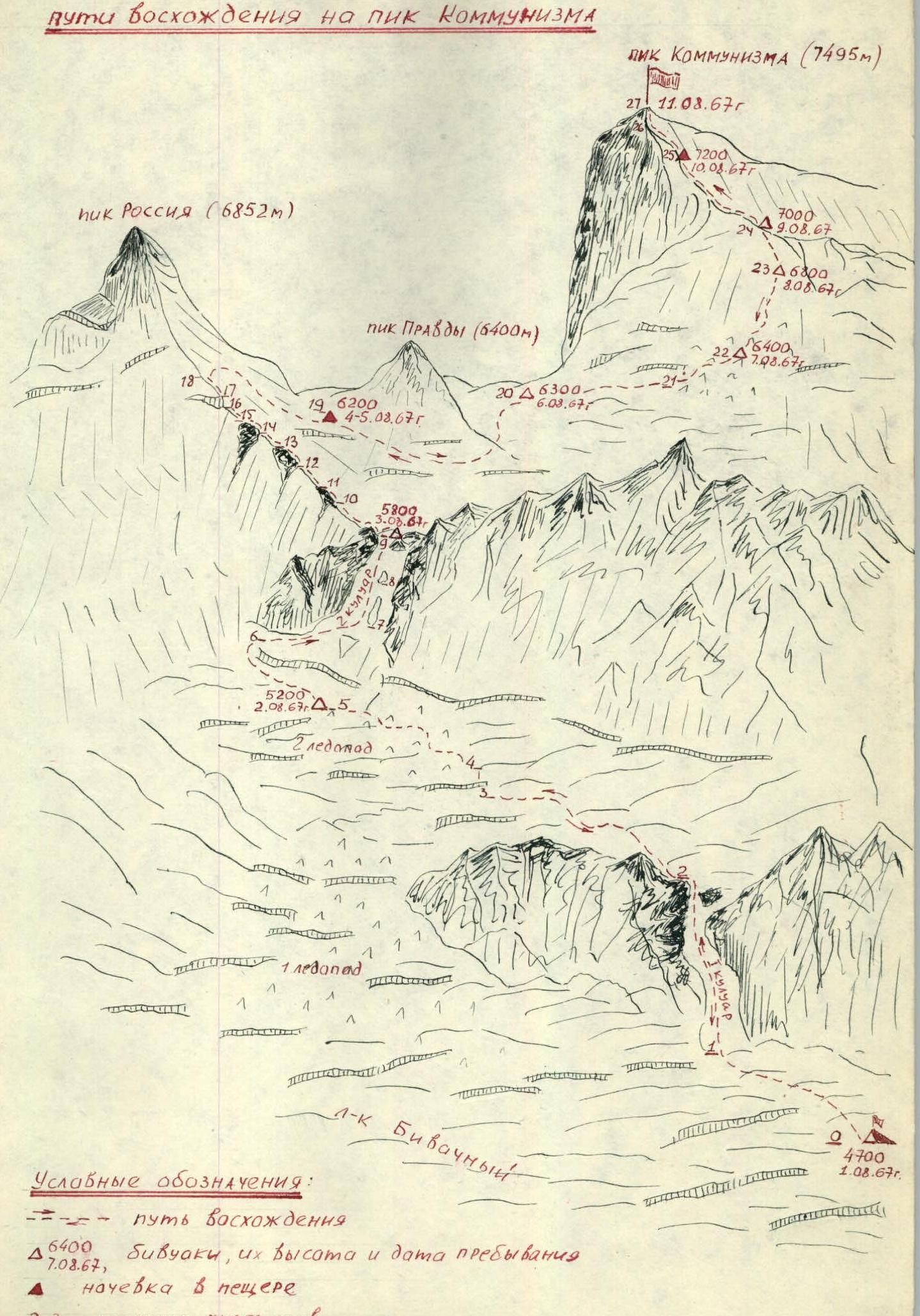 From July 22 to August 1, 1967, a base camp "3600", intermediate camps "3900", "4200", "4700", "5200", "5800" were set up, and the path to the "6200" plateau was scouted and marked. During this time, all expedition participants underwent sufficient acclimatization and, after a two-day rest at the ice camp "4700", were ready to undertake the ascents according to the expedition plan. August 1. Excellent weather. Rise at 4:00. Quickly prepare breakfast, dismantle camp, and at 5:00, 17 expedition members (10 main group and 7 support group) left camp "4700". Half an hour later, they approached the couloir and, after a short rest, began ascent through it, bypassing the 1st step of the icefall. They moved in crampons, on steps, and held onto pre-installed safety ropes. At 7:00, all participants gathered at the top of the couloir, where they were greeted by the first rays of the sun, and the couloir, now under the threat of rockfall, became practically impassable during the day.
After 1.5 hours, moving across the closed glacier in teams, they approached the second step of the icefall, rested briefly, and continued forward. The glacier was heavily broken, and they had to navigate through closed crevices. A key spot was a 25-meter ice wall that needed to be traversed. The ascent routes were mainly snow-ice, with some rocky sections of medium difficulty, heavily destroyed and composed of schist rocks. The height difference from the ice camp "4700" to the summit was 2795 m. It was challenging to pinpoint the most difficult sections as they were scattered throughout the route and were more numerous than the easier ones. The entire route was considered challenging, except for the plateau at 6200 m between the slopes of Peak Russia and Peak Communism. The steepness of the route was also hard to determine due to the varying directions of movement, but sections with a slope of approximately 40–45° prevailed.
The table of main characteristics is as follows:
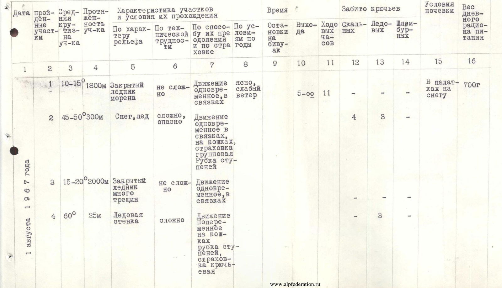
| Sect. № | Steepness | Length | Terrain character | Technical difficulty | Method of overcoming and belay | Biwak stops | Departures | Working hours | Rock | Ice | Pitons | Camping conditions | Ration, g |
|---|---|---|---|---|---|---|---|---|---|---|---|---|---|
| August 1, 1967 | |||||||||||||
| 1 | 10–15° | 1800 m | Closed glacier, moraine | not difficult | Simultaneous movement, in teams | 5:00 | 11 | – | – | – | – | In tents on snow | 700 |
| 2 | 45–50° | 300 m | Snow, ice | difficult, dangerous | Simultaneous movement in teams, in crampons, group belay, step cutting | – | – | – | 4 | 3 | – | – | – |
| 3 | 15–20° | 2000 m | Closed glacier, many crevices | not difficult | Simultaneous movement, in teams | – | – | – | – | – | – | – | – |
| 4 | 60° | 25 m | Ice wall | difficult | Alternating movement, in crampons, step cutting, piton belay | – | – | – | – | 3 | – | – | – |
| August 2, 1967 | |||||||||||||
| 5 | 45° | 400 m | Icefall | difficult, dangerous | Alternating movement in teams, in crampons, piton belay and through ice axe | 16:00 | – | 5 | – | – | – | In tents, on ice | 700 |
| 6 | 20–25° | 1500 m | Closed glacier | not difficult | Simultaneous movement, in teams | 5:00 | 12 | – | – | – | – | – | – |
| 7 | 45° | 180 m | Snow-ice slope | difficult, dangerous | Alternating movement in teams, step cutting, piton belay | – | – | 5 | 4 | – | – | – | – |
| 8 | 45° | 250 m | Rocks, ice slope | difficult | Alternating movement, in crampons, step cutting. Pitons belay | – | – | 7 | 5 | – | – | – | – |
| 9 | 50° | 200 m | Snow-ice slope | difficult | Alternating movement in crampons, step cutting. Pitons belay | 17:00 | – | 2 | 6 | – | – | – | – |
| August 3, 1967 | |||||||||||||
| 10 | 15–20° | 1500 m | Snow ridges | not difficult | Mostly simultaneous movement, in teams. Belay through ice axe | 9:00 | 6 | – | – | – | – | In caves | 700 |
| 11 | 25° | 40 m | Destroyed rock ridge | not difficult | Alternating movement, piton belay | – | – | – | 2 | 1 | – | – | – |
| 12 | 20° | 60 m | Snow ridge | not difficult | Simultaneous movement | – | – | – | – | – | – | – | – |
| 13 | 45° | 35 m | Rocks of medium difficulty, destroyed | not difficult | Alternating movement. Pitons belay | – | – | – | 3 | – | – | – | – |
| 14 | 35° | 80 m | Snow ridge | not difficult | Alternating movement, belay through ice axe | – | – | – | – | – | – | – | – |
| 15 | 45° | 70 m | Rocks of medium difficulty | not difficult | Alternating movement, piton belay | – | – | – | 5 | 1 | – | – | – |
| 16 | 40° | 200 m | Snow-ice ridge | difficult | Alternating movement, piton belay and through ice axe. Step cutting | – | – | – | – | 4 | – | – | – |
| 17 | 60° | 5 m | Ice wall and crevice | difficult, dangerous | Alternating movement, piton belay, step cutting | – | – | – | – | 3 | – | – | – |
| August 9, 1967 | |||||||||||||
| 24 | 40–45° | 160 m | Snow-ice slope | difficult | Alternating movement in crampons, piton belay and through ice axe | 16:00 | 12:00 | – | 4 | 4 | – | In tents on snow | 700 |
| August 10, 1967 | |||||||||||||
| 25 | 30–35° | 300 m | Snow ridges, outcrops of medium and heavily destroyed rocks | difficult | Alternating movement, belay through ice axe | 14:00 | 10:00 | – | 4 | – | – | In a cave | 700 |
| 26 | 35–40° | 150 m | Snow ridge gradually turning into a slope | not difficult | Alternating movement, belay through ice axe | 19:00 | 11:00 | 8 | – | – | – | In tents on snow | 700 |
| 27 | 35–40° | 150 m | Heavily destroyed rocks of medium difficulty, snow-covered, with 3–5 m walls | difficult | Alternating movement, belay through outcrops | – | – | – | – | – | – | – | – |
Prose continues here:
...move along the steep chute, about 1.5 m wide. Here we cut steps and drive in 3 ice screws. The teams move along the pre-installed safety ropes. Further, the path goes along a 45°, and in the upper part, perhaps all 50°, ice slope covered with a thin layer of snow. The length is 300 m, with piton belay. Movement is hampered by the fact that today the weather is very good, the sun shines and heats mercilessly, there is almost no wind, and the snow is very soggy. It is hard to move. Just before exiting onto the plateau, there is a huge crevice with a small snow bridge. At 15:00, we exit onto the plateau. After another hour of movement across the glacier, we approach a depression where a cache is left, dig out platforms for tents, and stop for the night — this is our intermediate camp "5200".
August 2
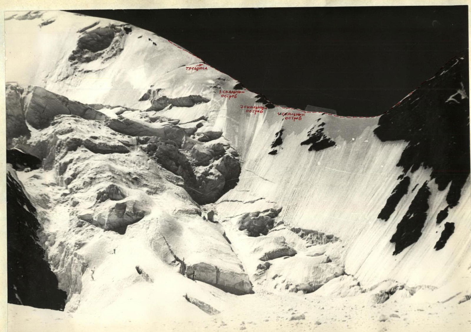
The weather is good, slight cloudiness, no wind. Departure at 5:00. After 1.5 hours of movement across the closed glacier, holding to the slopes of Peak Radio, we approach the bergschrund. Through an old avalanche cone that blocked the bergschrund in one place, we pass it and move along a 35° snow-ice slope towards the first rocky outcrop dividing the couloir into two parts, bypassing it from the left. Then we cross the couloir towards the second rocky outcrop. Here we cut steps and use piton belay. Moreover, due to the destroyed rocks, we have to drive in several pitons, blocking them together — one piton is unreliable. We also bypass the second rocky outcrop from the left, sticking to the rocks. Then we ascend directly up the ice slope to the third outcrop. Here we have to:
- install safety ropes;
- cut steps;
- drive in ice screws (instead of one, two, because the ice has become loose and waterlogged).
The ascent with heavy backpacks is very difficult and exhausting. From the third rocky outcrop, we move directly up the snow-ice slope towards a clearly marked depression in the ridge. The movement is also along safety ropes and in crampons with step cutting, and by 17:00, everyone gathers on the ridge. Here, in a small depression, there is a pond and platforms in the ice that we dug during the reconnaissance. We stop for the night — this is the intermediate camp "5800".
August 3
- Rise at 8:00, departure at 9:00. It's too cold to leave earlier.
- The weather is not very pleasant: average cloudiness and strong wind.
- Movement initially occurs along snowy, sharp ridges.
- After 1.5 hours, we reach the saddle between Peaks Radio and Russia.
- After a short rest, we continue moving — now along the edge of Peak Russia.
The edge is not difficult. We move simultaneously. There are three rocky outcrops on the ridge that we pass with piton belay.
- Initially, the steepness of the ridge is about 15–20°.
- After the second rocky outcrop, the steepness increases to 45° — here we move with alternating belay.
After the third rocky outcrop, the edge is broken by a crevice, and we need to overcome:
- an ice wall about 5–6 m high;
- a 3-meter crevice.
The first, fragile bridge still held, but the second collapsed under us, though the belay was reliable, and everything turned out okay. The heavy backpack and already significant altitude — 6000 m — are felt.
August 4
The bad weather continues throughout the day, so we have to stay in the cave. During the day and night, we had to clear snow from the entrance several times.
August 5
By morning, the bad weather began to subside, so we decided to continue our work according to the plan. At 11:00, two groups departed: Zaydler, Vitko, Grabar under the leadership of Shabokhin, and Sinkovsky, Pechenin, Dubinin under the leadership of Verbitsky to Peak Pravdy. We decided to do a kind of warm-up after sitting in the cave, to better examine the route through the icefall on the slopes of Peak Communism, and also to further acclimatize the members of the assault group. At 18:00, both groups descended from Peak Pravdy. On the same day, another group from among the support team under the leadership of Zyuzin ascended Peak Pravdy. By 18:00, they also descended to the cave. The weather improved noticeably.
August 6
The weather is good, but very cold. In the morning, a final medical examination of the assault group members was conducted. Artyushenko and Zyuzin V. were disqualified from ascending Peak Communism by the expedition doctor, Comrade Mitsenko M.D., due to health reasons. At 11:00, 8 members of the assault group:
- Sinkovsky A.
- Zaydler A.
- Pechenin V.
- Shabokhin V.
- Verbitsky G.
- Dubinin V.
- Vitko A.
- Grabar I.
Began moving towards Peak Communism across the plateau. Initially, they followed their tracks to Peak Pravdy and then chose a path among numerous crevices. At 18:00, they stopped for the night in the immediate vicinity of the icefall on the slopes of Peak Communism.
August 7
They departed at 9:00. After 1.5 hours of movement, they approached the icefall, rested briefly, and continued forward. The steepness of the icefall is approximately 45°. They moved in turns, cutting steps and driving in pitons for piton belay. There were complex sections: ice walls, steep inclined shelves; the entire route required careful belay. At 17:00, at a height of approximately 6400 m, they decided to spend the night in a small depression with a flat bottom, where both tents were conveniently set up. The duo (Shabokhin and Pechenin) went ahead to process the remaining part of the icefall while the others set up camp. After installing ropes, they returned to camp by 20:00. At 21:00, they fired a green flare for their observers. Far below, a return flare described an arc and faded.
August 8
Departure at 10:00. Cloudy, strong wind, very cold. Moving along the path processed the day before, they traversed the remaining part of the icefall in 2 hours and exited onto a steep snow-ice slope. Movement in crampons, alternating — it was steep, and the backpacks were heavy, so they decided to proceed cautiously. The snow sometimes sank above the knees, and at other times, there were snow boards where even the teeth of crampons left almost no marks. At 18:00, they stopped for the night directly on the slope, having first cut out a platform for two tents. They were very tired by the end of the day. The height was 6800 m.
August 9
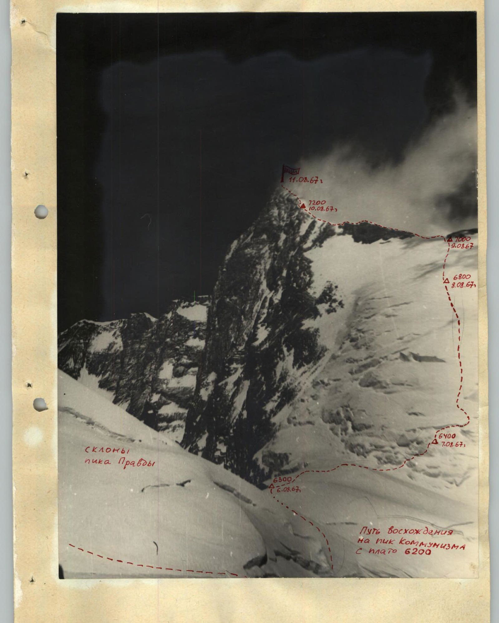
At night, a strong wind arose, and by morning, it had strengthened even more, blowing snow into their faces, and it was cold. They departed only at 12:00. Movement was directly up the slope with a slight traverse to the left towards the edge of Peak Communism. Their task for the day was to reach the edge and stop there for the night.
They moved in crampons, with alternating belay, and within 4 hours reached the saddle in the ridge. To the left, the ridge led to the summit, and to the right, there were rocks, and under them, an excellent depression well-protected from the wind. The height was 7000 m, where they organized another night's stay. They spent the night in tents.
August 10
After resting well and eating, at 10:00, they dismantled camp and began moving along the ridge. The ridge was snowy and consisted of several ascents. There were outcrops of medium-difficulty rocks. The temperature gradually dropped, and the wind strengthened. After an hour of ascent, it became very difficult to move due to the strong headwind. They frequently stopped to warm their fingers and toes. All this slowed their movement. They moved mostly simultaneously, changing leaders every 8–10 minutes. The high altitude was felt, and the summit was still far away. By 14:00, the weather had deteriorated completely. It started snowing, and visibility was lost. They decided to stop for the night immediately. The height was 7200 m; they dug a cave. It was difficult, but they worked persistently — standing still could result in freezing. After 2 hours, the cave was ready, and the bad weather was no longer a threat. They could lie down slightly curled up, with their legs tucked in. For such a high altitude, the overnight stay was excellent.
August 11
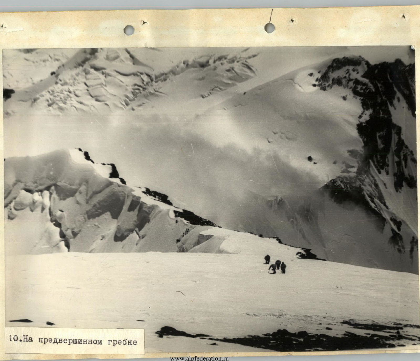
After digging out in the morning and exiting the cave, they were rewarded with a magnificent panorama. The sun was out, with a moderate wind, occasionally strengthening. The summit was about 300 m higher; the weather was good, so they decided not to take tents but only warm clothing and a little food. They left the overnight stay at 11:00, moving at a good pace. The movement was simultaneous. Initially, the ridge was quite broad; outcrops of rocks appeared on the left, where they could rest. Higher up, there were rocks of medium difficulty, but at such an altitude, they were very challenging to overcome, requiring a lot of effort and time to organize belay, but it was necessary. After passing the rocks, they reached a small rock wall 3–4 m high and, having overcome it, reached the summit at 15:00.
On the summit:
- They found a note from the advance group of the Ukrainian expedition from 1966.
- Left their own note, a banner from the workers of Dnepropetrovsk, and a bust of V.I. Lenin.
- Conducted film and photo shooting.
At 16:00, they began their descent and, by 19:00, having passed the "7200" camp, arrived at the "7000" camp, where they stopped for the night.
August 12
Departure at 9:00. They continued their descent. At 12:00, they approached the icefall, moving along the familiar path, alternating. At 19:00, they passed the icefall and descended onto the "6200" plateau. Here, near the slopes of Peak Pravdy, they were met by the observation group with hot tea and congratulations, for which they expressed gratitude to their comrades-observers: doctor Mitsenko, participants Prudnikov and Malyarenko. They organized an overnight stay directly on the plateau.
August 13
They continued moving down. After 2 hours, they approached Peak Russia, ascended along the slope to the edge, and then down to the saddle. The descent took 3 hours. At 14:00, they began descending through the couloir. The descent was along safety ropes, and by 20:00, they stopped for the night at camp "5200".
August 14
They descended to camp "4700". The descent took a whole day because they had to wait until sunset, sitting at the entrance to the couloir.
August 15
They liquidated camp "4700" and began descending to the base camp "3600", which they reached the following day.
August 16
They liquidated the base camp and descended to the 3200 m site, from where they would be transported by helicopter to the village of Darout-Kurgan the next day.
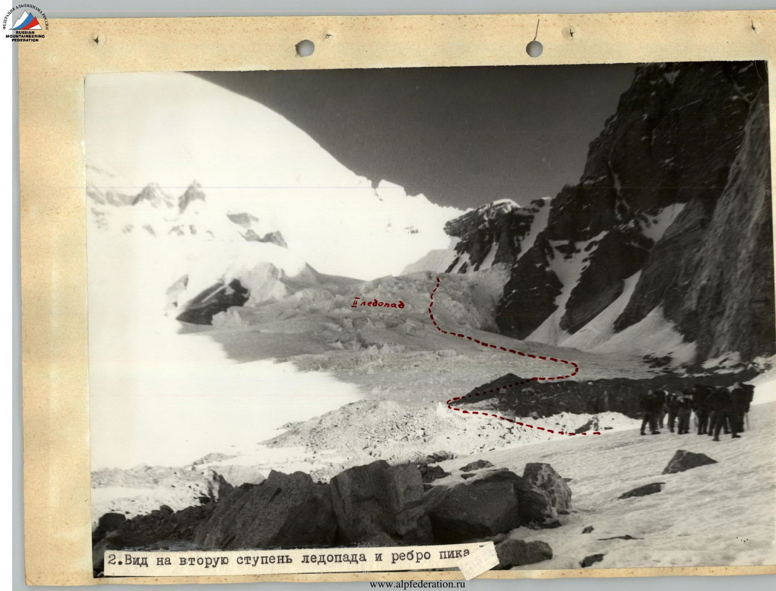 2. View of the second step of the icefall and the edge of the peak.
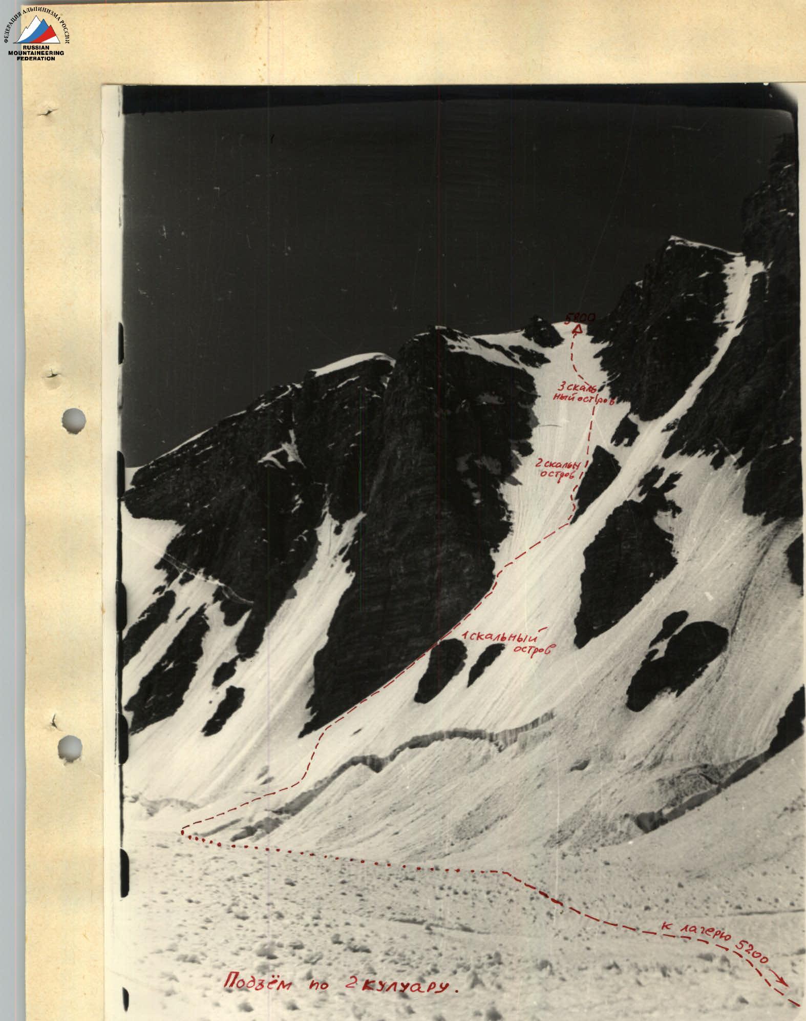 3. Ascent through the second couloir to the saddle between Peak Radio and Peak Russia.
 Edge of Peak Russia.
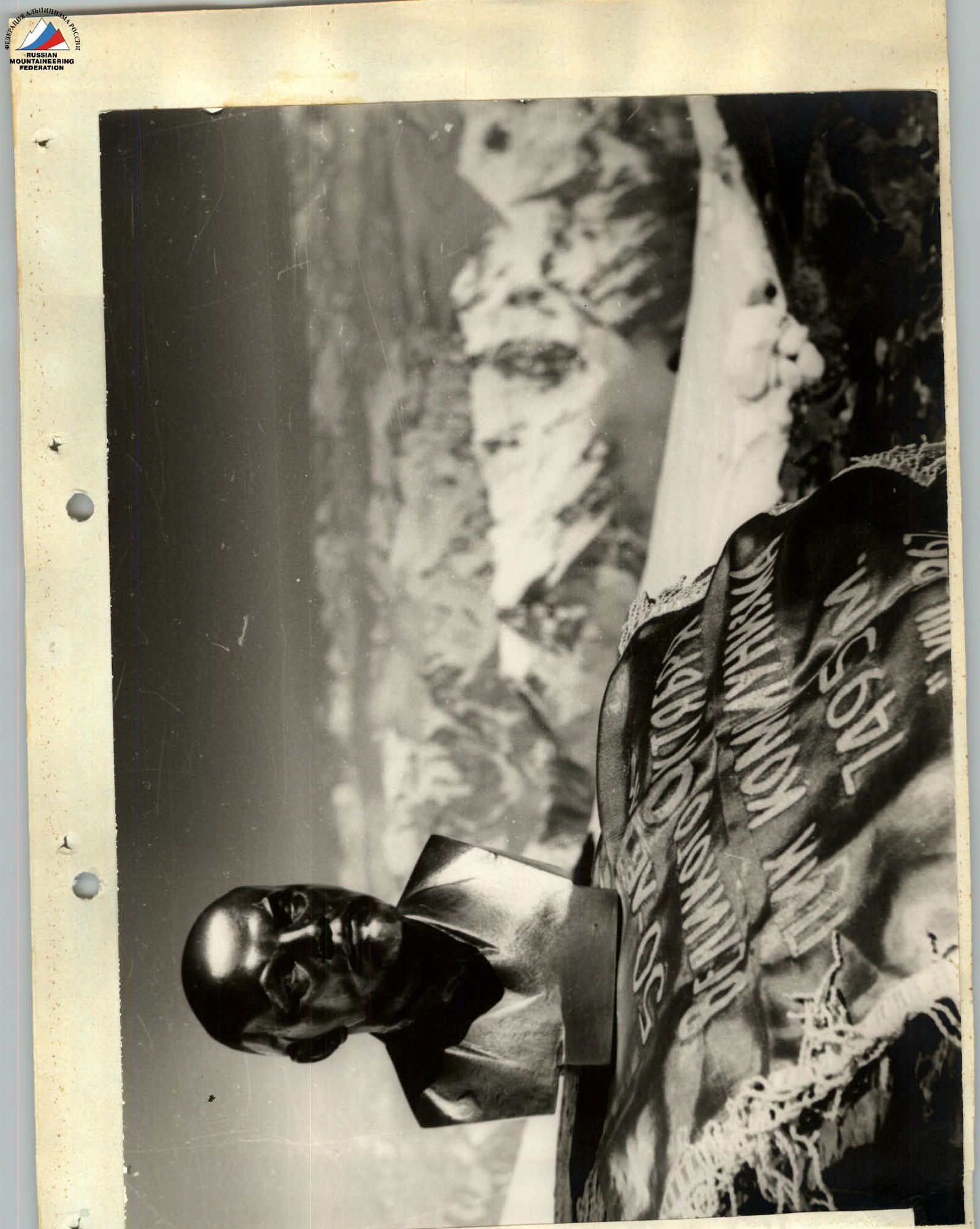 11. Bust of V.I. Lenin and the jubilee pennant installed by Dnepropetrovsk climbers on the summit of Peak Communism in honor of the 50th anniversary of Soviet power.