Passport
I. High-altitude class 2. Pamir, Akademiya Nauk range 3. Peak Kommunizma 7495 m via the left counterfort from Stalin Glacier 4. Proposed — category 5B difficulty, second ascent 5. Elevation gain: 2895 m, length — 5300 m Elevation gain of the rocky section — 1780 m, length of the rocky section — 2320 m Length of category 5 sections — 540 m, average steepness of the rocky part of the route — 51° 6. Pitons hammered: rock — 23, chocks — 214, ice screws — 33 7. Team's travel time: 35 hours, days — 3.5 8. Overnights: 1 — semi-reclined; 2–3 — reclined 9. Leader: Vorobyev Pavel Aleksandrovich Team members:
- Ismetov Malik Magzhanovich (Candidate for Master of Sports)
- Martirosov Ashot Robertovich (Candidate for Master of Sports)
- Maydanyuk Vladimir Ivanovich (Candidate for Master of Sports)
- Krivosheev Gennadiy Stanislavovich (Candidate for Master of Sports)
- Savina Lyudmila Nikolaevna (Candidate for Master of Sports)
- Coach: Ilyinsky E.T., Master of Sports of International Class, Honored Coach of the USSR
- Departure to the route: August 14, 1992 Summit: August 17, 1992 Return: August 19, 1992
- Organization: Ministry of Tourism and Sports of the Republic of Kazakhstan
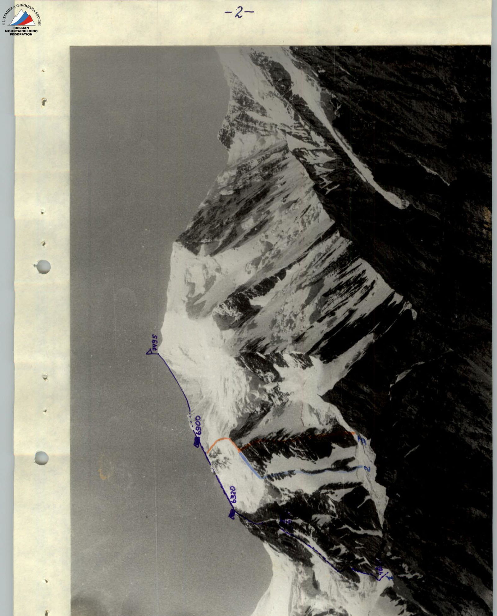
General photo of the route
- Lunyakov's team route
- Kustovsky's
- Budanov's
Brief overview of the climbing area
The area of Bivachny and Stalin glaciers is popular and frequently visited. Eight routes have been laid from this side to Peak Kommunizma (including the routes of the first ascenders). The team of the 12th Mountaineering Club of the SAVO worked in this area in 1975 and 1979, and made ascents to Peak Akhmadonisha, Peak Rosash, Peak Kommunizma via Abalakova and Tamm's route, and other peaks. Even during these expeditions, attention was drawn to the fact that from this side there is an unclimbed counterfort, along which it is logical to lay a logical independent route.
The ascent area was well studied by the team members.
Brief description of the approach to the route.
The approach to the route from the base camp on Bivachny Glacier at an altitude of 3700 m passes along the right (orthographically) "pocket" of Bivachny Glacier. After an hour's movement along the "pocket", the crossing of Bivachny Glacier begins under the beginning of the ridge of Peak Radioklub ("Shirma"). Then we go around the "Shirma" and start climbing along the "Shirma" along the "pocket" of Stalin Glacier and reach the main slopes (beaten path) up to the helicopter pad at 4200 m (1.5–2 hours).
From the helicopter pad, the path again leads into the "pocket" of Stalin Glacier, and then moves up to its end and reaches the beginning of the right lateral moraine of Stalin Glacier. On the moraine is the last convenient and safe place for overnight stays. The total time of the approach to the overnight stays on the moraine is 5–6 hours.
From the overnight stays on the moraine to the start of the route — 4 hours of approach, crossing the cirque of Svainik Glacier from left to right.
Tactical actions of the team
The tactical actions of the team were carried out in accordance with the developed plan. The main task was the safe overcoming of the lower part of the rocky counterfort (pierced by the right icefall). To do this, it was decided to pass this section before sunrise from 5:00 to 7:30 am. Thanks to good weather and the group's fast work, on the first day the overnight stay was organized 400 m higher, at an altitude of 5600 m. The second and third overnight stays were at an altitude of 6500 m and 6900 m, respectively, as planned. On the first and second days, the rope teams worked in the following order:
- Vorobyev — Ismetov
- Martirosov — Savina
- Krivosheev — Maydanok
August 14
- The group started working at 6:00 am.
- The first rope team organized a belay on the section R1–R2.
- R2–R3 — simultaneous movement of the rope teams.
- R4–R8 — organization of belays.
- At 17:00 the group began to organize an overnight stay on a small clearing.
- The Vorobyev — Ismetov rope team processed three more ropes.
August 15
- Start of the group's work at 9:00 am.
- The Vorobyev — Ismetov rope team organized belays up to the section R8.
- Section R8–R16 — Ismetov works first in the rope team. Organization of belays.
- At 17:00 the group finished passing the counterfort and organized an overnight stay at an altitude of 6300 m.
August 16
- Strong wind, snow, poor visibility.
- The group left at 8:00 am, working on a snowy ridge, simultaneous movement of the rope teams.
- At 15:00 the group organized an overnight stay in a hollow at 6900 m.
August 17
- Strong wind, poor visibility.
- The group left at 9:00 am.
- At 13:00 the group reached the summit of Peak Kommunizma (7495).
- At 15:00 the group descended to 6900 and due to poor visibility stayed overnight.
August 18
- At 7:00 am the group began to descend to the plateau of Peak Pravdi via Tamm's route.
August 19
- The group arrived at the base camp at 21:00.
During the work on the route, the belay points were organized reliably using pitons and chocks. There were no falls of participants on the route. Maydanok received an injury (scald) at the first overnight stay at an altitude of 6900 m and was forced to stay in the tent, so the group reached the summit not in full strength. During the group's work on the route, observers were on the moraine of Stalin Glacier and observed the group's movement through a telescope. The rescue team was in the base camp on Bivachny Glacier.
Description of the route by sections:
- R0–R1. Snowy couloir. Organization of belays.
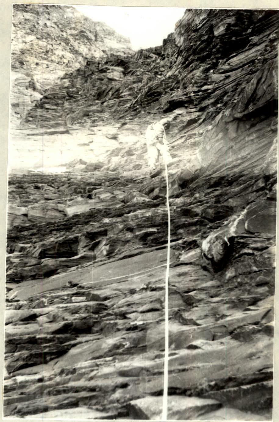
- R1–R2. Wall with a chimney. Slick rocks, covered with ice (see photo). Movement in crampons. Piton belay. Organization of belays.
- R2–R3. Rocky ridge. Rocks are destroyed, tile-like. Alternate movement with piton belay.
- R3–R4. Continuation of the rocky ridge. Rocks are more destroyed. Movement with alternate belay.
- R4–R5. Ice-firn slope.
- R5–R6. Steep rocky ridge. Alternate movement.
- R6–R7. Couloir with flow ice. Organization of belays. Movement in crampons.
- R7–R8. Rocky ledge with flow ice. Movement in crampons with alternate belay and organization of belays.
- R8–R9. Rocky ridge. Organization of belays.
- R11–R12. Rocky ridge. Organization of belays.
- R13–R14. Couloir, rocks covered with ice. Movement in crampons. Organization of belays.
- R14–R15. Wall. Icy rocks. Movement in crampons, organization of belays.
- R15–R16. Destroyed couloir. Rocks covered with ice. Movement in crampons, organization of belays.
Further movement to the summit is along snowy slopes and sharp snowy ridges with simultaneous and alternate belay.
 Route profile on the right. Shooting point #3.
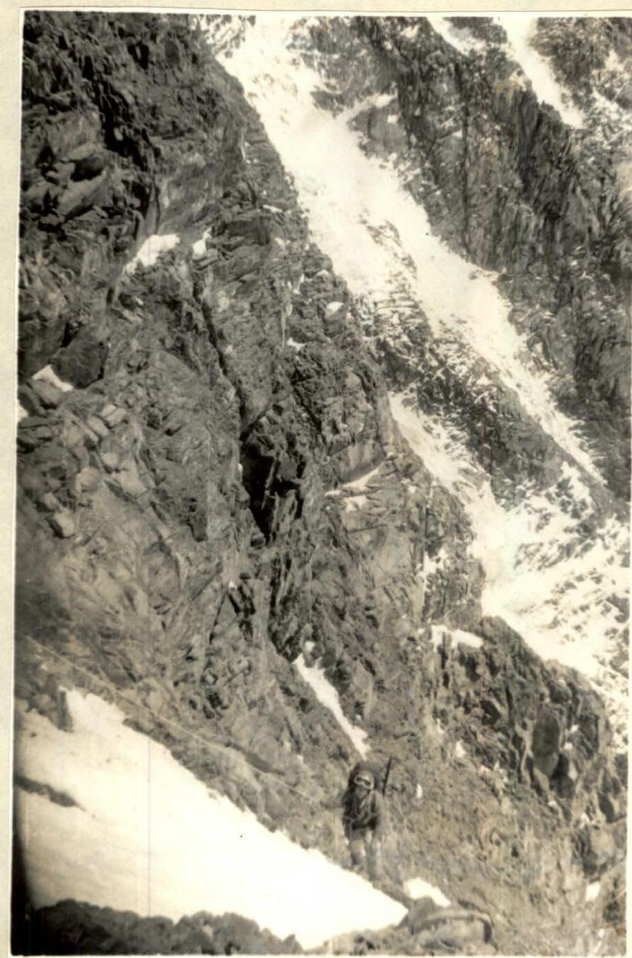 Section R8–R9
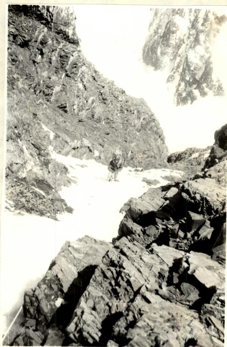 Section R13–R14