Central Pamir. Peak Kommunizma (7495 m), North-East Face
Team of the Central Council of the "Trud" Sports Society
Team Composition:
- Chunovkin G.A. MS — captain, coach
- Borzov Yu.V. MS — participant
- Slesov I.V. MS — participant
- Dzhioev G.L. MS — participant
- Mikhalev V.E. CMS — participant
1978
Brief Geographical and Sporting Characteristics of the Climbing Area
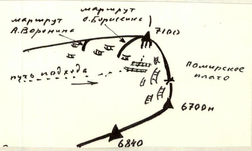
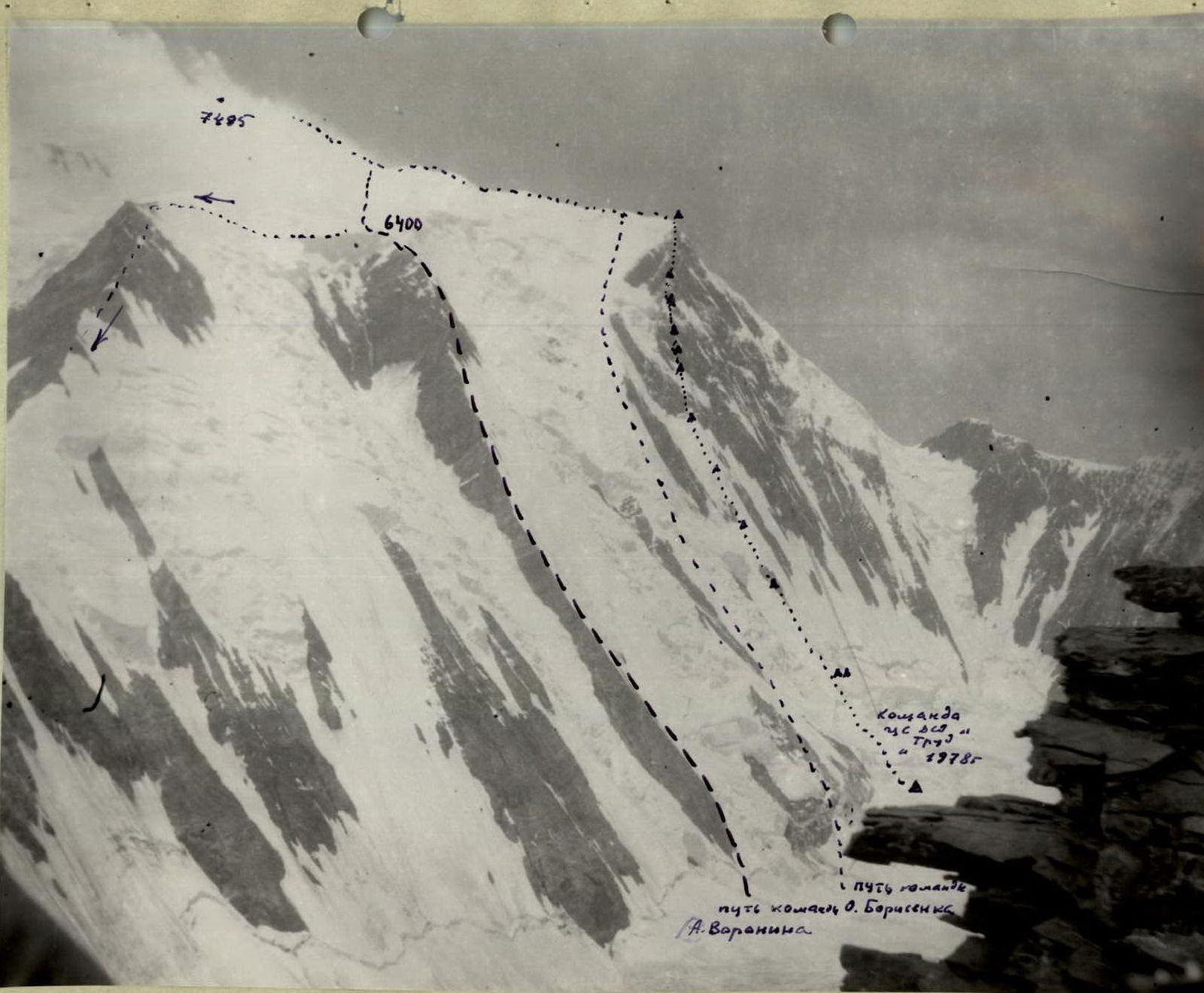
The north-eastern face of Peak Kommunizma is located in the upper reaches of the S. Ordzhonikidze Glacier. The relative inaccessibility of the upper reaches of the glacier has affected its frequency of visits by mountaineering expeditions. Despite the fact that the first ascent of Peak Kommunizma was made from this side (1933, E. Abalakov), the upper reaches of the S. Ordzhonikidze Glacier began to be explored only in the 1970s. In 1970, the eastern ridge was climbed, to the left of the north-eastern face of Peak Kommunizma (the upper part of the ridge joins the ascent route of E. Abalakov at a height of 6400–6500 m) by a team from Tashkent led by A. Voronin. In 1972, a group from Leningrad's "Spartak" under the leadership of O. Borisenko ascended via the left edge (ridge) of the north-eastern face.
In 1977, a team from Leningrad (led by G. Chunovkin) visited the upper reaches of the S. Ordzhonikidze Glacier and made a first ascent up the face to Peak Izvestiy (6840 m) as part of the USSR Championship.
This season, three applications were submitted to climb the north-eastern face in the high-altitude class of the USSR Championship, indicating the growing mountaineering "prestige" of the face.
Depending on the timing of arrival in the area and the completion of acclimatization, the "Mehnat" Sports Society team from Tashkent, led by A. Putiltsev, was the first to start the route, choosing an ascent on the right part of the face.
A few days later, the Central Council of the "Spartak" Sports Society team started, but due to an accident, the ascent was not completed.
Our team planned to start the route when A. Putiltsev's group finished climbing the face and reached the ridge, ensuring complete safety from falling rocks, which is particularly important in the upper part of the face.
The base camp of our team was located on the right side of the Bivachny Glacier at an altitude of 3900–4000 m, in a place where the team had previously camped in 1973, 1975, and 1977.
Given the team's familiarity with the area and the object of the ascent, it was decided not to conduct a reconnaissance sortie to the face but, while making an acclimatization ascent to Peak Ordzhonikidze (6300 m), to conduct a distant clarification of the route's condition. To facilitate the subsequent exit to the upper reaches of the S. Ordzhonikidze Glacier, a drop of equipment, supplies, and fuel was successfully made by helicopter at the start of the route.
Historically, the initial camp for all ascents in this area has been "Camp 4600" ("Abalakov's overnight stays"). Two acclimatization sorties were made to this camp, and supplies and equipment were dropped. This camp can be considered the base camp as it was well-equipped with everything necessary and housed observation groups from all expeditions.
Most of the information about the face's behavior and characteristics was obtained in 1977 during the ascent of Peak Izvestiy, when the team had the opportunity to observe continuously for a week. In 1978, the face was less snowy, requiring a more cautious approach to route selection and ascent tactics. Analysis of all information about the face's condition allowed for the development of a tactical ascent plan and the selection of a route to the left of the "Mehnat" team's path.
 The following circumstances supported this choice:
- Reduced steepness of the face in the left part of the route;
- Lower probability of avalanches on the chosen section;
- Presence of reliable belay points along the intended path;
- This is the safest ascent route, ensured by being a natural division between two large couloirs — paths for avalanches and falling rocks in the lower, icy part, and leading to the right part (edge) of a large cirque in the upper part, also reducing the likelihood of falling rocks;
- The route is combined, with about 2/3 being an ice wall and 1/3 rock, making it more interesting to climb;
- The novelty of the face, its significant extent, and harsh conditions also attracted our attention.
From the perspective of developing a tactical ascent plan, apart from the optimal route selection, the following circumstances were significant:
- Sun exposure on the face: until 15:00 on the icy part of the route, and until 14:00 on the upper, rocky part; cold was particularly troublesome after August 10 (weather change);
- Complete lack of convenient bivouac sites, which was considered in the following: choosing a team size of five, and abandoning a collective sleeping bag.
The difficulty in organizing bivouacs led to the team losing all ice axes by the end of the lower, icy part of the route, as they were broken while chopping out necessary platforms in the ice.
Analysis of weather conditions in 1973, 1975, and 1977 indicated that the weather in the area was good between August 3–20. Thus, the start of the route, considering the completion of acclimatization, was planned for August 3–6.
On August 3, the team left the base camp for "Camp 4600 m".
On August 4, they transitioned from "Campou 4600" to the start of the route by the S. Ordzhonikidze Glacier.
On August 5, a reconnaissance under the face was conducted, with some processing of the bergschrund in the lower part.
On August 6, the ascent began (see the table of main characteristics for details).
Some general points to note during the ascent:
- Movement was largely along the entire route via previously installed ropes by the "double" team;
- "Double" teams alternated in various combinations;
- At the end of each working day, several ropes were installed above the bivouac site, while the "triple" team prepared the platform;
- The team maintained a uniform work schedule;
- No stops were made during the working day to prepare meals — food was twice a day;
- The "triple" team released the rear ropes and handed them to the first "double" team during movement;
- All installed pitons were used for belaying.
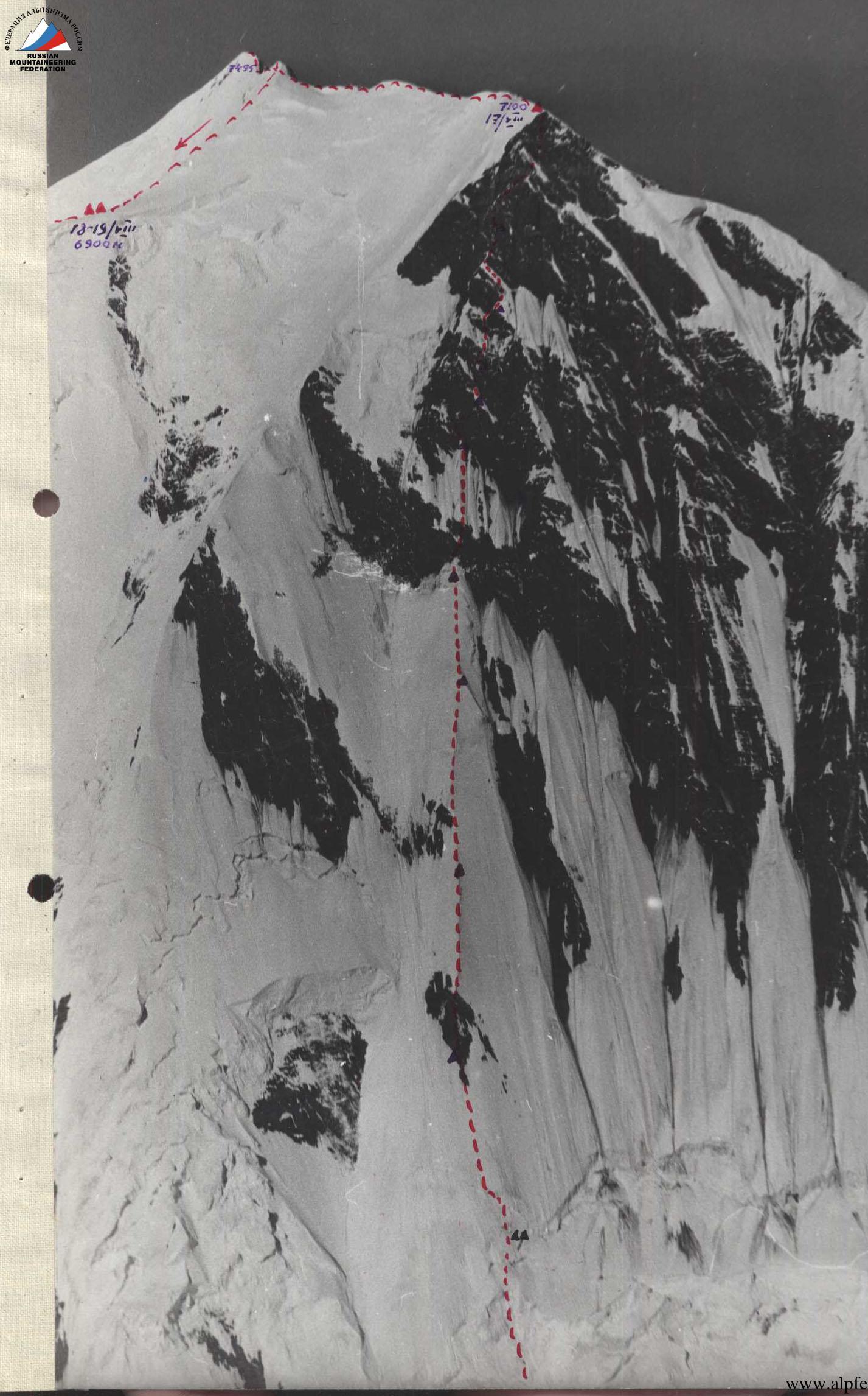
Sections R0–R12, the ice wall, which constitutes about 2/3 of the route, generally has a consistent steepness except for several ice pitches and a rock "island" in the middle part.
The rocky part of the route (sections R16–R42) is steeper, with heavily deteriorated rocks, requiring extreme caution. Strong rockfall was observed to the right and left of the route.
Mostly very poor overnight stays due to the face being smoothed by spring avalanches. Abundance of "live" rocks. Cold is particularly felt in the upper, rocky part. While the lower, icy part is a relatively straight ascent line, the upper, rocky part involves many sections of traversing rather than vertical ascent.
Although no rocks fell on the chosen route during the ascent, caution was maintained: the most dangerous time was between 8:00 and 13:00. Rockfall is possible at other times but less likely.
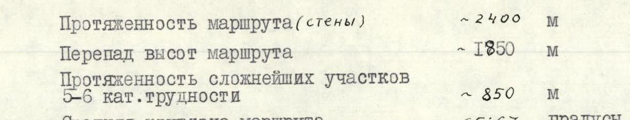
Table
of main characteristics of the ascent route to Peak Kommunizma (7495 m) via the north-eastern face
| Date | Section Designation | Average Steepness of Section (°) | Section Length (m) | Relief Character | Difficulty Category | Condition | Weather | Rock Pitons | Ice Pitons | Bolt Pitons |
|---|---|---|---|---|---|---|---|---|---|---|
| I | 2 | 3 | 4 | 5 | 6 | 7 | 8 | 9 | 10 | II |
| 6/VIII | R0–R1 | 50 | 100 | Ice wall | 5 | ice | good | — | 10 | Not used |
| R1–R2 | 80–85 | 20 | Ice pitch | 6 | Solid ice | — | — | 6 (m) | — | |
| R2–R3 | 50 | 100 | Ice wall | 5 | Ice | — | — | II | — | |
| R3–R4 | 80 | 10 | Ice pitch | 6 | Ice | Good | — | 4 | — | |
| R4–R5 | 55 | 90 | Ice wall | 5 | ice | — | — | 10 | — | |
| R5–R6 | 60 | 15 | Ice cornice | 5 | ice | — | — | 2 | — | |
| R6–R7 | 60 | 160 | Ice wall | 6 | ice | — | — | 18 | — | |
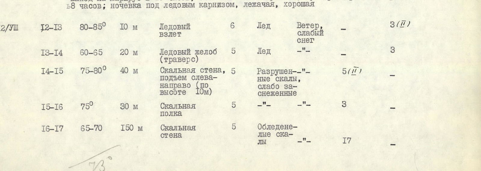
| 7 and 8/VIII | R7–R8 | 85 | 20 | Rock wall, start of "island" | 5 | Deteriorated rocks | — | 5 (I) | — | — |
| 9/VIII | R8–R9 | 60 | 140 | Rock wall | 5 | Deteriorated rocks | Good | 12 | — | — |
| R9–R10 | 60 | 440 | Ice "knife" — edge of two slopes | 6 | Hard ice | — | — | 41 (Σ) | — | |
| 10/VIII | R10–R11 | 80–85 | 60 | Ice pitch | 6 | Hard ice | good | — | 19 (于) | — |
| R11–R12 | 60 | 140 | Ice wall | 5 | Ice | — | — | 12 | — | |
| 12/VIII | R12–R13 | 80–85 | 10 | Ice pitch | 6 | Ice | Wind, light snow | — | 3 (ㅍ) | — |
| R13–R14 | 60–65 | 20 | Ice groove (traverse) | 5 | Ice | — | — | 3 | — | |
| R14–R15 | 75–80 | 40 | Rock wall, ascent from left to right | 5 | Deteriorated, lightly snow-covered rocks | — | 5 (I) | — | — | |
| R15–R16 | 75 | 30 | Rock shelf | 5 | — | — | 3 | — | — | |
| R16–R17 | 65–70 | 150 | Rock wall | 5 | Icy rocks | — | 17 | — | — | |
| 13/VIII | R17–R18 | 80–85 | 40 | Rock wall, ascent from right to left | 5 | Deteriorated rocks | good | 6 (I) | — | — |
| R18–R19 | 75–80 | 40 | Rock wall, ascent from left to right | 5 | — | — | 5 (I) | — | — | |
| R19–R20 | 70 | 80 | Rock wall | 5 | Rocks covered in ice | Light snow blown by wind from slopes | 3 (I) | — | — | |
| 14/VIII | R20–R21 | 60–65 | 60 | Rock wall, edge of large groove | 5 | Snow-covered rocks | Wind, snow | 7 | — | — |
| R21–R22 | 80–85 | 40 | Rock wall | 6 | Covered in ice | Wind, snow | 10 (V) | — | — | |
| R22–R23 | 70–75 | 40 | Internal corner | 5 | Snow-covered rocks | — | 5 (I) | — | — | |
| 15/VIII | R23–R24 | 85–90 | 15 | Rock wall | 6 | Monolithic rock | Wind, sun | 6 (III) | — | — |
| R24–R25 | 75–80 | 40 | Rock wall, ascent from left to right | 5 | Deteriorated rocks | — | 5 | — | — | |
| R25–R26 | 65–70 | 40 | Rock wall | 5 | Rocks covered in ice | — | 6 (III) | — | — | |
| R26–R27 | 75–80 | 40 | Internal corner | 5 | Monolithic rocks | — | 8 (III) | — | — | |
| R27–R28 | 65–70 | 30 | Oblique shelf (left to right) | 5 | Rocks with ice | — | 5 | — | — | |
| 16/VIII | R28–R29 | 60–65 | 25 | Rock wall | 5 | Covered in ice | Snow, wind | 4 | — | — |
| R29–R30 | 60 | 40 | Ice wall | 5 | Ice | — | — | 6 | — | |
| R30–R31 | 75 | 40 | Rock wall | 5 | Deteriorated rocks | — | 5 | — | — | |
| R31–R32 | 90 | 20 | Rock wall | 6 | Deteriorated, unstable rocks | — | 7 (V) | — | — | |
| R32–R33 | 80 | 20 | Rock shelf | 5 | Rocks deteriorated, unstable | Snow, wind | 3 | — | — | |
| 17/VIII | R33–R34 | 90 | 15 | Rocks | 6 | Solid rocks | Good | 5 (III) | — | — |
| R34–R35 | 70 | 50 | Rock wall | 5 | Deteriorated rocks | — | 5 | — | — | |
| R35–R36 | 80 | 15 | Shelf (traverse) | 5 | Monolithic rocks | — | 3 (I) | — | — | |
| R36–R37 | 90 | 15 | Wall | 6 | Huge "live" rocks | Wind, light snow | 5 (III) | — | — | |
| R37–R38 | 75 | 40 | Internal corner | 5 | Deteriorated rocks | Wind, cold, snow | 4 | — | — | |
| R38–R39 | 80 | 15 | Shelf (traverse right to left) | 5 | — | — | 2 (I) | — | — | |
| R39–R40 | 50 | 50 | Rocky slope | 3 | Individual, freely lying rocks | Strong wind, cold | 2 | — | — | |
| R40–R41 | 60 | 30 | Rock edge and traverse | 3 | Snow | Strong wind, cold | — | — | 1 | |
| R41–R42 | 60–65 | 15 | Snow pitch from rock edge to upper point of face on eastern ridge | 5 | Compact snow, belay through ice axe head | — | — | — | — | |
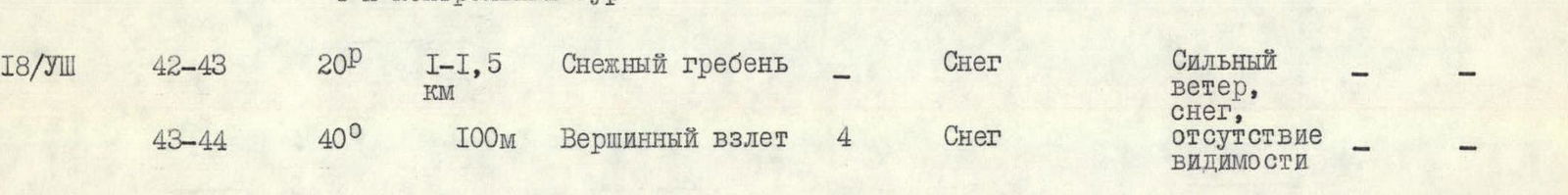
| 18/VIII | R42–R43 | 20 | 1.0–1.5 | Snow ridge | — | Snow | Strong wind, snow | — | — | — |
| R43–R44 | 40 | 100 | Summit pitch | — | Snow | Lack of visibility | — | — | — |
Started the route at 10:00, stopped for bivouac at 19:00; total walking hours — 9 h; overnight stay in the bergschrund — lying down.
Processing took 8 h on 7/VIII.
Started on 8/VIII at 12:00, stopped for bivouac at 19:00; total working time — 7 h; overnight stay sitting on a rocky shelf — 1st control tour.
In the middle part of section R9–R10, after climbing 240 meters, an overnight stay was made, chiseled out in the ice, semi-reclining; started the route at 11:00, stopped for bivouac at 20:00; total of 9 walking hours.
On August 10. At the end of section R9–R10, another overnight stay was made, chiseled out under the ice pitch (R10–R11), sitting; started the route at 10:00, stopped at 18:00; total walking hours — 8.
Started the route at 10:00, stopped for bivouac at 20:00, total working time 10 h; overnight stay on a rocky shelf, sitting, poor (apart 1 and 4 people), 2nd control tour.
Started the route at 11:00, stopped at 19:00, total working time 8 h; overnight stay on a rocky-ice shelf, semi-reclining.
Started the route at 10:00, stopped for bivouac at 20:00, total working time 10 h, overnight stay on a snow cornice, lying down, good.
Started the route at 10:00, stopped for bivouac at 19:00; total movement time 9 h. Overnight stay on a small rocky-ice ridge of a couloir, semi-reclining.
Started the route at 10:00, stopped for bivouac at 19:00; total movement time 9 h. Overnight stay on a small rocky shelf, sitting, extremely poor, 3rd control tour.

Started the route at 8:00, stopped for bivouac at 20:00; number of walking hours 12; overnight stay on the eastern ridge of Peak Kommunizma, excellent, lying down, 4th control tour.
Started the route at 12:00, reached the summit of Peak Kommunizma at 15:00; total working time to the summit 3 h. Overnight stay lying down on the descent, at an altitude of 6900 m on E. Abalakov's route.
During the descent from Peak Kommunizma, the weather further deteriorated. With great difficulty, at 18:00 on 18/VIII, we found "Camp 6900", where we had to spend two nights due to bad weather — complete lack of visibility. As the weather did not improve, on August 20, we decided to descend lower. Supplies and our strength were not replenished. We set out at 8:00 and, with all precautions, began to search for the descent path in complete lack of visibility, which we successfully managed to do. At a height of 6000–6200 m, gaps appeared in the clouds. At 19:00, we had a joyful reunion in "Camp 4600" on the glacier with the observation group.
The base camp welcomed us the next day, and a helicopter arrived immediately. The ascent was completed.
All participants of the ascent showed courage and endurance and, despite the duration of the ascent and its difficulties, preserved these qualities until its completion.
Particularly valuable was that the team, composed of athletes from different cities (Leningrad, Rostov), who were not previously closely acquainted, demonstrated the best moral and sporting qualities, which underscores the participants' significant mountaineering experience and good mountaineering upbringing.
The team's sporting preparation corresponded to the chosen ascent route.
Coach, team captain
G. Chunovkin
Support for the Ascent by Auxiliary Groups
Simultaneously with our team, the base camp was vacated by two other groups of the expedition, which were to undertake ascents on Peak Kommunizma via different routes, while maintaining constant radio contact with "Camp 4600" to receive information about the team's status on the north-eastern face.
The 1st group, led by A. Temirov, started on the A. Voronin route earlier than our team, on August 5.
The 2nd group, led by A. Kiselev, started on the E. Abalakov route after A. Temirov's group reached the summit pitch (August 9).
Thus, in the ascent area, qualified athletes of not less than the 1st sports category were available in constant readiness.
Recommendations for Subsequent Ascent on the North-East Face of Peak Kommunizma
- We believe that our route on the north-eastern face is the least prone to rockfall and can be recommended for future repetition. In confirmation, it can be noted that during the 12 days of ascent, not a single rock fell on the route, while strong rockfalls occurred to the right and left.
- The group should be small, with one tent, and an optimal size of 5 people.
- Caution should be exercised in the lower part of the face, in the area of both bergschrunds, due to possible rockfall that has changed its trajectory. Direct fall is practically excluded due to the protection of the rock "island". It is better to pass these areas after 14:00–15:00.
- For greater safety, it should be considered that in warm weather, rocks "move" from the upper part of the face, but the middle part is the most dangerous in this regard.
- It is advisable for the group to have 2–3 extra ropes to ensure the "double" team's work during bivouac organization.
- When developing a tactical plan, orient towards good overnight stay locations on the route, which will help preserve strength.
- It is necessary to have the required number of warm clothes, as it is very cold on the face in case of bad weather.
- The number of ice pitons should be at least 15–20 pcs, and rock pitons — 50–60 pcs.
Comparison of the Route with Others
Among routes similar to the north-eastern face of Peak Kommunizma, the following can be noted:
- In terms of the rocky part — the southern face of Peak Kommunizma (the team leader was there in 1970 up to a height of 6500 m), the north-eastern faces of Peak F. Engels (less deteriorated) and Peak Tajikistan;
- In terms of the icy part — there are no similarly long icy routes of high steepness in the team's history; this part can likely be compared to the icy part of the route on Peak Russia from the Belyaev Glacier.
Note
The total weight of food supplies was about 22 kg, calculated at 300–400 g per day for 15 days of travel. Meat and some other types of products were in freeze-dried form.
The amount of gasoline was 6.5 liters. The weight of the public load, not counting the weight of ropes, ice axes, crampons, boots, etc., was 8–9 kg per participant at the start of the route.
Before the ascent, it was planned that the route profile would be photographed during the descent. If you approach the edge of the drop-offs on the S. Ordzhonikidze Glacier from E. Abalakov's route at a height of 6800–6500 m, you can do this. The weather, however, did not allow the plan to be carried out.
The photo provided in the report (page 20) from the slopes of Peak S. Ordzhonikidze (5800 m) gives a somewhat distorted view of the steepness. It is impossible to photograph the route profile from the glacier due to the face's specific location, as can be illustrated by the diagram.
The diagram shows that the most accurate representation of the face's profile can be obtained from a height of 6400–6800 m, to the right of E. Abalakov's path.