Ascent Passport
- Ascent class: high-altitude.
- Ascent area: Central Pamir, Academy of Sciences range.
- Peak: Peak Kommunizma (7495 m) via the southwest ridge from Belyaev Glacier.
- Difficulty category: 6B.
- Route characteristics:
- elevation gain 2800 m
- length of sections R0–R1 diff. cat. — 430 m.
- average steepness of the ridge — 50°.
- Pitons driven:
for belaying: for creating anchor points:
- rock 96 1
- ice 48 1
- chocks 29 -
- Total climbing hours — 29.
- Number of bivouacs and their characteristics: total of three bivouacs, including:
- one semi-reclined on ice;
- one semi-reclined on rocks;
- one on snow.
- Team composition: Palamarchuk Valery Nikolayevich, USSR Master of Sports — team leader Trasevich Alexey Ivanovich, USSR Master of Sports Gorbenko Mstislav Mstislavovich, USSR Master of Sports Kulichenko Anatoly Petrovich, Candidate Master of Sports Mazarchuk Mikhail Alexandrovich, Candidate Master of Sports Likhachev Valery Grigoryevich, Candidate Master of Sports Kholoptsev Alexander Vadimovich, Candidate Master of Sports Yatsko Vsevolod Sergeyevich, Candidate Master of Sports
- Team coach: Honored Coach of the USSR, USSR Master of Sports G. V. Polevoy.
- Departure date 2 August 1981. Return date 7 August 1981.
Organizational and Tactical Ascent Plans
The organizational plan was fully implemented with virtually no deviations. In January 1981, a training ski camp was held in the Carpathians. In May, all expedition members traveled to Crimea for rock climbing. Regular training sessions on cross-country skis were organized during the winter, as well as general physical training sessions at the stadium. Much attention was given to equipment preparation.
In June 1981, a recovery camp was held in Kiev, where the team prepared for the USSR Alpine Championship by completing control standards. The protocol for completing these control standards is attached.
The Ukrainian SSR Sports Committee team arrived in Dzhirgatal on 3 July 1981. With the help of a helicopter, the following were organized:
- a base camp at Surkova clearing;
- an intermediate camp at Grusinskye bivouacs.
Goods were also dropped onto the upper plateau of Belyaev Glacier below the South Face of Peak Kommunizma.
The acclimatization cycle structure before departing for the route was as follows:
- The entire team ascended the southwest slopes of Peak Pravda to an altitude of 5300 m, followed by a descent to Surkov clearing (10–12 July).
- A training ascent of Peak Pravda (6300 m) via the western ridge from Belyaev Glacier for the entire team, followed by a descent to Surkov clearing (14–15 July).
As a result of this plan, the team was ready to depart for the route by 20–22 July. However, prolonged bad weather from 16 July to 1 August forced the team to postpone their departure. An attempt to start the ascent on 26 July 1981 was unsuccessful due to constant rockfall and avalanches in the central couloir of the South Face.
Due to the expedition's time constraints and a long-term poor weather forecast, the coaching staff decided to direct the team to ascend via a safer route — the southwest ridge from Belyaev Glacier.
During the ascent, a tactic was employed that involved moving along the route without prior processing, as the high individual fitness of the participants and the team's cohesion allowed them to overcome the most challenging sections directly.
According to the tactical plan developed before the ascent:
- The team planned to reach the summit on the 4th day.
- Two days were allocated for the descent.
- An additional day was reserved for bad weather.
Considering the unfavorable weather conditions before departing for the route, which suggested the need for either waiting or reducing the pace, food was packed at a rate of 500 g per person per day, totaling 20 kg. Along with personal gear, the backpack weight reached 13–14 kg.
To ensure reliable communication with the base camp, an observation group was established.
Bivouac at 6950 m

 2 August 1981. Departure at 8:00
| Section designation | Average steepness | Length, m | Terrain characteristics | Difficulty | Route condition | Weather conditions | Pitons driven: Rock, pcs. | Ice, pcs. | Chocks, pcs. |
|---|---|---|---|---|---|---|---|---|---|
| R0–R1 | 35° | 200 | Wide snow couloir | 2 | Dense firn | Clear. Frost | Belay through ice axe | - | - |
| R1–R2 | 60° | 120 | Rocky ridge | 4 | Snow-covered rocks | « | 8 | - | 2 |
| R2–R3 | 75° | 30 | Slab | 5 | Flowstone | « | 6 | 2 | - |
| R3–R4 | 95° | 10 | Internal corner | 6 | « | « | 2 | - | 4 |
| R4–R5 | 80° | 60 | « | 5 | Snow-covered rocks | « | 6 | - | 2 |
| R5–R6 | 50° | 200 | Rocky ridge | 3 | « | « | - | - | 4 |
| R6–R7 | 40° | 200 | Snow slope | 3 | Loose snow | Clear. Hot | Belay through ice axe | - | - |
| R7–R8 | 30° | 120 | Rock-snow ridge | 4 | Snow-covered broken slabs | « | 4 | 2 | - |
| R8–R9 | 45° | 120 | Snow-covered slabs | 4 | « | « | 6 | 4 | - |
| R9–R10 | 45° | 120 | Ice slope | 4 | Loose ice | Clear. Hot | - | 8 | - |
| R10–R11 | 80° | 10 | Ice wall | 6 | Smooth ice | « | - | 4+1 | - |
| R11–R12 | 40° | 80 | Snow slope | 3 | Loose snow | « | Belay through ice axe | - | - |
Bivouac stop at 16:30. Climbing hours 8 h 30 min.
3 August 1981. Departure from bivouac at 8:00
| Section designation | Average steepness | Length, m | Terrain characteristics | Difficulty | Route condition | Weather conditions | Pitons driven: Rock, pcs. | Ice, pcs. | Chocks, pcs. |
|---|---|---|---|---|---|---|---|---|---|
| R12–R13 | 45° | 120 | Snow slope | 4 | Firn | Clear, frost | Belay through ice axe | - | - |
| R13–R14 | 70° | 20 | Ice ledge | 4 | Hard ice | « | - | 4 | - |
| R14–R15 | 45° | 80 | Snow slope | 3 | Dense snow | « | Belay through ice axe | - | - |
| R15–R16 | 70° | 60 | Ice crevasse | 5 | Ice | « | - | 10 | - |
| R16–R17 | 40° | 100 | Snow slope | 4 | Loose snow | Clear, warm | Belay through ice axe | - | - |
| R17–R18 | 45° | 100 | « | 4 | Loose deep snow | Clear, hot | « | - | - |
| R18–R19 | 45° | 100 | Ice slope | 4 | Porous ice | « | - | 4 | - |
| R19–R20 | 45° | 40 | « | 4 | Ice | Clear, wind | - | 2 | - |
| R20–R21 | 45° | 120 | Rock-ice slope | 4 | « | Clear, strong wind | 8 | 4 | - |
| R21–R22 | 60° | 120 | Rocky ridge | 5 | Snow-covered rocks | Hurricane-force wind | 6 | 1 | 1 |
Bivouac stop at 16:00. Climbing hours 8 h.
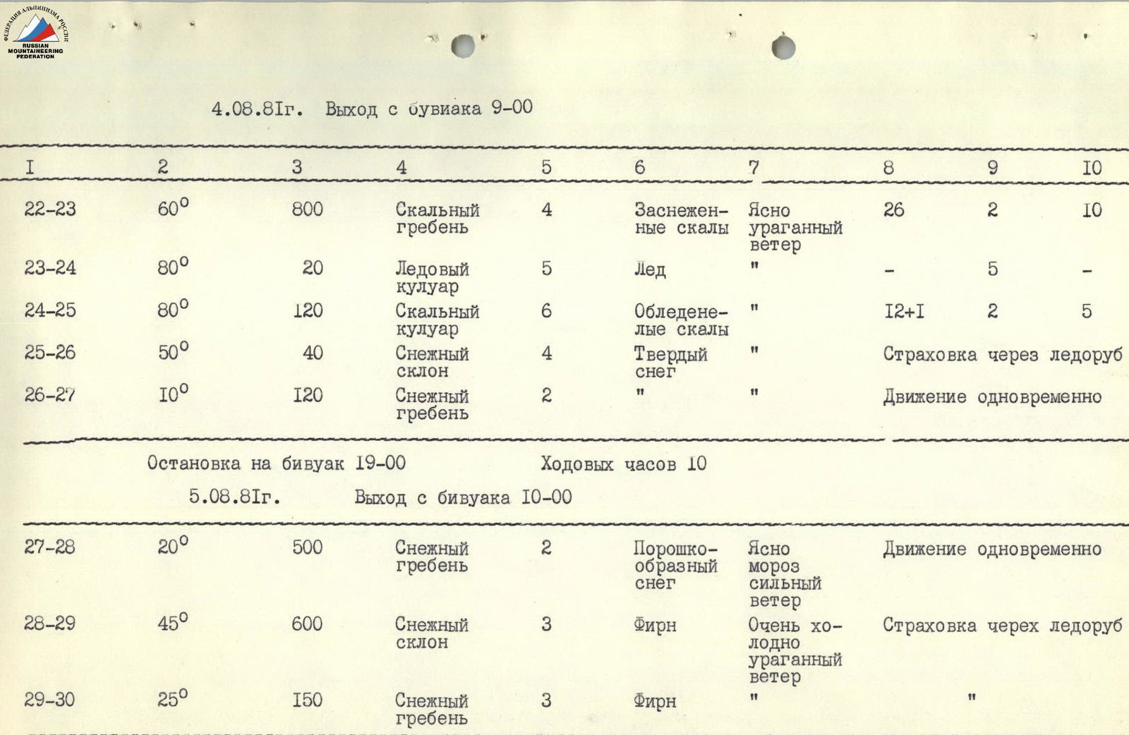
4 August 1981. Departure from bivouac at 9:00
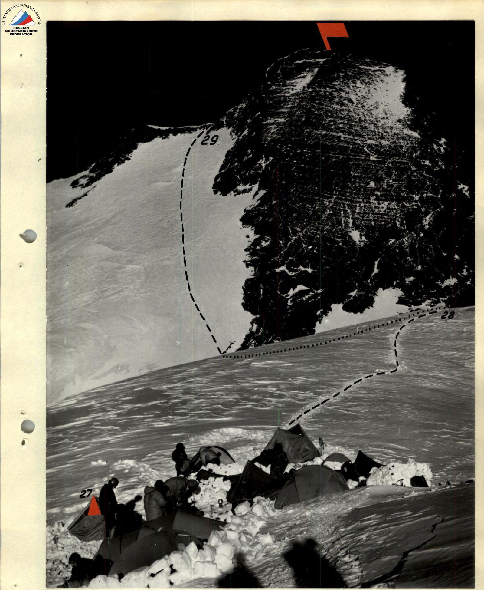
| Section designation | Average steepness | Length, m | Terrain characteristics | Difficulty | Route condition | Weather conditions | Pitons driven: Rock, pcs. | Ice, pcs. | Chocks, pcs. | | :------------------: | : | :--------------: | :---------------: | :----------------: | :-------: | :----------------: | :--------------------: | :---------------------------: | :-----: | :-----------: | | R22–R23 | 60° | 800 | Rocky ridge | 4 | Snow-covered rocks | Clear, hurricane-force wind | 26 | 2 | 10 | | R23–R24 | 80° | 20 | Ice couloir | 5 | Ice | « | - | 5 | - | | R24–R25 | 80° | 120 | Rocky couloir | 6 | Icy rocks | « | 12+1 | 2 | 5 | | R25–R26 | 50° | 40 | Snow slope | 4 | Hard snow | « | Belay through ice axe | - | - | | R26–R27 | 10° | 120 | Snow ridge | 2 | « | « | Simultaneous movement | - | - |
Bivouac stop at 19:00. Climbing hours 10 h.
5 August 1981. Departure from bivouac at 10:00
| Section designation | Average steepness | Length, m | Terrain characteristics | Difficulty | Route condition | Weather conditions | Pitons driven: Rock, pcs. | Ice, pcs. | Chocks, pcs. |
|---|---|---|---|---|---|---|---|---|---|
| R27–R28 | 20° | 500 | Snow ridge | 2 | Powdery snow | Clear, frost, strong wind | Simultaneous movement | - | - |
| R28–R29 | 45° | 600 | Snow slope | 3 | Firn | Very cold, hurricane-force wind | Belay through ice axe | - | - |
| R29–R30 | 25° | 150 | Snow ridge | 3 | Firn | « | « | - | - |
Reached the summit at 15:00. Climbing hours 5 h.
Descent via Nekrasov's route. Route length — 4580 m. Elevation gain — 2800 m. Climbing hours — 31 h 30 min. Pitons driven:
- rock — 96 + 1
- ice — 48 + 1
- chocks — 29
- anchor points — 2
Brief Explanation of the Table
2 August 1981. Team departure at 6:30 from Grusinskye bivouacs. At 8:00, we approach the route. The route begins with a wide snow couloir leading to a rocky ridge in its lower third, before a clearly visible ascent (R0–R1). The ascent is made directly (R1–R2). Rocks are snow-covered and heavily destroyed. From the top of the ascent, along a narrow isthmus to an overhanging rocky wall. Under the wall, a traverse (R2–R3) along difficult, flowstone-covered rocks to an overhanging internal corner (R3–R4). Through the overhanging rocks of the internal corner, we exit into its less steep part, leading (R4–R5) to a rocky-snow ridge (R5–R6). Along the ridge to its end. From here, an 8 m rappel onto a steep snow slope. Up the slope directly (R6–R7) to its transition into a rocky-snow ridge. The sun has come out, softening the snow on the slope. We move waist-deep in snow. From the slope, we move to a rocky-snow ridge (R7–R8), resting against a rocky-ice slope ending in a powerful ice ledge. Up the slope (R8–R9), ascent to the ice wall of the ledge. The wall is bypassed on the left along a steep ice slope (R9–R10). The slope leads to a steep 80° wall (R10–R11), which we ascend. The top of the ledge is covered in snow, along which (R11–R12) we move directly towards a characteristic serac "Triangle". Below it, we bivouac on ice platforms. From Grusinskye bivouacs to the bivouac in the icefall, the group ascended in 8 hours. Altitude 5800 m. The bivouac is safe and well-protected from the weather. On the ice platforms, we set up two tents in tandem. The bivouac is semi-reclined. 3 August 1981. Departure from the icefall bivouac at 8:00. The path goes up to the right along a steep snow slope towards the lowest point in the powerful ice ledges barrier (R12–R13). Up the steep ice, ascent onto a serac (R13–R14). From it, further up to the right along a snow slope (under the snow, crevasses!) (R14–R15) towards an ice crevasse cutting through the next ice ledges barrier. Ascent to the crevasse (R15–R16) up to the right along a steep ice wall. Then along the crevasse floor to the plug and from it, exit up to the right along the steep wall of the crevasse onto a snow slope with gaps, which is the top of the ice ledge. The sun has made the snow loose, we move sinking waist-deep (R16–R17). The path along the slope is physically very difficult due to deep snow and dangerous due to giant ice gaps barely covered by snow. From the snow overhang along a steep ice slope towards a black stone (R19–R20). The steepness of the ice slope is 45°–50°. On top of the ice is a thin layer of snow, making movement difficult. From the black stone up to the left along the ice 40 m to snow-covered slabs, which lead to a snow isthmus. The slabs are heavily destroyed, covered in snow, making movement difficult and requiring careful belaying (R20–R21). From the isthmus, along the ridge to the left, movement directly up 120 m. Very strong wind. Cold. At the end of this section, there is a shelf where a semi-reclined bivouac was set up. Time 16:00 (R21–R22). Altitude 6300 m. The entire night, hurricane-force winds blow. Several times during the night, we had to stretch the tent. 4 August 1981. Departure at 9:00. From the bivouac directly up, movement along a rocky, heavily snow-covered ridge with a steepness of 60° (R22–R23). The ridge is not very complex, but movement is greatly hindered by hurricane-force winds. At the top, the ridge rests against a rocky wall. The ascent passes in the left part of the wall along a very steep, ice-filled couloir 90° (R23–R24), transitioning at the top into a chimney with overhanging cornices (R24–R25). Climbing is very complex. Chocks are used effectively. At the top, the chimney leads to a snow slope, transitioning into a ridge, which leads to the western snow ridge of Peak Kommunizma (R25–R26). Along a simple, wide ridge, movement to the right 120 meters to a snow mulde. At 19:00, we stop for the night. Altitude 6950 m (R26–R27). 5 August 1981. Departure at 10:00 along a snow ridge (R27–R28) for 500 meters. A strong wind blows. Very cold. The ridge rests against a rocky wall, which we bypass on the left. Further along the slope with an average steepness of 600 meters, we reach the North Ridge (R28–R29). Along the ridge to the right and up, after 150 m, we reach the summit (R29–R30). On the summit at 15:00. Descent from the summit via route 5B diff. cat. (Nekrasov's route) through Pravda Plateau onto Belyaev Glacier.