41. Kommunizma. P. Budanov, 68.
4.1.40. Brief geographical description. Sporting characteristics of the ascent object and route conditions
The highest point in the USSR - Peak Kommunizma -32,7495 m, is located in the Academy of Sciences Range in the Central Pamir. This area is quite frequently visited by mountaineering expeditions and is fairly well studied both geographically and in terms of mountaineering. The rocky formations in this area are quite brittle and fragile, posing an objective danger when overcome. A large amount of precipitation falls in the area of the Academy of Sciences Range, and the weather is quite unstable with strong winds.
After the first ascent by E.M. Abalakova in 1933 via the W ridge, a large number of ascents to Peak Kommunizma have been made from various sides, and this year saw the largest number of climbers. A total of 62 people reached the summit, including the first woman.
2. Reconnaissance
July 17-21, a group consisting of Kletsko K.B., Agranovskii G.L., and Kletsko B.B. went to the area of height 4600 m (the location of the previous expedition's assault camp at the junction of the Kommunizma and Ordzhonikidze glaciers) to receive cargo dropped by helicopter and to visually observe the state of the route.
July 29 - August 5. A group consisting of Kletsko K.B., Kletsko B.B., Konoplev K.A., and Ustinov Yu.K. conducted a visual reconnaissance of the ascent object in the area of height 4600 m (assault camp). They climbed to the "shirma" to conduct film and photo shooting and also ascended to a height of 5600 m on the eastern ridge via the route taken by E.M. Abalakova, as the lower part of the W ridge is directly opposite the W Counterfort, allowing for careful and detailed observation over three days of the large icefall that poses an objective danger when approaching the W Counterfort. A path for traversing the counterfort was identified, and a specific ascent plan was drawn up.
July 27 - August 3, a group consisting of Budanov P.P., Agranovskii G.L., Ilyinskii G.Ya., and Kolchin A. went to the area of the 6200 m plateau via the Tam route to conduct a cache at a height of 6700-6900 m.
3. Ascent Plan
August 12, 1968: Base camp (3900 m) - assault camp (4600 m) August 13, 1968: Assault camp - upper part of the 1st rock bastion. August 14, 1968: Upper part of the 1st bastion - upper part of the 2nd rock bastion. August 15, 1968: Upper part of the 2nd bastion - 1st snow knife. August 16, 1968: 1st snow knife - large chimney filled with snow. August 17, 1968: Chimney - upper part of the 3rd rock bastion. August 18, 1968: Upper part of the 3rd bastion - ice hollow behind the rocks - 6700 m. August 19, 1969: Hollow - ridge saddle - 7000 m. August 20, 1968: Saddle - summit - saddle. August 21, 1968: Saddle - 6200 m plateau. August 22, 1968: Plateau - Rossiya glacier - 5300 m. August 23, 1968: Rossiya glacier - base camp. August 24-26, 1968: Reserve for weather conditions.
The ascent plan largely proved successful, except for the departure day, as the group that conducted the cache to a height of 6900 m needed an extra day of rest. During the descent from 6900 m to the 6200 m plateau on August 22, there was fog and strong wind with snow. To ensure safety, a bivouac was set up in the middle part of the slope (6500 m).
As a tactical variation of the route, starting from the bivouac at 5300 m (R5), the group processed the further ascent route every evening.
Domestically produced rock and ice pitons made of titanium were used on the route. Elongated channel pitons and expansion pitons made of titanium provided substantial assistance in navigating the route.
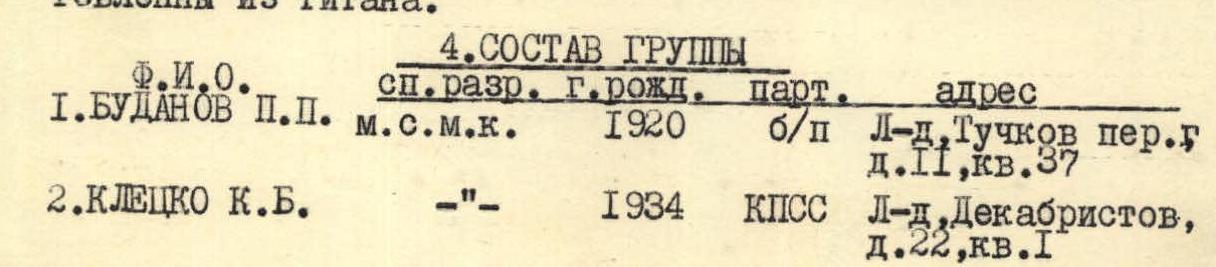
| № | Name | Sport rank | Year of birth | Party affiliation | Address |
|---|---|---|---|---|---|
| 1. | BUDANOV P.P. | MSMK | 1920 | b/p | Leningrad, Tuchkov per., d.11, kv.37 |
| 2. | KLETSKO K.B. | «-» | 1934 | CPSU | Leningrad, Dekabristov, d.22, kv.1 |
| 3. | AGRANOVSKII G.L. | MSMK | 1931 | b/p | Leningrad, Babushkina, 81, kv.87 |
| 4. | KLETSKO B.B. | MS | 1937 | CPSU | Leningrad, Drezdenovskaya, 12, kv.3 |
| 5. | KONOPLEV K.A. | «-» | 1930 | b/p | Gatchina, Gagarina, 11, kv.2 |
| 6. | ILYINSKII G.Ya. | PMS | 1931 | «» | Leningrad, L. Chaikinskoy, d.17, kv.20 |
| 7. | USTINOV Yu.K. | MS | 1936 | «» | Leningrad, Shaterlena, 2, korp.1, kv.39 |
| 8. | KOLCHIN A.A. | MS | 1932 | «» | Leningrad, B. Prospekt, d.7, kv.1 |
The declared group composition remained unchanged, and the ascent was completed in full.
5. Route Description
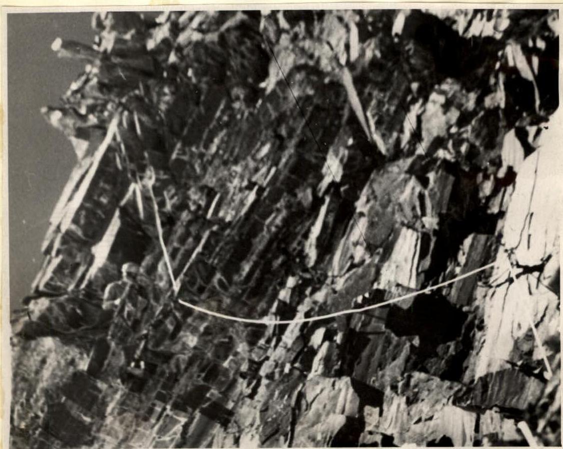
August 14, 1968. The beginning of the route (R0-R1) passes along a snow-ice slope broken by numerous crevasses; it is necessary to stick to the right side (in the direction of travel). Crossing the bergschrund and exiting onto the rocks of the counterfort must be done in the early morning hours. The path along the rocks goes (R1-R2) along the left side (in the direction of travel) near a long rock crack, which is excellently used for hammering in pitons. The length of the crack is about 60 m. The rocks are very brittle and steep; handholds and ledges can only be loaded vertically downward, as fragments of rock break off otherwise. Ice pitons and channel pitons are used. The crack ends in a snow shelf, from which a vertical rock gap (R2-R3) ascends, 5-7 cm wide and one rope length long. In the middle part, there is a wedged stone - it is bypassed on the left (in the direction of travel) with an exit to a small snow ledge, and then continues straight up again in a gap. At the end of the gap, it is necessary to go left and up along a smooth, nearly vertical slab, where 3 expansion pitons are hammered in and 4 step ladders are hung (R3-R4). In the middle part of the wall, it is necessary to take in the next climber, as the further path goes in a zigzag, and the rope will be difficult to pull through. There is a narrow snow-covered ledge. Backpacks are pulled up on this section. The wall leads to a shelf strewn with loose stones, and it is dangerous to move further until everyone has gathered together (R4-R5).
The shelf is not pleasant, as protruding rocks are thrown off at the end, and handrails are necessary. From the end of the shelf, a fairly steep rock ridge (R5-R6) ascends, leading to the upper part of the 1st rock bastion. It took a long time to choose a campsite, as there was nowhere to set up a tent. The night was spent semi-sitting. The section is very unpleasant, as the rocks are steep and do not hold; there is not even a place to grab with one's hand. Two long ladders - 10 m and 15 m - were hung.

August 15, 1968. We departed early, as there was not much sleep. Straight up, a rock ridge (R6-R7) ascends, gradually gaining steepness. The rock is somewhat stronger, but there are many loose stones. It is cold in the morning, and we move slowly. The ridge ends in a wall, which is passed straight up (R7-R8). There are small but strong handholds. The first climber goes without a backpack, as the climbing is complex. The first and second pairs pull up their backpacks, while subsequent climbers ascend on "abalaqs". Further to the left, a steep but wide shelf extends (R8-R9). The strongly cracked slab-like rocks are traversed. At the end of the shelf, under an internal angle, there is a place to set up a bivouac. The internal angle (R9-R10) is traversed along the right wall (in the direction of travel), and it is more convenient to hammer in pitons on the left; there are good cracks. Backpacks are pulled up. This work takes a lot of time. The internal angle turns into a rock gully, which goes up to the right (R10-R11). It is traversed on the right side (in the direction of travel). Inside the gully, there are wide cracks. Channel pitons are used. The middle part of the gully has a small platform where the next bivouac was set up. The night was again semi-sitting, but more comfortable than the previous one.
Slab-like rocks. (R8-R9) August 16, 1968. We departed early again for the same reasons.
The gully continues (R11-R12) but becomes steeper. There are few cracks, and it is necessary to search for places to hammer in pitons. The rocks are more smoothed out.
To the left and up, a rock wall with three small niches interrupts the gully (R12-R13):
- The exit to the third niche is very complex.
- The first climber ascended with the help of a товарищ's back.
- Backpacks are pulled up.
From the niche, a rock wall with a crack in the form of a small "otshchepina" (R13-R14) ascends:
- It seemed simple from below, but in reality, two expansion pitons and ladders were needed.
- Backpacks were again pulled up by hand.
Finally, the 2nd rock bastion was passed.
Further, a rock-snow ridge (R14-R15) follows:
- Not very difficult.
- The snow is loose.
- It is unpleasant to walk between rock blocks over a void.
The ridge is continued by an ice knife (R15-R16):
- For a change, this is even interesting, as we finally encountered ice.
- We chop steps and with pleasure hammer in ice pitons.
It is already evening, and a place to set up tents is not visible. Ahead, a rock ridge goes to the left (R16-R17):
- Not complex, but sharp.
- Passing it with large and heavy backpacks is difficult.
Finally, a place is found where platforms for a bivouac can be made. We stopped and began to work. The platforms turned out to be narrow, but it is more comfortable to sleep lying down.
Rock-snow ridge. (R14-R15) August 17, 1968. We departed early in the morning.
The snow-ice knife (R17-R18) was passed fairly quickly, but we got stuck on the wall. It is traversed along a protruding rock angle, but along its wall (right) (R18-R19). In the upper part, two huge boulders overhang; they are bypassed to the left and up on ladders. Backpacks were pulled up along the left part of the angle.
The further path again goes along a snow-ice knife (R19-R20) of approximately the same profile as the previous one. Step chopping and ice pitons are used.
The knife leads to another rock wall (R20-R21), which has a small "otshchepina" on the right side, along which the path goes. On the upper part of the rock, the rocks became stronger. There are fewer handholds, but if there are any, they can be safely grasped - they will not come off.
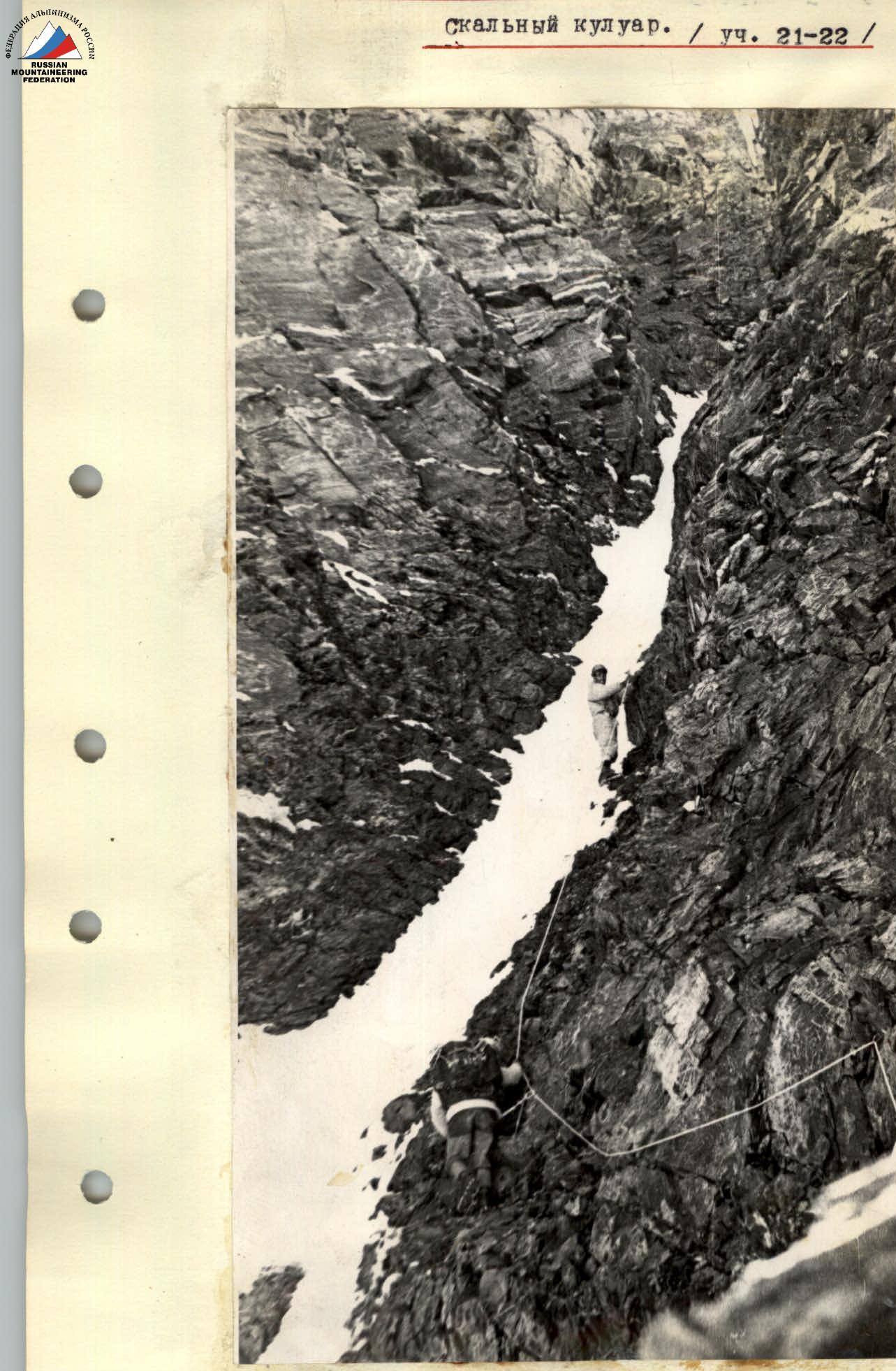
The "otshchepina" leads to a narrow rock couloir. Inside, the rocks have a tile-like structure, covered in some places with rimaye ice. It is difficult to find handholds, and even more so to hammer in a piton (R21-R22). At the beginning, a traverse to the left is made, and then straight up. For ease of passage in the upper part, as it is difficult to climb with a backpack, the backpack is attached to a separate rope, but not removed from the shoulders, and the upper climber "helps the backpack to be lighter"; the climber ascending feels more confident on the icy tile.
The right part of the couloir ends in a rock ledge, and further up, a steep rock ascent rises, requiring a lot of time to pass.
On the rock ledge, we set up (built from stones) places for two tents and established a bivouac. August 18, 1968.
To the right and up along a snow-covered shelf (R22-R23), the path goes to slabs that ascend to the left and up. The slabs are steep and heavily snowed (R23-R24).
On the counterfort, it is characteristic that the walls and slopes going down to the right (in the direction of travel) are all filled and covered with snow, while those going down to the left are often covered with rimaye ice and have huge icicles hanging.
The slabs lead to a rock gully, along which it is necessary to pass to the right and up to a diagonal crack. The path goes along the left side (in the direction of travel) (R24-R25) and only opposite the crack - a transition to the right under the crack. The left side is heavily iced.
The crack is almost vertical (R25-R26). In some places, only the palm of the hand can fit, which is essential, as the handholds are small.
Backpacks are pulled up and cursed for their weight. The pulling up is complex, as the entire system is quite diagonal, and the belay does not help, but rather hinders.
The crack ends in a shelf covered with snow. On the shelf (R26-R27), it is very uncomfortable: wide but steep. The snow does not hold. Under the snow, there is an icy slab. We stretched out handrails.
Further up, the 3rd rock bastion ascends. This is the only place on the route that remained a serious mystery for us, as during reconnaissance and visual observation - opinions on the options for its passage diverged.
The following options were proposed:
- Move slightly to the left and then go up through a chimney on the bastion;
- Bypass on the right in the direction of travel.
"R. Illeško accepts the next backpack for attachment"
Monolithic rock blocks rise steeply upward. The 1st rock wall is very complex (R27-R28). To begin the ascent along the wall, it is necessary to descend from the snow shelf to the right and down by 5 m and ascend to the right and up by 3 m to a rock ledge.
From this place, two cracks ascend. They are not visible from the snow shelf, as the ascent path goes as if in a large internal angle.
At the beginning, it is necessary to stick to the left crack (in the direction of travel) to a tiny platform (two footprints), after which a traverse to the right is made to the area of the right crack on ladders, using expansion pitons. Backpacks were pulled up fairly easily, as the wall is steep and smooth.
The platform to which the backpacks were pulled up is very small and is located 5 m to the left of the ascent path.
The 2nd rock wall (R28-R29):
- is less steep,
- but is impassable with a backpack, as it is first necessary to climb between the next block and the wall, and only then can one move upward,
- the path goes slightly to the right and leads to heavily snowed rocks.
There is already a lot of time spent, and it is time to stop for a bivouac, but there are no platforms for overnight stay. Semi-sitting at a height of 6300 m is fraught with undesirable consequences, and we (R29-R30), having stretched out handrails along the snow-covered rocks, move further upward in the hope of finding something suitable for overnight stay.
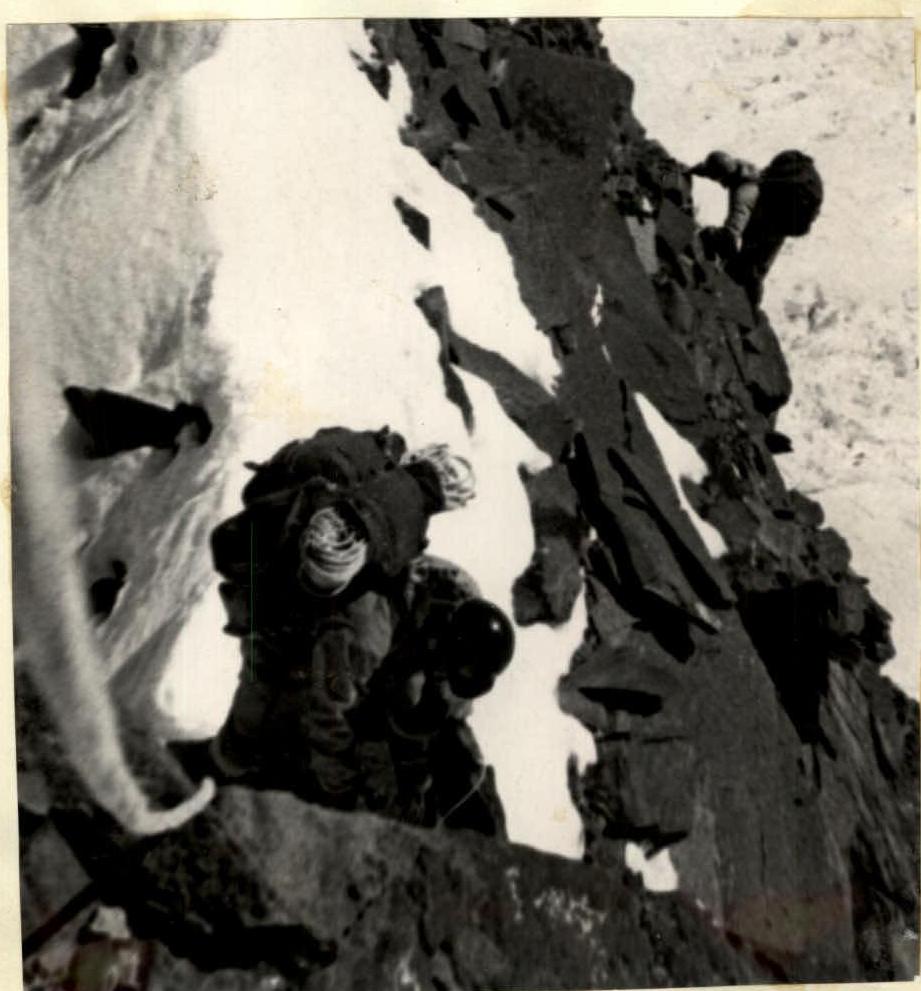
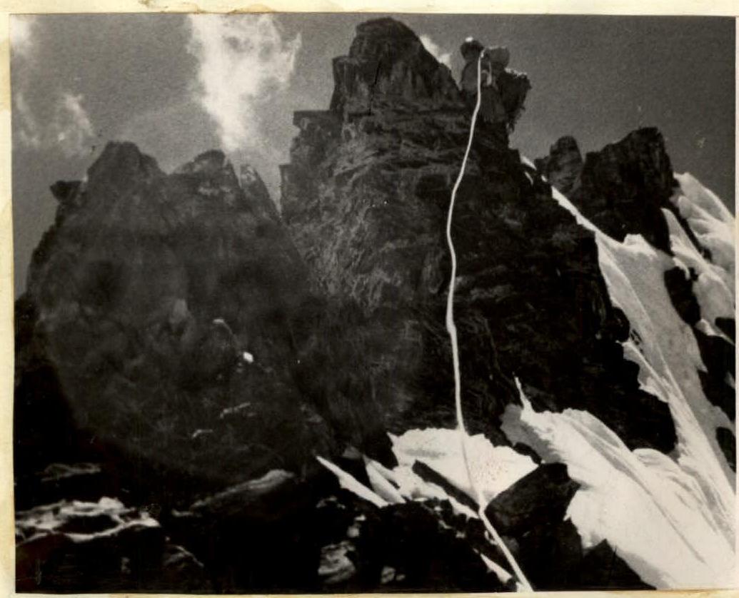
Ahead, a new obstacle - a rock tower. Here, we worked for a very long time (R30-R31). The path goes straight up to the right of a chimney completely filled with ice and snow. We hung two long ladders, 10 m each, and two short ones - 4-step. We did not remove the backpacks from our shoulders but helped by attaching them to a separate rope. The method for vertical sections proved itself fully. We almost reached the ice knife in the dark, chopped off the upper sharp part, barely managed to set up tents, and already in complete darkness (21:30) climbed into them.
The mystery was resolved, but many difficulties still lay ahead.

Snow-covered shelf. (R22-R23) August 19, 1968. The rock-snow-ice knife (R31-R32) is very labor-intensive to pass with heavy backpacks, as balancing at height is not a simple task.
The path goes along its upper part with three transitions across rock outcrops, which are used as belay points.
The knife leads to one of the last rock walls (R32-R33). It is steep, but there are many handholds. It is traversed straight up.
Assistance in pulling up backpacks is provided by the tried-and-true method of attachment.
The structure of the rocks, as at the beginning of the route, again turned out to be quite brittle.
The wall led to an ice slope going up to the left. The slope (R33-R34) is traversed on crampons. There are rock outcrops where belay points are set up.
Having passed a small ridge, the path goes up to the right to the beginning of the ridge, first along a snow-ice slope (R34-R35), and then exits onto snow-covered rocks. It is difficult to find places to hammer in pitons; steps are used more often (R35-R36).
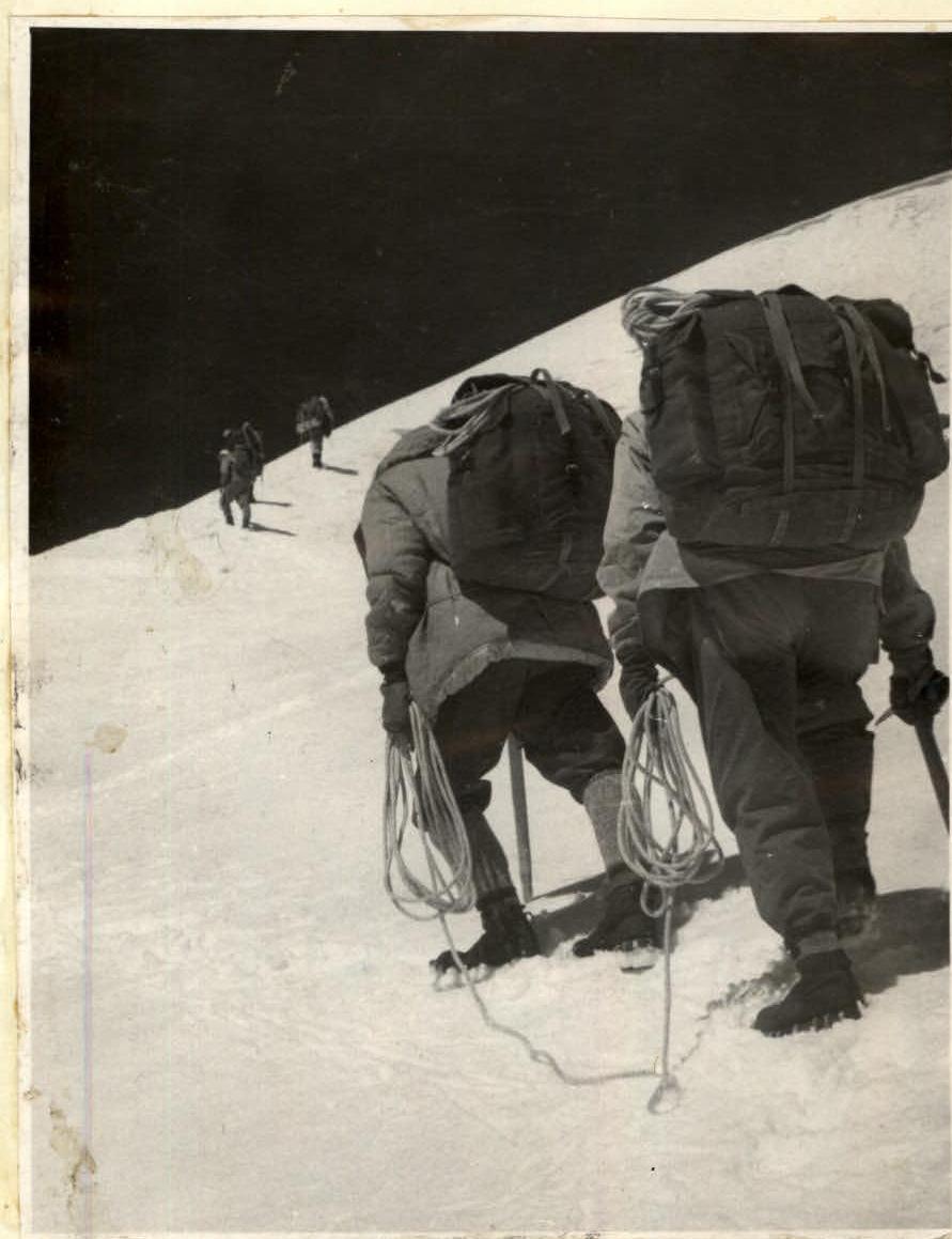
Height "6500". Ahead lies a long snow-ice ridge. It's time to put on crampons. The ridge is fairly simple (R36-R37), but the height is already felt; it's cold, and a strong wind blows. For the first time, we put on insulated face masks.
The snow-ice ridge turns into a rock ridge, also initially not complex (R37-R38). We move simultaneously.
We approach the last rock ascent, bristling with large teeth. Zigzagging between them, the path goes straight up along the ridge (R38-R39).
From the highest point of the ascent, the ridge becomes more gentle. We move along the ridge (R39-R40). In three places, there is alternate belaying via steps; short but sharp snow ridges are traversed. At the end of the rock section of the ridge, there is an ice "shulda" where a good overnight stay is set up.
(6700 m) (R38-R39) August 20, 1968. From the overnight stay, a simple snow-ice ridge continues upward (R40-R41).
Having ascended along it to rock outcrops, the path goes around them on the left (in the direction of travel) along a snow slope (R41-R42) in the direction of our cache, which was located at a height of 6900 m in an ice crevasse. We arrived at the cache at 15:00 and stopped for overnight stay.
At 17:30, a group of our assistants, having successfully completed the ascent, descended from the summit of Peak Kommunizma, having spent the night before the assault on a height of 7300 m, and set up a bivouac next to us.
On the ridge. (R40–R41) August 21, 1968. We departed at 9:00 for the assault. The auxiliary group went down to the 6200 m plateau.
The path from the crevasse goes up along a snow-ice slope (R42-R43) in the direction of the snow saddle of the ridge - 7000 m. The snow-ice cover is very hard; we go on crampons.
From the saddle, we go up along the ridge to the left. The ridge is simple and wide (R43-R44).
Closer to the summit, the ridge becomes slightly steeper (R44-R45). The weather deteriorates; a strong cold wind blows. We go in masks. Under the very summit, there are scree slopes. We reached the summit at 14:00 and met a group from the "Burevestnik" society, who had ascended to the summit from the Fortambek glacier via the Pamir plateau.
We descended to our tents along the ascent path by 17:00.
August 22-26, 1968. The assault group, together with the auxiliary group, descended to the base camp along the path taken by E. TAMM.
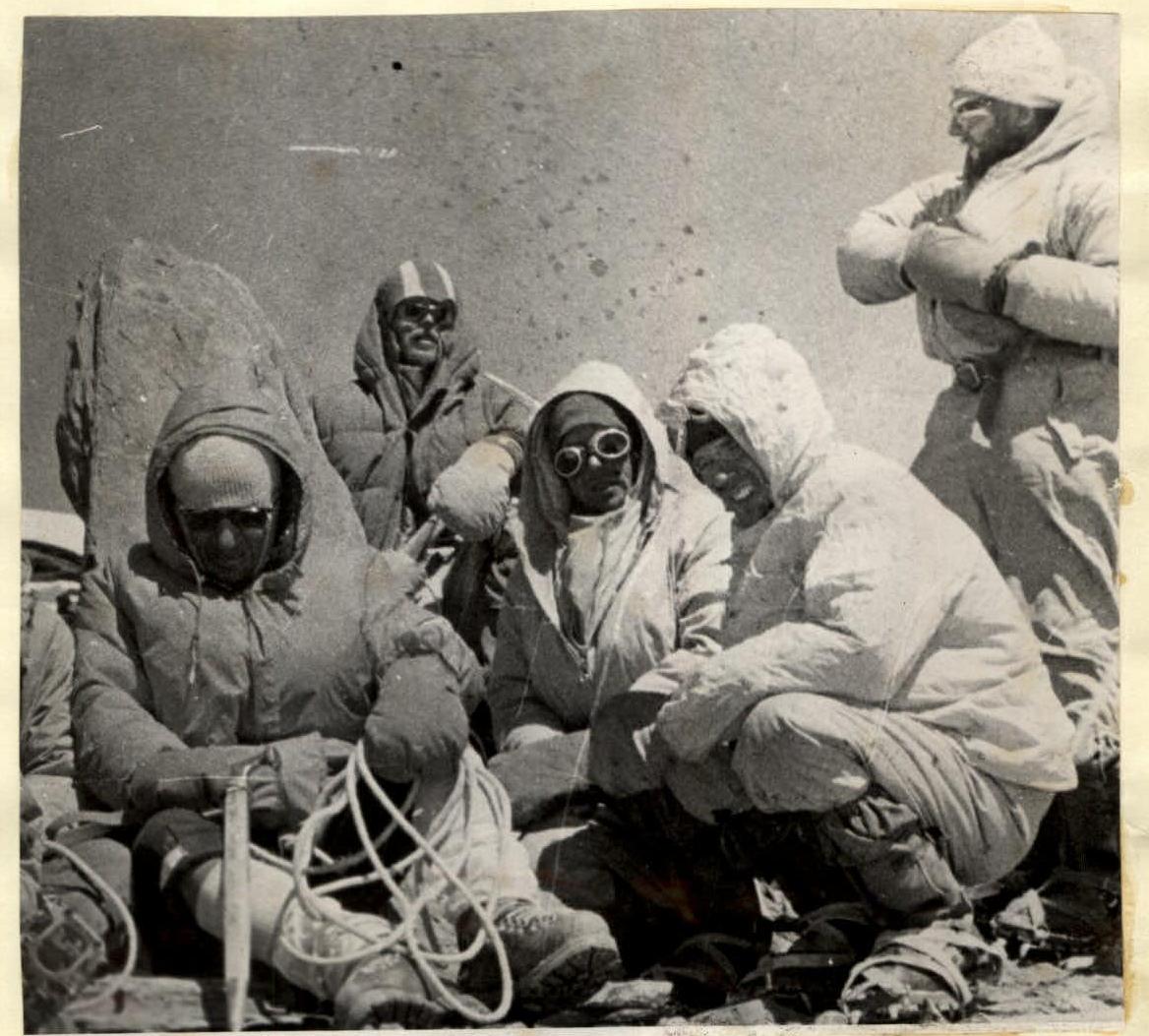
"SUMMIT!"
Table of main characteristics of the route to Peak Kommunizma via the W counterfort
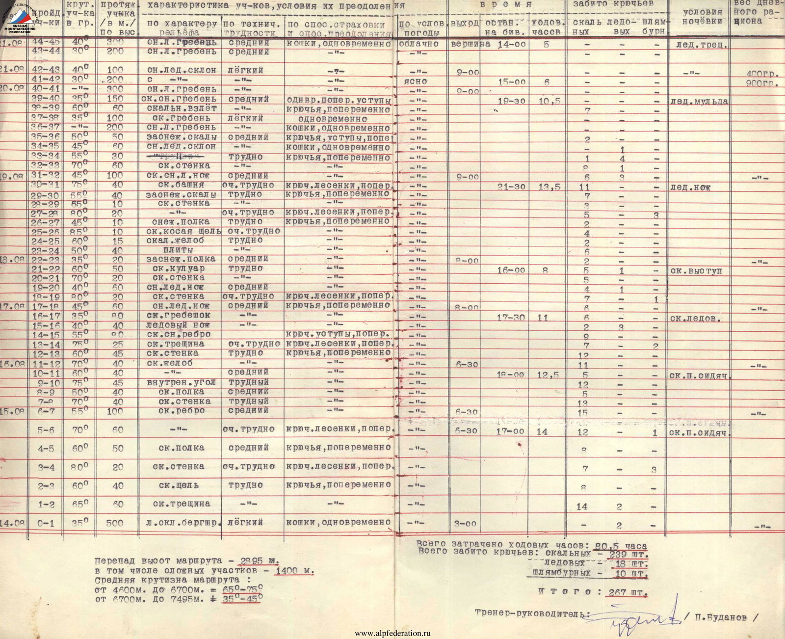
| № | Section | Steepness of section, ° | Length of section, m | Characteristics of section (relief) | Technical difficulties | Method of belaying and overcoming | Weather conditions | Exit to bivouac | Time taken, h | Pitons driven: rock | Pitons driven: ice | Pitons driven: expansion | Overnight stay conditions | Weight of daily ration |
|---|---|---|---|---|---|---|---|---|---|---|---|---|---|---|
| R44–R45 | 40 | 300 | sn.ice ridge | medium | crampons, simultaneous | cloudy | summit | 14:00 | 5 | ice crev. | ||||
| R43–R44 | 300 | sn.ice ridge | medium | " | " | |||||||||
| R42–R43 | 400 | sn.ice slope | easy | " | " | 9:00 | ||||||||
| R41–R42 | 300 | " | " | " | " | 15:00 | 6 | 400 gr. | ||||||
| R40–R41 | 300 | sn.ice ridge | " | " | clear | 0:00 | 900 gr. | |||||||
| R39–R40 | 350 | rock sn. ridge | medium | single, transverse steps | " | 19:30 | 10.5 | 7 | ice hollow | |||||
| R38–R39 | 60 | rock ascent | " | pitons, alternate | " | |||||||||
| R37–R38 | 350 | rock ridge | easy | simultaneous | " | 7 | ||||||||
| R36–R37 | 200 | sn.ice ridge | " | crampons, simultaneous | " | |||||||||
| R35–R36 | 500 | snow-covered rocks | medium | pitons, steps, transverse | " | 2 | 1 | |||||||
| R34–R35 | 450 | sn.ice slope | " | crampons, simultaneous | " | 1 | 4 | |||||||
| R33–R34 | 550 | rock wall | hard | pitons, alternate | " | 1 | 4 | |||||||
| R32–R33 | 700 | rock wall | " | " | " | 1 | 4 | |||||||
| R31–R32 | 450 | rock sn.ice knife | medium | " | " | 9:00 | 6 | 3 | ||||||
| R30–R31 | 750 | rock tower | very hard | pitons, ladders, transverse | " | 21:30 | 13.5 | 11 | ice knife | |||||
| R29–R30 | 550 | snow-covered rocks | hard | pitons, alternate | " | 7 | ||||||||
| R28–R29 | 650 | rock wall | " | " | " | 3 | ||||||||
| R27–R28 | 80 | rock wall | very hard | pitons, ladders, transverse | " | 5 | 3 | |||||||
| R26–R27 | 450 | snow shelf | hard | pitons, alternate | " | 2 | ||||||||
| R25–R26 | 850 | rock diagonal crack | very hard | " | " | 4 | ||||||||
| R24–R25 | 600 | rock gully | hard | " | " | 2 | ||||||||
| R23–R24 | 500 | slabs | " | " | " | 6 | ||||||||
| R22–R23 | 350 | snow-covered shelf | medium | " | 9:00 | 2 | ||||||||
| R21–R22 | 600 | rock couloir | hard | " | " | 16:00 | 8 | 5 | 1 | rock ledge | ||||
| R20–R21 | 700 | rock wall | " | " | " | 5 | ||||||||
| R19–R20 | 400 | sn.ice knife | medium | " | " | 4 | ||||||||
| R18–R19 | 80 | rock wall | very hard | pitons, ladders, transverse | " | 7 | 1 | |||||||
| R17–R18 | 450 | sn.ice knife | medium | pitons, alternate | " | 8:00 | 6 | |||||||
| R16–R17 | 350 | rock ridge | " | " | " | 17:30 | 11 | 6 | rock ice | |||||
| R15–R16 | 400 | ice knife | " | " | " | 2 | 3 | |||||||
| R14–R15 | 550 | rock sn. ridge | " | pitons, steps, transverse | " | 9 | ||||||||
| R13–R14 | 750 | rock crack | very hard | pitons, ladders, transverse | " | 7 | ||||||||
| R12–R13 | 600 | rock wall | hard | pitons, alternate | " | 12 | 2 | |||||||
| R11–R12 | 700 | rock gully | " | " | " | 6:30 | 11 | |||||||
| R10–R11 | 600 | sn. gully | medium | " | " | 10:00 | 12.5 | 5 | rock platform, semi-sitting | |||||
| R9–R10 | 750 | internal angle | hard | " | " | 13 | 12 | |||||||
| R8–R9 | 500 | rock shelf | medium | " | " | 5 | ||||||||
| R7–R8 | 700 | rock wall | hard | " | " | 13 | ||||||||
| R6–R7 | 550 | rock ridge | medium | " | " | 6:30 | 15 | |||||||
| R5–R6 | 700 | rock ridge | very hard | pitons, ladders, transverse | " | 6:30 | 17:00 | 14 | 12 | 1 | rock platform, semi-sitting | |||
| R4–R5 | 600 | rock shelf | medium | pitons, alternate | " | 8 | ||||||||
| R3–R4 | 800 | rock wall | very hard | pitons, ladders, transverse | " | 7 | 3 | |||||||
| R2–R3 | 600 | rock gap | hard | pitons, alternate | " | 8 | ||||||||
| R1–R2 | 650 | rock crack | " | " | " | 14 | 2 | |||||||
| R0–R1 | 350 | ice rock bergschrund | easy | crampons, simultaneous | " | 3:00 | 2 |
Height difference on the route - 2995 m. Including complex sections - 1400 m. Average steepness of the route: from 4600 m to 6700 m = 65-75° from 6700 m to 7495 m = 35-45° Total time taken: 80.5 h. Total pitons driven: rock 239 pcs. ice 18 pcs. expansion 10 pcs. Total: 267 pcs.
Coach-leader: / P. Budanov /