REPORT
on the ascent of Peak Kommunisticheskoy Akademii via the Southwest Face,
carried out as part of the USSR Championship in the high-altitude and technical class


Map-scheme of the ascent area

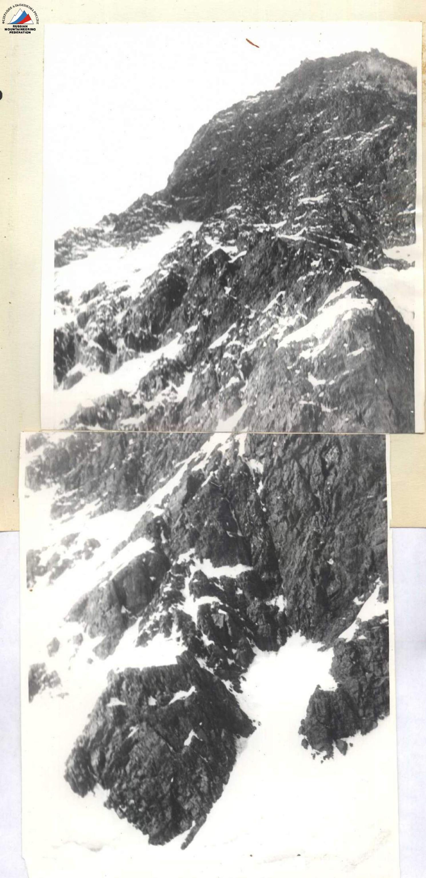
SOUTHWEST FACE AFTER SNOWFALL. PHOTO TAKEN FROM THE AREA OF PEAK 6040 m.
The organizational and tactical plan for the ascent was finalized after reconnaissance and visual observation of the route. The plan was as follows:
Day one: Approach from the base camp to the second assault camp.
Day two: Approach from the second assault camp under the wall, setting up the third assault camp, processing the lower part of the wall, and observing the regime of avalanches and rockfall.
Processing the lower part of the wall is necessary due to the lack of suitable bivouac sites.
Additional observation of rockfall and avalanches is required due to intense snowmelt during the initial period of the expedition.
Day three: Passing the processed sections and reaching the upper part of the lower wall. Overnight on the wall.
Days four and five: Passing the lower wall and the counterfort (ridge). Overnight on the counterfort.
Day six: Passing the snowy ridge. Processing the central tower. Overnight under the central tower.
Day seven: Passing the central tower. Overnight on the upper part of the central tower or on the pre-summit ridge.
Day eight: Passing the pre-summit ridge, the South summit of Peak Kommunisticheskoy Akademii, and descending to the saddle between the South and North summits.
Day nine: Ascending to the North summit, descending to the 5500 m pass, and further to the III assault camp.
Day ten: Descending from the III assault camp to the base camp. Days eleven and twelve are reserve days in case of bad weather.
Potential bivouac sites were chosen based on observations of rockfall.
To ensure the ascent, a group of four had the following equipment:
- main ropes 40 m × 4 (considering the need to process individual sections and pass complex areas using a double rope)
- auxiliary rope 40 m × 1
- Pamiroka tent - 1
- rock pitons - 70 pcs.
- carabiners - 30 pcs.
- rock hammers - 3 pcs.
- crampons - 2 pairs
- ice pitons - 5 pcs.
- "Vitalka" radio station - 1 pc.
- signal rockets - 14 pcs.
- "Febus" primus stove - 1 pc.
- gasoline - 3.5 l
- spare goggles - 1 pair
- first aid kit - 1 pc.
- braking block for rope retrieval - 1 pc.
- drill - 1 pc.
- expansion pitons - 15 pcs.
- ladders - 4 pcs.
- expendable reepschnur - 15 m
Due to the group consisting of only four people and the weight of the equipment being a significant issue, it was decided to bring:
- 2 sleeping bags
- 2 pairs of down pants
All team members had down jackets. To minimize weight, special attention was paid to selecting food. Provisions for the team were planned for 10 days, with a focus on sublimated products.
To ensure safety, a system of signaling and communication was developed with the parallel group led by Nekrasov V. N., the group led by Bandurovsky V. A., and observers in the I assault camp.
Communication with Nekrasov's group was carried out using "Vitalka" radio stations three times a day:
- 8:00
- 14:00
- 20:30
Additionally, at 21:00, rocket signaling was conducted between the three groups and the observers. Observers in the base camp had radio communication.
In case of necessity, either Nekrasov's group or Bandurovsky's group could provide assistance.
The rope teams were formed as follows:
- Matyushin L. M. - Listopadov V. V.
- Starlychanov V. D. - Chichinadze M. G.
The teams were formed to be equivalent, allowing the lead climbers to alternate without compromising safety. The distribution of tasks within the teams varied depending on the situation.
The organizational and tactical plan was largely executed. The bivouac sites coincided with the planned locations and were safe. The team had enough provisions, and after the ascent, there was a 2-day reserve of sublimated products.
The weather caused some adjustments to the plan:
- 4 days of bad weather (August 6-9) prevented the team from starting the route;
- heavy snowfall, occasional rain, and lack of visibility forced the team to spend 4 days in the III assault camp;
- the reserve of food and gasoline created for bad weather allowed the team to start the ascent after the weather improved.
Description of the Ascent Route
(ascent diary) On August 3, at 9:00, the assault group (Matyushin L. V., Starlychanov V. D., Listopadov V. V., Chichinadze M. G.) left the base camp in the upper reaches of the Vanch valley, crossed the Abdugor river by bridge, and ascended to the glacial lake along the "pocket" of the left (orographically) moraine of the Russian Geographical Society glacier.
The RGO glacier is covered with surface moraine in its lower part and has many transverse crevices. The journey from the lower part of the glacier tongue to the glacial lake takes 3.5 hours. The glacial lake is bypassed on the left, leading to the central part of the glacier. After 2 hours of walking on the surface moraine, we reach the clean ice, and after another 1.5 hours, we arrive at the I assault camp above the confluence of the RGO and Krasnoarmeets glaciers.
We stop for the night at the I assault camp, which takes 6-7 hours to reach from the base camp. There is water (lakes), a clear view of the southwest face of Peak Kommunisticheskoy Akademii, and reliable VHF radio communication with the base camp.
August 4. From the I assault camp, we head to the upper reaches of the RGO glacier. The most convenient path is along the middle, most gentle part of the glacier until the beginning of the icefall (2-2.5 hours). We pass the lower part of the first step of the icefall on the left (orographically), then ascend to the lateral spur of the ridge of Peak Kommunisticheskoy Akademii, traverse it, and bypass the upper part of the first step of the RGO glacier icefall via a snowy couloir (15-18 ropes). The rocky section involves steep (75-80°) climbing with piton protection. We bivouac on the spur of the ridge (II assault camp), 5-6 hours from the first assault camp.
August 5 - traverse the snowy slopes of the ridge, bypassing the icefall on the right, and reach the firn plateau of the RGO glacier at the base of the southwest face.
Over the past week, there has been less snow on the wall. The sunny weather and snowmelt may have altered the rockfall regime, especially in the upper part of the wall. We decide to conduct additional observation.
At 14:30, on the II step of the RGO glacier, we set up an intermediate camp. The team of Matyushin L. M. and Starlychanov V. D. observes the route.
The lower part of the route above the bergschrund consists of steep (65-70°) rocks without visible bivouac sites.
The lower wall forms an irregular rhombus with a sloping snow shelf at the top. The edges of the "rhombus" are rockfall-prone, especially the right one.
We plan the route on the left side of the "rhombus".
Considering the lack of suitable bivouac sites on the lower wall, we decide to process the lower rocks. At 13:00, the team of Chichinadze M. G. and Listopadov V. V. starts processing the route.
They overcome the bergschrund and ascend to the rocks, slightly left of the center of the "rhombus". The first difficult climbing section (R1) leads to smoothed rocks. Further climbing involves diverse relief, with easy-to-climb ledges and holds at the bottom, monolithic rock sections in the middle, and slabs at the top.
Over 6 hours, the team of Chichinadze and Listopadov covers 7 ropes, processing the "rhombus" and the lower part of the "triangle". The weather is good, with occasional clouds covering the upper part of the wall.
By evening, the weather deteriorates, and it starts snowing in the III assault camp.
August 6-9, we wait out the bad weather in the III base camp.
The snowfall continues throughout the night and the next three days. The upper cirque of the RGO glacier is shrouded in dense, low-hanging clouds, and visibility is limited.
Despite the heavy snowfall, rockfall and avalanches continue, including large avalanches at night.
On August 9, the weather is still bad in the morning, but it improves in the afternoon.
There is a lot of snow on the wall, even on the lower "rhombus".
We observe the wall's behavior after the snowfall.
On August 10, we start the ascent at 9:00. Although the sun has not yet illuminated the cirque and the wall, we can navigate the processed sections.
It takes 4 hours to pass the processed sections (R1-R6).
On section R7, we encounter difficult climbing - a monolithic wall with a small overhang. We use ladders to overcome it, and retrieve the rucksacks.
After the overhang, there is about 0.5 rope of difficult climbing, followed by a narrow snow ridge (R9) leading to the upper part of the triangular wall.
Section R10 involves a narrow, vertical chimney:
- wet at the bottom,
- with icicles in the upper part,
- and a "plug" of hanging rocks in the lower third.
Climbing is very difficult, without rucksacks, using ladders.
After the chimney, we encounter steep, crumbling rocks (R11), with inclined ledges and outcrops. We decide to stop for the night on one of the ledges.
The bivouac site is not ideal, with a narrow platform. We spend about 2 hours setting up the tent, resulting in a sitting bivouac.
August 11. We start the ascent at 9:00. The first team (Matyushin - Starlychanov) works on R12.
Two ropes of straightforward climbing on snowy rocks with ledges and outcrops follow.
A short traverse to the right under hanging rocks (R13).
Before reaching the ridge (R14), we encounter a sheer wall. We overcome it via a narrow chimney. Climbing is very difficult, using ladders.
The section R14, completing the lower wall, is passed without rucksacks.
We change the lead team, and Chichinadze - Listopadov take the lead.
Ahead lies a narrow rock counterfort with snow cornices. The beginning of the counterfort (R15) is straightforward and leads to the first "bastion".
The "bastion" (R16-R19) is bypassed on the right via narrow rock ledges. Climbing is difficult, with piton protection.
We continue along the counterfort, overcoming a series of "bastions" and reaching the upper part.
The counterfort becomes narrower and knife-like, with a snow cornice.
We cut the snow cornice and set up a tent. The bivouac is sitting.
The weather is good, but very windy and cold.
August 12. We start moving along the counterfort at 8:30.
The snow cornice (R20) is bypassed on the right.
The second "bastion" (R21-R24) is overcome:
- initially, directly via a steep rocky ridge,
- then, bypassing the hanging rocks on the right.
Climbing is difficult, with piton protection.
The "bastion" ends with a snowy ridge with cornices.
Section R25 is traversed on the right side of the counterfort:
- steep (60-65°) iced-firn slope with rock outcrops,
- piton protection, with rock and ice pitons.
The "bastion" bypass is complete.
Ahead lies a snowy ridge with rock outcrops, followed by a steep snowy-iced ridge.
Observation reveals that this snowy ridge separates two couloirs and is a natural barrier for rocks falling from the central tower. We decide to pass it in the morning.
We choose a bivouac site under a rocky wall.
The snowy ridge (R26) is passed using perils.
The team of Chichinadze - Listopadov sets up the bivouac, while Matyushin - Starlychanov processes the last rocky section.
The bivouac site is wide and comfortable, with a wall built from snow bricks for protection from the wind.
The rocky section above the bivouac (R27) involves a "bastion" on the snowy ridge:
- not very steep (50-55°), but smoothed rocks,
- we leave the rope in place and return to the bivouac.
At 20:30, we establish radio contact with Nekrasov's group, exchanging information.
Nekrasov warns about the rockfall danger on the section we are about to pass and recommends an early start.
August 13. We plan an early start.
At 8:00, the team of Chichinadze - Listopadov begins the ascent.
Movement on the snowy ridge (R28):
- alternating lead teams,
- using perils and protection via ice axes and ice pitons.
The snowy ridge is not well-defined, with numerous avalanche grooves.
The snow is dry and loose, with a thin crust.
By the time we pass this section, many avalanches have occurred, and there are exposed ice areas.
The central tower wall is not yet illuminated by the sun, reducing the risk of rockfall.
We continue to monitor the rocks.
After 5 ropes of snowy-iced slope, we reach a rocky belt.
A short rocky wall (R29) is followed by a rocky ledge (R30) leading to smoothed rocks (R31).
The rocks are steep (up to 60-65°), snowy, and challenging to climb due to strong wind and cold.
Despite the sun illuminating the slope, there are sections with icicles.
After the smoothed rocks, we encounter a section of crumbling rocks (R32), followed by a steep snowy slope (R33) leading to the central tower walls.
Preliminary observations indicate that there are no suitable bivouac sites on the central tower wall.
We decide to bivouac on the snowy slope (R33) and process the base of the tower.
The snowy slope is steep and challenging for setting up a bivouac.
The team of Matyushin - Starlychanov starts processing the central tower rocks.
We plan to ascend the tower slightly to the right of the central part, as the left side is crumbling and prone to rockfall.
On August 14, we pass the processed sections and continue ascending.
On August 15, we overcome the last ascent of the central tower.
The "roof" of the tower involves a series of converging ridges separated by snowy grooves.
We pass the "roof" with alternating teams and piton protection.
The relief is diverse, with short vertical sections alternating with inclined, snowy ledges.
On one of the ledges, we set up a bivouac.
On August 16, we continue the ascent.
We pass a series of rocky sections, including steep walls, inclined slabs, and crumbling rocks.
In the upper part of the "roof", we leave the third control point.
From the control point, we traverse a snowy-firn slope (R55) and reach the South summit.
On the summit, we find a note from Nekrasov's group and the original ascenders' note.
We begin our descent to the saddle between the South and North summits.
The descent involves a steep, rocky ridge with small "bastions".
We bypass the large "bastion" on the left and descend to the saddle.
The saddle is wide and flat, making it an ideal bivouac site.
On August 17, we ascend to the North summit.
The ascent involves a steep, rocky ridge with a "bastion".
We overcome the "bastion" and reach the summit.
The weather is poor, with wind, fog, and clouds covering the surrounding peaks.
We descend via the Northwest ridge to the 5500 m pass.
The descent is combined, involving rocky, snowy, and iced sections.
We meet Nekrasov's group on the pass.
On August 18, we return to the base camp.
Conclusions on the Ascent
- The group successfully completed the first ascent of the Southwest face to the South summit of Peak Kommunisticheskoy Akademii, followed by a traverse of the North summit and descent via the Northwest ridge to the 5500 m pass, in accordance with the planned organizational and tactical plans and the stated alternative route in the high-altitude and technical class.
- The choice of the alternative route was due to the weather conditions (abundance of snow) in the 1972 season, which determined the high rockfall danger on the lower part of the wall and the risk of snow avalanches on the upper part of the main route.
- The meteorological conditions during the ascent were unstable, with heavy snowfalls on August 6, 7, and 8, and variable weather on August 9, 14, 15, 16, and 17. Strong, cold winds were present.
- The route on the Southwest face can be conditionally divided into 4 parts: the lower wall, the middle part (counterfort), the central tower, and the "roof" of the tower. The average steepness of the route until the snowy-firn pre-summit ridge is 70°. The height difference is 2000-2100 m, and the route length is 2850 m (to the South summit). The most complex sections are the lower wall (height difference 470-480 m, average steepness 75-76°) and the central tower (height difference 420-430 m, average steepness 80°). On these sections, movement was often without rucksacks, and preliminary route processing was used.
- A total of 182 rock pitons, 5 ice pitons, and 15 expansion pitons were used during the ascent. The route required 80 hours of climbing time from the base of the wall to the South summit. The total ascent time (to the North summit) was 85 hours.
- The route is logical, as it is close to a straight line between the base of the wall and the summit, and is generally safe from rockfall and avalanches if timed correctly. The most rockfall-prone sections are the snowy ridge (R28), the right part of the lower wall, and the left side of the central tower.
The route is worthy of the 6B category. Its complexity is comparable to the South wall of Peak Revolyutsii and the Northwest ridge of Peak 26 Baku Commissars.
In terms of length, the route exceeds the route on the South wall to Peak Kommunisticheskoy Akademii, and in terms of steepness, it is comparable.
- There were no cases of falls or lost equipment during the ascent. The climb was completed without injuries or illnesses. The acclimatization of the participants was sufficient. There were no disciplinary issues.
- Rocket signaling between the assault group and Nekrasov's group, Bandurovsky's group, and the observation group was carried out regularly according to the established signals. Radio communication with Nekrasov's group was satisfactory.
- The route is extremely interesting and diverse. It is recommended for groups with experience in high-category wall ascents.
Table of Main Characteristics of the Ascent Route
Ascent route: Southwest face of Peak Kommunisticheskoy Akademii.
Height difference from the glacier to the South summit: 2000-2100 m.
Average steepness of the wall section: 70°.
Average steepness of the lower wall: 75° (height difference 470-480 m).
Average steepness of the central tower: 80° (height difference 420-430 m).
Average steepness of the route on the counterfort (traverse): 63° (height difference 600-640 m).
Average steepness of the "roof": 64° (height difference 440-450 m).
| Date | Passed Sections | Average Steepness of Section | Section Length (in 40-m ropes) | Characteristics of Sections and Climbing Conditions |
|---|---|---|---|---|
| by relief character | ||||
| 10.08.1972 | R1 (x) | 45° | 2 | Snowy-firn slope |
| R2 (x) | 65–70° | 1 | Chimney | |
| R3 (x) | 65–70° | 1 | Smoothed rocks ("ram's foreheads") | |
| R4 (x) | 55–60° | 0.5 | Inclined snowy ledge | |
| R5 (x) | 65–70° | 1.5 | Snowy rocks | |
| R6 (x) | 80° | 1 | Monolithic rock wall | |
| R7 | 85–90° | 1 | Rock wall with small overhang | |
| R8 | 80° | 0.5 | Rock wall | |
| R9 | 55–60° | 0.5 | Snowy ridge | |
| R10 | 90° | 1.0 | Chimney with icicles and hanging rocks | |
| R11 | 70° | 2 | Crumbling rocks with snow | |
| 11.08.1972 | R12 | 65–70° | 2 | Crumbling rocks with snow, upper part - slabs |
| R13 | 70–75° | 0.5 | Rock ledge under hanging rocks | |
| R14 | 90° | 1.0 | Narrow chimney-crack with "plug" at the bottom and ice at the top | |
| R15 | 55–60° | 0.5 | Snowy ridge | |
| R16 | 70–80° | 1.5 | Monolithic rocks with small ledges | |
| R17 | 80–85° | 0.3 | Rock wall | |
| R18 | 65–70° | 1.5 | Boundary of rocks, snow, and ice | |
| R19 | 80° | 0.8 | Chimney with hanging rocks at the bottom, transitioning to an internal angle of slabs | |
| 12.08.1972 | R20 | 40–50° | 0.7 | Snowy cornice on a narrow rocky ridge |
| R21 | 55–60° | 1 | Sharp rocky ridge | |
| R22 | 70–75° | 0.7 | Narrow, inclined rock ledge | |
| R23 | 70–75° | 2.0 | "Bastion" (on the counterfort ridge) | |
| R24 | 50–55° | 1.0 | Crumbling rocks on the right slope of the counterfort | |
| R25 | 60–65° | 2.0 | Iced-firn slope with rock outcrops | |
| R26 | 50° | 1 | Snowy ridge with rock outcrops ("ram's foreheads") | |
| 13.08.1972 | R27 (x) | 50–55° | 1 | Smoothed rocks ("ram's foreheads") with snow and "live" stones |
| R28 | 50–55° | 5 | Snowy-firn ridge with exposed ice | |
| R29 | 80° | 0.15 | Rock wall | |
| R30 | 75–80° | 0.75 | Rock ledge | |
| R31 | 60–65° | 1.0 | Smoothed rocks ("ram's foreheads") with snow | |
| R32 | 55–60° | 0.5 | Crumbling, snowy rocks | |
| R33 | 55–60° | 1.5 | Snowy slope | |
| 14.08.1972 | R34 (x) | 75–80° | 2 | Rock, partly snowy ledge under hanging rocks |
| R35 (x) | 80° | 1.0 | Rock wall | |
| R36 (x) | 80–85° | 3.0 | Boundary of rocks and snow | |
| R37 | 75–80° | 2 | Monolithic rock blocks with diverse relief | |
| R38 | 65–70° | 0.5 | Belt of crumbling rocks with snowy ledges | |
| 15.08.1972 | R39 | 75–80° | 3 | Monolithic rocks with diverse relief (slabs, small overhangs) |
| R40 | 70–75° | 0.25 | Inclined ledge-crack | |
| R41 | 75–80° | 1.0 | Chimney | |
| R42 | 80° | 0.25 | Rock wall | |
| R43 | 60–65° | 4 | Implicitly defined ridge ("roof"). Alternating crumbling rocks, snowy ledges, and steep rock walls. | |
| 16.08.1972 | R44 | 80–85° | 0.15 | Rock wall |
| R45 | 55–60° | 1.0 | Crumbling rocks | |
| R46 | 60–65° | 0.2 | Slab with narrow ledge | |
| R47 | 55–60° | 0.5 | Crumbling rocks with snow | |
| R48 | 60–65° | 0.5 | "Ram's foreheads" with snow | |
| R49 | 75–80° | 1.0 | Rock wall with ledge and internal angle |


