Ascent Passport
- Ascent class: high-altitude technical
- Ascent area: Darvaz Range
- Peak, its height, and ascent route: peak Kommunisticheskoy Akademii, 6432 m, via the SW wall
- Complexity category: 6B, third ascent
- Route characteristics: average steepness — 65° total height difference — 2092 m route length — 2399 m and sections in m
| R1 | — | 60 |
|---|---|---|
| R2 | — | 145 |
| R3 | — | 235 |
| R4 | — | 585 |
| R5 | — | 1285 |
| R6 | — | 89 |
- Pitons driven: for belaying: rock + chocks — 165 ice — 29 bolt — 1 for creating artificial anchors — 1
- Total travel hours: for creating artificial anchors — 48 h 30 min
- Number of nights and their characteristics: 3 — lying, 3 — sitting, 1 — semi-reclining
- Surname, name, patronymic of the leader and participants, and their sports qualification:
- Kompaneets Igor Vasilievich — leader CMS
- Almazkin Alexey Nikolaevich — participant CMS
- Kiselev Anatoly Mikhailovich — participant MS
- Korsakov Alexander Arsenievich — participant CMS
- Morozov Vyacheslav Valentinovich — participant CMS
- Salikov Alexander Mikhailovich — participant CMS
- Shevchenko Nikolai Alekseevich — participant MS
- Date of departure on the route: August 5, 1979 and return from the route: August 12, 1979
- Team coach: MS USSR Shevchenko Nikolai Alekseevich
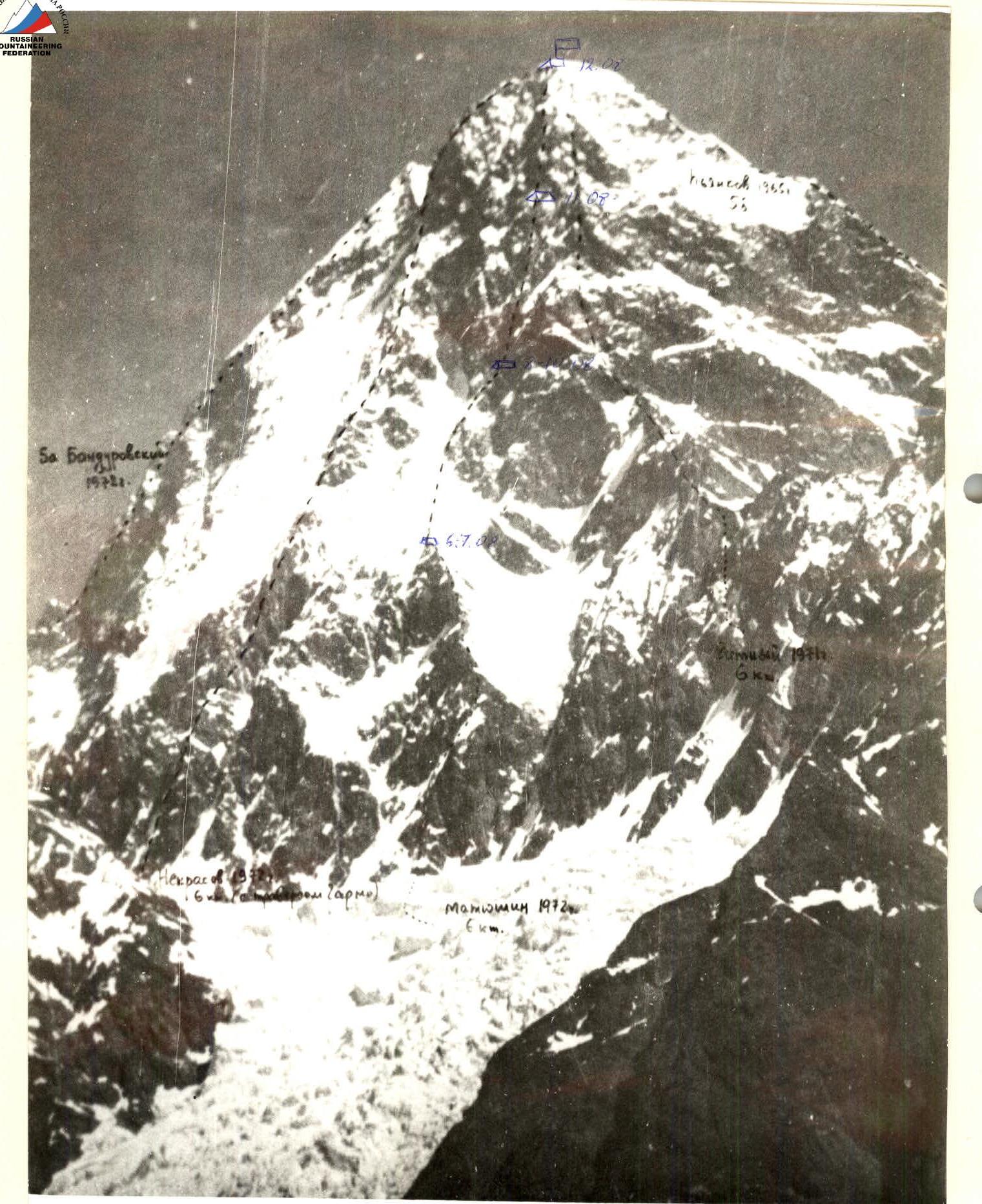
Table of main route characteristics
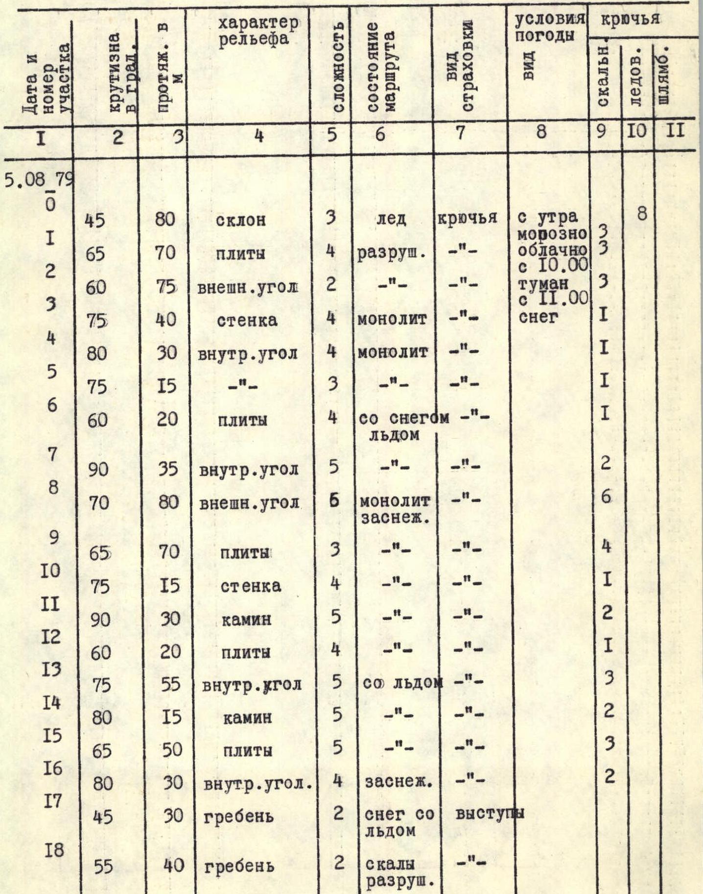
| Date and section number | Steepness in ° | Length in m | Terrain character | Difficulty | Route condition | Belay type | Weather conditions | Rock | Ice | Bolt |
|---|---|---|---|---|---|---|---|---|---|---|
| August 5, 1979 | ||||||||||
| R0 | 45° | 80 m | slope | 3 | ice | pitons | frosty in the morning, cloudy | 8 | ||
| R1 | 65° | 70 m | slabs | 4 | destroyed | -" | frosty, cloudy from 10:00 | 3 | ||
| R2 | 60° | 75 m | outer corner | 2 | -" | fog from 11:00, snow | 3 | |||
| R3 | 75° | 40 m | wall | 4 | monolith | -" | 1 | |||
| R4 | 80° | 30 m | inner corner | 4 | monolith | -" | 1 | |||
| R5 | 75° | 15 m | -" | 3 | -" | 1 | ||||
| R6 | 60° | 20 m | slabs | 4 | with snow, ice | -" | 1 | |||
| R7 | 90° | 35 m | inner corner | 5 | -" | -" | 2 | |||
| R8 | 70° | 80 m | outer corner | 6 | monolith, snowy | -" | 6 | |||
| R9 | 65° | 70 m | slabs | 3 | -" | 4 | ||||
| R10 | 75° | 15 m | wall | 4 | -" | 1 | ||||
| R11 | 90° | 30 m | chimney | 5 | -" | 2 | ||||
| R12 | 60° | 20 m | slabs | 4 | -" | 1 | ||||
| R13 | 75° | 55 m | inner corner | 5 | with ice | -" | 3 | |||
| R14 | 80° | 15 m | chimney | 5 | -" | 2 | ||||
| R15 | 65° | 50 m | slabs | 5 | -" | -" | 3 | |||
| R16 | 80° | 30 m | inner corner | 4 | snowy | -" | 2 | |||
| R17 | 45° | 30 m | ridge | 2 | snow with ice | rock outcrops | 1 | |||
| R18 | 55° | 40 m | ridge | 2 | destroyed rocks | -" | ||||
| R19 | 70° | 110 m | outer corner | 4 | destroyed rocks | pitons | 6 | |||
| R20 | 50° | 40 m | wall | 5 | ice | -" | 1 | 3 | ||
| August 7, 1979 | Overnight stays on snowy areas, lying | |||||||||
| R21 | 60° | 220 m | edge | 5 | ice | pitons | frosty and cloudy in the morning | 16 | ||
| R22 | 65° | 120 m | rock "ram's foreheads" | 5 | icy | -" | then snowfall, wind | 11 | ||
| R23 | 55° | 50 m | couloir | 4 | ice with firn | -" | 1 | 2 | ||
| R24 | 70° | 70 m | "ram's foreheads" | 5 | snowy with ice | -" | 8 | |||
| R25 | 45° | 40 m | traverse | 5 | -" | 3 | 1 | |||
| August 10, 1979 | Overnight stays on an ice shelf under an overhang, sitting | |||||||||
| R26 | 80° | 10 m | wall | 5 | snowy with ice | pitons | cold — occasionally foggy | 1 | ||
| R27 | 80° | 5 m | traverse | 6 | -" | and snow in the evening, wind | 2 | |||
| R28 | 75° | 20 m | inner corner | 5 | -" | 2 | ||||
| R29 | 85° | 30 m | wall | 6 | -" | 4 | ||||
| R30 | 85° | 10 m | traverse | 6 | -" | 2 | ||||
| R31 | 70° | 40 m | outer corner | 5 | -" | 4 | ||||
| R32 | 65° | 70 m | slope | 3 | snow, ice, rock | -" | 4 | |||
| islands | ||||||||||
| R33 | 70° | 40 m | inner corner | 4 | snowy | -" | 3 | |||
| R34 | 75° | 40 m | "ram's foreheads" | 6 | snowy with ice | -" | 6 | |||
| R35 | 80° | 80 m | inner corner | 5 | -" | 7 | ||||
| R36 | 70° | 40 m | wall | 4 | -" | -" | 4 | |||
| R37 | 70° | 60 m | traverse | 4 | -" | -" | 4 | |||
| R38 | 70° | 60 m | descent | |||||||
| August 11, 1979 | Overnight stay on scree slopes, semi-reclining | |||||||||
| R39 | 70° | 20 m | wall | 5 | snow with rocks | pitons | wind, occasionally foggy, snow | 3 | ||
| outcrops | ||||||||||
| R40 | 70° | 20 m | wall | 5 | snowy | -" | 2 | |||
| R41 | 65° | 120 m | outer corner | 5 | snowy with ice | -" | 14 | |||
| R42 | 70° | 10 m | slabs | 4 | snowy | -" | 1 | |||
| R43 | 95° | 4 m | cornice | 6 | monolith | -" | 3–1 | |||
| R44 | 70° | 20 m | slabs | 5 | snowy | -" | 3 | |||
| R45 | 65° | 150 m | inner corner | 5 | -" | 17 | ||||
| R46 | 40° | 30 m | slope | 5 | ice, snow | -" | 4 | |||
| R47 | 45° | 10 m | chimney | 4 | snowy | -" | 1 | |||
| R48 | 50° | 40 m | slabs | 4 | -" | 2 |
Brief explanation of the table
August 5, 1979 6:00. The team set out under the wall. Along the left upper part of the RGO glacier, adhering to the slopes of the S. ridge of peak Kommunisticheskoy Akademii, to a snowy plateau, from where steeply upwards, bypassing crevasses, to the left lower part of the rock triangle — the beginning of the wall. 8:00. Autonomous rope teams move under the ice cone on the left (hereinafter, the direction on the route is indicated) from the triangle (R0–R1) towards the outer rock corner, which we approach via slabs (R1–R3). Further up the wall to the right (R3–R4) to an inner corner, which, flattening out, leads to slabs (R4–R7). Along the slabs again using to the right (R7–R8) towards the next inner corner (R8), which leads to the top of the rock triangle. From here the path lies along a steep, weakly expressed counterfort to the snow-ice "sabre". Initially straight ahead (R8–R9), then to the right upwards (R9–R10) and again upwards to a small (1.5 m) ridge. Here we find the 1st cairn with a note from the first ascenders. On the left, we enter a chimney (R10–R11), then to the right upwards (R11–R12) and again straight up along the inner corner, turning into a chimney with ice (R12–R15). We exit into a rock window. From here, to the left upwards to the next inner corner (R15–R16), along which we exit onto the snow-ice ridge. We traverse a bit to the right and up, further along the rocks with ice and the ice wall (R16–R21), we exit onto a steep snowy ridge, where we build two platforms for a bivouac in the snow. 15:00. We stopped for a bivouac under the "sabre".
August 7, 1979 9:00. Started work.
- Up the ice "sabre" (R21–R22) to a rock outcrop of "ram's foreheads", which we pass on the left side.
- Then along the boundary of rocks and ice (R22–R23) and through a couloir (R23–R24) we again exit onto rocks of the "ram's foreheads" type, along which we move upwards (R24–R25).
- Further, we traverse to the right under an overhang (R25–R26), where we set up a bivouac at 16:00.
August 10, 1979 9:00. Started work.
- To the left upwards (R26–R27) from the bivouac, then traverse to the left (R27–R28) and up along the inner corner (R28–R29).
- Again to the right upwards (R29–R30) and traverse to the right (R30–R31), after which straight up (R31–R32).
- Further to the right upwards through a section of snow with rock islands (R32–R33) towards an inner corner, along the left part of which we move upwards (R33–R34).
- Further to the left upwards with an exit onto a rock bastion of the "ram's foreheads" type (R34–R35), which we pass along the outer corner and move to the left into an inner corner (R35–R36).
- At the exit from the inner corner, we find the bivouac of the first ascenders, which we cannot use.
- Having moved up a bit (R36–R37), after traversing to the left (R37–R38), we find good scree slopes below, to which we descend (R38–R39) and set up a bivouac at 19:00.
August 11, 1979 9:30. Resume work on the route.
- Along the left ropes (R38–R39) upwards, then to the left upwards (R39–R40) towards the outer corner and along it (R41–R42) to the left of the vertical walls upwards.
- Then to the left upwards (R42–R43) under a cornice, which we pass with a ladder (R43–R44).
- Further towards the white rock belt (R44–R45) and to the left of it along a wide inner corner (R45–R46).
- Then along the ice with loose snow on it (R46–R47) to an inclined chimney (R47–R48), which leads to the left onto a shoulder.
- From the shoulder to the left upwards, bypassing a sentinel (R48–R49), we enter a narrow couloir, turning into a chimney (R49–R50), leading to the snow-ice base of the summit (R50–R51).
We reached the South summit at 16:30.
August 12, 1979 The path from the S. summit to the N. summit cat. complexity 2–3 took 4 h 30 min.
The descent from the N. summit along the Bandurovsky route cat. complexity 5A towards the "Otradа" pass took us 4 h, and another 2 h from the pass. By 19:00 the team was at the foot of the RGO glacier under the "Otradа" pass.
Descent sections:
- From the N. summit to the "Otradа" pass — there are many ice sections on the descent, but it is quite safe to the pass.
- From the pass — the descent is exposed to rockfall.
Route recommendations: The "sabre" section is exposed to rockfall, and it is better to pass it early in the morning at low temperatures.
From the equipment, it is necessary to have a pair of crampons per rope team and an ice axe for each participant. In addition, a minimum of other equipment:
- Rock pitons — 20
- Chocks — 10
- Ice pitons — 10
- Ladders — 4
Approach to the route
August 2, 1979 From the Base Camp (at the lakes) along the right moraines of the Russian Geographical Society glacier 5 h to the "Green Glade" at the confluence of the Krasnoarmeysky glacier. On the "Green Glade" we set up an observer bivouac at 13:00. The team also had their first overnight stay here. August 3, 1979 The team left the observer bivouac on the "Upper Army overnight stays". 2 h along the RGO glacier, crossing it to the right (hereinafter, the sides of glaciers and rivers are indicated orographically) part, then exit to the left part of the glacier descending from the South cirque of peak Kommunisticheskoy Akademii. Along the left part of the glacier 1 h to its steepest part, then 50 m of medium climbing on a rocky slope of the South ridge of p. Kom. Akademii 80°. Further 80 m traverse to the left (hereinafter, the passage by the group of rocky and other sections of the route is indicated along the way) into a steep couloir, along which 2 h to the Upper Army overnight stays. 12:45. The team stopped for a bivouac. 15:00. The Kompaneets–Korsakov rope team went on reconnaissance under the wall. The path of the upper part of the glacier was reconnoitered, 1 rope length of belays was hung along the path to the wall, and the lower part of the route to the "sabre" was additionally studied. They returned at 17:20.
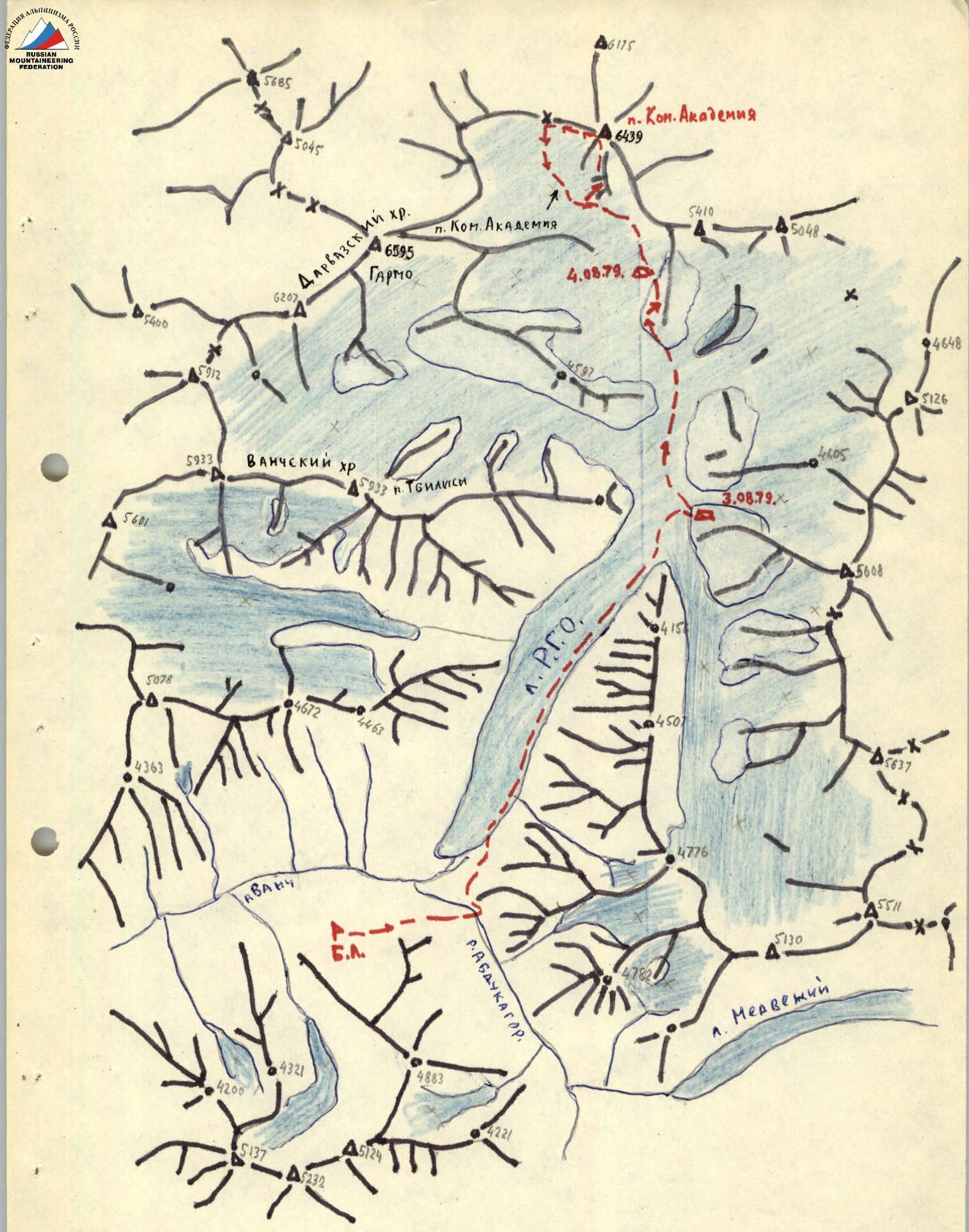
Academii Nauk Range Vanch Range Darvaz Range


