Committee for Physical Culture and Sports under the Council of Ministers of the Kabardino-Balkarian ASSR
Report
on the first ascent via the center of the Southwest face to peak "KOMAKADEMIYA" 6439 m, approximately 6B category of difficulty. CENTRAL PAMIR (region of the "Geographical Society" glacier)
Coach and team captain, Honored Master of Sports of the USSR — Yu. POROKHNYA
Nalchik
September 5–20, 1975
1. Brief geographical description and sporting characteristics of the object of the first ascent. Brief description of the route conditions in the given area (remoteness from alpinist bases and means of communication, features of relief, weather conditions)
Peak "KOMAKADEMIYA" is located in the Central Pamir, in the southwestern part of the Fedchenko glacier, adjacent to the Academy of Sciences range in the area of peak "GARMO". This region is quite remote from populated areas; the nearest settlement, Vanch, from which one can communicate with any city by post and transport (airplanes, cars), is 80 km away from the main base camp near the Geographical Society glacier. Automobiles from the "Khrustalny" mine travel to this location.
The name "peak 'Komaakademii'" appeared on maps compiled by surveyor Dorofeev based on surveys in 1938. In the same year, the first acquaintance of alpinists with the peak took place. An expedition led by N.V. KRYLENKO penetrated from the upper reaches of the Tanymas river to the Fedchenko glacier and "...was struck by two peaks of one mountain, which we," he writes, "from then on called the double-peaked one. They were higher than the others."
The first attempt to conquer this peak was made by alpinists in 1956, but it was unsuccessful. The weather also prevented them from ascending in 1962. Only in 1965 did a team from Uzbekistan conquer the South peak via the Southeast face, winning gold medals in the USSR championship.
Six years later, alpinists returned, and a team from CSKA under the leadership of Bitny ascended via the right part of the Southwest face from the Fedchenko glacier and won silver medals in 1971. Alpinists from the CSKA team under the leadership of Matyushin also won silver medals in 1972 by ascending via the left part of the Southwest face.
The route chosen by the Kabardino-Balkarian ASSR team via the center of the Southwest face goes almost vertically to the South peak from its base — a combined route with a predominance of rocky sections.
The peak is composed of:
- schistose and massive metamorphosed Paleozoic limestones;
- granitoid rocks, strongly weathered, especially in the lower and middle parts of the walls.
The route turned out to be heavily glaciated, especially in the internal corners, with many hanging ice icicles, which significantly complicated the passage, particularly the so-called "black triangle" above the hanging glacier in the center of the wall.
In the upper part:
- loose snow with an ice crust, which had to be broken through with the rand of a boot in the early morning... and sink 30–50 cm.
In the area of peak "Komaakademii", the weather is unstable with frequent winds and snowfalls. It is quite cold at night, and during the day, under the sun, there is very strong ultraviolet radiation.
2. Reconnaissance
Two reconnaissance missions were conducted in preparation for this ascent: July 5–6 and July 15–18. The goals of the reconnaissance were:
- to mark the path along the Geographical Society glacier to the lower step of the icefall, under the counterfort descending from peak 5410 m (see the map of the area);
- acclimatization to an altitude of 3400 m;
- transportation of equipment and food supplies for the main and auxiliary groups — this was done during the first reconnaissance.
During the second reconnaissance:
- the path was laid along the first step of the icefall and further along the couloir to the ridge (see photo № 1), where an observation point was established;
- the path was laid bypassing the second step of the icefall, with the installation of ropes on the left upper counterfort and exit to the "4200" m plateau, from where the wall was directly observed visually and with binoculars;
- equipment cargo was transferred to the observation point.
Based on the reconnaissance results, it was finally decided to follow the original route, as per the application for the USSR championship, i.e., via the center of the Southwest face between the routes of "Bitny" and "Matyushin", and it was established that this route was in good condition, although heavily snowed, but by the time of the start — August 1, 1975 — part of the snow should have melted.
When observing the wall:
- no signs of major rockfalls were detected;
- pieces of ice were constantly falling from the hanging glacier, but our intended path lay much further to the right and was separated by a wide couloir, where they flowed.
3. Organizational and tactical plans for the ascent. Tactics for conducting the ascent. Used equipment samples. Rescue measures
The first ascent to peak "Komaakademii" was planned in December 1974 and approved in the calendar plan for July–August 1975 by the Presidium of the Sports Committee of the Kabardino-Balkarian ASSR.
According to the plan, training was conducted for all participants in the expedition on general physical preparation. Training ascents were made in May in the Bezengi region to peaks of 1st and 2nd category of difficulty, as well as to the peak of Elbrus. In June, some team members ascended via routes of 3B and 5A category of difficulty to the peak of "Tyutyubashi".
According to the recommendations of the CSKA alpinist coach, who had previously visited the area of peak "Komaakademii" several times, a detailed tactical plan was developed by Comrade Nekrasov V.P., both for organizing the entire expedition to the Pamir and for the ascent itself, with backup options included.
It is worth noting that all members of the expedition, except for the coach Porokhnya Yu.I. and participant Shamaev I.A., who had been to peak Kommunizma, were visiting the Pamir for the first time, which placed a great responsibility on the entire organization of the event.
For better preparation and acclimatization at high altitudes, it was planned that all members of the expedition would stay at the " Vysotnik" alpine camp according to vouchers to conduct reconnaissance and training ascents during the 1st shift, i.e., from August 1.
During their stay at the "Vysotnik" alpine camp, a lot of work was done to adjust the tactical plan of the ascent according to the reconnaissance data, consultations with the head of the KSP Comrade Ovcharov G.N., who had attempted to conquer peak "Komaakademii" via Bitny's route, weather conditions, terrain characteristics, etc.
According to the application for the USSR championship, the team consisted of 8 people, but 6 people went on the expedition, as:
- Kakhiani D.G. could not be released due to work circumstances;
- Teberdiev A.M. — due to family reasons.
Just before the ascent, participant Skobelev S.A. fell ill in the 1st base camp (cold), which naturally affected the distribution of cargo among the backpacks — they turned out to be slightly heavier than expected.
Thus, the team set out on the route with five members, which was not unexpected for us, as the plan included a backup option for four people.
According to the tactical plan, it was planned to:
- spend 10–12 days overcoming the entire Southwest face;
- 2–3 days — for the traverse and descent via the 5A category route;
- 2–3 days — reserve for bad weather.
The ascent itself was conducted according to a previously tested scheme:
- mandatory rotation of the lead climber;
- installation of ropes and ascent by the next climber;
- on very steep sections — pulling up backpacks;
- preliminary processing of the section for the next day with simultaneous arrangement of a bivouac.
In addition, the plan included a set of measures to ensure a safe passage of the route, organize necessary rest during bivouacs, the order of movement according to the profile of the walls, the use of appropriate equipment and technical techniques when passing various sections, nutrition, rescue measures, means of signaling and communication.
Also, when developing the organization and tactics of the ascent, the following circumstances were taken into account:
- The spring of 1975 was long and abundant with snowfalls, which complicated the passage of the wall.
- The weather in this area is unstable.
- The route has a large extent and requires participants to have serious physical and psychological preparation.
- The Southwest face was traversed three times before — all first ascents were made by CSKA alpinist teams: in 1971 from the Fedchenko glacier with an exit to the ridge and further along the wall, in 1972 from the RGO glacier to the left of the hanging glacier, and also by a group led by Nekrasov even further to the left of Matyushin's route with a subsequent traverse to peak "Garmo".
- Team members, except for the captain, participated in the USSR championship in alpinism for the first time, and this provided an additional moral incentive, but at the same time emphasized the seriousness of this ascent and the responsibility for success before the public and sports organizations of Kabardino-Balkaria, which had previously achieved good results in alpinism.
- The route is relatively safe, but it was necessary to show great caution during the passage — many "live" stones — the lead climber had to go slightly to the right or left of the direct line, above the participants standing below.
- It was necessary to pay attention to the well-being of each participant when working at high altitude, the ability to distribute forces evenly over all days of the ascent and with a reserve — for unforeseen circumstances.
Based on the tactical plan for the ascent, the necessary standard equipment was taken, and in addition, the team had special equipment — titanium pitons, both rock and ice; clamps, a platform, a drill, and drill pitons — tested for strength according to standards.
To ensure the safety of the team and in case of necessity, two sports groups were formed:
- One consisted of first-class climbers with the right to ascend peak "Komaakademii" via a 5B category route and conducted direct observation from the II base camp (4000 m) with radio communication with the team ("Vitalka") and with KSP in the base camp ("Nedra"), "Vysotnik".
- The second group — of second-class climbers — was tasked with providing food supplies to the first group, facilitating communication with KSP in case of necessity, and also had radio communication ("Vitalka") and ("Nedra") and was located in the 1st base camp (3400 m).
In addition, an agreement was reached with the "Zenit" team, which was attempting the West face of peak "Komaakademii", on interaction via radio communication and provision of assistance, as well as with the training department of the "Vysotnik" alpine camp.
The team was provided with a good set of food supplies and a comprehensive first-aid kit for providing first medical aid, including a container for sterilized syringes (for administering injections).
5. Description of the first ascent
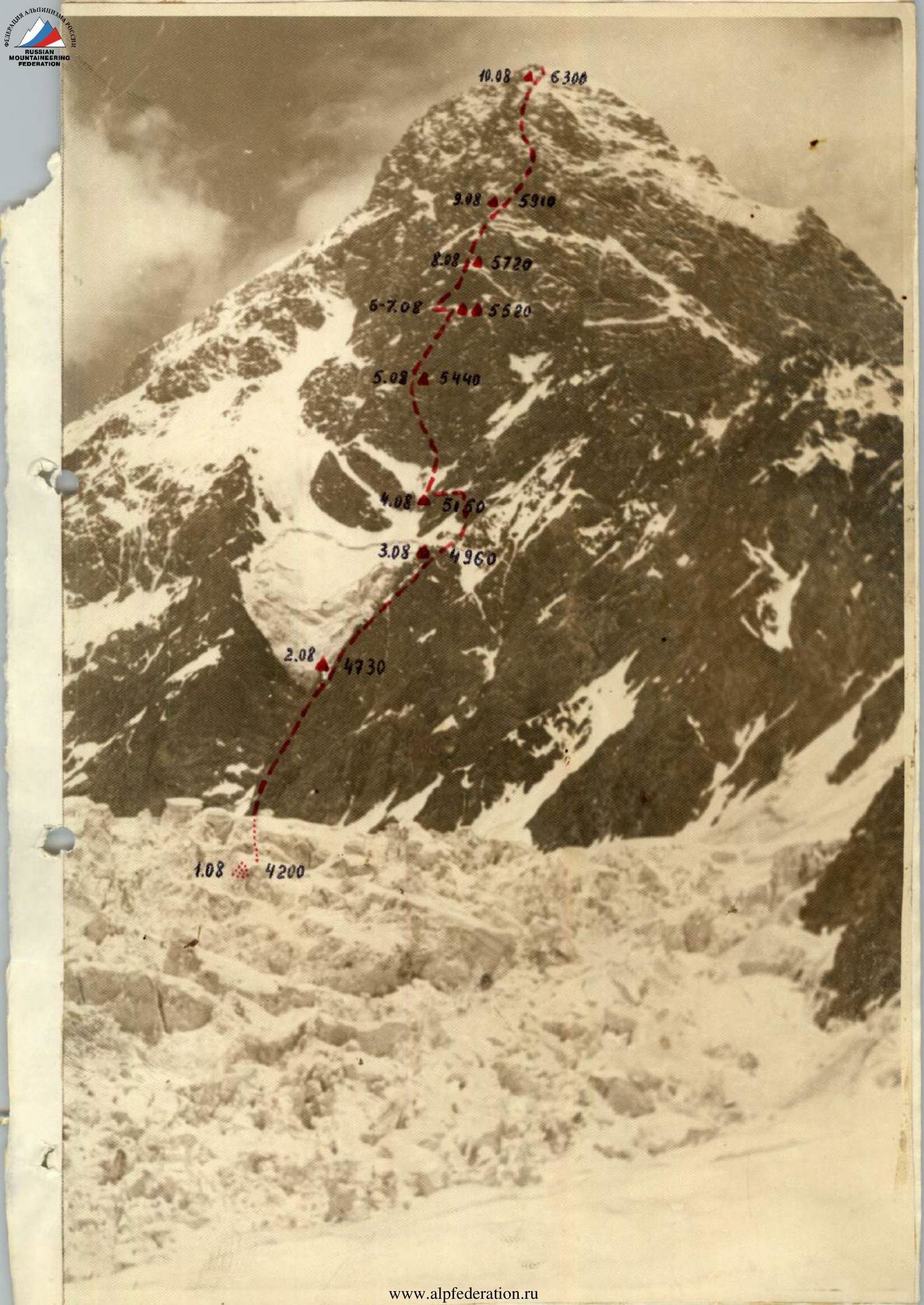
This description serves as an addition to the table of main characteristics of the ascent route and contains information not included in it. Simultaneously, the description includes some questions of ascent tactics, application of technical elements, impressions of the route character, etc. The route is shown on the attached photograph of the peak and profile scheme.
July 31, 1975: after completing their stay at the "Vysotnik" alpine camp, the team with two observation and communication groups left the main base camp at 7:00 along the Geographical Society glacier, following a pre-marked path, and arrived at the 1st base camp, located in a "pocket" of the moraine, on the right side of the glacier's turn, at an altitude of 3400 m, after a 7-hour journey.
August 1: early rise at 5:00. It turned out that one team member could not continue further due to feeling unwell, and Skobelev S.A. returned down with two auxiliary participants, much to everyone's regret.
The rest:
- at 7:00 — departure to the 1st step of the icefall and further along the couloir of the counterfort to the ridge.
- After 3 hours — arrival at the II base camp, where cargo was finally distributed among backpacks, lunch was eaten, and at 12:00, with best wishes from our observers (good weather, good luck), we continued further to the "4200" m plateau under the wall of "Komaakademii".
The weather is good — the sun strongly reflects off the snow, so we had to wear masks. Backpacks are heavy — 20–22 kg!
Having overcome the II step of the icefall via the left upper counterfort along the installed ropes, we exited to the plateau in 2 hours.
Here, we set up a bivouac, and the pair: Ivanov — Drobot, at 15:00, went to process the bergschrund and ice slope under the beginning of the wall. At 18:30, they returned, having installed two 60 m ropes to a rocky outcrop and cut steps in many places with surface ice.
August 2: rise at 6:00, and after 2 hours, we exited under the base of the wall, which began with a destroyed ledge, where the first and last climbers in the rope team removed their crampons.
The rocky work begins, and we can still move with backpacks, but after passing 40 m, slightly to the left of the direction, the steepness is already about 60°, and the sound of hammering pitons is heard. After passing the second rope, we approach an internal corner — very difficult climbing, the first climber goes without a backpack — vertically upwards for 18–20 m. We are still in the shade of the sun. At the end of the exit from the internal corner — a traverse to the right onto a ledge and further along rocks of medium difficulty, we exit onto a wide scree ledge, where there are many "live" stones!
The next rope is passed again through rocks of medium difficulty (see photo № 2) with an exit under a very steep wall. This is the most difficult part of today's climb, and we all go without backpacks — first through a нависающий section (see photo № 3) about 6–7 m, with a traverse to the right along difficult rocks (see photo № 4) with careful piton insurance — and again under a vertical wall 8–10 m, with an exit onto a scree ledge (see photo № 5).
Again, we had to remove our backpacks and pull them up. Along this ledge, first to the left, then along the ridge to the right and upwards, there are many "live" stones (see photo № 6) — we have to be very cautious.
Now the sun is mercilessly "roasting" us, and the dry rocks around us make us thirsty.
The ridge leads us to a wide internal corner, having overcome which, we approach another wall (50 m). Again, we go without backpacks. The wall ends with a sharp ridge, on which there is a large snow snowslide.
It's already 16:30, and this is the best spot for a bivouac — we cut down the snowy ridge, almost the height of the tent (see photo № 7), which takes about 1.5 hours of work, and we establish radio communication with observers (see photo № 8).
For the day, we passed 7 ropes (60 m each), two of which were through very difficult rocks, and 34 pitons were hammered, mainly channel and wide, thickened (all titanium). At this location, we establish the 1st control turret.
4. Composition of the assault group
| № | Surname | Name | Patronymic | Year of birth | Sport rank | DSO | Best ascents and year of completion | Address |
|---|---|---|---|---|---|---|---|---|
| 1. | SHAMAEV | IVAN | ANDREEVICH | 1942 | CMS | «Spartak» | peak "Krumkol" 6 cat. sl. in 1972; peak "Kommunizma" 5B in 1973; "Ushba" with S.-Z. 6 cat. sl. 1974 | Tyrnyauz, Elbrus prospect № 87-a, apt. 10 |
| 2. | DROBOT | STANISLAV | YURIEVICH | 1944 | CMS | – | peak "Krumkol" 6 cat. sl. in 1972; v. "Chegettauchana" 5A 1973; "Ushba" with S.-Z. 6 cat. sl. 1974 | Tyrnyauz, st. Kalinin № 6, apt. 13 |
| 3. | KARLOV | ANATOLY | IVANOVICH | 1950 | CMS | – | v. "Ullugaushana" with S. 5B cat. sl. in 1973; v. "Dzhaiklyk" Gorky route 5B cat. sl. in 1974; "Ushba" with S.-Z. 6 cat. sl. 1974 | Tyrnyauz, st. Mira № 7, apt. 2 |
| 4. | IVANOV | YURY | ANDREEVICH | 1935 | CMS | – | p. "Shchurovsky" via Kensitsky 5B cat. sl. in 1971; v. "Dalar" via Z. wall 5B and v. "Ullugaushana" with S. 5B in 1973; v. "Tikhtengen" via S.-V. wall 5B cat. sl. in 1974 | Nalchik, st. Ostrovsky № 49 |
| 5. | POROKHNYA | YURY | IVANOVICH | 1932 | MS | – | peak "Tadzhikistan" 6 cat. sl. 1966; v. "Chatyntau" with S. 6 cat. sl. 1969; p. "Krumkol" 6 cat. sl. in 1972; "Krest Ushby" 5B 1974 | Nalchik, st. Kirova № 12, apt. 50 |
The rest of the translation continues here.
3 August: the weather worsened overnight, and we were enveloped in clouds; only near peak Garmo were "windows" visible — "cirrus" clouds floated above the mountains. We decided to start climbing anyway after checking in with the observers at 9:30.
Directly from the bivouac, we climbed the first rope up the internal corner filled with snow to the destroyed rocks, then straight up and left onto the ridge with sharp "gendarmerie" that were mostly climbed "head-on".
It was hard to climb due to deep snow. The ridge led us under the "yellow" wall, about 80 m, 60–65° with monolithic rocks. After overcoming it, we again exited onto a sharp ridge with cornices. The weather remained poor — wind, occasional "graupel" snow. We couldn't see a suitable bivouac site, so around 15:00, we decided to cut down a cornice, which took about 3 hours of work, but allowed us to sleep at full length.
For this not very difficult day compared to the previous one, we covered only 4.5 ropes and hammered 22 pitons.
4 August: today is a very responsible day — we need to reach the base of the "black triangle", crossing rocky-ice couloirs. We started early at 7:30, although the weather wasn't favorable — wind was blowing clouds. When crossing the couloirs at 60–75°, we paid special attention to both insurance and observation of possible rockfalls from above. The first and last climbers in the rope team wore crampons, partly cutting steps in the ice, and sometimes encountered firm snow (see photo № 9).
By 16:00, we finally reached the base of the wall; naturally, we didn't expect to find a suitable bivouac site — it took us a full 2 hours to set it up — it ended up being a semi-reclined position.
The weather worsened sharply: wind, snow, visibility up to 100 m. We covered a total of 5 ropes for the day, which is about 300 m in length, and gained almost half that height vertically. We hammered 32 pitons. On this bivouac, we established the 2nd control turret.
5 August: we rose at 6:00 today but didn't start until 10:00 — getting ready was complicated by the cramped conditions in the tent; it was cold outside! The weather still wasn't in our favor — occasional "graupel" snow fell from above. The wall looked menacing, but the path was well visible — there were snow-covered ledges.
The first 60 m rope passed along a steep ice slope at 60°, then along a rocky wall "head-on" — Karlov climbed (see photo № 10) using ladders, with a steepness of up to 85°.
This continued throughout the day — walls, pulling up backpacks (see photo № 11), again ledges (see photo № 12) and little walls, the sound of pitons, and voices: "Ready?", "Yes, go!"
The lead climbers took turns — I. Shamaev went next, followed by Yu. Porokhnya. The effect of altitude was felt (we were at around 5300–5400 m above sea level), especially when pulling up backpacks.
By the end of the day at 18:00, we found a "snowy patch" under one of the walls and set up the tent (see photo № 13). Here, we established the 3rd control point.
For the day, we completed about 5.5 ropes of difficult climbing, mostly without breaks, and hammered 39 pitons (some with ladder installation).
Communication with the observation groups was very good — this reassured us.
6 August: we rose late today because we had to spend a lot of time setting up the bivouac and preparing dinner the day before — we didn't leave until 10:30. There were breaks in the clouds in the morning, although the heavily clouded peak Garmo indicated that the weather wouldn't improve.
Immediately from the bivouac, I. Shamaev climbed difficult rocks again (see photo № 14) — the rocks were smoothed, crevices were filled with ice, and icicles hung everywhere — the rope slowly climbed upwards. Finally, he reached a narrow ledge — two more climbers joined him — we started pulling up backpacks. Next, Yu. Porokhnya laid the second rope between two нависающий rock ledges (see photo № 15), followed by A. Karlov (see photo № 16). The wind picked up again, and we were enveloped in clouds — it started snowing! We clearly weren't lucky with the weather, but we had to look for a suitable ledge: soon there should be a wide one.
Yes! Finally, by 17:00, we reached it — we could stand comfortably on it, but there wasn't a flat spot for the tent — it ended up being a semi-reclined position (see photo № 17). The photo was taken on the morning of August 8, and on that day, we covered only about 100 m (21 pitons).
The weather worsened completely at night — we almost didn't sleep — we had to hold the tent in place with our body weight at the corners — it felt like we were about to be thrown off!
7 August: bad weather continues — wind, snow. After a difficult night, we rested a bit, dozed off. We weren't bored — observers kept us updated via radio, read out a telegram from Nalchik wishing us a successful ascent and good weather (there was loud laughter in the tent!) and... a loud HURRAY!!! — Yu.I. Porokhnya became a grandfather — a grandson was born.
We requested a weather forecast — KSP informed us that improvement was expected — our mood immediately improved, and we weren't bored with the radio receiver ("Selga"); the предусмотрительный S. Drobot even brought crossword clippings from "Ogonyok"!
By evening, the clouds began to clear, and it got very cold — which meant the weather was:
- improving;
- getting colder.
8 August 1975: we rose at 6:00 and left at 9:00. Initially, we moved along a ledge to the left, then along snows of medium steepness (see photo № 18) — 40 m.
The second rope was laid by A. Karlov — difficult climbing (see photo № 19) vertically upwards; the next 60 m passed along an internal corner with surface ice on the left, and here too, we pulled up backpacks (see photo № 20); the last climber ascended using stirrups with clamps.
The third rope was laid along a wall dissected by ice crevasses (see photo № 21):
- the first climber went without a backpack;
- the rest, although it was hard, climbed along the ropes with backpacks.
This zone led us to a destroyed ledge (see photo № 22) with a traverse to the right and further along a destroyed ridge to the mouth of an ice couloir.
It was already around 18:00; further on, there was a very steep and complex wall — we had no choice but to cut out a platform in the ice, which took practically 2.5 hours, and in the rays of the setting sun (see photo № 23), we finished the difficult work.
For the day, we ascended vertically by only 200 m. The altitude was already around 5700 m. At night, breathing was harder, and the bivouac platform turned out to be semi-sitting.
9 August: we finished dinner and tea late the night before — around 12:00, so we woke up around 8:00 and left at 11:30.
Immediately:
- the first meters were climbed using ladders (see photo № 24);
- further — into the upper part of the couloir (see photo № 25) with an exit to a destroyed ledge.
The second rope went along rocks of medium difficulty (see photo № 26) with a traverse directly to the ridge, which led under a snow-covered wall. The main difficulty here was climbing.
S. Drobot and A. Karlov worked ahead today.
The third rope — we traversed to an ice groove (see photo № 27) and exited along a rocky ridge to a snowy slope; here was the fourth rope for today, which ended on a scree ledge where we could set up a good bivouac site, which we did, as it was already 18:00.
We leveled the site and set up the tent — finally, we would sleep at full length tonight! From this location, we could see and observe another steep wall and further along the ridge, apparently leading to the peak — so, there wasn't much left, and we had passed the most difficult part of the "black triangle". We didn't make much progress today, almost as much as yesterday, and hammered 40 pitons. The weather was variable — wind, often covered by clouds, cold.
10 August: it was very cold at night; the tent ceiling was covered with a thick layer of frost from our exhaled air; boots were frozen, and there was frost inside. We gathered and left at 10:00. The route passed through the following sections:
- The first rope — along rocks of medium difficulty to a snowy patch;
- The second rope — along steep rocks upwards to a scree ledge and an internal corner;
- Along the internal corner (40 m), I. Shamaev climbed first using ladders (see photo № 28);
- The corner ended with a wide chimney (see photo № 29) with an exit to the pre-summit ridge.
Along this ridge, which alternated with rocky sections with deep and loose snow (see photo № 30), we laid 4 ropes, i.e., about 250 m. The ridge led to a rocky wall about half a rope long, and along it (see photo № 31), we exited to a snowy "mulde" at 18:30.
Here, we decided to set up the tent — this was the first bivouac site where we could walk around (with insurance, of course) a few meters back and forth. The weather was sunny today, but not hot — we climbed in down jackets or wearing two sweaters. For the day, we covered a significant distance: almost 460 m along the ropes! We hammered 52 pitons.
11 August: the night was restless — dry air and thirst tormented everyone, and headaches were also a problem — the altitude was already 6300 m! We woke up around 7:00, scraped the frost off the tent again, warmed our boots over a primus stove, had breakfast, and left at 9:30 to storm the peak. Having climbed up a firm snowfield for just over a rope, we reached the peak dome (see photo № 32) — finally! We removed a note from the CSKA team dated August 24, 1973, and left our own (see photo № 33). The panorama around us was magnificent! We admired the grandiose "river" — the Fedchenko glacier. The weather was excellent today! Around us, as far as the eye could see, were mountains, mountains... and how many unconquered peaks were there?!
But we had to continue our path along the jagged rocky ridge with sharp changes in altitude to the North peak. This path took us a whole day (see photos № 34, 35).
We stopped at 15:00 in a "mulde" on the southeast ridge leading to the North peak. The sun was mercilessly hot, and we were thirsty. We lit a primus stove, made tea, and the pair S. Drobot — Yu. Ivanov went further to process the ridge. After 2 hours, they returned, having installed 2 ropes. Radio communication with observers wasn't possible — we were blocked by the ridge, but we managed to contact the "Zenit" team, which was attempting the West face of the North peak — they informed our observers that everything was fine with us.
12 August: the night was again poor — headaches persisted, and we were still thirsty. We got up early to have the lead climber reach the North peak in time for the 9:30 radio check. We climbed the North peak using the prepared ropes (see photo № 36), left our note, and inserted a badge and pin with images of Kabardino-Balkaria. Then, we descended via the 5A category route to the "5500" m saddle (see photo № 37).
This path took us a full working day, using rappelling and sports climbing techniques. We had to be especially cautious when descending from the "5500" m saddle along a rocky counterfort with many "live" stones and further to the bergschrund along an ice slope (first and last climbers wore crampons).
By 19:30, we descended to the plateau to the "Zenit" team's bivouac, where they warmly welcomed us and treated us to a hot dinner.
13 August: today, we could afford to sleep in a bit longer. We left the bivouac at 12:00. After a 2-hour journey across the plateau, under the shadow of both peaks of "Komaakademii", we descended to a rocky shoulder of the II base camp to our observers. Congratulations, hugs...! We took a memorable photo in front of the peaks (see photo № 38).
After lunch:
- we dismantled the base camp;
- descended down to the II base camp ("pocket"), where the second group of assistants was waiting with impatience — here, we were congratulated on the successful completion of the ascent.
The grass was already visible — it smelled of flowers, and we were each given small bouquets.
14 August: the morning was beautiful — sun, silence! We distributed our equipment and remaining food among our backpacks and left at 11:00. We traversed the last path along the Geographical Society glacier, which was well familiar to us, and arrived at the "Vysotnik" base camp at 17:00, where we were given a grand welcome by the participants of the 2nd shift and KSP staff, who presented us with a traditional watermelon and Asian melon! Now, we could say that the ascent was completed successfully.
15 August: today, we conducted a debriefing in the presence of a judge, the head of the training department of the "Vysotnik" alpine camp, KHEYSIN L.E., the head of the KSP of the Vanch region, Comrade OVCHAROV G.N., the instructor of the KSP — CHEKANOV G.A., the head of the rescue team of the "Vysotnik" alpine camp, GUTMAN A.R., the senior instructor of the discharge climbers' gathering of the Krasnodar DSO "Burevestnik", KISELEV S.Y., the leader of the gatherings of the Leningrad DSO "Trud", KOLCHIN A.Z. (who arrived a bit later), and all team members.
On the same day, we prepared for departure: packed cargo into boxes, distributed equipment among backpacks, etc.
We left for Osh only on August 18, as the last two days were spent restoring a bridge across the Abdukagor river and pulling a ZIL-130 truck (camp vehicle) out of the Vanch river near the village of Poi-Mazar.
6. Evaluation of the team's actions
The team successfully accomplished the task set before it by making an ascent to one of the most beautiful and complex peaks of the Central Pamir within the framework of the USSR championship in the class of high-altitude and technical ascents via a new route, passing through the center of the Southwest face between the routes of Bitny and Matyushin — the highest (presumably) category of difficulty.
Each team member was technically well-prepared, and excellent physical fitness allowed them to complete the route at a normal pace without any deviations from the planned days for passing the wall in the original plan.
During the ascent, all team members were evenly loaded with work, both in laying the path first and in extracting pitons last. In addition, the lead climber's backpack was lighter compared to the others. However, it is worth noting that A. KARLOV, I. SHAMAEV, and Yu. POROKHNYA worked ahead most of the time.
The other two team members, S. DROBOT and Yu. IVANOV, made a significant contribution to the passage of the route, especially when extracting pitons and pulling up backpacks.
Particular attention was paid by everyone to insurance and self-insurance throughout the route; they didn't relax until the end of the ascent and monitored each other mutually to ensure safety. The relationships among team members were friendly, formed during joint ascents in previous years; each member showed their best character traits and moral-volitional preparation with full responsibility before the collective and the alpinist community of Kabardino-Balkaria.
Despite the fact that four out of five team members are Candidate Masters of Sports, they all had previous experience with complex ascents in the Caucasus and are champions of the Central Council of the "Spartak" Sports Society in the class of technically complex ascents for 1972 and 1974.
7. Data on the rescue group and observation group
The first group of the rescue team and direct observation from the II base camp consisted of first-class climbers with the right to ascend via a 5B category route and could provide assistance to the team at any moment. Several options were considered for this group to reach the route of the team's first ascent:
- either to the saddle of the south ridge and further along it (partially via Bitny's path) to the upper part of the "black triangle";
- or via Nekrasov's route to ascend to the saddle between the North and South peaks of "Komaakademii" and provide assistance depending on the location of the incident.
This group included an alpinist with paramedic qualifications who could provide effective first aid until a doctor arrived.
The second observation and communication group from the 1st base camp consisted of second-class climbers with the right to ascend via a 4B category