Ascent Log
I. Ascent Category. High-altitude and technical.
-
Ascent Region. Central and North-Western Pamir.
-
Ascent Route. Komakademii Peak, 6439 m, Western wall, Northern summit.
-
Ascent Characteristics.
Height difference 1840 m, average steepness (wall) 72°, length of complex sections 1460 m.
- Pitons driven:
Rock - 159, ice - 67 (42 of which in rock), expansion - 2.
-
Number of man-hours - 71.
-
Number of nights and their characteristics - 5.
1st - sitting on a scree shelf, 2nd - sitting on an inclined shelf, 3rd and 4th - sitting; inclined ice-rock shelf, 5th - normal on the pre-summit dome; snow.
-
Team Name. Team of the Moscow Regional Committee for FIS under the Moscow Regional Council of Deputies.
-
Surname, name, patronymic of the team leader, participants, their qualification. Leader
Zhurzdin Vladimir Iosifovich - CMS, Gladchenko Vladimir - CMS, Ivanchin Ivan Andreevich - CMS, Kuzmin Anatoly Sergeevich - CMS, Makhonovich Leonid Alexandrovich - CMS, Prokopenko Valery Mikhailovich - CMS.
- Team Coach. Penchuk Valentin Lavrentievich - MS.
II. Date of departure on the route and return
August 3 - August 15, 1975.
- p. Komakademii North summit 6439 m

 |
|---|
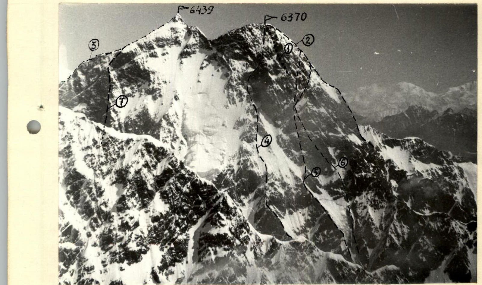
Fig. 1. Peak Kommunisticheskoy Akademii (view from p. 5933)
Laid Routes
-
Along the NE-SW ridge - A. Pyankov, 1965, team of Uzbekistan
-
Along the 15 wall - A. Bitny, 1971, Armed Forces
-
Along the NW ridge - I. Bandurovsky, 1972, Armed Forces
-
Along the SW wall, then traverse to p. Garmo - V. Nekrasov, 1972, Armed Forces
-
Along the SW wall - L. Matyushin, 1972, Armed Forces
-
Along the SW wall - Yu. Porokhnya, 1975, Kabardino-Balkaria
-
Along the 3 wall - V. Zhurzdin, 1975, Moscow Region
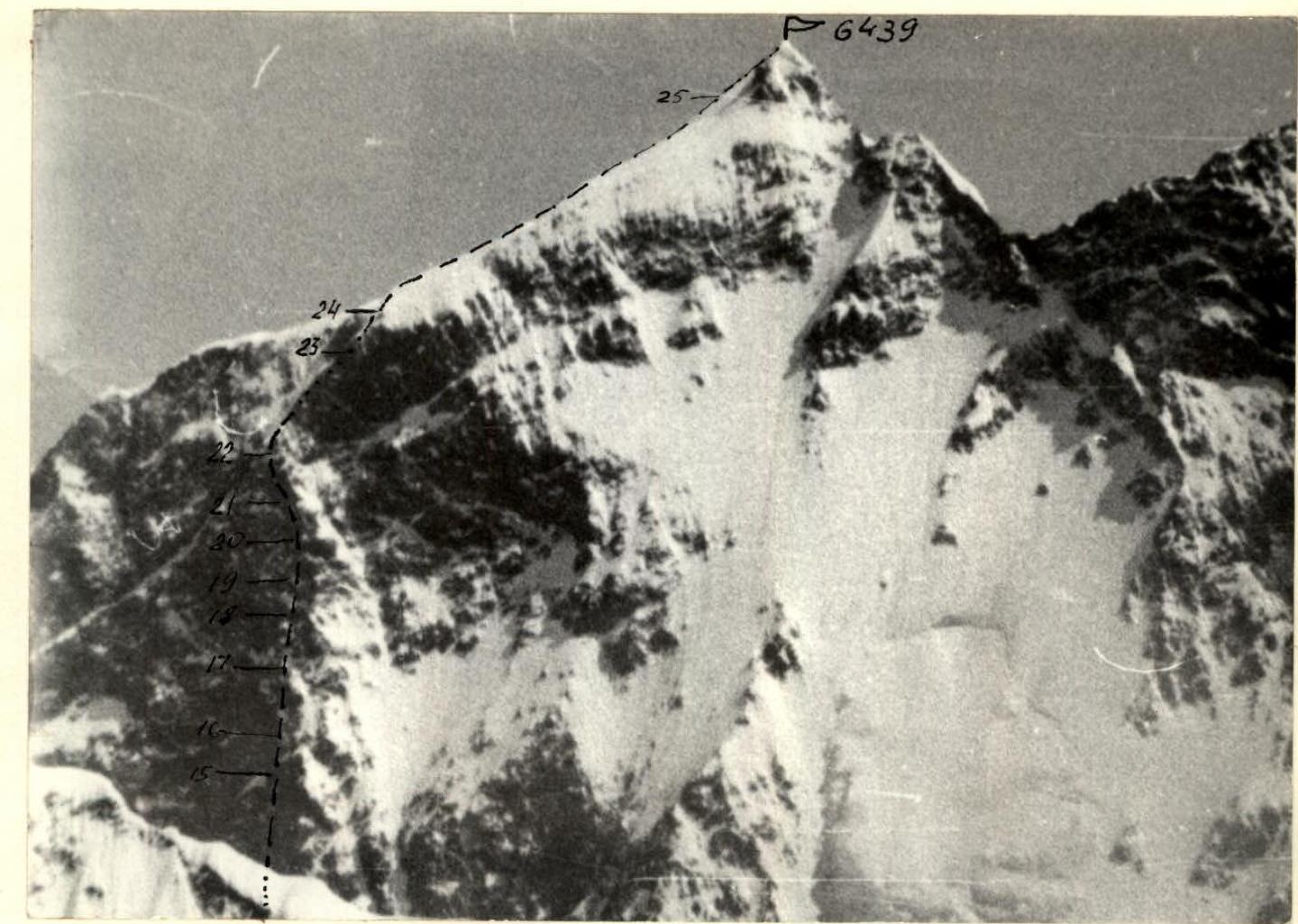
Fig. 2. Northern summit of Kommunisticheskoy Akademii (view from p. 5933, telephoto lens)
Route Clarification and Tactical Plan
The entire Western wall of Komakademii appears to us as a triangle, with the lateral sides being the NW ridge on the left and the Western counterfort on the right, beyond which the SW wall of the peak begins. Our goal is the vertex of this triangle, and we need to reach it along the height of the triangle. This is the "geometric" task before us. The option of ascending along the Western counterfort was also discussed, but as a less complex one, it remained in reserve.
To the right and left of the route, the wall is cut by vertical couloirs for more than half its height, collecting all the stones, avalanches, and ice fragments falling from the walls as a result of thawing.
The complex and lengthy route, starting at an altitude of 4600 m, required us to develop a careful tactical ascent plan, the main points of which are given below:
- Breaking down the route into sections according to complexity
- Determining the points for setting up bivouac camps
- Planning the ascent schedule taking into account weather conditions
- Preparing oxygen supplies and equipment for each stage
- Organizing a communication system between team members
The team composition was determined to be 6 people, as the most mobile and agile group for a high-altitude wall. The team included the most physically and technically prepared members at the time of the ascent.
The equipment and food were carefully selected to ensure the team's safe existence on the wall while minimizing weight. In particular, the team pooled all their down equipment, reducing its weight by 6 kg. High-calorie food, lightweight cooking equipment, titanium crampons, and other measures allowed them to have an initial backpack weight of around 16 kg.
Based on the information obtained, the route sheet planned 16 days for approaches, processing, and observing the wall, working on the wall, and descending to the base camp, with a 4-day reserve in case of bad weather. The following ascent plan was supposed to be implemented:
- From morning until 15:00-16:00, the group ascends along the section processed the day before, backpacks are pulled up on steep sections, and ice pitons are used predominantly for main anchoring points on rocks;
- From 15:00 to 16:00, the group sets up a bivouac, and one rope team continues processing the wall for the group's progress the next day;
- The group's retreat is only possible along the ascent route, and in the upper part of the route - along the NW ridge.
The responsibilities of team members at the start were defined as follows:
- V. Zhurzdin, V. Gladchenko, V. Prokopenko - leaders;
- I. Ivanchin and A. Kuzmin - rear guard;
- L. Makhonovich - organization of rope team interaction.
During the ascent, minor adjustments were made to the planned plan: the complexity of the section after the third bivouac (overhanging wall) and the large length of the previous section led to the third day of ascent lasting until 21:00 for the entire team, and the team processed the upper part of the wall and bivouacked again on the 3rd bivouac. The physical condition of team members allowed them to climb some complex sections with backpacks without pulling them up, significantly reducing travel time.
The team maintained regular radio contact with observers who were in direct visibility throughout the ascent. The composition of the observation group is given in a separate log, a copy of which is included in this report.
Fig.
7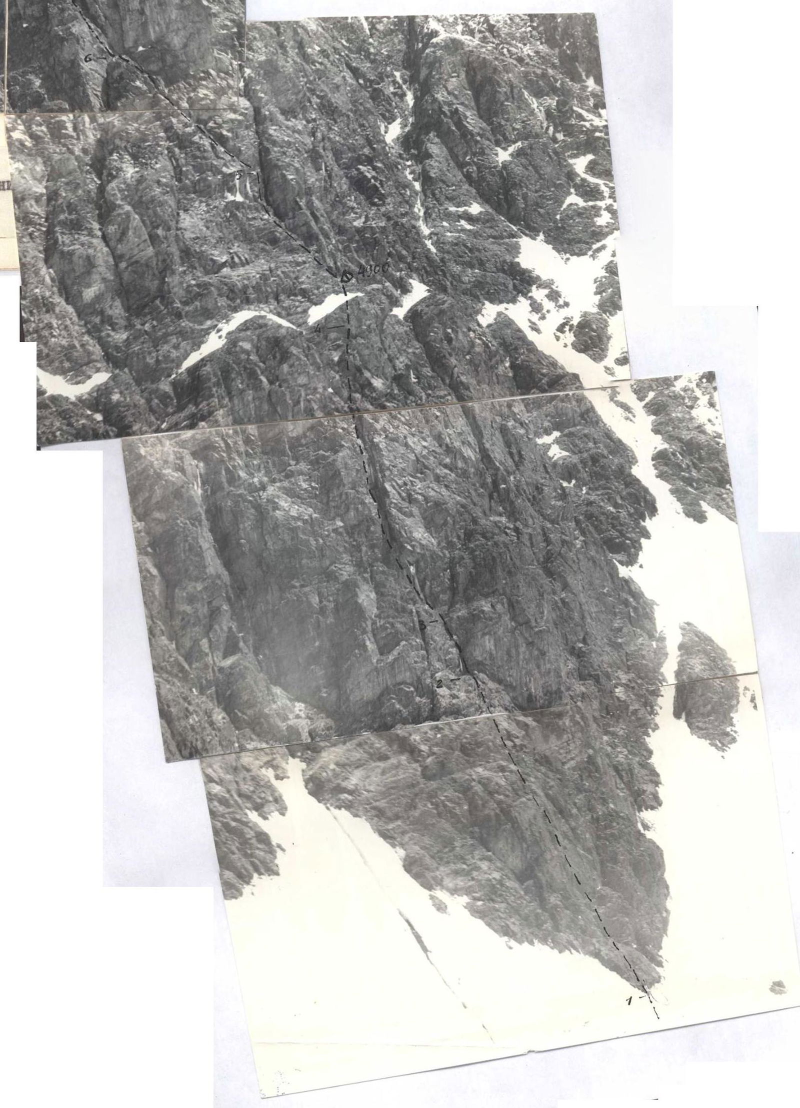
The group's safety was ensured by a rescue team consisting of team members and additional personnel. The team and observers had radio contact with the Kabardino-Balkaria team and their observers, who relayed information to the base camp.
Description of Route Passage
August 3. At 6:00, the team, fully prepared, left the base camp and began ascending along the RGO glacier to the start of the route. At 19:00, the group stopped for a bivouac after the 2nd step of the glacier on the "4200 m plateau" under the SW wall of Komakademii, where the Kabardino-Balkaria team had started their route the day before. Here, in our previous ascents, an intermediate camp was set up, so despite the glacial conditions, the team rested well.
August 4. At 9:00, the group left the intermediate camp on the 4200 m plateau and at 16:00, having overcome the 3rd step of the RGO glacier, approached the start of the route on the 4600 m plateau. We continue to observe the wall and prepare for tomorrow's output of a double team to process the start of the route.
It should be noted that the approach path to the Western wall of Komakademii is very complex:
- The length of the path from the base camp is more than 25 km.
- The height gain is about 2 km.
- The technical complexity of overcoming the three heavily broken glacier steps is much higher than that of the Dykhsu glacier steps.
August 5. At 9:00, the Zhurzdin-Prokopenko duo sets out to process the bergschrund, ice slope, and rocks of the route.
- The 3-meter wall of the bergschrund is overcome with the help of two ice axes driven into the firm frozen firn of the wall, two ladders hung on the driven ice axes, and V. Prokopenko's shoulders, on which they stand to reach the top of the wall.
- From the bergschrund to the rocks - an ice slope 70 m, 50°.
- After putting on crampons and driving 6 ice pitons, the duo overcomes this section (R1) and approaches the rocks.
The rocks are made of large-block rocks with rare granite slabs. Climbing is complex but familiar.
- The first 100 m (75°) are overcome by free climbing (R2).
- The most suitable are shortened (70-80 mm) pitons.
- The upper end of the rope is secured to an ice piton driven into the rocks.
A internal angle goes straight up, ending 10 m above with an overhanging plug (R3).
- The right wall of the angle is covered with ice.
- The left wall is a smooth, overhanging (95°) slab.
Without artificial support, it's not possible to overcome. A ladder is prepared.
- Using a driven piton as a handhold and then a foothold, they manage to reach a crack under the plug.
- A new piton is driven, and a ladder is hung.
- Pulling themselves up on their hands to the edge of the plug, the obstacle is overcome.
From the plug, the angle goes to the right, and straight above is an 8-10 m wall (100°).
- 2 meters from its top, a narrow shelf is visible.
- It's decided to go to the right along the angle for 8 m and organize a "pendulum" onto the shelf.
- The decision is correct - the wall is overcome.
- Above the wall, pitons are driven for pulling up backpacks.
Next is a rock section with a steepness of up to 80° along unclear external and internal angles - 90 m, overcome by free climbing to a vertical internal angle (18 m) with "live" stones at the exit (R4).
- The angle ends with an inclined scree shelf going to the right to the couloir.
- Carefully crossing the shelf, the duo exits onto a pile of large-block walls (R5), steeply (75°) going up to the right (70 m) to an inclined oblique shelf, partially covered with ice and going up to the left (70°).
- The last rope is secured before the shelf.
You can rest and start descending. The day confirmed the correctness and safety of the route from rockfall, despite the fact that on both sides, falling stones and ice fragments were thundering all day. Thanks to the prolonged sunny illumination of the walls, work is carried out until late evening.
- Starting the descent at 18:00, the duo was back at the bivouac in 2 hours and 30 minutes, where they were awaited by a delicious dinner and hot tea.
- The team maintained radio contact with the duo throughout the day.
August 6. The team's departure on the route is possible, but according to the tactical plan, it's a day for processing and observation. Observers have not yet arrived.
- At 8:30, the Gladchenko-Kuzmin duo sets out to the wall with the task of scouting the location of the first bivouac and processing the rope path upwards.
- After 4.5 hours, the duo approaches the top of the processed part of the route.
- A short rest - and back to work.
The exit to the oblique shelf is difficult - one of the sides of a huge internal angle, twisting like a screw to the left and up (R6).
- The angle is covered with ice, which in places creeps onto the shelf, complicating climbing.
- After 20 m, the angle becomes vertical, and the shelf "stands on its toes" - the wall of the angle.
- The ropes go up slowly, but climbing is free.
- Both ice and rock pitons are used.
After 90 m, the duo approaches the upper part of the angle.
- Here, a wide (2.5 m) smooth slab, slightly concave in the center, goes up 50 m (75° at the bottom, 90-95° in the upper 15 m) - called the "trough" (R7).
- From here, the duo begins its descent.
The only possible place for the first bivouac is the scree shelf (R5) in its right part.
- At 21:00, the duo returns to the bivouac, where observers A. Krutykh and A. Arkhireev arrived an hour earlier.
August 7. Until 14:00 - bad weather: fog, snow. Cleared up by evening. The team rested well and is ready for the assault.
August 8. At 6:30, the team sets out on the route. Very cold, but remembering the safety of passing the ice slope from the bergschrund to the rocks early in the morning.
- The group clearly and quickly overcomes the ice slope.
- An extra rope is thrown down - it will be picked up by observers.
- The ascent begins along the processed sections.
- At 16:00, the last participant approaches the bivouac site - the organization of the night's stay begins.
- "Extra" stones from the scree shelf fly down - "construction" is underway.
The Zhurzdin-Prokopenko duo, equipped like rock climbers, goes up to process the "trough" slab (R7).
- Climbing in crampons on the slab is extremely difficult.
- Zhurzdin puts on galoshes and literally on friction passes the first 3 m to a small inclined crack, where a petal hook is driven.
- Another 2 m up on fingertips - the "trough" is split in the center by a small vertical crack.
- It becomes possible to use pitons as supports.
- Another 15 m up - to the left, where the crack shifts.
- The steepness increases to 80°, and at the top, the "trough" seems to tip over on the climber (95°).
- The tension is very high.
To the right, on the edge of the "trough", a small shelf is noticeable, from which a more prominent outer angle runs parallel.
- To the shelf - about 4 m of smooth slab.
- A "pendulum" is organized - and now you can rest on a cozy shelf where both feet fit.
Climbing the outer angle to the top of the "trough" is not much easier, but using one ladder, the duo exits up and along steep (75°, 100 m) slabs and granite blocks (R8) reaches the "gates", beyond which a steep ice-firn terrace begins.
- The duo's task is completed, it's getting dark.
- They return to the bivouac site, where a tolerable platform is laid out by 20:00.
- A tent is set up, one edge of which hangs down.
- Everyone manages to sit inside.
- Everything is secured with a rope.
- A hot dinner is organized.
- Somehow, the group rests.
August 9. A cold but clear morning. A panorama of snowy peaks opens up: Peak Revolyutsii, Peak Parizhskoy Kommuny, and beyond the border - a two-headed peak above 7000 m.
- We have breakfast, and at 7:30, the team heads up.
- At the "trough" slab, the pulling up of backpacks is organized - it goes smoothly and quickly.
The "gates" are formed by two steep (80°) counterforts limiting the ice-firn inclined terrace (55°).
- We pass the "gates", and after 10 m, we turn right onto the rocks of the counterfort.
- Here, we lay out a control cairn.
- Beyond the counterfort and couloir is another counterfort where we can lay out a bivouac.
- We traverse 50 m with a height gain (30 m) (R9) to the second counterfort and mark the bivouac site.
To the right, from above, an ice couloir falls, and ahead, a "gendarme" tower rises, which we need to climb.
- Four start building the bivouac: a narrow (no more than half a meter) shelf is expanded with stones and ice axes to secure the tent.
- The Zhurzdin-Makhonovich duo goes up to process.
To reach the base of the "gendarme" tower, they overcome 30 m of a steep (60°) ice ascent with rock outcrops (R10).
- Three ice pitons and crampons help overcome the ascent and exit onto the rocky bank of the couloir (R11).
The R11 section (25 m, 75°) is psychologically challenging:
- Down to the base of the wall, a couloir descends.
- Movements are cautious, elongated pitons are used.
The section ends with an overhanging (95%) 6-meter wall leading left from the couloir.
- The wall is overcome with the help of two ladders and pulling up.
- It leads to a 15-meter scree shelf (60°) - the top of the "gendarme".
Before us is an ice ascent (40 m), ending with an ice wall (10 m, 55-60%) at the foot of the 2nd tower (R12).
- L. Makhonovich passes first, perfectly.
- He drives 5 pitons, cuts out a dozen steps, reaches the rocky wall of the tower.
- Along it, he traverses to the right (10 m), approaches a narrow gorge of the ice couloir, from which we deviated a little lower.
- Along steep (70°) ice walls of the couloir, we need to cross it and reach a rocky island (20 m).
- This is one of the most difficult places on the route - the ice is natty, very hard.
- Pitons and a series of steps prevent unpleasantness (R12).
Securing the rope, the duo returns to the bivouac and helps finish building the platform.
- Only late in the evening, having secured the tent, we discuss the day's results over dinner and prepare for tomorrow.
- The platform is a bit short, 1.2×1.4 m, despite titanic efforts - we sleep semi-sitting.
August 10. Early rise. At 7:00, the group begins its ascent along the processed sections.
- To the left is Peak Kommunizma.
- Behind us are the ice walls of Peak Garmo.
- To the right are vast ice slopes.
After the processed sections (passed in 4 hours), the path goes along a combined ice-rock ascent (R13-R16) under the upper part of the wall, starting 300 m from us with a vertical 80-100-meter rock bastion.
To the bastion, we overcome:
- An ice-covered rock ascent - the bank of the couloir (50 m, 65°, R13).
- An ice slope (45 m, 50°, R14).
- A destroyed rock island (50 m, 70°, R15).
- A 30-meter ice ascent (50-55°, R16).
The group overcomes the sections according to the scheme:
- Ahead is the Gladchenko-Prokopenko duo.
- The rearguard rope team is Ivanchin-Kuzmin.
- The connecting Zhurzdin-Makhonovich rope team organizes the transfer of removed ropes, pitons, and carabiners.
From 16:00, the group searches for a place under the bivouac, but the relief does not allow choosing a suitable platform.
- Hope is a possible shelf in the upper part of the bastion (R18), where we can secure the tent.
At the foot of the bastion, Zhurzdin goes ahead (leaving his backpack).
The start of the bastion (R17) is a rocky steep (70°) 45-meter ascent, climbing is complex but free.
- The ascent ends with a 4-meter overhanging (100°) wall, turning into a 25-meter vertical slab (R18).
- The wall is covered with ice from water flowing from above.
- Part of the ice is knocked off with an ice axe and a hammer.
- A ladder is hung.
- With its help, we manage to climb onto a barely noticeable ledge at the bottom of the slab.
- A crack going up the slab to the left allows us, with the help of pitons (for insurance and support), to reach the top of the slab, ending with an inclined scree shelf.
The shelf encircles the bastion (15 m from the top) from left to right to a vertical internal angle, slightly below turning into an ice couloir.
- To the right, near the angle, is a small ice ridge; if it's cut down, it seems possible to lay out a platform.
- To secure the rope: it's impossible to drive a piton on the shelf - we resort to expansion pitons, driving two expansion pitons.
- Four more participants climb onto the shelf.
- The pulling up of backpacks begins, then the rearguard.
Two hours of remaining light are spent preparing the bivouac.
- At 22:00, the last participant climbs into the secured tent.
- After dinner, tired but satisfied, we fall asleep in an uncomfortable but warm and protected tent.
August 11. The decision is made to give the team a relative rest:
- Rise at 8:30.
- After breakfast, at 10:00, the Zhurzdin-Ivanchin duo goes out to process the wall.
- The rest prepare for the exit and improve the bivouac (mainly expanding it).
- On one of the expansion pitons, we hang a tin can with a note - the second control cairn.
From the tent, the route goes straight up onto the bastion (15 m, 90°) along rocks, difficult and cold from the morning frost.
- The top of the bastion is an ice-inclined (40°) platform (6×6 m) with embedded stones.
- Above the platform, a wall of the next tower hangs in a semicircle.
- The route should go straight through the center of this wall, where a shallow internal angle passes.
- 15 m above, a small shelf is guessed (R19), from which the angle, deepening into the wall, leads to a less steep part (R20).
We reached the shelf by driving 8 pitons and hanging 3 ladders, with the help of pulling up on the rope.
- Further, the wall first becomes more gentle, up to 70-65° on the first 25 m, then becomes steeper (80°) on the next 30 m (R20).
- The section is overcome by free climbing with piton insurance.
Before the next section - a 10-meter ice slope (50°) of a rock ascent (R21) - we can rest on a 2-meter slab.
- The leader is changed (Ivanchin goes first).
- The duo continues processing.
The rock ascent (70 m, 75°) is an alternation of steep slabs, monolithic blocks, and scree shelves, exiting onto a steep (70°) sharp counterfort (R22).
- Climbing is complex, psychologically tense.
- Special attention is paid to scree shelves: stones can fall off from the touch of a rope.
- Having secured the rope and outlined the path for the next duo to the protruding 100 m rocky "finger", the duo descends to the bivouac by 15:00.
To process the counterfort to the "finger" (R22), the Gladchenko-Prokopenko duo goes up.
- The sharp ridge of the counterfort is especially difficult where it turns into an ice-firn 10-meter knife-edge.
- It was necessary to cut down the ridge, cut out steps, and use ice pitons for support.
- 20 m from the "finger", the rope is secured to an ice piton driven into the rocks.
- You can catch your breath and return.
At 19:00, the duo returns to the tent.
During the evening communication, we are contacted by the Kabardino-Balkaria team "Yu. Porokhnya" with a request to pass on information about their victory to the camp, as their observers cannot hear them. We congratulate the team on their victory, wish them good weather, which is already favoring us, and pass on the information along the chain to our observers. Our mood is upbeat; we feel that the next day may be the last on the wall.
August 12. At 5:30 in the morning, the team sets out upwards. The overhanging wall (R19) is passed without backpacks in the following order: V. Prokopenko, having secured himself on pitons, pulls up someone's backpack onto the shelf, secures it, and then accepts the owner of the backpack. The backpack is taken, and the participant goes up, and the operation is repeated. This was the last section on the wall where backpacks were pulled up. From the "finger", the route represents a steep (on average 70°) weakly expressed counterfort (R23) going up to the right. After 180 m, it ends with an overhanging gendarme, to the right of which a wide (up to 2 m) internal angle, filled with ice, goes steeply up (60-65°), the left wall of which is the wall of the gendarme (R24). The counterfort is passed by the leader, Kuzmin, thus completing the relay of leaders. He passes confidently, with free climbing, although some places are very complex. The 80-meter internal angle, using the left rocky wall for pitons, is first passed by Zhurzdin in crampons. The angle ends with a firn slope with several rocky islands - this is the beginning of the pre-summit dome. At 16:00, the last participant climbs onto the dome. An hour later, we set up a tent in a snow depression on the dome. 250-300 m ahead of us, the rocky summit of Komakademii is visible. It's decided to climb to the summit without backpacks along the firm snow in the morning, and for now - a well-deserved rest in the tent, where finally everyone can stretch their legs. An abundant dinner and a sound sleep.
August 13. At 9:00, the team, leaving the tent and gear, heads along the snow dome (R25) to the main summit of Komakademii. Finally, the rope teams can move simultaneously. After 1.5 hours, we are on the summit. We survey the panorama of the Pamir. From here, all the "giants" of the Pamir are visible, and below, like a frozen river, or rather a wide highway, the Fedchenko Glacier winds its way, rising towards Peak Revolyutsii. The impressions are indelible. We took a note from Yu. Porokhnya's group, took photos, and an hour later began our descent. On this day, having removed the tent, the team descended along the NW ridge of the summit to the saddle between Peak 6045 m and Komakademii, where they spent the night.
August 14. At 12:00, the group descended to their observers and together with them began their descent. At 20:00, the team stopped for a bivouac on rocks above the 1st step of the glacier.
August 15. Having safely overcome all the ice obstacles of the glacier, at 18:00, the team returned to the base camp.
Table of Main Characteristics
Ascent Route: Komakademii Peak, Western wall

| Date | Passed sections | Average steepness | Length | Characteristics of the section and passage conditions | Relief character | Category | Passage method and insurance | Weather conditions | Time of stops: bivouac, exit, man-hours | Pitons driven: rock, ice, expansion | Bivouac conditions |
|---|---|---|---|---|---|---|---|---|---|---|---|
| 1975 | |||||||||||
| August 5 | R1 | 50° | 70 m | Ice slope | 4-5 | Pitons, ice axes, crampons | Good | 18:00, 9:00, 9 h | 6 ice | Normal under the wall, on the glacier | |
| R2 | 75° | 100 m | Rocks of schist and block structure, slabs | 5 | Pitons, free climbing | 12 rock, 2 ice | |||||
| R3 | 95° | 18 m | Overhanging angle and wall. Angle with non-flowing ice | 6 | Pitons, ladders, pendulum, pulling up | 6 rock, 1 ice | |||||
| R4 | 80° | 110 m | Slabs, external and internal angles | 5 | Pitons, free climbing | 6 rock, 6 ice | |||||
| R5 | 75° | 70 m | Large-block walls, slabs | 4-5 | 5 rock, 2 ice | ||||||
| August 6 | R6 | 85° | 90 m | Internal angle with ice | 5 | Pitons, free climbing | Deterioration from 17:00 | 17:30, 13:00, 4.5 h | 8 rock, 2 ice | Same bivouac under the wall | |
| August 7 | Fog, snow, visibility 10 m, wind | ||||||||||
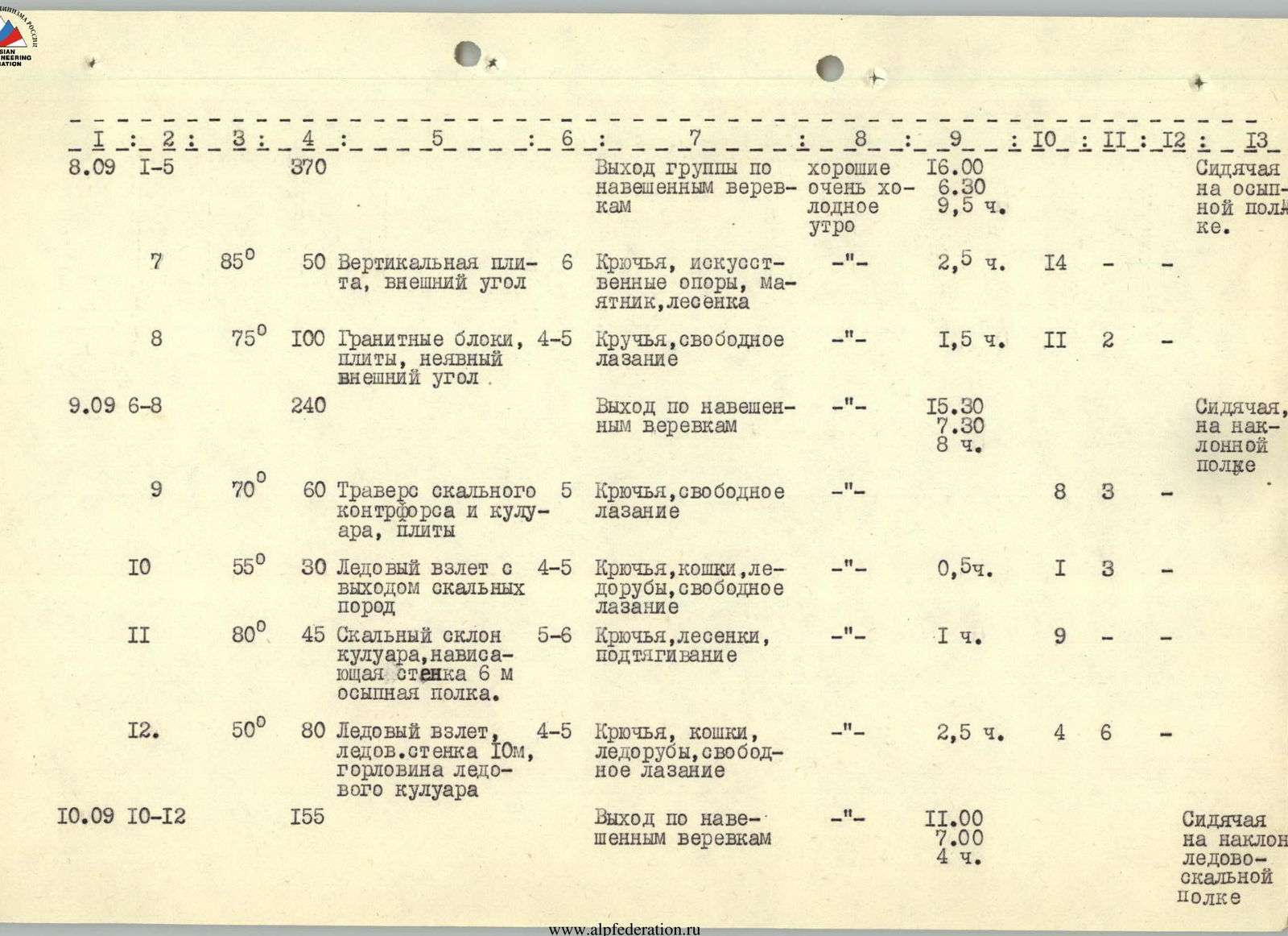
| August 8 | R1-R5 | 370 m | Group's exit along pre-laid ropes | Good, very cold morning | 16:00, 6:30, 9.5 h | Sitting on a scree shelf | |||||
| R7 | 85° | 50 m | Vertical slab, outer angle | 6 | Pitons, artificial supports, pendulum, ladder | 2.5 h | 14 ice | ||||
| R8 | 75° | 100 m | Granite blocks, slabs, unclear outer angle | 4-5 | Pitons, free climbing | 1.5 h | 11 rock, 2 ice | ||||
| August 9 | R6-R8 | 240 m | Exit along pre-laid ropes | 15:30, 7:30, 8 h | Sitting on an inclined shelf | ||||||
| R9 | 70° | 60 m | Traverse of rocky counterfort and couloir, slabs | 5 | Pitons, free climbing | 8 rock, 3 ice | |||||
| R10 | 55° | 30 m | Ice ascent with rock outcrops | 4-5 | Pitons, crampons, ice axes, free climbing | 0.5 h | 1 rock, 3 ice | ||||
| R11 | 80° | 45 m | Rocky slope of couloir, overhanging wall 6 m, scree shelf | 5-6 | Pitons, ladders, pulling up | 1 h | 9 rock | ||||
| R12 | 50° | 80 m | Ice ascent, ice wall 10 m, gorge of ice couloir | 4-5 | Pitons, crampons, ice axes, free climbing | 2.5 h | 4 rock, 6 ice | ||||
| August 10 | R10-R12 | 155 m | Exit along pre-laid ropes | 11:00, 7:00, 4 h | Sitting on an inclined ice-rock shelf | ||||||
| August 11 | R13 | 65° | 50 m | Rocks covered with ice | 5 | Pitons, crampons, free climbing | Good morning - frost | 20:00, 11:00, 9 h | 4 rock, 7 ice | Same bivouac | |
| R14 | 50° | 45 m | Ice slope | 4-5 | Pitons, crampons, ice axes | 4 ice | |||||
| R15 | 70° | 50 m | Slabs, large-block destroyed rocks | 4-5 | Pitons, free climbing | 7 rock | |||||
| R16 | 50° | 30 m | Ice ascent | 4-5 | Pitons, crampons, ice axes | 3 ice | |||||
| R17 | 70° | 45 m | Slabs, internal angle | 5 | Pitons, free climbing | 2 rock, 4 ice | |||||
| R18 | 85° | 50 m | Overhanging wall 4 m, slab, narrow scree shelf, outer angle | 6 | Pitons, ladders, pulling up, artificial support points | 14 rock, 2 ice | |||||
| R19 | 105° | 15 m | Overhanging wall, shallow internal angle | 6 | Pitons, ladders, pulling up | 19:00, 10:00, 9 h | 8 rock | ||||
| R20 | 75° | 55 m | Schist rocks, slabs, large-block rocks | 5 | Pitons, free climbing | 11 rock, 1 ice | |||||
| R21 | 70° | 80 m | Slabs, external and internal angles, sharp rocky ridge | 5 | 6 rock, 1 ice | ||||||
| R22 | 70° | 90 m | Ridge of steep counterfort, scree shelves, ice-firn ridge-blade | 5 | 9 rock, 2 ice | ||||||
| August 12 | R19-R22 | 240 m | Exit along pre-laid ropes | 16:00, 5:30, 10.5 h | Normal on the pre-summit dome | ||||||
| August 13 | R23 | 70° | 180 m | Weakly expressed narrow counterfort. Schist rocks | 5 | Pitons, free climbing | Good | 9 rock, |