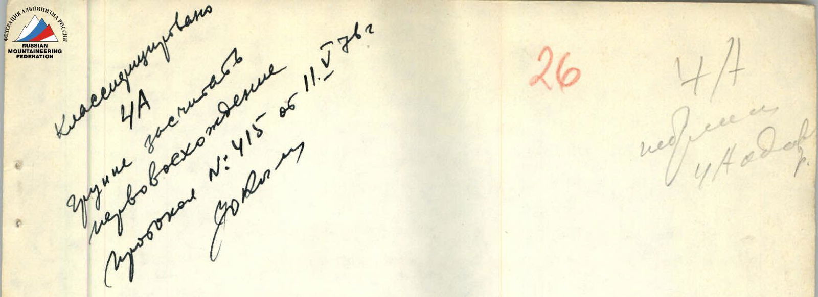
NORTHWESTERN PAMIR I Eastern Kovshovykh Peak (Northern peak)
5800 m
via the left edge of the western wall (orientation 5A cat. difficulty, combined) (FIRST ASCENT)
- SHARONOV B.P. — 1st category
- KHRUSTALEV L.N. — 1st category
- KHIZHNYAK V.N. — 2nd category
" Vysotnik" alpine camp
Geographical Characteristics of the Region
Kovshovykh Peak is located in the mountains of Northwestern Pamir. The Kovshovykh Peak massif marks the end of the northern spur (between Yazgulem Pass and Abdukagor II Pass) of the Yazgulem Ridge. The Kovshovykh Peak massif is horseshoe-shaped, situated on Abdukagor II Pass, and is concave towards Fedchenko Glacier. The Kovshovykh Peak massif consists of five peaks:
- The highest point of the massif is 5858 m
- The height of the northern peak is 5800 m
This region is characterized by:
- Extensive glaciation
- Diverse rock relief (featuring both ridge and wall routes)
- Heavy snow cover
- Low temperatures
- Strong winds and frosts
- Snowfalls
This set of climatic conditions is what climbers face when attempting to ascend in this region.
Ascent Conditions, Approach to the Start of the Ascent Route
Abdukagor II Pass, from which the group started their route, is 2-3 days' journey from the base camp of "Vysotnik" alpine camp, located on the moraine of Geographical Society Glacier (18-22 hours of travel).
Currently, due to the increased activity of Medvezhiy Glacier, the possibility of using donkeys for transporting goods is highly uncertain.
The path to Kovshovykh Peak from the moraine of Geographical Society Glacier initially follows a road to the geologists' settlement, located at the right (orographic) edge of Medvezhiy Glacier tongue (4 km).
Then, from the settlement, ascend 300-400 m along the trail that leads to an old road along Medvezhiy Glacier tongue.
Follow it ~1.5 km uphill to the end.
From here, cross Medvezhiy Glacier towards the left bank (without gaining height), and reach an abandoned trail. After 300-400 m, the trail leads to a stream. The stream flows out of a lake formed by Medvezhiy Glacier.
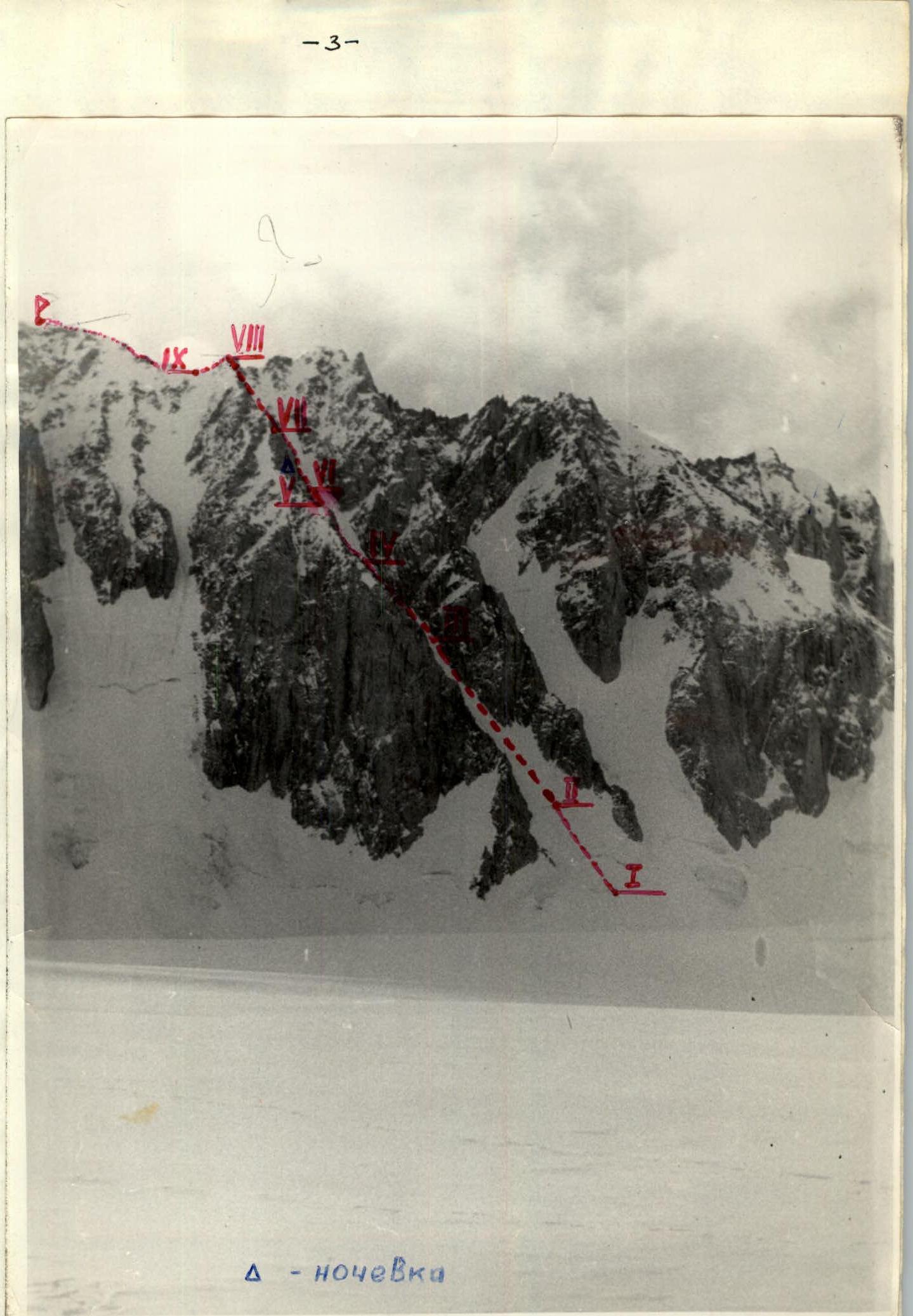
Ascent Route to the Northern Peak of Kovshovykh via the Left Edge of the Western Wall

and Abdukagorka River.
To continue:
- Leave the trail and reach Medvezhiy Glacier where the stream meets the glacier body
- Traverse the glacier ~100 m along the stream
- Cross the stream and rejoin the old trail
- Ascend to the road (2 hours)
Follow the road to the tongue of Abdukagor Glacier. From here, continue on the same trail along the left (orographic) bank of Abdukagor Glacier for 4-5 hours uphill to a small lake on the left moraine of the glacier.
Camp here; it takes 12-14 hours from the base camp. From the lake, Abdukagor II Pass and Zlatoust Peak are visible, which obstructs the view of Kovshovykh Peak.
The next day:
- Cross Abdukagor Glacier
- Reach abandoned geologists' camps on the left moraine of the glacier
- From the camps, rejoin the glacier
- Staying near the left edge (the glacier is heavily broken here), pass by the walls of Zlatoust Peak to reach Abdukagor II Pass, where snow lies all summer
The pass elevation is 5000 m. It takes 6-8 hours from the campsite. From the pass, the Kovshovykh Peak massif is visible. The approach to the chosen route from the pass campsite takes about 1 hour. To protect tents from strong winds on the pass, snow walls need to be built.
Route Description
Two routes to the peaks of the Kovshovykh Peak massif have been established, both rated 5A category difficulty (via the center of the western wall edge and via the NW buttress to the 2nd highest peak). We chose the Northern peak via the left edge of the Western wall as the object of the first ascent.
The route length is ~1000 m with an average steepness of ~45°.
- The lower part of the route features a 300 m long ice slope with a steepness of about 40°.
- The middle part consists of rock formations resembling "ram's foreheads" with ice sections in between, making it challenging for anchoring.
- The exit from the ice to the ridge is via an internal rock corner, 60 m long, with a steepness of 60°.
Before reaching the ridge, a campsite is set up, marked by a cairn.
On the second day:
- Ascend to the summit ridge of Kovshovykh Peak via easy rock formations with piton protection.
- Continue along the rocky ridge with snow sections to reach the summit.
Descend from the summit along the ridge towards Fedchenko Glacier. During the descent, stay on the left-hand side. The descent includes an overnight camp, with limited camping options.
On the third day at 12:00, the group descended to the camp on Abdukagor Pass.
SUMMARY:
- The entire ascent takes 6-7 days, including:
- 2 days for the route,
- 2-3 days to reach Abdukagor Pass,
- 2 days to return to camp.
- Total travel time is 68 hours, with 22-26 hours spent on the route.
- 43 rock pitons and 38 ice screws were used.
Equipment List for a 4-person team:
- 15 carabiners,
- 20-15 rock pitons,
- 8 ice screws,
- 1 tent,
- 2 hammers,
- 320 m main rope,
- 20 m rappel rope.
Future climbers are advised to bring channel pitons.
The ascent participants believe the route difficulty is 5A category. The route is demanding, requiring good rock and ice climbing skills, and is comparable in complexity to such well-known routes as:
- Shchurovsky's route on the NW wall of Koshtan-Tau (Tikhonov Peak),
- Korzhenevskaya Peak — 5B category difficulty.
Table of Main Route Characteristics
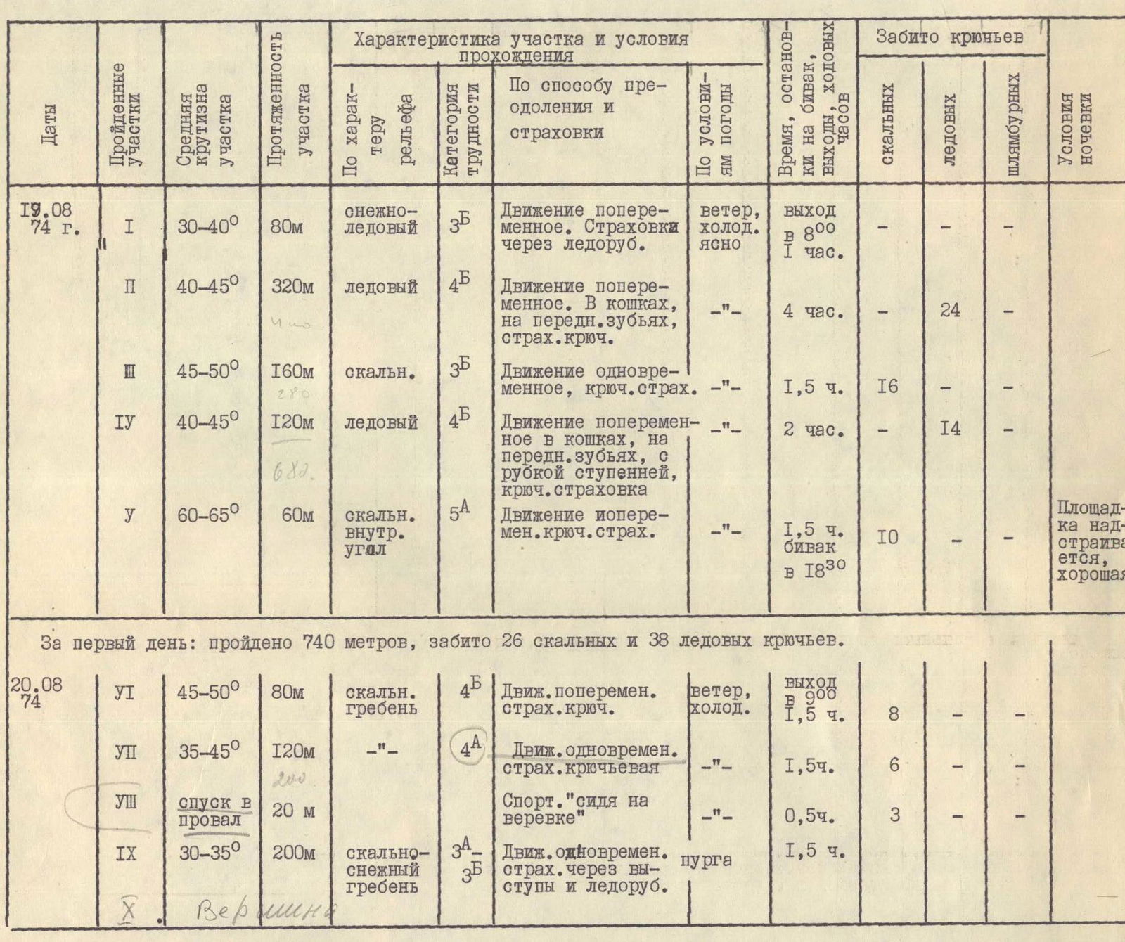
| Dates | Sections traversed | Average steepness of section | Length of section | Relief characteristics | Category of difficulty | Method of ascent and protection | Weather conditions | Time, stops at bivouac, travel hours | Pitons used (rock) | Pitons used (ice) | Pitons used (bolted) | Bivouac conditions |
|---|---|---|---|---|---|---|---|---|---|---|---|---|
| 19.08.74 | R1 | 30–40° | 80 m | snow-ice | 3Б | Variable movement. Protection via ice axe. | wind, cold, clear | Departure at 8:00, 1 hour | – | – | – | |
| R2 | 40–45° | 320 m | ice | 4Б | Variable movement. Crampons, front points, piton protection. | – | 4 hours | – | 24 | – | ||
| R3 | 45–50° | 160 m | rock | 3Б | Simultaneous movement, piton protection. | – | 1.5 hours | 16 | – | – | ||
| R4 | 40–45° | 120 m | ice | 4Б | Variable movement in crampons, front points, step cutting, piton protection. | – | 2 hours | – | 14 | – | ||
| R5 | 60–65° | 60 m | internal rock corner | 5А | Variable movement, piton protection. | – | 1.5 hours, bivouac at 18:30 | 10 | – | – | Site is enlarged, good | |
| 20.08.74 | R6 | 45–50° | 80 m | rocky ridge | 4Б | Variable movement, piton protection. | wind, cold | Departure at 9:00, 1.5 hours | 8 | – | – | |
| R7 | 35–45° | 120 m | – | 4А | Simultaneous movement, piton protection. | – | 1.5 hours | 6 | – | – | ||
| R8 | descent into a gap | 20 m | – | – | Rappelling. | – | 0.5 hours | 3 | – | – | ||
| R9 | 30–35° | 200 m | rocky-snowy ridge | 3А–3Б | Simultaneous movement, protection via rock outcrops and ice axe. | snowstorm | 1.5 hours | – | – | – | ||
| R10 (Summit) |
On the first day: 740 m traversed, 26 rock pitons and 38 ice screws used.
On the second day: 400 m traversed, 17 rock pitons used. TOTAL: 1140 m traversed, 43 rock pitons and 38 ice screws used.