ASCENT PERFORMED IN THE USSR CHAMPIONSHIP IN ALPINISM ON AUGUST 15, 1977
Ascent Class — High-altitude
Ascent Area — Central Pamir
Ascent Route — Peak Izvestiy via the southeast wall
Ascent Characteristics
- Altitude difference — 2050 m
- Route length — 2680 m
- Average steepness — 72° (wall)
- Length of complex sections — 1300 m (altitude difference — 1150 m; average steepness — 85°)
Pitons driven:
- Rock — 227 (including 28 for ITО)
- Ice — 5
Climbing hours — 69.5
Number of nights:
- On the wall — 6
- During processing — 1
Total climbing days:
- On the wall — 6
- During processing — 1
- On descent — 2
Team composition:
- Chunovkin G.A. — MS, captain
- Zayonchkovsky A.Ya. — MS, deputy captain
- Borzov Yu.V. — MS
- Lazarev V.P. — MS
- Shalygin Yu.V. — MS
- Kletsko K.B. — CMS
- Kolmykov S.G. — MS
- Lurye V.R. — MS
- Ilyin A.V. — 1st sports category
Team coach — Honored Coach of the RSFSR Chunovkin G.A.
Ascent dates:
- August 7 — processing
- August 7–13 — ascent up the wall
- August 13–15 — descent
Team's final position —
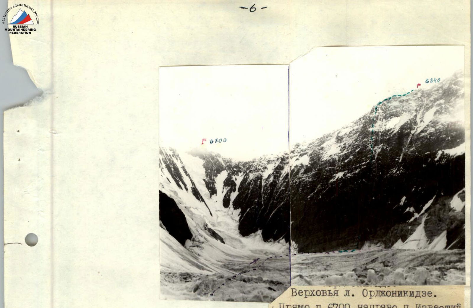
Upper reaches of the Ordzhonikidze Glacier. Directly Peak 6700, to the right Peak Izvestiy.
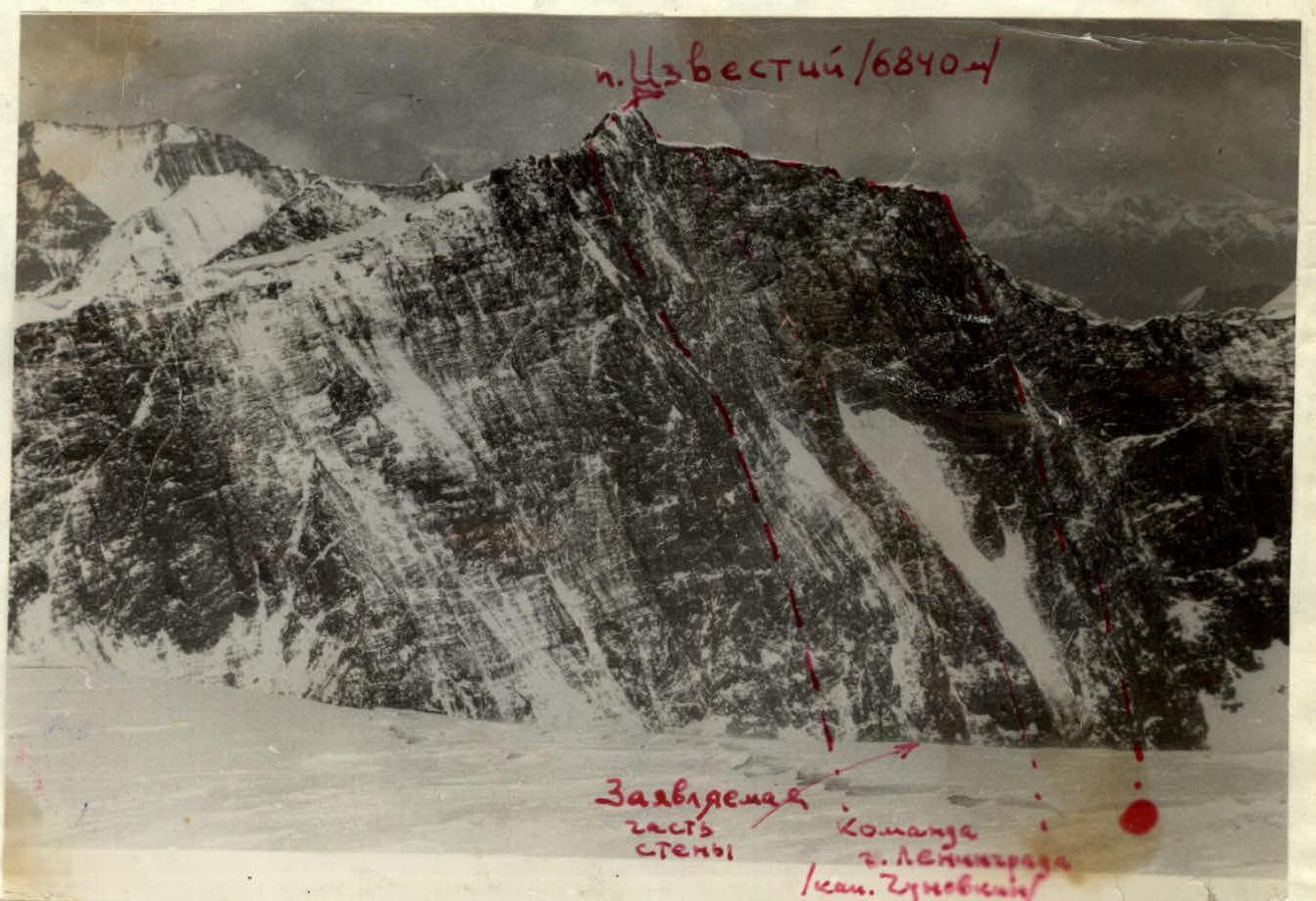 Peak Izvestiy from Peak 6700 (photo from 1972)
This photo was attached to the application and was the only photographic document available to the team before departure.
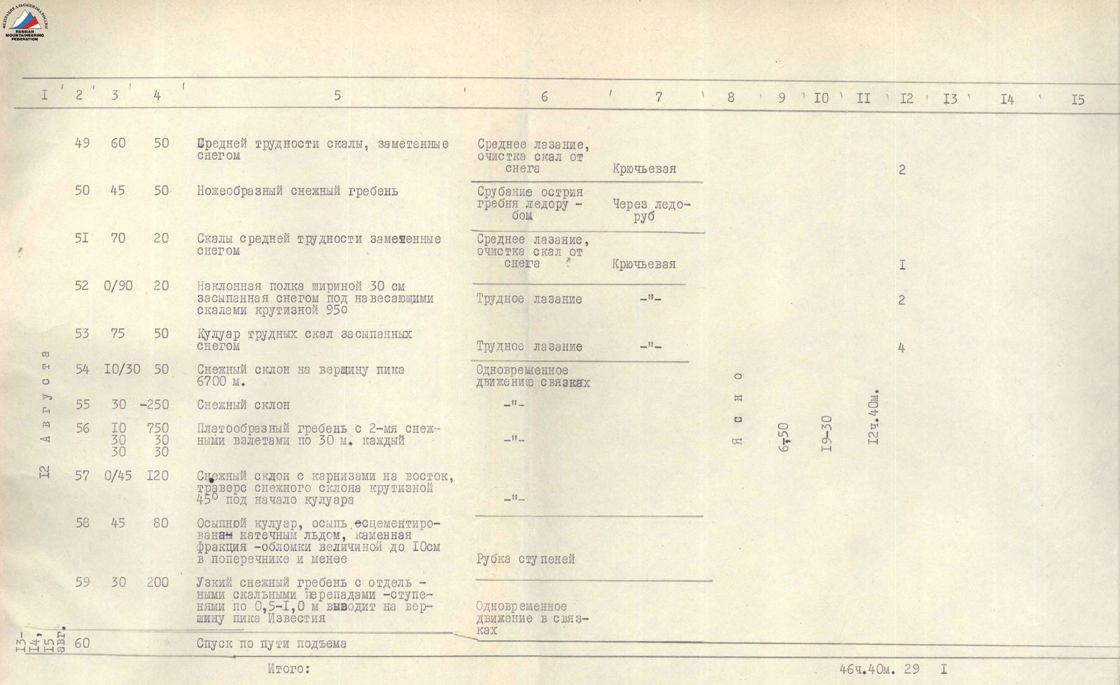
Table of main characteristics of the ascent route to Peak Izvestiy
The fraction in column 3 shows: the numerator indicates the slope of the path, the denominator indicates the steepness of the slope; in column 5: the numerator indicates the steepness of the ridge slope on the left in the direction of travel, the denominator indicates the steepness of the ridge slope on the right in the direction of travel.

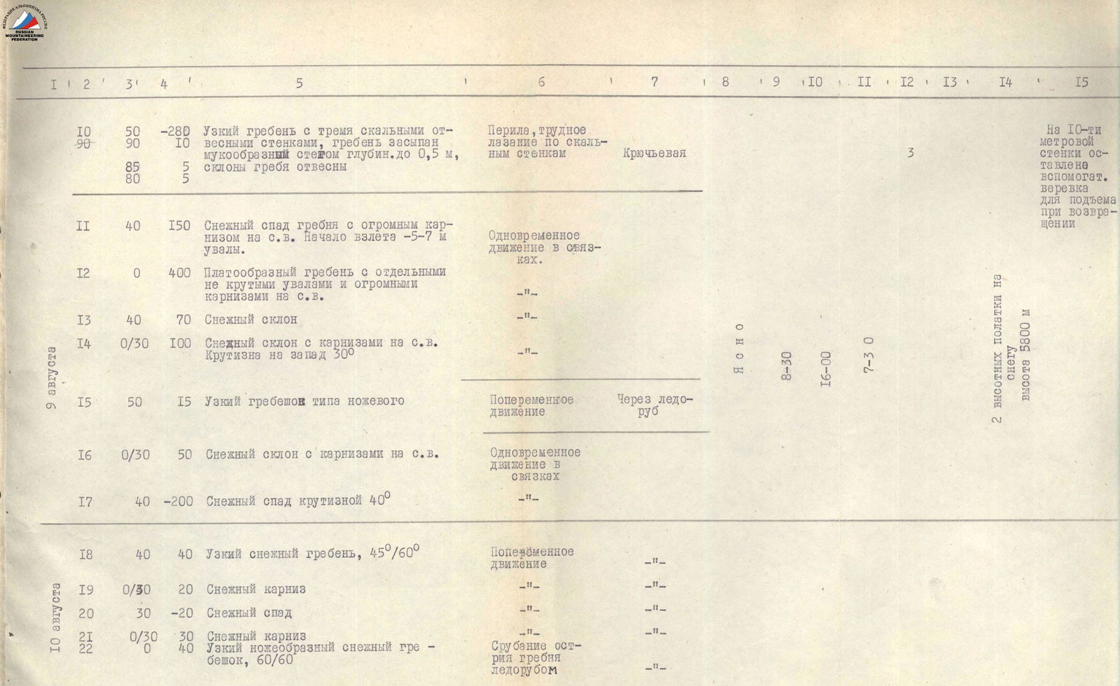
| № | Sections traversed | Average steepness of the section in degrees | Section length by height | Characteristics of sections and conditions of their passage (By terrain character) | By technical difficulty | By belay method | By weather conditions | Time of departure | Time of stopping at bivouac | Climbing hours | Pitons driven: Rock | Pitons driven: Ice | Night accommodation conditions and height | Notes |
|---|---|---|---|---|---|---|---|---|---|---|---|---|---|---|
| 0 | 45°/90° | 200 m | Large and medium talus, destroyed rocks | Simultaneous movement in rope teams | Sometimes belay through outcrops | 2 high-altitude tents on snow, height 6000 m | ||||||||
| 1 | 23°/30° | 150 m | Rock shelf 0.5 m wide, shale-like rocks | |||||||||||
| 2 | 30°/40° | 200 m | Ridge-like snow ascent, snow ascents alternating with narrow ridges | |||||||||||
| 3 | 45° | 500 m | Snow slope | |||||||||||
| 4 | 0°/40° | 120 m | Traverse of snow slope with 40° steepness | Alternate movement | Through ice axe | |||||||||
| 5 | 10°/–80° | 80 m | Snow ridge 0.3 m wide | Cutting the ridge edge with an ice axe | ||||||||||
| 6 | 60°/–80° | 80 m | Stepped rock ridge with narrow and thin cornices on both sides | Through outcrops, piton belay |
| № | Sections traversed | Average steepness of the section in degrees | Section length by height | Characteristics of sections and conditions of their passage (By terrain character) | By technical difficulty | By belay method | By weather conditions | Time of departure | Time of stopping at bivouac | Climbing hours | Pitons driven: Rock | Pitons driven: Ice | Night accommodation conditions and height | Notes |
|---|---|---|---|---|---|---|---|---|---|---|---|---|---|---|
| 7 | 50°/90° | 280 m | Narrow ridge with three rock sheer walls, ridge covered with mud-like snow up to 0.5 m deep, ridge slopes are sheer | Ropes, difficult climbing on rock walls | Piton belay | 3 | ||||||||
| 8 | 40° | 150 m | Snow descent of the ridge with a huge cornice to the northeast. Beginning of ascent 5–7 m hills. | Simultaneous movement in rope teams | Clear | 8:00 | 16:00 | 7 h 30 min | 2 high-altitude tents on snow, height 5800 m | A spare rope left on a 10-meter wall for ascent during descent | ||||
| 9 | 0° | 400 m | Plateau-like ridge with individual gentle hills and huge cornices to the northeast. | |||||||||||
| 10 | 40° | 70 m | Snow slope | |||||||||||
| 11 | 0°/30° | 100 m | Snow slope with cornices to the northeast. Steepness to the west 30° | |||||||||||
| 12 | 50° | 15 m | Narrow ridge like a knife edge | Alternate movement | Through ice axe | |||||||||
| 13 | 0°/30° | 50 m | Snow slope with cornices to the northeast. | Simultaneous movement in rope teams | ||||||||||
| 14 | 40° | 200 m | Snow descent with 40° steepness | |||||||||||
| 15 | 40° | 40 m | Narrow snow ridge, 45°/60° | Alternate movement | "- | |||||||||
| 16 | 0°/30° | 20 m | Snow cornice | "- | ||||||||||
| 17 | 30° | 20 m | Snow descent | "- | ||||||||||
| 18 | 0°/30° | 30 m | Snow cornice | "- | ||||||||||
| 19 | 0° | 40 m | Narrow knife-like snow ridge, 60°/60° | Cutting the ridge edge with an ice axe |

| № | Sections traversed | Average steepness of the section in degrees | Section length by height | Characteristics of sections and conditions of their passage (By terrain character) | By technical difficulty | By belay method | By weather conditions | Time of departure | Time of stopping at bivouac | Climbing hours | Pitons driven: Rock | Pitons driven: Ice | Night accommodation conditions and height | Notes |
|---|---|---|---|---|---|---|---|---|---|---|---|---|---|---|
| 20 | 50° | 160 m | Knife-like snow ridge | Cutting the ridge edge with an ice axe | Through ice axe | |||||||||
| 21 | 45°/70° | 180 m | Knife-like snow ridge with two walls: 1. rock — 10 m, 2. ice — 5 m | Cutting the ridge edge, ice axe steps, medium climbing | Through ice axe, piton belay | |||||||||
| 22 | 35°/60° | 150 m | Knife-like snow ridge with three snow "gendarmes" 5, 10, and 8 m high | Cutting the ridge edge, alternate movement in rope teams | Through ice axe | Strong wind until 11 am, light cloud cover | 10:00 | 19:00 | 9 h | 2 high-altitude tents on snow, height 6350 m | ||||
| 23 | 60° | 60 m | Bypassing a rock ascent via a snow slope, ascent is sheer | Movement in three steps | ||||||||||
| 24 | 40° | 150 m | Wide snow ridge | Simultaneous movement in rope teams | ||||||||||
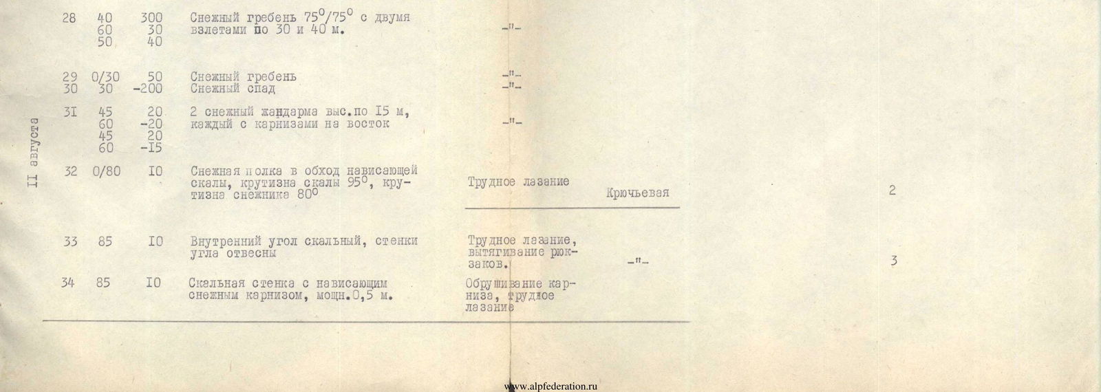
| 25 | 40°/60° | 300 m | Snow ridge 75°/75° with two ascents of 30 and 40 m | "- | ||||||||||
| 26 | 0°/30° | 50 m | Snow ridge | "- | ||||||||||
| 27 | 45°/60° | 20 m | 2 snow "gendarmes" 15 m high each with cornices to the east | "- | ||||||||||
| 28 | 0°/80° | 10 m | Snow shelf bypassing an overhanging rock, rock steepness 95°, snow slope steepness 80° | Difficult climbing | Piton belay | 2 | ||||||||
| 29 | 85° | 10 m | Internal rock corner, corner walls are sheer | Difficult climbing, pulling up backpacks | "- | 3 | ||||||||
| 30 | 85° | 10 m | Rock wall with an overhanging snow cornice 0.5 m thick | Removing the cornice, difficult climbing | "- |
 |  |
|---|---|
 |  |
| № | Sections traversed | Average steepness of the section in degrees | Section length by height | Characteristics of sections and conditions of their passage (By terrain character) | By technical difficulty | By belay method | By weather conditions | Time of departure | Time of stopping at bivouac | Climbing hours | Pitons driven: Rock | Pitons driven: Ice | Night accommodation conditions and height | Notes |
|---|---|---|---|---|---|---|---|---|---|---|---|---|---|---|
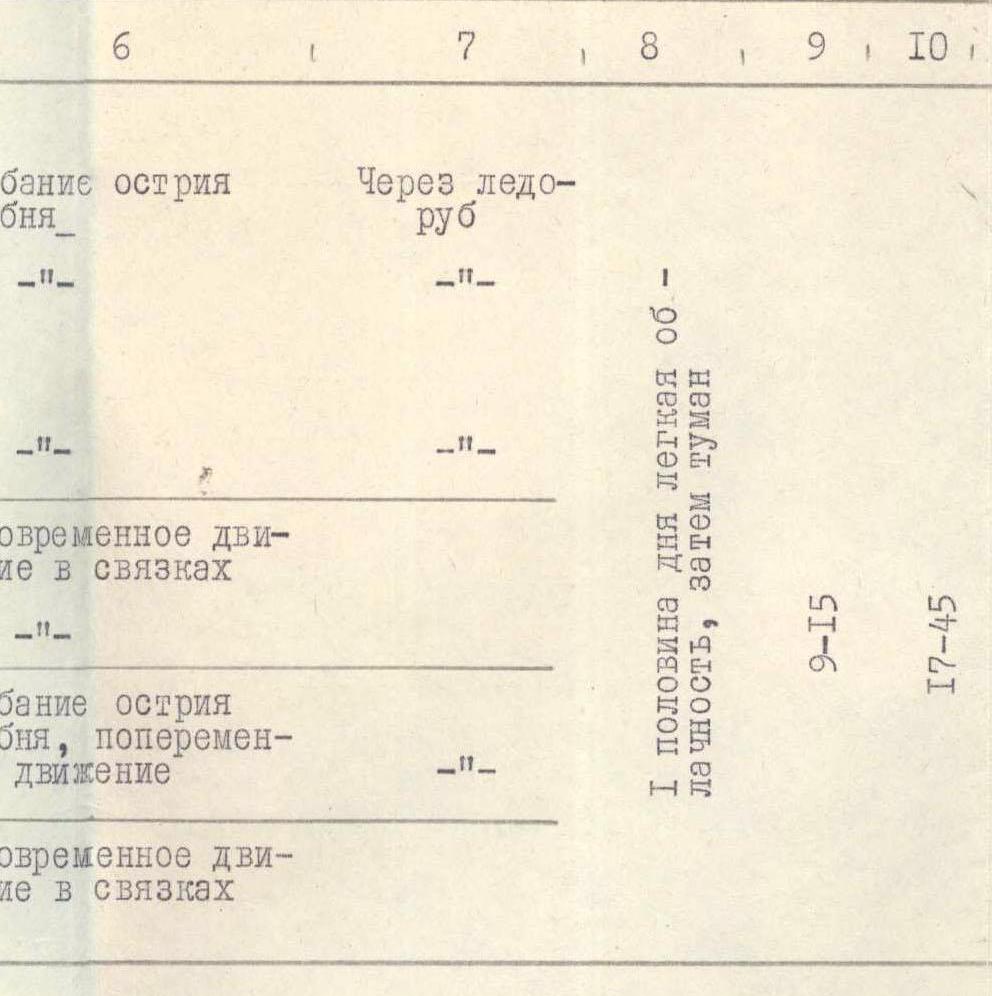
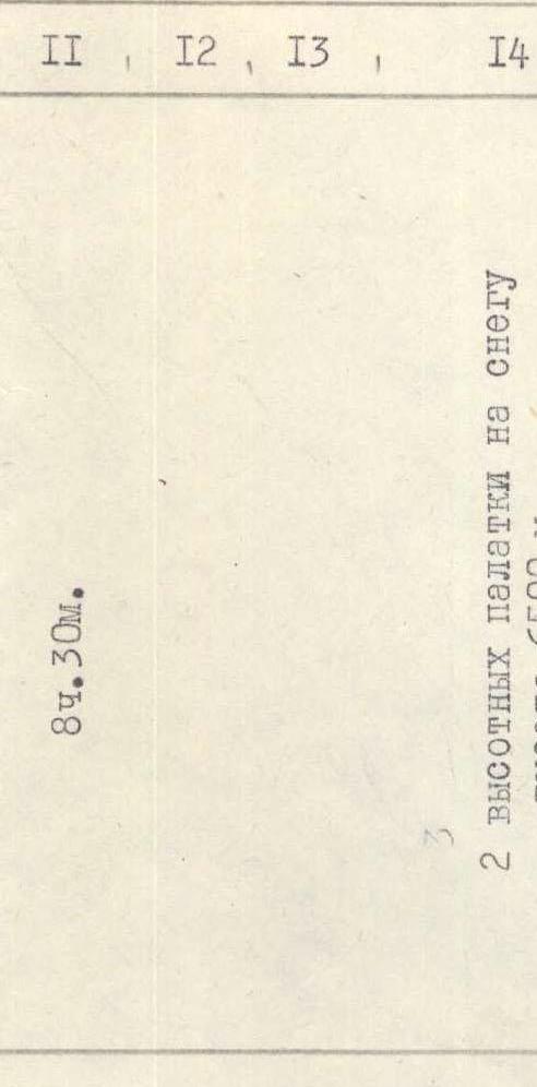
| 31 | 60°/–10° | 25 m | Narrow snow ridge with thin cornices to the east, 80°/80° | Cutting the ridge edge | Through ice axe | 2 high-altitude tents on snow, height 6500 m | ||||||||
| 32 | 10° | 40 m | Knife-like snow ridge 75°/75° | "- | ||||||||||
| 33 | 0° | 200 m | Zigzag ridge with individual descents and ascents of 5–7 m. Steepness of descents and ascents 45–50°. Steepness of slopes 75°/75° | "- | ||||||||||
| 34 | 45° | –40 m | Snow descent | Simultaneous movement in rope teams | First half of the day — light cloud cover, then fog | 8:15 | 9:15 | 8 h 30 min | ||||||
| 35 | 10° | 80 m | 3 plateau-like ascents like hills | |||||||||||
| 36 | 40° | 60 m | Knife-like ridge | Cutting the ridge edge, alternate movement | ||||||||||
| 37 | 30° | 20 m | 2 snow ascents. | Simultaneous movement in rope teams | ||||||||||
| 38 | 45° | 30 m | Snow slope | Simultaneous movement in rope teams | ||||||||||
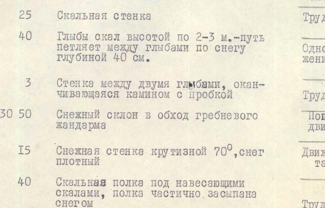
| 39 | 80° | 25 m | Rock wall | Difficult climbing | Piton belay | 4 | ||||||||
| 40 | 0° | 40 m | Boulders 2–3 m high — path winds between boulders on snow 40 cm deep. | Simultaneous movement in rope teams | ||||||||||
| 41 | 90° | 3 m | Wall between two boulders ending in a chimney with a plug | Difficult climbing | Boosting | |||||||||
| 42 | 15°/30° | 50 m | Snow slope bypassing a ridge "gendarme" | Alternate movement | Through ice axe | |||||||||
| 43 | 70° | 15 m | Snow wall with 70° steepness, snow is dense | Movement in three steps | ||||||||||
| 44 | 0° | 40 m | Rock shelf under overhanging rocks, partially covered with snow | Difficult climbing | Piton belay | 6 |
| № | Sections traversed | Average steepness of the section in degrees | Section length by height | Characteristics of sections and conditions of their passage (By terrain character) | By technical difficulty | By belay method | By weather conditions | Time of departure | Time of stopping at bivouac | Climbing hours | Pitons driven: Rock | Pitons driven: Ice | Night accommodation conditions and height | Notes |
|---|---|---|---|---|---|---|---|---|---|---|---|---|---|---|
| 45 | 60° | 50 m | Foothill snow ridge, snow-covered | Medium climbing, clearing snow from rocks | Piton belay | 2 | ||||||||
| 46 | 45° | 50 m | Knife-like snow ridge | Cutting the ridge edge with an ice axe | Through ice axe | |||||||||
| 47 | 70° | 20 m | Rocks of medium difficulty, covered with snow | Medium climbing, clearing snow from rocks | Piton belay | 1 | ||||||||
| 48 | 0°/90° | 20 m | Inclined shelf 30 cm wide, covered with snow under overhanging rocks with 95° steepness | Difficult climbing | "- | 2 | ||||||||
| 49 | 75° | 50 m | Couloir of difficult rocks, covered with snow | Difficult climbing | "- | 4 | ||||||||
| 50 | 10°/30° | 50 m | Snow slope to the summit of Peak 6700 m | Simultaneous movement in rope teams | Clear | 6:50 | 19:30 | 12 h 40 min | 29 | 1 | ||||
| 51 | 30° | –250 m | Snow slope | "- | ||||||||||
| 52 | 10° | 750 m | Plateau-like ridge with two snow ascents of 30 m each | "- | 2 | |||||||||
| 53 | 0°/45° | 120 m | Snow slope with cornices to the east, traverse of snow slope with 45° steepness under the beginning of the couloir | "- | ||||||||||
| 54 | 45° | 80 m | Talus couloir, talus cemented with rime ice, stone fraction — fragments up to 10 cm in diameter and less | Step cutting | 1 | |||||||||
| 55 | 30° | 200 m | Narrow snow ridge with individual rock steps — 0.5–1.0 m high leads to the summit of Peak Izvestiy | Simultaneous movement in rope teams | ||||||||||
| 56 | Descent via the ascent route | |||||||||||||
| Total: | 46 h 40 min | 29 | 1 | Notes: Throughout the entire route, the snow depth was not less than 30 cm, sometimes reaching 50 cm or more on leeward sections. |
Brief geographical and sports characteristics of the ascent area
Peak Izvestiy is located in the Academy of Sciences ridge in the upper reaches of the S. Ordzhonikidze Glacier. The relative inaccessibility of the upper reaches of this glacier has affected its popularity among mountaineering expeditions. It should be noted that opposite the southeast wall of Peak Izvestiy are the northern slopes of Peak Communism. Here, ascents were made along two routes by teams from:
- Tashkent (captain Voronin A.)
- Leningrad (captain Borisenok O.)
The start of the route to Peak Izvestiy is located almost opposite the "Voronin rib" (4800 m). The southern slopes of the gorge remained untouched until this mountaineering season.
To ensure a successful ascent, the team had to solve several tasks:
- Find an acceptable path along the Ordzhonikidze Glacier from known bivouacs (4500 m) under the beginning of the route to Peak Communism to the base of the wall of Peak Izvestiy;
- Choose a convenient and safe location for the assault camp at the start of the route;
- Study the character of the wall to assess its rockfall danger, detailed route selection, and mark bivouac locations;
- Process the start of the route;
- Determine the descent path;
- Evaluate radio communication locations for subsequent communication with the base camp.
To address these tasks, a plan was developed for the preparatory period. The plan included the following key points:
- To address acclimatization, review the descent path from Peak Izvestiy along the ridge through Peaks Pioneer Pravda (6600 m) and S. Ordzhonikidze (6300 m); for this purpose, training ascents were made to both peaks, and cargo drops were conducted. From the summit of Pioneer Pravda, the descent path from Peak Izvestiy was reviewed.
- Conduct cargo delivery to the Ordzhonikidze Glacier, mark the passage routes along it (four trips were made to the glacier via different routes, and the best path was chosen).
- Conduct prolonged observation of the wall to determine its daily regime and assess illumination (observation was carried out from a height of 4700 m from a safe location on the Ordzhonikidze Glacier for 5 days).
The southeast wall has been the subject of preliminary applications from various teams over the past few years. Our team also submitted an application for the third time. During the sports seasons of 1973 and 1975, we managed only to review the wall and familiarize ourselves with the area. Difficulties in transporting cargo and a lack of time due to not finding good passage routes along the Ordzhonikidze Glacier prevented the organization of the ascent.
Independent ascents:
- In 1964, a group from Tashkent led by V. Zilchibekov ascended Peak Izvestiy; our team retrieved their note a few days (August 5) before reaching the summit.
- A group of coaches from the PAMI "Pamir-77" led by Comrade Cherny climbed to the ridge crest from the Walter Glacier a few days before our ascent but did not reach the summit due to poor visibility (about 200 m remained).
It should be noted that the bend of the ridge near Peak Izvestiy does not allow for a profile photo of the route. The most suitable photos for this purpose were taken by the team in 1972 from Peak 6700 during their descent from Peak Communism.
Preparation for the ascent
During the pre-season preparation, team members trained in LOS "Trud" (coach Chunovkin), "Burevestnik" (coach Zhitenev), and "Spartak" collectives. In June, joint training sessions were held at the rocks of the Karelian Isthmus. Some participants made ascents in the "Artuch" and "Varzob" alpine camps before the expedition.
Upon arrival at the bivouac glacier on July 20, the entire expedition team participated in acclimatization and reconnaissance trips on the Bivouac and Ordzhonikidze glaciers. Team members made ascents to Peaks Ordzhonikidze and Pioneer Pravda, making cargo drops along the planned descent route. Acclimatization and reconnaissance trips were completed by July 30, resulting in all team members achieving the necessary athletic form.
It was established that VHF radio communication (using the "Vitalka" radio station) from the ascent area to the base camp was possible only from the slopes of:
- Peak Communism (above 5600 m)
- Peak Ordzhonikidze (eastern ridge above 5000 m)
On August 1, a group consisting of Zayonchkovsky, Borzov, Kalmykov, Ilyin, and Shalygin processed the start of the route to Peak Izvestiy.
To begin the ascent, the team departed from the base camp on August 5. Simultaneously, an auxiliary group consisting of Maragin, Stankevich, Yankin, Karpov, Eltushev, Zadvoriev, and Lukyanov departed to ascend Peak Communism via the eastern rib. Their tasks included:
- Relaying radio transmissions between the team and the base camp
- Observing the wall of Peak Izvestiy
- Photographing the route
- Correcting the team's direction if necessary
It was decided not to locate the observation point directly under the route on the Ordzhonikidze Glacier due to the lack of radio communication from there with the base camp and the risk of avalanches: during the team's ascent, large avalanches were observed from the slopes of Peak Communism, blocking the glacier from edge to edge. The primary sources of these avalanches were the icefalls from the Voronin route and from under Peak 6700.
Ascent Chronicle
August 1, 1977
At 8:00, the trio Borzov—Zaychkovsky—Shalygin departed from the assault camp on the Ordzhonikidze Glacier to process the start of the route. After 1.5 hours, they reached the plateau under the wall where equipment had been left the previous day. For an hour, they observed the wall and decided to start the route via a slightly protruding "iron" composed of light-colored rocks. At 11:00, the team began ascending the snow-ice cone to the base of the "iron" (section R0–R1), crossing the bergschrund via a bridge. Under the base of the "iron," Yu. Borzov replaced his crampons with galoshes and began climbing the rock wall.
The initial steps were very challenging due to steep rocks with weak micro-relief (section R1–R2). After 20 m, they made a traverse to the right under an overhang towards a large internal corner (section R2–R3). They climbed the left wall of the corner until reaching hanging rust-colored rocks (section R3–R4), then traversed left under the base of a vaguely defined vertical internal corner with significantly destroyed relief.
The ascent continued up the corner, exiting onto more gentle rocks and then right-up (section R6–R7) under an overhanging wall. The wall was traversed via a crack intersecting it from left to right-up. Climbing was very difficult, complicated by two protruding plugs in the crack (section R7–R8). Artificial points of support (ITO) were used twice with the help of clamps. The crack ended at the upper boundary of the light-colored rock belt.
Further movement was directly upward (section R9–R10), exiting onto a shelf
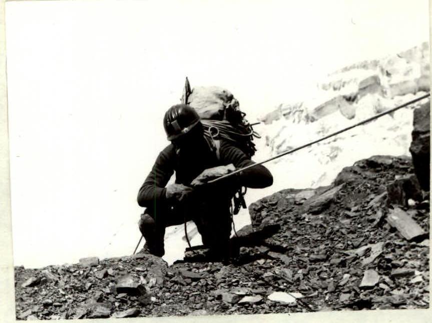
First bivouac, radio communication with the auxiliary group was established on severely destroyed rocks with a slab-like structure. Many "live stones," rocks were unstable (section R8–R9), requiring great caution and using the tactic "one climbs — all stand still." The team overcame this section and exited onto a slope covered with talus (section R9–R10). This was the "roof" of the "iron." Stones thrown from here fell into the couloirs on either side of the "iron."
From the "roof," they exited onto a wall with a characteristic vertical crack at the top (section R10–R11). A tower above the wall was bypassed on the left, exiting into the base of a short rock couloir (section R11–R12). Movement was right-up under a rock "forehead." Here, the end of the last (sixth) rope was secured. Time: 15:30.
The maximum plan was achieved. The team began descending and by 18:00, meeting the observing duo Ilyin—Kalmykov, returned to the assault camp. Tomorrow, everyone was to descend to the base camp for rest before the ascent.
August 7, 1977
The ascent began at 6:00. At 7:30, the duo Borzov—Zaychkovsky left the assault camp. They were followed by the rest of the team. The pace was slowed due to each rucksack carrying 9–10 kg of shared gear. At 9:00, the leading duo began moving along the processed part of the route. After four hours of strenuous climbing on ropes with backpacks, the duo reached the upper point of the ropes and began further processing of the route. They had 2 ropes at their disposal, which were secured on the first half of section R12–R14 within an hour. Additional ropes were brought up, and by 15:30, section R13–R14 was processed.
The terrain consisted of:
- Rocks like "foreheads" with medium steepness ∼70°
- Individual vertical sections of 2–6 m
By 17:30, the closing duo Ilyin—Kalmykov reached the designated location for the night's bivouac. Construction work began. Within an hour and a half, two platforms were ready on the "roof" of the "iron," allowing for relatively comfortable accommodation. Challenges arose in obtaining water, requiring a 20-meter traverse to the right with belay to a couloir. In the tents, under the sound of primus stoves, lively discussions took place about the day's progress and experiences.
August 8, 1977
The ascent began at 7:00. At 8:00, the duo Borzov—Zaychkovsky, loaded with ropes and equipment, moved upward.
The terrain character over the next 80 m above the processed section remained similar (section R14–R15). Further:
- 50 m of steeper but unstable and destroyed rocks (section R15–R16),
- A traverse left into the throat of a rock couloir (section R16–R17) led under the base of a bastion.
The newly arrived Shalygin passed on the freed ropes. Timely! The ascent continued up the right wall of the bastion (section R17–R18). The vertical rocks had a large-block structure, making climbing challenging. An entry was made onto a "tooth" between a large block and the wall. Above the "tooth" was an overhanging section of rocks 5–6 m high without cracks at the bottom. Borzov, standing on Zaychkovsky's shoulders, managed to reach and drive a piton (section R18–R19). Two more pitons and ladders followed, and he reached the top of the bastion, where a blocked platform was found.
By this time, the rest of the group was within sections R14–R17. Time: 15:30. The processing team descended and, after a brief discussion with the leader, decided that everyone would proceed to the end of the processed section. By 18:00, the last member (V. Lurye) climbed onto the shelf designated for the night's bivouac. Clearing and construction work was in full swing. Again, ice had to be fetched from the right, almost on a rope. They stocked up on ice for the next morning as well. By 19:30, everyone was in their tents. The day's total was 11 ropes traversed.
August 9, 1977
The ascent began at 7:00. At 8:30, the duo Borzov—Zaychkovsky started processing the further route.
After a 40-meter wall (section R19–R20):
- A 10-meter traverse left through an internal corner (section R20–R21)
- Exit into a wide internal corner (section R21–R22) with significantly dissected relief
Movement was complicated by numerous "live" stones. After 40 m, the corner ended in an overhang. From under the overhang, they exited right onto a wall. Challenging climbing followed on steep (85°) brittle rocks with


