Description
First ascent of Peak 5731 from the Bivachny Glacier by participants of the Pamir expedition of the Ukrainian Council of the Spartak Volunteer Sports Society
August 4–7, 1967
Leader — V. Rudenya, coach — I. Polevoy. Participants:
- S. Slenzak
- V. Golub
- I. Batmanova
- V. Yefimov
- D. Kamayev
- A. Karatsuba
- V. Kolesnik
- A. Klokova
- R. Bazilevich
- G. Aprelenko
- G. Shalayev
- V. Cherevko

Map of the ascent to Peak 5731
Brief description of Peak 5731
Peak 5731 is located in the eastern ridge of Peak Russia, which is a continuation of the Academy of Sciences Range, in the Central Pamir region. Its massif closes the basin of the Bivachny Glacier from the south, which is a left tributary of the Fedchenko Glacier.
Organization of the ascent
During the ascent to Peak 5731, carried out by a group of climbers from the Kiev Regional Council of the Spartak Volunteer Sports Society, Science Sports Club, the task was to organize intermediate camps and conduct active acclimatization — all as part of preparation for the ascent to Peak Kommunizma.
The group became familiar with the peak and the area during the work of the Central Council of the Spartak Volunteer Sports Society expedition in 1966. The idea of the first ascent to Peak 5731 arose back then, but a number of circumstances prevented the implementation of this plan.
The group was provided with:
- down suits and shell jackets;
- a "Nedra" type radio station for communication with the camp.
Description of the ascent
Day 1. From the base camp on the left (orographically) lateral moraine of the Fedchenko Glacier, 10 km from the end of the tongue, up the moraine to the confluence of the Bivachny and Fedchenko glaciers. From here, crossing the Bivachny Glacier, up the right (orographically) lateral moraine of the Bivachny Glacier to a lake at an elevation of 3900 m. Overnight stay.
Day 2. From the "3900" camp (a large cache had been made there earlier) across the rocky Bivachny Glacier to the confluence of its left tributary. From here, initially under the continuation of the ridge of Peak Russia, called the "Shirma" (a rockfall-prone area), then directly across the glacier (moving in teams, simultaneously) and, overcoming a small icefall, exit to the intermediate "4700" camp under the slopes of Peak Radioklub. 9 hours from the "3900" camp.
Day 3. From the "4700" camp, in teams, all participants in crampons, ascent up the left side of the heavily crevassed 400-meter icefall. In the lower part, crevasses are navigated with alternating belays; in the upper part, to overcome a crevasse, it was necessary to hang a rope — 4 ice screws. From here, with some gain in height, exit to a snow-firn plateau to the second stage of the icefall. Height 5100 m.
Day 4. From the overnight stay, left and up towards the slopes of Peak Russia (closed crevasses, careful belay through an ice axe). Further traverse of the southwest slope of Peak 5731 to the bergschrund. Overcoming the bergschrund (ice wall — 80°, 2 m):
- is overcome with lower belay through an ice axe and step cutting (2 ice screws);
- further — 2 ropes on the ice slope (steepness about 35°) and exit to rocks (4 ice screws);
- from rocks across snow to the pre-summit bergschrund (60 m);
- crossing the bergschrund — 2 ice screws;
- ascent up the ice slope 35–45° to a pile of rocks under the summit (80 m);
- step cutting, 4 ice screws;
- from rocks — one rope to the summit.
The entire ascent took 7 hours. Descent along the ascent route — 4.5 hours.
Days 5, 6. Return to the base camp.
Group's conclusion about the route
In terms of relief character, technical difficulty, and high-altitude conditions, this route corresponds to a category 4B route.
Recommendations for the route
-
Group of 4–6 people.
-
Equipment for 4 people:
- main rope 2 × 40 m
- expendable rope 6 m
- ice screws 4–6
- hammers 2
- carabiners 4–5
- crampons 4 pairs
- Exit on the route — early in the morning.

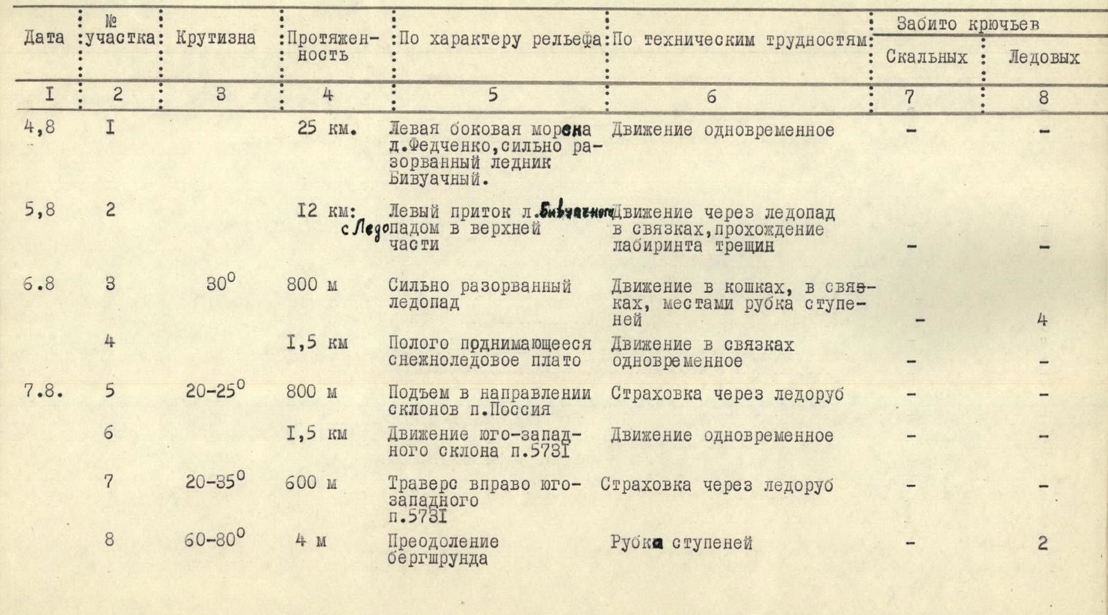
| Date | Section | Steepness | Length | By relief character / By technical difficulties | Rock | Ice |
|---|---|---|---|---|---|---|
| 4,8 | 1 | 25 км | Left lateral moraine of Fedchenko Gl., heavily crevassed Bivachny Gl. Simultaneous movement | - | - | |
| 5,8 | 2 | 12 км | Left tributary of Bivachny Gl. Movement through icefall in teams, navigating a labyrinth of crevasses | - | - | |
| 6,8 | 3 | 30° | 800 м | Heavily crevassed icefall. Movement in crampons, in teams, местами рубка ступеней | - | 4 |
| 4 | 1,5 км | Gently rising snow-ice plateau. Simultaneous movement in teams | - | - | ||
| 7,8 | 5 | 20–25° | 800 м | Ascent towards slopes of Peak Russia. Belay through ice axe | - | - |
| 6 | 1,5 км | Movement on southwest slope of Peak 5731. Simultaneous movement | - | - | ||
| 7 | 20–35° | 600 м | Traverse right on southwest slope of Peak 5731. Belay through ice axe | - | - | |
| 8 | 60–80° | 4 м | Overcoming bergschrund. Step cutting | - | 2 | |
| 7,8 | 9 | 35° | 80–90 м | Ice slope, exit to rocks. Movement with alternating belay | - | 4 |
| 10 | 20–25° | 60 м | Snow slope. Simultaneous movement | - | - | |
| 11 | 35–40° | 30 м | Snow ascent. Exit to pre-summit bergschrund. Belay through ice axe | - | - | |
| 12 | 60–80° | 3 м | Overcoming bergschrund. Step cutting | - | 2 | |
| 13 | 35–40° | 80 м | Ice slope. Exit to pile of rocks under summit. Step cutting | - | 4 | |
| 14 | 20–25° | 40 м | Snow ridge. Exit to summit. Simultaneous movement | - | - | |
| 8–9 August | Return to base camp along ascent route |


